Ang Mo Kio is a planning area and residential town situated in the North-East region of Singapore. Located approximately 11 km (6.8 mi) north of the Downtown Core district, Ang Mo Kio is the 3rd most populated planning area in the North-East region and ranks 8th in terms of population in the country overall. The planning area is located at the south-western corner of the North-East region, bordered by the planning areas of Yishun to the north, Sengkang to the north-east, Serangoon to the east, Bishan to the south and the Central Water Catchment to the west.
Clementi is a planning area and residential town located at the easternmost fringe of the West Region of Singapore. The town borders Bukit Batok to the north, Bukit Timah to the northeast, Queenstown to the east and Jurong East to the west.

Pasir Ris, is a planning area and residential town located in the East Region of Singapore. It is bordered by Tampines and Paya Lebar to the south, Sengkang to the southwest and Changi to the east. The planning area also shares riverine boundary with Punggol to the west, separated by the Serangoon River, as well as having a maritime boundary with the North-Eastern Islands planning area, across the Straits of Johor.

Kallang is a planning area and residential zone located in the Central Region of Singapore.

Tampines is the regional centre of the East Region of Singapore. With a population of 274,360 living across its five subzones, it is the second-most populous planning area in Singapore, according to the DOS Population Trends 2023. It is home to approximately 5% of Singapore's population. Tampines is bordered to the west by Bedok and Paya Lebar, to the north by Pasir Ris, to the east by Changi, and to the south by the Straits of Singapore. Situated in the historical region of Tanah Merah, its present-day terrain is particularly flat due to the large-scale sand quarrying in the 1960s.

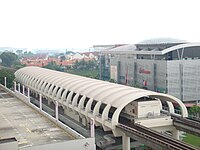
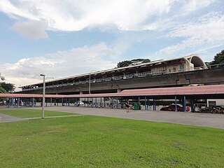
Simei MRT station is an above-ground Mass Rapid Transit (MRT) station on the East–West line in Tampines planning area, Singapore, at the centre of Simei housing estate flanked by Simei Street 1 and Simei Street 3 next to Eastpoint Mall. This station primarily serves Simei, a residential estate part of the larger Tampines New Town.

Bedok is a planning area and residential town located in the geographical region of Tanah Merah along the south-eastern coast of the East Region of Singapore. Bedok is bounded by five other planning areas: Paya Lebar to the north, Hougang to the northwest, Tampines to the northeast and east, Geylang to the west and Marine Parade to the southwest. It also shares a maritime boundary with the Singapore Strait to the south and southeast.
Bukit Merah, also known as Redhill, is a planning area and new town situated in the southernmost part of the Central Region of Singapore. The planning area borders Tanglin to the north, Queenstown to the west and the Downtown Core, Outram and Singapore River planning areas of the Central Area to the east. It also shares a maritime boundary with the Southern Islands planning area to the south. Bukit Merah is linked to Sentosa Island via Sentosa Gateway, Sentosa Broadwalk, Sentosa Express and the Cable Car.

Tampines MRT station is a Mass Rapid Transit (MRT) interchange station on the East West (EWL) and Downtown (DTL) lines in Tampines, Singapore. Located in the heart of the Tampines town centre next to Tampines Avenue 4, Tampines Central 4 and Tampines Central 5, it is in close proximity to the Tampines and Tampines Concourse bus interchanges. The station also serves the surrounding retail developments of Tampines Mall, Tampines One and Century Square.

Changi Village is a modern village situated at the northern tip of Changi which is at the eastern end of Singapore. It is the usual connecting point for travellers heading to Pulau Ubin or Malaysia by ferry. Fishermen in the kelongs located in the Serangoon Harbour offshore also use this jetty as a drop off point to come onto mainland. Changi Village also has many resorts and leisure facilities to cater for a weekend getaway for many Singaporeans. The area is classified by Urban Redevelopment Authorities as under the planning area of Changi and in the subzone of Changi Point. It is also classified under District 17 for property indexing.
Novena is a planning area located within the Central Region of Singapore. Novena is bounded by Toa Payoh to the north, Bukit Timah to the west, Tanglin to the south and Kallang to the east. While Novena is not classified as a "new town" by the Housing and Development Board (HDB), the estate of Whampoa within the subzone of Balestier constitutes part of the Kallang/Whampoa New Town.
The following lists events that happened during 1996 in Singapore.

This article shows the notable future developments in Singapore. Most of them are currently under construction with most to be completed within the next five years.

The North-East Region of Singapore is one of the five regions in the country. The region is the most densely populated and has the highest population among the five, with Sengkang being its most populous town as of 2020 and Seletar as the regional centre. Comprising 13,810 hectares, it includes seven planning areas and is largely a residential region with 217,120 homes. Housing largely consists of high-density HDB public housing estates, however private housing is also present in the region. As its name implies, it is located in the north-eastern part of Singapore.
Tanah Merah, is a geographical region located along the south-eastern coast of the East Region of Singapore. Although its boundaries are not exactly clear, it is widely accepted that the term refers to the southern coast of present-day Bedok, Tampines, Changi and Changi Bay.

Hillview is located in Upper Bukit Timah, Northwest Singapore. The neighbourhood overlooks Bukit Timah Hill, hence its name.

Lavender is a subzone within the planning area of Kallang, Singapore, as defined by the Urban Redevelopment Authority (URA). Lavender is composed of an area bounded by Tessensohn Road in the north; Balestier Road, Lavender Street and Crawford Street in the east; the Rochor River and Rochor Canal in the south; as well as Syed Alwi Road, Serangoon Road and Rangoon Road in the west.
Toa Payoh Hospital was a hospital located in Toa Payoh, Singapore. The hospital started operations as Thomson Road Hospital on 20 May 1959 and in 1997 merged with Changi Hospital to form Changi General Hospital located in Simei. The premises of the hospital was supposed to be taken over by Ren Ci Community Hospital but was eventually demolished.