Changi Village

Last updated
Changi Village
Town Centre
Other transcription(s)
   Malay Kampung Changi(Rumi)
كامڤوڠ چڠي(Jawi)
   Chinese 樟宜村(Traditional)
Zhāngyícūn(Pinyin)
Chiang-gî-chhun(Hokkien POJ)
   Tamil சாங்கி கிராமம்
Cāṅki kirāmam(Transliteration)
Changi Village 10, Jul 06.JPG
Changi Village
CountryFlag of Singapore.svg  Singapore
Region East Region

Changi Village is a modern village situated at the northern tip of Changi which is at the eastern end of Singapore. It is the usual connecting point for travellers heading to Pulau Ubin or Malaysia by ferry. Fishermen in the kelongs located in the Serangoon Harbour offshore also use this jetty as a drop off point to come onto mainland. Changi Village also has many resorts and leisure facilities to cater for a weekend getaway for many Singaporeans. The area is classified by Urban Redevelopment Authorities as under the planning area of Changi and in the subzone of Changi Point. It is also classified under District 17 for property indexing.

Contents

History

Royal Air Force Changi memorial (built 2010) to commemorate service of RAF air base and Far East Air Force Headquarters (1946-1971) in Changi Village Royal Air Force Changi memorial (built 2010).jpg
Royal Air Force Changi memorial (built 2010) to commemorate service of RAF air base and Far East Air Force Headquarters (1946-1971) in Changi Village

Changi Village has its early beginnings as a kampong village. The place was first redeveloped by the British as a summer house and a getaway location from the city centre of Singapore, in the 1890s, and was prized for its tranquillity and remoteness. The existence of the resorts there today still bear testament to the original redevelopments there. [1] Starting from the 1920s, the British started building up Changi as tension across Asia and Europe started to build in anticipation for war. The infamous old Changi Hospital was also built there as a result. During World War II, the place saw mass mobilisation of Allied troops in anticipation of the possible landing and invasion by the Imperial Japanese troops who landed on the nearby Pulau Ubin. However the manoeuvre by the Japanese was a bluff that drew vital Allied troops from the West of Singapore that eventually was the landing site of the Japanese troops. The area as part of the greater Changi defence also saw action of 3 giant artillery guns, also known as the Johore battery, used in the defence of Singapore. Their use and effectiveness in the defence of Singapore has often been controversial. [2] The Sook Ching massacre took place throughout the war at the neighbouring Changi Beach Park.

After the war, the British rebuilt the area to become both a resort and an accommodation for ANZUK soldiers and their families as they continued to maintain military facilities in the nearby Changi Camp. In the 1970s, after the independence of Singapore, the land around Changi was redeveloped for the construction of the Changi Airport. The HDB started building low-rise flats at Changi Village after the land clearance. Changi Village was then spruced up and amenities like the bus terminal were built. In 1997 the operations of the old Changi Hospital was moved to the new Changi General Hospital at Simei.

Changi Village panorama from the roof pool of the Changi Village hotel Changi Village panorama from the roof pool of the Changi Village hotel.jpg
Changi Village panorama from the roof pool of the Changi Village hotel

The Government of Singapore has pledged in 2005 that they would try to revive the "ghost town". [3] As of 2014 the place is on track to being a hub for recreational activities as resorts and clubs in the area are undergoing refurbishment and tender for leisure and food and beverage operators are being rolled out. [4] Despite the recent redevelopments, Changi Village continues to be relatively laid back compared to the rest of Singapore. [5]

Amenities

Education

There are currently no public government schools located in Changi Village and there were not known to be any throughout its history. However, the BNP Paribas Campus, the first training institute in the Asia-Pacific region that seeks to train employees in the region, is located in Changi Village. [6]

Singapore Aviation Academy operates here since 1992. [7]

Changi Village Hawker Centre

Changi Village Hawker Centre Changi Village 4, Jul 06.JPG
Changi Village Hawker Centre

There is a hawker centre located here and it is right next to the bus and ferry terminals. The hawker center is famous for its nasi lemak stall, where long queues are often seen. Stalls selling delicious wanton (fried fritters) which are recommended by many television programs and companies are also available here. Many residents living in the nearby estates of Pasir Ris, Tampines and Simei drive to Changi Village for drinks in the evening. Many of the coffeeshops are open till past midnight every day. In June 2012, the centre was closed for renovations. It has since reopened and business appears to be going very well, as of August 2014. There is a great variety of food to choose from at the hawker stalls.

Hotels and Resorts

Changi Village Hotel Changi Village Hotel 2, Jul 06.JPG
Changi Village Hotel

There are many chalets, hotels and resorts in the area namely:

There are also a couple of places to stay overnight on the neighbouring Pulau Ubin island namely:

Leisure

Golf

The Changi Golf Course has two separated ranges at the area.

Sea Sports Club

At the east end of Changi Village there is a People's Association Water Venture that offers kayaking courses and rentals. While near the west end there is the Changi Sailing Club that offers sailing courses.

Walkway

Barbecue pits in Changi Beach Park (Spring 2015) Barbecue pits in Changi Point park 2015.jpg
Barbecue pits in Changi Beach Park (Spring 2015)

There is a walkway to the nearby Changi Beach Park, where many families gather over the weekend for a nice picnic with a view of the nearby islands. There is also a boardwalk that runs along the coastline of Changi Village for visitors to enjoy the scenery.

Others

The Changi Park Connector which runs through the estate connects Changi Beach Park with Pasir Ris Park. At the other end of Changi Beach Park there is the Coastal Park Connector which runs all the way to the East Coast Park.

Places of worship in the area include the Maranatha Bible Presbyterian Church and Sree Ramar Hindu Temple.

The area falls under the jurisdiction of the Bedok Police Division and the 2nd Singapore Civil Defence Force DIV HQ. [8]

Transportation

There are no MRT stations in the near vicinity of the area.

Changi Village Bus Terminal

Changi Village Bus Terminal was opened in 1975 to take over operations from the former smaller road side Changi Point Bus Terminal. [9] It was built over the site of the former Changi Cinema. The bus terminal comprises a small boarding and alighting berth area for bus services that is directly adjacent to the hawker centre. The bus terminal continues to be operated by SBS Transit despite its close location to the areas where Go-Ahead Group bus services operate.

Bus services 2, 29, 59 and 109 operate from the terminal and head towards Kampong Bahru Bus Terminal, Tampines Bus Interchange, Bishan Bus Interchange, and Serangoon Bus Interchange respectively. Service 2 additionally goes to every MRT station on the East West line between Tanah Merah and Bugis. There are more bus services that ply Loyang Avenue which lies directly south of the area, these services are 9, 19 and 89 which originate from the Changi Airfreight Centre.

Changi Point Ferry Terminal

Changi Point Ferry Terminal Changi Point Ferry Terminal 7, Jul 06.JPG
Changi Point Ferry Terminal

A ferry terminal, named Changi Point Ferry Terminal, is located here. There are small passenger ferries which lead to the north-eastern islands (e.g. Pulau Ubin) and also to some destinations in Johor, Malaysia. The popular bumboat ferry ride to Pulau Ubin costs S$3 each way and takes around 15 minutes. Usually there is a short wait until each bumboat ferry has 12 passengers. Passengers arriving via ferry to this terminal have to undergo security screening of personnel and baggage from whichever location they are arriving from (including Pulau Ubin) for security reasons.

Related Research Articles

<span class="mw-page-title-main">Sentosa</span> Island of Singapore

Sentosa Island, known mononymously as Sentosa, and formerly Pulau Blakang Mati, is an island located off the southern coast of Singapore's main island. The island is separated from the main island of Singapore by a channel of water, the Keppel Harbour, and is adjacent to Pulau Brani, a smaller island wedged between Sentosa and the main island.

<span class="mw-page-title-main">Pulau Tekong</span> North-Eastern Island of Singapore

Pulau Tekong, also known colloquially as Tekong or Tekong Island, is the second-largest of Singapore's outlying islands after Jurong Island. Tekong is located off Singapore's northeastern coast, east of Pulau Ubin. Since the 1990s, the island has been used by the Singapore Armed Forces (SAF) and is generally restricted from public access. Transport to the island for permitted persons is via the SAF Changi Ferry Terminal at Changi Beach.

<span class="mw-page-title-main">Changi</span> Planning Area in East Region ----, Singapore

Changi is a planning area located in the geographical region of Tanah Merah in the East Region of Singapore. Sharing borders with Pasir Ris and Tampines to the west, Changi Bay to the southeast, the South China Sea to the east and the Serangoon Harbour to the north. Changi, excluding the two water catchments and islands of Singapore, is the largest planning area by land size.

<span class="mw-page-title-main">Pulau Ubin</span> North-Eastern Island of Singapore

Pulau Ubin, also simply known as Ubin, is an island situated in the north east of Singapore, to the west of Pulau Tekong. The granite quarry used to be supported by a few thousand settlers on Pulau Ubin in the 1960s, but only about 38 villagers remained as of 2012. It is one of the last rural areas to be found in Singapore, with an abundance of natural flora and fauna. The island forms part of the Ubin–Khatib Important Bird Area (IBA), identified as such by BirdLife International because it supports significant numbers of visiting and resident birds, some of which are threatened. Today, the island is managed by the National Parks Board, compared to 12 agencies managing different areas of the island previously.

<span class="mw-page-title-main">Pasir Ris</span> Planning Area and HDB Town in East Region ----, Singapore

Pasir Ris is a planning area and residential town located in the East Region of Singapore. It is bordered by Tampines and Paya Lebar to the south, Sengkang to the southwest and Changi to the east. The planning area also shares riverine boundary with Punggol to the west, separated by the Serangoon River, as well as having a maritime boundary with the North-Eastern Islands planning area, across the Straits of Johor.

<span class="mw-page-title-main">Tampines</span> Planning area and regional centre in East Region, Singapore

Tampines is the regional centre of the East Region of Singapore. With a population of 265,340 living across its five subzones, it is the second-most populous planning area in Singapore, according to the DOS Population Trends 2022. It is home to approximately 5% of Singapore's population. Tampines is bordered to the west by Bedok and Paya Lebar, to the north by Pasir Ris, to the east by Changi, and to the south by the Straits of Singapore. Situated in the historical region of Tanah Merah, its present-day terrain is particularly flat due to the large-scale sand quarrying in the 1960s.

Simei is an estate located in Tampines Town in the Eastern Region of Singapore. The name Simei is pinyin for "Four Beauties" in Chinese. Formerly known as Tampines South, it was officially renamed to Simei in 1985.

<span class="mw-page-title-main">East Coast Park</span> Beach park in the eastern part of Singapore

East Coast Park is a beach and a park on the southeastern coast of Singapore. It stretches along the south of Marine Parade, Bedok and Tampines. It was opened in the 1970s, after the Singapore government had completed reclaiming land off the coast at Katong, from Kallang to Changi. While serves the needs of communities in the east, other Singapore residents do visit the park for sports, recreation, and food.

<span class="mw-page-title-main">Pasir Ris Bus Interchange</span> Bus interchange in Pasir Ris, Singapore

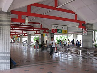
Pasir Ris Bus Interchange is a bus interchange located at Pasir Ris in the eastern part of Singapore. It is located off Pasir Ris Drive 3, adjacent to Pasir Ris MRT station and near White Sands Shopping Centre. This bus interchange also serves as a pick-up/drop-off point for shuttle buses ferrying NSF men heading to the SAF Ferry Terminal for their shuttle ferry to Pulau Tekong.

<span class="mw-page-title-main">Changi Beach Park</span>

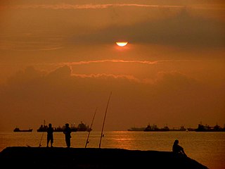
Changi Beach Park is a beach park located at the northern tip of Changi in the eastern region of Singapore.

<span class="mw-page-title-main">Future developments in Singapore</span>

This article shows the notable future developments in Singapore. Most of them are currently under construction with most to be completed within the next five years.

<span class="mw-page-title-main">North-East Region, Singapore</span> Region in Singapore

The North-East Region of Singapore is one of the five regions in the country. The region is the most densely populated and has the highest population among the five, with Sengkang being its most populous town as of 2020 and Seletar as the regional centre. Comprising 13,810 hectares, it includes seven planning areas and is largely a residential region with 217,120 homes. Housing largely consists of high-density HDB public housing estates, however private housing is also present in the region. As its name implies, it is located in the north-eastern part of Singapore.

<span class="mw-page-title-main">Tanah Merah, Singapore</span> Place in East Region, Singapore

Tanah Merah, is a geographical region located along the south-eastern coast of the East Region of Singapore. Although its boundaries are not exactly clear, it is widely accepted that the term refers to the southern coast of present-day Bedok, Tampines, Changi and Changi Bay.

Singapore has about 65 species of mammals, 390 species of birds, 110 species of reptiles, 30 species of amphibians, more than 300 butterfly species, 127 dragonfly species, and over 2,000 recorded species of marine wildlife.

<span class="mw-page-title-main">Coney Island, Singapore</span> Island in northeastern Singapore

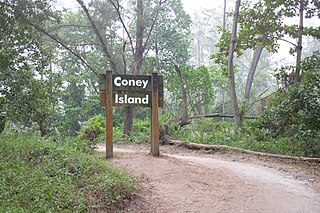
Coney Island, alternatively known as Pulau Serangoon, is a 133-hectare island located off the northeastern coast of Singapore within the town of Punggol, between Pulau Ubin to its northeast and the mainland to its southwest.

<span class="mw-page-title-main">Serangoon Harbour</span>

Serangoon Harbour is a harbour in Singapore located between the mainland island of Singapore and Pulau Ubin.

<span class="mw-page-title-main">Changi Boardwalk</span>

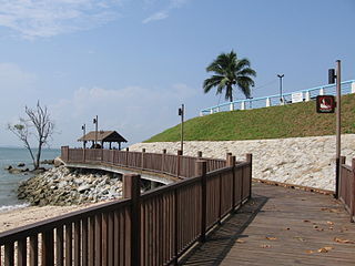
The Changi Boardwalk, also known as Changi Point Coastal Walk (樟宜尾沿岸木板路), is a 2.2 km boardwalk at Changi Point, Singapore.

<span class="mw-page-title-main">Changi Hospital</span> Hospital in Changi, Singapore

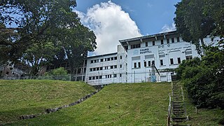
Changi Hospital is a now-defunct and abandoned general hospital located in Changi, Singapore. Its closure came with the merging with the former Toa Payoh Hospital and was renamed as the Changi General Hospital, which relocated new operations to nearby Simei, not far from Changi. It began winding down activities in February 1997 and remains abandoned to this day, but is off limits to the public.

References

  1. "British government bungalows". 2005. Archived from the original on 2018-04-23. Retrieved 2018-03-16.
  2. "Johore Battery". 2015. Retrieved 2018-03-16.
  3. "Eye on Changi Village: Eastern Village life". sg.news.yahoo.com. Retrieved 2022-12-16.
  4. "Changi Village area to be developed into sports and recreational centre". 2014-01-01. Retrieved 2018-03-16.
  5. "Changi Point: New eateries and hotels turn leafy sanctuary into rustic retreat". 2015-04-10. Retrieved 2018-03-16.
  6. "BNP Paribas Opens Asia Pacific Training & Development Campus in Singapore". 2014-03-11. Retrieved 2018-03-16.
  7. "Singapore Aviation Academy in Singapore - Master Degrees". Masterstudies. Retrieved 2020-09-02.
  8. "SCDF Organisation Structure". 2017. Archived from the original on 2018-03-13. Retrieved 2018-03-16.
  9. "Changi Village Bus Terminal" . Retrieved 2018-03-16.

1°23′N103°59′E / 1.383°N 103.983°E / 1.383; 103.983