
Jurong is a geographical region located at the south-westernmost point of the West Region of Singapore. Although mostly vaguely defined, the region's extent roughly covers the planning areas of Jurong East, Jurong West, Boon Lay, and Pioneer, along with Jurong Island in the Western Islands cluster and the southernmost portions of the Western Water Catchment. Should it be described at its greatest historical extent, the region can also include present-day Bukit Batok and Tuas as well. Jurong also covers several offshore islands as well, including Pulau Damar Laut and Pulau Samulun, both of which are located within the planning areas of Jurong East and Boon Lay respectively; along with the aforementioned Jurong Island. The coastline of the region on mainland Singapore, faces the strait of Selat Jurong, while the southernmost island of the region, Jurong Island, faces the strait of Selat Pandan.

Seletar is an area located in the north-east of Singapore. Its name can also refer to the Seletar Planning Area, situated in the North-East Region of Singapore. The place name was derived from the Malay subgroup who were indigenous to the area, the Orang Seletar. It shares boundaries with the planning areas of Sengkang to the south, Punggol to the east, Yishun and Simpang to the west, as well as the Straits of Johor to the north.

Jurong East is a planning area and residential town located in the West Region of Singapore. It borders Jurong West and Boon Lay to the west, Clementi to the east, Tengah and Bukit Batok to the north and Selat Jurong to the south.

Boon Lay, is a neighbourhood located in the town of Jurong West in the West Region of Singapore. Its borders very roughly correspond to the URA subzone of Boon Lay Place, situated within the Jurong West Planning Area.

Jurong West is a planning area and residential town located in the West Region of Singapore. Jurong West shares boundaries with Tengah in the north, Jurong East in the east, Boon Lay and Pioneer in the south, and Western Water Catchment in the west.
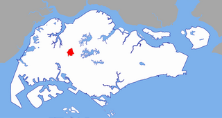
Bukit Gombak is a subzone of Bukit Batok, Singapore. It is a hilly neighbourhood in the west-central area of the Southeast Asian city-state of Singapore. In the Malay language, bukit means hill and gombak a bunch or collection of something. The neighbourhood consists of two hills. One of them stands at 133m while the other stands at 113m. They are Singapore's second and third highest natural point after Bukit Timah Hill.
Jurong West MRT station is a proposed Mass Rapid Transit (MRT) station on the Jurong Region Line in Jurong West, Singapore.

Yunnan is a subzone located in the town of Jurong West in the West Region of Singapore.

Jurong West Central is a subzone of Jurong West, located in the West Region of Singapore. This is the town centre of Jurong West.
SAFTI is a subzone of the Jurong West planning area of Singapore. It is home to the Pasir Laba Camp. It is also the training ground and a live-firing area for Singapore Armed Forces known as SAFTI Live Firing Area which is west of Pasir Laba Camp.
Wenya is a subzone of Jurong West, Singapore.
Yuhua is a subzone region located in the town of Jurong East, Singapore. Yuhua comprises two subzones, Yuhua East and Yuhua West. The area's HDB flats are under the management of Jurong-Clementi Town Council and the people of this precinct are represented in parliament by either Grace Fu or Rahayu Mahzam, depending on where they stay.
Brickworks is a subzone of Bukit Batok, Singapore. It is bounded by Bukit Batok West Avenue 3/2/5 and Bukit Batok Road and is beside the upcoming New Town, Tengah. It is the newest development area in Bukit Batok as there are new HDB being launched over the last few years.
Bukit Batok Central is a subzone of Bukit Batok. It is bounded by Bukit Batok West Avenue 6/3, Central, East Avenue 3/6.
Jurong Pier MRT station is a proposed Mass Rapid Transit (MRT) station on the Jurong Region Line, located on the boundary of Boon Lay and Jurong East planning areas in Singapore.
Jurong Hill MRT station is a proposed Mass Rapid Transit (MRT) station on the Jurong Region Line in Boon Lay, Singapore.
Tukang MRT station is a proposed Mass Rapid Transit (MRT) station on the Jurong Region Line in Boon Lay, Singapore. The name is derived from the road nearby, Jalan Tukang.
Enterprise MRT station is a proposed Mass Rapid Transit (MRT) station on the Jurong Region Line in Jurong West, Singapore.
Pandan Reservoir MRT station is a proposed Mass Rapid Transit (MRT) station on the Jurong Region Line in Jurong East, Singapore.
