Lavender, Singapore

Last updated
Lavender
Subzone of Kallang Planning Area
Other transcription(s)
   Chinese 劳明达
   Malay Lavender
   Tamil லவண்டர்
New World Gateway -Singapore, 2010.jpg
Immigration & Checkpoints Authority Building 3, Dec 05.JPG
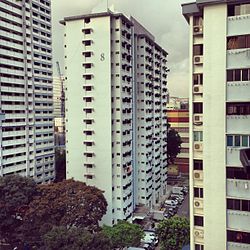
Lavender district HDB flats in Singapore.JPG
SG Residential buildings apartments high-rises Jun-2015 DSC Singapore night.JPG
Jalan Besar Stadium.JPG
Row 1: Gate of the old New World Amusement Park with City Square Mall in the background
Row 2: Immigration and Checkpoints Authority (ICA) Building
Row 3, left: Housing and Development Board (HDB) flats along King's George's Avenue
Row 3, right: Citylights condominiums
Row 4: Jalan Besar Stadium
CountryFlag of Singapore.svg  Singapore
Region Central Region
Planning Area Kallang

Lavender is a subzone within the planning area of Kallang, Singapore, as defined by the Urban Redevelopment Authority (URA). Lavender is composed of an area bounded by Tessensohn Road in the north; Balestier Road, Lavender Street and Crawford Street in the east; the Rochor River and Rochor Canal in the south; as well as Syed Alwi Road, Serangoon Road and Rangoon Road in the west. [1]

Lavender is largely commercial, even though several blocks of public housing provided by the Housing and Development Board (HDB) exist at Jellicoe Road and French Road. Notable places in this subzone include Jalan Besar Stadium, Jalan Besar Swimming Complex, Jalan Besar Community Club, the series of historic shophouses along Jalan Besar, the headquarters of People's Association, Immigration and Checkpoints Authority (ICA) Building, Sri Srinivasa Perumal Temple, Mustafa Centre, Umar Pulavar Tamil Language Centre and City Square Mall. In addition, the New World Amusement Park once stood in this area.

The district has not changed a lot in a city known for its frenetic urban planning, and as a source puts it, "entering Lavender is like entering Singapore in the late 1980s", [2] where old public housing is occupied by an elderly community, with small automotive shops, hardware resellers and temples.

A trend of gentrification began in around 2014, mainly along Jalan Besar. Parts of the Little India ethnic neighbourhood extends into this area. There are now many small coffee shops and music studios in this rather vintage-looking district.

Lavender MRT station and Farrer Park MRT station serve Lavender subzone.

Etymology

The subzone of Lavender derived its name from Lavender Street. The road was officially named on 8 March 1858, as a result of suggestions by the nearby residents. Contrary to what the name may suggest, the area around Lavender Street was foul-smelling, probably due to either the Kallang Gasworks in the vicinity, or the use of nightsoil as fertilizer at nearby farms. The name was suggested by residents of the area as tongue-in-cheek humour. [3]

Related Research Articles

<span class="mw-page-title-main">Kallang</span> Planning Area and HDB Town in Central Region ----, Singapore

Kallang is a planning area and residential zone located in the Central Region of Singapore.

Chinatown is a subzone and ethnic enclave located within the Outram district in the Central Area of Singapore. Featuring distinctly Chinese cultural elements, Chinatown has had a historically concentrated ethnic Chinese population.

<span class="mw-page-title-main">Jalan Besar</span> Place in Singapore

Jalan Besar is a one-way road in Singapore, connecting Lavender Street in Kallang and Rochor Canal Road in Rochor.

Tiong Bahru is a housing estate and subzone region located within Bukit Merah planning area, in the Central Region of Singapore. Tiong Bahru was constructed in the 1920s by the Singapore Improvement Trust, the predecessor to the Housing Development Board (HDB) and an entity of the British colonial authority providing mass public housing in Singapore and is the oldest housing estate in Singapore.

<span class="mw-page-title-main">Bukit Merah</span> Planning Area and HDB Town in Central Region ----, Singapore

Bukit Merah, also known as Redhill, is a planning area and new town situated in the southernmost part of the Central Region of Singapore. The planning area borders Tanglin to the north, Queenstown to the west and the Downtown Core, Outram and Singapore River planning areas of the Central Area to the east. It also shares a maritime boundary with the Southern Islands planning area to the south. Bukit Merah is linked to Sentosa Island via Sentosa Gateway, Sentosa Broadwalk, Sentosa Express and the Cable Car.

<span class="mw-page-title-main">Little India, Singapore</span> Subzone of Rochor Planning Area in Singapore

Little India is an ethnic district in Singapore. It is located east of the Singapore River – across from Chinatown, located west of the river – and north of Kampong Glam. Both areas are part of the urban planning area of Rochor. Little India is commonly known as Tekka in the Indian Singaporean community.

<span class="mw-page-title-main">Lavender MRT station</span> Mass Rapid Transit station in Singapore

Lavender MRT station is an underground Mass Rapid Transit (MRT) station on the East West line in Kallang, Singapore. Located under Kallang Road, the station is close to the Immigration and Checkpoints Authority (ICA) Building, the former Golden Mile Complex and Jalan Besar Stadium. Planned and built as part of Phase Two of the initial system. The contract for the station's construction was awarded in October 1985, and it was opened in November 1989.

<span class="mw-page-title-main">Tanjong Rhu</span> Subzone of Kallang Planning Area in Central Region

Tanjong Rhu is a subzone within the planning area of Kallang, Singapore, as defined by the Urban Redevelopment Authority (URA). The perimeter of Tanjong Rhu is made up of Nicoll Highway in the north; Mountbatten Road and Fort Road in the east; East Coast Parkway (ECP) in the south; as well as Marina Channel and Kallang Basin in the west. Tanjong Rhu is the largest in terms of physical area among the nine subzones that make up Kallang.

<span class="mw-page-title-main">Farrer Park</span> Subzone of Rochor Planning Area in Singapore

Farrer Park is a subzone of the Rochor planning area in the Central Region of Singapore, as defined by the Urban Redevelopment Authority bounded by Serangoon Road, Rangoon Road, Race Course Road, Northumberland Road, Tekka Lane and Bukit Timah Road.

<span class="mw-page-title-main">Rochor River</span> River in Singapore

The Rochor River is a canalised river in Kallang of the Central Region in Singapore. The river is about 0.8 km in length.

<span class="mw-page-title-main">Bukit Ho Swee</span> Subzone of Bukit Merah Planning Area in Central Region, Singapore

Bukit Ho Swee is a subzone within the planning area of Bukit Merah, Singapore, as defined by the Urban Redevelopment Authority (URA). Its boundary is made up of the Alexandra Canal in the north; Kim Seng Road and Outram Road in the east; Zion Road and Jalan Bukit Ho Swee in the south; Delta Road and Lower Delta Road in the west.

<span class="mw-page-title-main">Bendemeer MRT station</span> Mass Rapid Transit station in Singapore

Bendemeer MRT station is an underground Mass Rapid Transit (MRT) station on the Downtown line in Kallang, Singapore.

Kallang Bahru is a subzone within the planning area of Kallang, Singapore, as defined by the Urban Redevelopment Authority (URA). This subzone is bounded by Bendemeer Road and Sungei Whampoa in the north; the Kallang River in the east; Kallang Road and Sims Avenue in the south; and Lavender Street in the west.

<span class="mw-page-title-main">Geylang Bahru</span> Subzone of Kallang Planning Area in Central Region, Singapore

Geylang Bahru is a subzone within the planning area of Kallang, Singapore, as defined by the Urban Redevelopment Authority (URA). It is bounded by the Pan Island Expressway (PIE) in the east; the Pelton Canal in the south; the Kallang River in the west; and Serangoon Road in the north.

<span class="mw-page-title-main">Kaki Bukit, Singapore</span> Subzone of Bedok Planning Area in East Region, Singapore

Kaki Bukit is an industrial area located in Bedok in the East Region of Singapore. It is home to many high tech industrial companies and warehouses. There used to be a prison complex called Kaki Bukit Centre, which was converted to a prison school in 2000, however it has since moved to Tanah Merah and the Acacia Welfare Home now stands in its place. On the south of Kaki Bukit is Jalan Tenaga and Jalan Damai neighbourhoods of Bedok Reservoir Road. Redevelopments are in the pipeline for Kaki Bukit beyond 2030 when Paya Lebar Airbase located just north of the estate relocates to Changi. Not only would land be freed up for use but building height restrictions, that are currently in place for safety reasons because the estate is directly aligned with the airbase runway, would also be lifted. Kaki Bukit is classified by Urban Redevelopment Authority (URA) as a subzone under the planning area of Bedok, its boundaries differ from the constituency boundaries used by the Singapore Parliament.

<span class="mw-page-title-main">Rochor Centre</span>

Rochor Centre was a group of buildings in Singapore built by the Housing and Development Board. Dating back to the 1960s, there was an increasing number of people living in slum-like condition with poor sanitation due to the insufficient housing for Singapore's increasing population. Therefore, as part of the urban renewal program under the Housing and Development Board, Rochor Centre was built and completed in 1977 to take in residents and businesses that were uprooted across the city.

<span class="mw-page-title-main">Whampoa, Singapore</span> Housing zone in Balestier, Novena, Singapore

Whampoa is a housing estate located in the subzone of Balestier, which is a part of Novena planning area in Singapore, as defined by the Urban Redevelopment Authority. Within the context of the Housing and Development Board (HDB), however, Whampoa forms part of the Kallang/Whampoa New Town, together with the various housing precincts located in the adjacent Kallang planning area. This makes Kallang/Whampoa the only HDB new town that encompasses two planning areas, namely Novena and Kallang.

<span class="mw-page-title-main">Bendemeer, Singapore</span> Subzone of Kallang Planning Area in Central Region, Singapore

Bendemeer is a subzone within the planning area of Kallang, Singapore, as defined by the Urban Redevelopment Authority (URA). Its boundary is made up of the Pan Island Expressway (PIE) in the north; Serangoon Road, the Kallang River, Sungei Whampoa and Bendemeer Road in the east; Lavender Street and Balestier Road in the south; and the Central Expressway (CTE) in the west.

<span class="mw-page-title-main">Crawford, Singapore</span> Subzone of Kallang Planning Area in Central Region, Singapore

Crawford is a subzone within the planning area of Kallang, Singapore, as defined by the Urban Redevelopment Authority (URA). Its perimeter is made up of Rochor River and Rochor Canal in the north; Crawford Street, Nicoll Highway, Kallang Basin and Marina Channel in the east; East Coast Parkway (ECP) in the south; as well as Ophir Road, Beach Road and Jalan Sultan in the west.

Geylang East Public Library is one of the 26 public libraries established by the National Library Board of Singapore.

References

  1. "Singapore's Kallang Planning Area". Archived from the original on 12 May 2021. Retrieved 19 July 2018.
  2. "An intro to Singapore District & Area". www.streetdirectory.com.
  3. "Lavender Street | Infopedia". eresources.nlb.gov.sg.

1°17′54″N103°51′23″E / 1.2984°N 103.8564°E / 1.2984; 103.8564