Little India, Singapore

Last updated

Little India
Subzone of Rochor Planning Area
Singapore
Other transcription(s)
   Chinese 小印度
Xiǎo Yìndù(Pinyin)
Sió Ìn-tō͘(Hokkien POJ)
   Malay Little India
   Tamil சிறிய இந்தியா
Siṟiya intiyā(Transliteration)
Little India (4048444495).jpg
Shophouses in Little India
Singapore location map (main island).svg
Red pog.svg
Little India
Location of Little India within Singapore
Coordinates: 1°18′23″N103°51′06″E / 1.3065°N 103.8518°E / 1.3065; 103.8518
Country Singapore

Little India (Tamil : லிட்டில் இந்தியா) is an ethnic enclave in Singapore located east of the Singapore River, across from Chinatown, and north of Kampong Glam. [1] Little India is commonly known as Tekka among the Indian Singaporean community. [2]

Contents

History

Little India is a historical precinct in Singapore that took shape in the 19th century along Serangoon Road, where early watercourses and swamplands near the Rochor–Serangoon River corridor supported cattle bathing and fodder, drawing livestock trading and related occupations to the area.[1][2][3] European residents and facilities, including the mid‑1840s race course at what is now Farrer Park, anchored early settlement patterns, while Indian migrant workers employed in brick kilns and later in cattle rearing established enduring communities that gradually gave the district its **South Asian** character.[1][3][5]

Colonial era origins

Serangoon Road, marked on an 1828 town map as a “road leading across the island,” became an early arterial spine for movement and trade, making the surrounding low‑lying terrain practical for agro‑pastoral uses in the 19th century.[1][3] The area’s toponymy and landmarks—such as Dunlop and Clive streets reflecting European residents, and later references to cattle commerce—trace the layered colonial imprint on the neighbourhood’s growth.[1][2]

Cattle trade and settlement

From the 1840s, cattle trading expanded with access to water and grazing, attracting Indian specialists in rearing, transport, and butchery who formed occupational networks and small enterprises around Serangoon Road.[1][3] Figures associated with the trade, like I. R. Belilios, are memorialised in local street names, illustrating how commerce and community formation intertwined in the district’s early economy.[1][2]

Environmental change and demographic shift

With progressive drainage and reclamation of swamps in the late 19th and early 20th centuries, European cattle interests relocated, but Indian workers and traders remained, consolidating a predominantly Indian residential and commercial enclave.[2][1] By the early 20th century, the precinct’s identity reflected both its pastoral past and a growing concentration of South Asian religious, social, and mercantile institutions.[2][5]

Postwar transformation

In the decades after World War II, Serangoon Road and adjacent streets intensified as retail and services hubs serving Indian and wider communities, even as urban renewal targeted overcrowded housing in the broader area.[3][5] Heritage recognition and later conservation initiatives preserved significant shophouse streetscapes and historic urban form while accommodating commercial evolution.[5][1]

Naming and conservation

“Little India” became the prevailing name in the 1980s amid efforts to identify and promote Singapore’s historic ethnic districts for preservation and cultural tourism, reframing Serangoon’s long‑standing South Asian character within official discourse.[5][1] Subsequent heritage trails and interpretive programs codified the precinct’s historical narratives, emphasizing its 19th‑century origins, trade histories, and community institutions.[5][3]

Citations:

[1] Little India - Singapore - NLB https://www.nlb.gov.sg/main/article-detail?cmsuuid=5daa9fec-5726-4b74-af78-fed5ee468bdb

[2] Little India, Singapore - Wikipedia https://en.wikipedia.org/wiki/Little_India,_Singapore

[3] Once Upon a Time in Little India - Roots.sg https://www.roots.gov.sg/stories-landing/stories/Once-Upon-a-Time-in-Little-India

[4] Timeline of Singaporean history - Wikipedia https://en.wikipedia.org/wiki/Timeline_of_Singaporean_history

[5] Little India: A Cultural and Historical Precinct - Roots.sg https://www.roots.gov.sg/stories-landing/stories/little-india-a-cultural-and-historical-precinct/story

[6] A history of Singapore: a timeline of events - The Telegraph https://www.telegraph.co.uk/travel/discover-singapore/history-timeline/

[7] Experience the Culture and Charm of Little India Singapore https://www.gastrotravelogue.com/travel/destinations/asia/singapore/discovering-little-india-in-singapore/

Culture

Little India during Deepavali Deepavali, Little India, Singapore, Oct 06.JPG
Little India during Deepavali

Under the modern People’s Action Party (PAP) policy of racial integration, Little India is deemed as a historical landmark. Many Indian businesses and cottage industries remain concentrated in Little India for the purpose of preserving cultural heritage. However, Little India is not the only zone in Singapore with a significant South Asian population, and Indian-dominant commercial zones can also be found in various Housing and Development Board (HDB) estates.

Little India is also home to Chinese Clan Associations, places of worship for various religions, and a range of businesses, including those selling electrical supplies, hardware, second-hand goods, and traditional items such as spice grinders and groceries. [3]

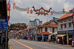
Little India is the center of Deepavali (Diwali) celebrations in Singapore. [4] [5] Since 1989, the Deepavali light-up has taken place along Serangoon Road, covering over two kilometers with decorative lights. The Indian Heritage Centre organizes the Deepavali Open House, which includes cultural performances, rangoli workshops, and bus tours of the decorated areas. [4] A seasonal bazaar, known as the Deepavali Festival Village, features stalls selling traditional clothing, food, and household items. Celebrations typically conclude on Deepavali day, with some activities continuing into early November. [6]

Features

Sri Veeramakaliamman Temple, Little India Sri Veeramakaliamman Temple, 2023 (02).jpg
Sri Veeramakaliamman Temple, Little India
Street in Little India Singapore little india 001 2002.jpg
Street in Little India

Serangoon Road is the main commercial thoroughfare in Little India. It intersects Rochor Canal Road and Bukit Timah Sungei Road. Along Serangoon Road are the Tekka Centre, the Tekka Mall, the Little India Arcade, Serangoon Plaza, and the Mustafa Centre (on a side road). Farrer Park Fields is located in the district. Several Hindu temples, mosques, and other places of worship include the Far Kor Sun Monkey God Temple, Foochow Methodist Church, Kampong Kapor Methodist Church (completed in 1929), Sri Veeramakaliamman Temple, Angullia Mosque, Sri Vadapathira Kaliamman Temple, Jalan Mosque, and the Central Sikh Gurdwara.

Leong San See Temple Leong San See Temple, 2012 0211.jpg
Leong San See Temple

The Sakya Muni Buddha Gaya Temple, along Racecourse Road, was established by a Thai monk, Venerable Vutthisasara, in 1927. [7] Leong San See Temple was built in 1917 and is dedicated to Guanyin, Bodhisattva of Compassion. [8]

Little India is also home to several art houses. In 1985, the National Arts Council launched the Arts Housing Scheme, aimed at identifying and renovating old buildings for arts and cultural activities. A line of shophouses along Kerbau Road were designated for the project, and the area is currently known as the Little India Arts Belt. As of 2011, there are seven arts organizations in the Belt. Three are contemporary theatre companies, while the other organizations involve traditional arts such as Malay dance and Indian theatre. [9]

Transport

The area is served by the MRT on the North East line (at Little India and Farrer Park) and Downtown line (at Rochor and Jalan Besar). Bus services 23, 64, 65, 67, 131, 139, 147, and 857 pass through Little India via Serangoon Road.

Panoramic view of Little India. Taken from Farrer Park View Housing Estate. Little India, Singapore, panorama, Aug 06.jpg
Panoramic view of Little India. Taken from Farrer Park View Housing Estate.
Panoramic view of Little India. Taken from Serangoon Road. Panoramic view of Serangoon Road, Little India, Singapore - 20080829.jpg
Panoramic view of Little India. Taken from Serangoon Road.

See also

References

  1. IndianDiaspora.org. "Little India of Singapore | Indian Diaspora". www.indiandiaspora.org. Retrieved 26 April 2025.
  2. "Conservation Portal -". www.ura.gov.sg. Retrieved 10 January 2024.
  3. Henderson, Joan C. (June 2008). "Managing Urban Ethnic Heritage: Little India in Singapore" . International Journal of Heritage Studies. 14 (4): 332–346. doi:10.1080/13527250802155851. ISSN   1352-7258.
  4. 1 2 "Indian Heritage Centre - Deepavali Open House 2024". www.indianheritage.gov.sg.
  5. "Deepavali Celebrations in Singapore 2025". www.visitsingapore.com.
  6. "Indian Heritage Centre - Discover Little India". www.indianheritage.gov.sg.
  7. "Sakya Muni Buddha Gaya Temple" . Retrieved 31 August 2023.
  8. "Leong San See Temple" . Retrieved 31 August 2023.
  9. TC, Chang (18 March 2014). "'New uses need old buildings': Gentrification aesthetics and the arts in Singapore" . Urban Studies. 53 (3): 524–539. doi:10.1177/0042098014527482. S2CID   145702075 . Retrieved 3 May 2022.