Marine Parade | |
---|---|
Other transcription(s) | |
• Simp. Chinese | 马林百列 |
• Trad. Chinese | 馬林百列 |
• Pinyin | Mǎlín Bǎiliè |
• Malay | Marine Parade |
• Tamil | மரின் பரேட் |
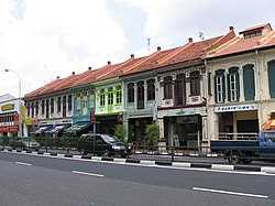
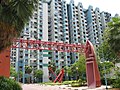
From top left to right: Panorama of East Coast Park, Marine Parade Promenade, Shophouses in Katong, Goodman Arts Centre, Katong Shopping Centre, Marine Parade Community Building, Marine Crescent Housing Estate, Tao Nan School | |
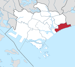
![]() Location in Central Region | |
Coordinates: 1°18′11″N103°54′28″E / 1.30306°N 103.90778°E | |
Country | ![]() |
Region | Central Region |
CDC | |
Town council |
|
Constituencies | |
Government | |
• Mayor | South East CDC |
• Members of Parliament | Marine Parade GRC Mountbatten SMC |
Area | |
• Total | 6.12 km2 (2.36 sq mi) |
Population | |
• Total | 46,690 |
• Density | 7,600/km2 (20,000/sq mi) |
Demonym | Official
|
Postal district | 15 |
Dwelling units | 7,862 |
Marine Parade is a planning area and residential estate located on the eastern fringe of the Central Region of Singapore. Straddling the tip of the southeastern coast of Pulau Ujong, Marine Parade serves as a buffer between the Central and East regions of the country. Bordering it are the planning areas of Geylang to the north, Kallang to the northwest, Bedok to the northeast, Marina East to the southwest and the Singapore Straits to the south.
Marine Parade is further divided into five subzones, East Coast, Katong, Marine Parade, Marina East (not to be confused with Marina East, the neighbouring planning area) and Mountbatten.
Marine Parade's early history can be associated with the precinct of Katong. Throughout the early to mid 20th century, the area was a haven for the wealthy Peranakan community of Singapore. Katong witnessed a growth in Straits Chinese culture, developing a distinctive architecture style and even becoming the place of origin for the renowned Katong Laksa dish. Marine Parade, as it is known today, mainly consists of HDB (Housing Development Board) flats along the southernmost points of the estate. These were built in the 1970s after the reclamation of the island's east coast. Today, many private condominiums are also being built in the area.
The main public housing estate comprises 58 blocks of HDB flats. The public estate is bisected by the arterial Still Road South that provides access to the major highway, East Coast Parkway, leading to the city area and to Singapore Changi Airport.
Marine Parade is served by two Mass Rapid Transit (MRT) stations on the Thomson–East Coast line, namely Marine Parade and Marine Terrace.
The Marine Parade Community Building was completed in 2000. It houses the Marine Parade Community Club and the Marine Parade Public Library. Other facilities within the three-storey complex include a 263-seater theatrette, a glass-walled gymnasium, a covered basketball court on the rooftop, an air-conditioned and a sports hall. The building has since been demolished, and is receiving a major upgrade. [4] [5]
Marine Parade, like other towns in Singapore, is served by a town centre. Dubbed Marine Parade Promenade, the centre itself consists of several neighbourhood shops, Parkway Centre and a commercial complex, Parkway Parade, that houses offices and a shopping mall.
As Marine Parade is primarily either recreational or residential, it is also a host to a variety of schools.
Marine Parade is a component division of the Marine Parade Group Representation Constituency, which also includes the Braddell Heights, Geylang Serai, Kembangan-Chai Chee and Joo Chiat divisions and elects five members to Singapore's Parliament. Singapore's former Prime Minister Goh Chok Tong is the Member of Parliament who represents the Marine Parade division since the formation until his retirement in 2020, where Minister Tan See Leng succeeded Goh as the MP.
Katong is a residential neighbourhood in the eastern portion of the Central Region of Singapore, within the Marine Parade planning area. The Katong district stretches from Fort Road area to the Joo Chiat area. It used to be located by the sea, before land reclamation towards the south to East Coast Park was created for housing and recreational purposes beginning in the 1960s to 1970s.
Geylang is a planning area and township located on the eastern fringe of the Central Region of Singapore, bordering Hougang and Toa Payoh in the north, Marine Parade in the south, Bedok in the east, and Kallang in the west.
Punggol is a planning area and new town situated on the Tanjong Punggol peninsula in the North-East Region of Singapore. The town directly borders Sengkang to the south and shares riverine boundaries with the planning area of Seletar to the west and Pasir Ris to the east. Bounding the town to the north and north-east is the Straits of Johor, with Coney Island included as a part of the Punggol planning area.
Kallang (IPA:/kɑːlɑːŋ/ is a planning area and residential zone located in the Central Region of Singapore.
Bedok is a planning area and residential town located in the geographical region of Tanah Merah along the south-eastern coast of the East Region of Singapore. Bedok is bounded by five other planning areas: Paya Lebar to the north, Hougang to the northwest, Tampines to the northeast and east, Geylang to the west and Marine Parade to the southwest. It also shares a maritime boundary with the Singapore Strait to the south and southeast.
Bukit Merah, also known as Redhill, is a planning area and new town situated in the southernmost part of the Central Region of Singapore. The planning area borders Tanglin to the north, Queenstown to the west and the Downtown Core, Outram and Singapore River planning areas of the Central Area to the east. It also shares a maritime boundary with the Southern Islands planning area to the south. Bukit Merah is linked to Sentosa Island via Sentosa Gateway, Sentosa Broadwalk, Sentosa Express and the Cable Car.
Siglap is a neighbourhood located south-west of Bedok in the East Region of Singapore. The area encompasses the Frankel and Opera Estates and their names have sometimes been used interchangeably to refer to the approximate same area. The planning subzone area of Siglap, as defined by the Urban Redevelopment Authority (URA), is confusingly and inaccurately referred to as the small strip of land between Victoria Junior College and Bedok South Avenue 1.
Christians in Singapore constitute 19% of the country's resident population, as of the most recent census conducted in 2020. Christianity is the second largest religion in the country, after Buddhism and before Islam. In 2020, about 37.1% of the country's Christians identified as Catholic with 62.9% labeled as 'Other Christians', most of which identify as Protestant, with some identifying as Orthodox or other minority Christian denominations.
Geylang East, as a planning subzone, covers what is more commonly known as Eunos. This is located in Geylang zone in the Central Region of Singapore. The vicinity is served by both Paya Lebar and Eunos MRT stations. This area is distinct from the Geylang East Central and estate, which is adjacent to and west of Eunos.
Tanjong Rhu, is a subzone within the planning area of Kallang, Singapore, as defined by the Urban Redevelopment Authority (URA). The perimeter of Tanjong Rhu is made up of Nicoll Highway in the north; Mountbatten Road and Fort Road in the east; East Coast Parkway (ECP) in the south; as well as Marina Channel and Kallang Basin in the west. Tanjong Rhu is the largest in terms of physical area among the nine subzones that make up Kallang.
This article shows the notable future developments in Singapore. Most of them are currently under construction with most to be completed within the next five years.
Joo Chiat Road is a road in Katong District and a residential conservation area located in the east coast of Singapore. Joo Chiat Rd intersect East coast Rd and Marine Parde Rd and end at Marine Parade Rd junction beside the new Marine Parade MRT station.
CHIJ Katong Convent is a government-aided autonomous Catholic girls' secondary school in Marine Parade, Singapore.
Fort Tanjong Katong, which stood from 1879 to 1901, was one of the oldest military forts built by the former British colonial government of Singapore. The fort gave its name to today's Fort Road, and it used to stand on the grounds of the present Katong Park. Fort Tanjong Katong, the only one of its kind on the eastern side of the island, was part of a series of defensive batteries and fortifications along the southern coast of Singapore, that defended the eastern approaches to the Singapore Harbour and Singapore Town against seaborne attacks. Due to its poor structural design and remoteness, the fort was subsequently abandoned and buried until its rediscovery in 2001. Found with traces of a moat and near intact perimeter wall, the fort was considered by local archaeological experts as one of Singapore's most important archaeological finds of a "true 19-century fort" to date. As a result, an archaeology group has been lobbying for the site to be gazetted as a National Monument. As of May 2010, the National Heritage Board has stated that it has no plans to gazette the fort for the time being.
Tanjong Katong Primary School is a government primary school, located on Seraya Road in Tanjong Katong, under Marine Parade Planning Area in the East Region of Singapore.
Teban Gardens is a residential precinct located in Jurong East, Singapore. Immediately north of Pandan Reservoir, it comprises exclusively public housing built by the JTC Corporation and Housing and Development Board.
Marine Parade MRT station is an underground Mass Rapid Transit (MRT) station on the Thomson–East Coast line (TEL) in Marine Parade, Singapore. Located underneath Marine Parade Road, the station serves nearby residential and commercial developments including Parkway Parade, Roxy Square and I12 Katong.
Marine Terrace MRT station is an underground Mass Rapid Transit station on the Thomson–East Coast line (TEL) at the boundary of the Marine Parade and Bedok planning areas in Singapore.
Tanjong Katong Complex is a shopping complex in Geylang Serai, Singapore. Completed in 1982, the complex was the first air-conditioned shopping complex built by the Housing and Development Board and has since become known for servicing the Malay community in the area.