Rochor

Last updated

Rochor
Other transcription(s)
   Chinese 梧槽
Wúcáo(Pinyin)
Ngô͘-chô(Hokkien POJ)
   Malay Rochor(Rumi)
   Tamil ரோச்சோர்
Rōccōr(Transliteration)
Aerial View of Rochor from 30 floors above (3871758586).jpg
Rochor Centre, Singapore - 20160402.jpg
City Campus of LASALLE College of the Arts, Singapore - 20080620.jpg
National Library, Singapore, 2008.jpg
Kampong Glam, Singapore.jpg
Bugis+ and Cheng Yan Court, Singapore - 20130119.jpg
Church of Our Lady of Lourdes 7, Jan 06.JPG
Bussorah Mall 2, Dec 05.JPG
Deepavali 15, Little India, Singapore, Oct 06.JPG
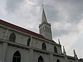
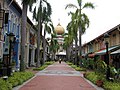
From top left to right: Aerial view of Rochor at night, Rochor Centre, LASALLE College of the Arts, National Library, Aerial view of Kampong Glam at night, Bugis+ and Cheng Yan Court, The Church of Our Lady of Lourdes, Masjid Sultan and Bussorah Mall, Little India
Rochor in Central Region, Singapore.svg
Location in Central Region
Singapore location map (main island).svg
Red pog.svg
Rochor
Location of Rochor within Singapore
Coordinates: 1°18′18.4″N103°51′3.2″E / 1.305111°N 103.850889°E / 1.305111; 103.850889
CountryFlag of Singapore.svg  Singapore
Region Central Region
CDC
Town council
  • Jalan Besar Town Council
Constituency
Government
  MayorCentral Singapore CDC
  Members of ParliamentJalan Besar GRC
Area
[1]
  Total
1.61 km2 (0.62 sq mi)
  Rank49th
Population
 (2024) [2]
  Total
12,920
  Rank29th
  Density8,000/km2 (21,000/sq mi)
   Rank24th
Demonym Official
  • Rochor resident
Postal district
07

Rochor ( IPA: /ˈr,-ɔːr/ ROH-choh or ROH-chor) is a planning area located within the Central Area of the Central Region of Singapore. Rochor shares boundaries with the following planning areas – Kallang to the north and east, Newton to the west, as well as Museum and the Downtown Core to the south.

Contents

Rochor has 10 subzones. These are Bencoolen, Farrer Park, Kampung Glam, Little India, Mackenzie, Mount Emily, Rochor Canal, Selegie, Sungei Road and Victoria.

Shopping centres

Rochor Planning Area panorama, October 2018 Rochor Canal Aerial Panorama October 2018.jpg
Rochor Planning Area panorama, October 2018

The Verge

The Verge, formerly Tekka Mall, is the first and largest modern shopping centre at Little India in Rochor, Singapore. It opened in 2003. The Verge has two buildings, the main building and Chill @ The Verge. It is located in the southern part of Little India, with the main building located on the junction of Serangoon Road and Sungei Road and the Chill @ The Verge located on the junction of Perak Road and Sungei Road. Both of the buildings are separated by Clive Road and the mall lies opposite Tekka Centre across Serangoon Road. On 16 July 2008, the mall was revamped, which also brought about the name change from Tekka Mall to The Verge. [3]

Tekka Centre

Tekka Centre is a relatively smaller shopping centre in Little India, Rochor. [4]

On the ground floor is a hawker centre with stalls which sell Indian vegetarian meals, served on banana leaves or on stainless steel platters, besides Chinese vegetarian, North Indian and Malay food.

At the wet market which is on the same level, stalls sell fresh seafood, especially crabs from Sri Lanka, and vegetables. There are also many Chinese stalls selling vegetables that are specially flown in from India.

MRT station

Rochor MRT station is a Mass Rapid Transit station on the Downtown line Stage 2 in Singapore, formerly known as the Bukit Timah line. The station links the East West line and the North East line along the Bukit Timah corridor, serving the commercial areas to the south of Little India. This station was originally planned to interchange itself but the plan was abandoned.

References

  1. Rochor (Planning Area, Singapore) – Population Statistics, Charts, Map and Location
  2. "Statistics Singapore - Geographic Distribution - Latest Data" . Retrieved 10 January 2025.
  3. "Tekka Mall" . Retrieved 2 October 2013.
  4. "Tekka Centre". VisitSingapore.com.