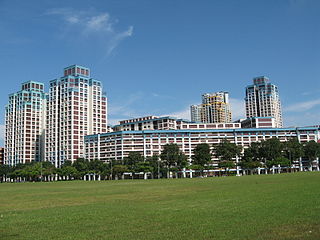
The Selective En bloc Redevelopment Scheme, or SERS for short, is an urban redevelopment strategy employed by the Housing and Development Board in Singapore in maintaining and upgrading public housing flats in older estates in the city-state. Launched in August 1995, it involves a small selection of specific flats in older estates which undergo demolition and redevelopment to optimise land use, as opposed to upgrading of existing flats via the Main Upgrading and Interim Upgrading Programmes. To date, 82 SERS sites have been announced, of which 77 were completed. The implementation of SERS also depends on the availability of replacement sites and the Government's financial resources. It will be replaced by Voluntary Early Redevelopment Scheme (VERS) in 20 years time.
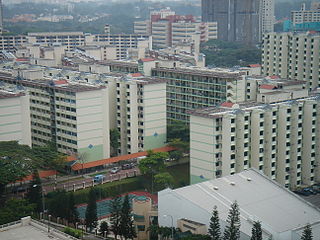
Only 4% of HDB flats have been identified for SERS since it was launched in 1995.[1] All residents displaced by the redevelopment works are offered a new 99-year lease in new flats constructed nearby. These residents have the privilege to select their units prior to public release of the remaining units, are compensated financially, and are given subsidised prices for their new flats. The scheme also gives residents the opportunity to continue living near their kin and neighbours, thereby retaining kinship bonds and strengthening community ties.
The Selective En bloc Redevelopment Scheme has attracted opposition and controversy. The national government has power, under the Land Acquisitions Act of 1966, to carry out the Selective En Bloc scheme.[2] This power invokes the principle of eminent domain as with most urban redevelopment projects.
In April 2020, to deal with the COVID-19 pandemic in foreign worker dormitories, it was announced that HDB blocks in Bukit Merah which had been purchased as part of the SERS would be used to temporarily house those foreign workers who were well and worked in critical services.[3][4]
The Central Region is one of the five regions in the city-state of Singapore and the main metropolitan region surrounding the Central Area. Comprising 13,150 hectares of land area, it includes 11 planning areas within the Central Area, as well as another 11 more outside it. The region is home to many of Singapore's national monuments as it was historically the site where the city was first founded and the country's only UNESCO World Heritage Site, the Singapore Botanic Gardens, a 165-year-old tropical garden is also located in the region.
The Housing & Development Board, is a statutory board under the Ministry of National Development responsible for the public housing in Singapore. Established in 1960 as a result of efforts in the late 1950s to set up an authority to take over the Singapore Improvement Trust's (SIT) public housing responsibilities, the HDB focused on the construction of emergency housing and the resettlement of kampong residents into public housing in the first few years of its existence.
Kallang is a planning area and residential zone located in the Central Region of Singapore.
Lim Chu Kang is a planning area located in the northwestern part of the North Region of Singapore, bordering the Western Water Catchment to the west and south, Sungei Kadut to the east and the Straits of Johor to the north.
Bukit Panjang is a planning area and residential town located in the West Region of Singapore. A portion of this town is situated on a low-lying elongated hill. The planning area is bounded by Bukit Batok to the west, Choa Chu Kang to the northwest, Sungei Kadut to the north, the Central Water Catchment to the east and Bukit Timah to the south. Bukit Panjang New Town is located at the northern portion of the planning area. Bukit Panjang has an average elevation of 36m/118 ft.
Queenstown is a planning area and satellite residential town situated on the south-westernmost fringe of the Central Region of Singapore. It borders Bukit Timah to the north, Tanglin to the northeast, Bukit Merah to the east and southeast, as well as Clementi to the northwest and west. Its southern and southwesternmost limits are bounded by the Pandan Strait.
Tiong Bahru is a housing estate located within the Bukit Merah Planning Area, in the Central Region of Singapore. Tiong Bahru was constructed in the 1920s by the Singapore Improvement Trust, the predecessor to the Housing Development Board (HDB) and an entity of the British colonial authority providing mass public housing in Singapore and is the oldest housing estate in Singapore. The main estate consists of 30 apartment blocks with over 900 units of two to five rooms that are also commonly referred to as "walk-ups". There are also high-rise HDB flats and condominiums along Boon Tiong Road, Jalan Membina and Kim Tian Road which surround the main estate.
Bedok is a planning area and residential town located in the geographical region of Tanah Merah along the south-eastern coast of the East Region of Singapore. Bedok is bounded by five other planning areas: Paya Lebar to the north, Hougang to the northwest, Tampines to the northeast and east, Geylang to the west and Marine Parade to the southwest. It also shares a maritime boundary with the Singapore Strait to the south and southeast.
Boon Lay is a neighbourhood located in the town of Jurong West in the West Region of Singapore. Its borders very roughly correspond to the URA subzone of Boon Lay Place, situated within the Jurong West Planning Area.
Lift Upgrading Programme (LUP) is a Singapore Housing and Development Board (HDB) project which upgrades and improves the facilities of the lifts at HDB flats. This project is for housing blocks built before the year 1996, which were built with lifts that only serve some floors to meet privacy demands and to cut costs. A poll with a 75% majority in favor is needed for the upgrading to begin. The non-citizen residents who stay in the same HDB block have no polling rights.
This article shows the notable future developments in Singapore. Most of them are currently under construction with most to be completed within the next five years.
Public housing in Singapore is subsidised, built, and managed by the Government of Singapore. Starting in the 1930s, the country's first public housing was built by the Singapore Improvement Trust (SIT) in a similar fashion to contemporaneous British public housing projects, and housing for the resettlement of squatters was built from the late 1950s. In the 1960s under the SIT's successor, the Housing and Development Board (HDB), public housing consisting of small units with basic amenities was constructed as quickly and cheaply as possible at high densities and used for resettlement schemes. From the late 1960s, housing programmes focused more on quality, public housing was built in new towns, and a scheme allowing residents to lease their flats was introduced. Throughout the 1970s and 1980s, more public housing options were provided for the middle class and efforts to increase community cohesion within housing estates were made. From the 1990s, the government began portraying public housing as an asset, introducing large-scale upgrading schemes and loosening regulations on the resale of public housing while additional housing programmes for the sandwich classes and elderly residents were introduced. Rising housing prices led to public housing being seen as an investment from the 2000s, and new technologies and eco-friendly features were incorporated into housing estates.
Hillview is located in Upper Bukit Timah, Northwest Singapore. The neighbourhood overlooks Bukit Timah Hill, hence its name.
Bukit Ho Swee is a subzone within the planning area of Bukit Merah, Singapore, as defined by the Urban Redevelopment Authority (URA). Its boundary is made up of the Alexandra Canal in the north; Kim Seng Road and Outram Road in the east; Zion Road and Jalan Bukit Ho Swee in the south; Delta Road and Lower Delta Road in the west.
Bukit Purmei is a small housing estate within Bukit Merah planning area in Singapore, near Telok Blangah estate. Bukit Purmei consists of 15 HDB blocks, private apartments and landed property.
Kaki Bukit is an industrial area located in Bedok in the East Region of Singapore. It is home to many high tech industrial companies and warehouses. There used to be a prison complex called Kaki Bukit Centre, which was converted to a prison school in 2000, however it has since moved to Tanah Merah and the Acacia Welfare Home now stands in its place. On the south of Kaki Bukit is Jalan Tenaga and Jalan Damai neighbourhoods of Bedok Reservoir Road. Redevelopments are in the pipeline for Kaki Bukit beyond 2030 when Paya Lebar Airbase located just north of the estate relocates to Changi. Not only would land be freed up for use but building height restrictions, that are currently in place for safety reasons because the estate is directly aligned with the airbase runway, would also be lifted. Kaki Bukit is classified by Urban Redevelopment Authority (URA) as a subzone under the planning area of Bedok, its boundaries differ from the constituency boundaries used by the Singapore Parliament.
Havelock MRT station is an underground Mass Rapid Transit station on the Thomson–East Coast line in the Bukit Merah planning area, Singapore. Spanning Zion Road, it serves Bukit Ho Swee residential estate and the historic Tiong Bahru estate, as well as Tan Boon Liat Building and Holiday Inn.
Dakota Crescent is one of Singapore’s oldest housing estates built by Singapore Improvement Trust (SIT), the government development authority, in 1958.
Tanglin Halt is a public housing estate, planning subzone and former industrial estate in Queenstown, Singapore. Most of the older buildings in the estate are set to be demolished by 2024 to make way for redevelopments under the Selective En bloc Redevelopment Scheme. It is the third housing estate to be redeveloped under the scheme.
Selegie House is a public housing complex which includes blocks 8-10 along Selegie Road in Singapore.
This page is based on this Wikipedia article Text is available under the CC BY-SA 4.0 license; additional terms may apply. Images, videos and audio are available under their respective licenses.