Neighbouring Areas
Neighbouring areas | ||||||||||||||||
|---|---|---|---|---|---|---|---|---|---|---|---|---|---|---|---|---|
| ||||||||||||||||
Gul Circle | |
|---|---|
Subzone of Pioneer Planning Area | |
| Name transcription(s) | |
| • Chinese | 卡尔圈 |
| • Pinyin | Kǎ'ěrquān |
| • Tamil | கல் சர்க்கல் |
| Coordinates: 1°19′22.0″N103°39′48.6″E / 1.322778°N 103.663500°E | |
| Country | Singapore |
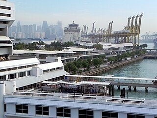
Gul Circle (or Gul) is an area in Jurong Industrial Estate which is the biggest industrial estate in Singapore. Gul is the home to many heavy industries in Singapore. It is bounded by Ayer Rajah Expressway (Jalan Ahmad Ibrahim), Benoi Road, Pioneer Road and Tuas Road. Tuas Fire Station is located at Gul as well.
The area is known as Tanjong Gul in the old maps of Singapore. [1]
Gul is served by SBS Transit industrial service 255 which links Gul to Joo Koon Bus Interchange and Joo Koon MRT station except Gul Road which is located in Pioneer Sector is served by industrial service 257 which also goes to Joo Koon Bus Interchange.
The below bus services run on the roads that form the boundary of Gul: 254 and 257 ply Benoi Road and Pioneer Road, 192 and 193 ply Jalan Ahmad Ibrahim and Tuas Road.
All the bus services above links the area to Joo Koon MRT station.
Gul Circle MRT station, which is located along Tuas Road, was opened on 18 June 2017. The MRT station opens simultaneously with the other stations of the East West line Tuas West Extension.
Neighbouring areas | ||||||||||||||||
|---|---|---|---|---|---|---|---|---|---|---|---|---|---|---|---|---|
| ||||||||||||||||

The East West line (EWL) is a high-capacity Mass Rapid Transit (MRT) line operated by SMRT, running from Pasir Ris station in the east to Tuas Link station in the west, with an additional branch between Changi Airport and Tanah Merah stations. It is the second Mass Rapid Transit line to be built in Singapore. The 57.2 kilometres (35.5 mi) line is the longest on the MRT network, with 35 stations, 8 of which are underground. The line is coloured green on the rail map.

Tuas is a planning area located within the West Region of Singapore. It is bounded by the Western Water Catchment to its north, Pioneer to its east and the Straits of Johor to its west. Tuas also shares a maritime boundary with the Western Islands planning area to its east.
Bukit Merah, also known as Redhill, is a planning area and new town situated in the southernmost part of the Central Region of Singapore. the planning area borders Tanglin to the north, Queenstown to the west and the Downtown Core, Outram and Singapore River planning areas of the Central Area to the east.

Jurong West is a planning area and residential town located in the West Region of Singapore. Jurong West shares boundaries with Tengah in the north, Jurong East in the east, Boon Lay and Pioneer in the south, and Western Water Catchment in the west.

Joo Koon MRT station is an above-ground Mass Rapid Transit (MRT) station along the East West Line in Pioneer planning area, Singapore.
Fernvale is a neighbourhood of Sengkang New Town in Singapore. It is located between Sungei Punggol and the proposed Sengkang West Industrial Estate. The house numbers of the public apartment blocks in Fernvale begin with the number '4' (4xx). Fernvale is the newest neighbourhood in Sengkang Town to be completed by the Housing and Development Board (HDB). Seletar Mall, a new shopping amenity which houses Sengkang's first cineplex, is located within this neighbourhood. In 2017, A proposed community facility to be located next to Seletar Mall was announced, which houses a community club, childcare centre, hawker centre and wet market. The community facility which was slated to be ready by the second half of 2020, had stopped construction in April 2020 due to the COVID-19 measures set by the government. Construction of the facility has since continued in the second half of 2020 and was completed in 2022.

Boon Lay Bus Interchange is an air-conditioned bus interchange located in Jurong West Central, in the western part of Singapore. It is situated within Jurong Point and integrated with the nearby Boon Lay MRT station. This interchange serves a variety of passengers, including those from Nanyang Technological University, Jurong Industrial Estate and Tuas Industrial Estate. The interchange has been among the largest and busiest bus interchanges in Singapore, handling 31 services in the past until a few services were amended to the newer Joo Koon Bus Interchange in 2015.
Pioneer Sector is part of the Jurong Industrial Estate which is the largest industrial estate in Singapore.
Joo Koon (裕群) is an industrial estate in Jurong of the West Region of Singapore. East of Joo Koon is Lok Yang and South is Gul. Joo Koon consists mostly of factories.
Benoi Sector is an industrial area in the Western region of Singapore within Jurong Industrial Estate. West of Benoi is Gul. East of Benoi is the Jurong Bird Park. Several Shipyards and oil refineries are located in the South of Benoi.
Wenya is a subzone of Jurong West, Singapore.

Jalan Ahmad Ibrahim is a road located in Boon Lay, Singapore. Named after Singaporean politician Ahmad Ibrahim, the road links Ayer Rajah Expressway with Jurong Hill Flyover.

The Joo Koon Bus Interchange is a bus transport facility located in Joo Koon, Singapore. Along with Joo Koon MRT station and FairPrice Hub, it is part of the Joo Koon Integrated Transport Hub (ITH). The facility is situated at the junction of Joo Koon Circle and Benoi Road, and located at the ground level of NTUC FairPrice's FairPrice Hub, next to Joo Koon MRT station. It is air conditioned and features glass walls for people to view the bus bay. The walls of the concourse is orange with a fusion of white. With three sawtooth boarding berths and eighteen parking lots, it is among the smallest bus interchanges in Singapore.

Gul Circle MRT station is an elevated Mass Rapid Transit (MRT) station on the East West line (EWL). Located in Tuas, western Singapore, the station serves the surrounding industries of JTC Space @ Tuas and Mapletree Pioneer Logistic Hub. The station is operated by SMRT Trains.

Tuas Crescent MRT station is an above-ground Mass Rapid Transit (MRT) station along the East West Line in Tuas, Singapore. This station is named after a road in the vicinity.

Tuas West Road MRT station is an above-ground Mass Rapid Transit (MRT) station along the East West line in Tuas, Singapore. This station took its name from a nearby road. It is located along Pioneer Road, near the junction with Tuas West Road, and sits along the boundaries of the Tuas North, Tuas Bay and Tuas Promenade planning subzones.
Kian Teck (建德) is an area in Jurong Industrial Estate in Singapore. It is in between Joo Koon and Boon Lay stations. It is home to many dormitories which houses foreign workers as well as factories and warehouses. Arena Country Club is also located within the industrial estate.
Chin Bee is an area in Jurong Industrial Estate in Singapore, bounded by Boon Lay Way, Jalan Boon Lay, Ayer Rajah Expressway and Corporation Road.
Pioneer is a planning area located in the West Region of Singapore, named after Pioneer Road, formerly Jalan Besi. The area is bounded by Jurong West to the north, Boon Lay to the east, Tuas to the west, the Western Water Catchment to the northwest and Selat Jurong to the south, and contains the Joo Koon, Benoi and Gul Circle industrial estates.
| | This Singapore location article is a stub. You can help Wikipedia by expanding it. |