
Protected areas of South Australia, consisting of protected areas located within South Australia and its immediate onshore waters and which are managed by South Australian Government agencies. As of 2018, South Australia contained 359 separate protected areas declared under the National Parks and Wildlife Act 1972, the Crown Land Management Act 2009 and the Wilderness Protection Act 1992. Together, they cover a total land area of 211,387.48 km2 (81,617.16 sq mi) or 21.5% of the state's area.
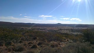
Gawler Ranges National Park is a 1,633 km2 (631 sq mi) protected area lying 350 km (217 mi) north-west of Adelaide in the northern Eyre Peninsula of South Australia. It is known for its spectacular rock formations.

Sentosa Island, known mononymously as Sentosa, is an island located off the southern coast of Singapore's main island. The island is separated from the main island of Singapore by a channel of water, the Keppel Harbour, and is adjacent to Pulau Brani, a smaller island wedged between Sentosa and the main island.

Mount Seymour is a mountain located in Mount Seymour Provincial Park in the District of North Vancouver, British Columbia, Canada. It is a part of the North Shore Mountains, rising to the north from the shores of Burrard Inlet and Indian Arm to a summit of 1,449 m (4,754 ft) above the Indian River and Deep Cove neighbourhoods. Mount Seymour is most commonly identified for its ski area of the same name, and as a popular hiking area. It is named in honour of Frederick Seymour, second governor of the Colony of British Columbia. The name is used to refer to the ridge although the main summit is one of several, and is also known as Third Peak.

The City of Kawartha Lakes is a unitary municipality in Central Ontario, Canada. It is a municipality legally structured as a single-tier city; however, Kawartha Lakes is the size of a typical Ontario county and is mostly rural. It is the second largest single-tier municipality in Ontario by land area.

The Gondwana Rainforests of Australia, formerly known as the Central Eastern Rainforest Reserves, are the most extensive area of subtropical rainforest in the world. Collectively, the rainforests are a World Heritage Site with fifty separate reserves totalling 366,500 hectares from Newcastle to Brisbane.

Canberra Airport is an international airport situated in the district of Majura, Australian Capital Territory. It serves Australia's capital city, Canberra, as well as the nearby city of Queanbeyan and regional areas of the Australian Capital Territory and southeastern New South Wales. Located approximately 8 km (5.0 mi) from the city centre, within the North Canberra district, it is the ninth-busiest airport in Australia.

Bishan, also known as Peck San, Bishan New Town or Bishan Town, is a planning area and matured residential town located at the northernmost portion of the Central Region of Singapore. Statistically, the area is ranked the 38th biggest in terms of geographical size and the 22nd most populated planning area in the country. It is located at the most Central point of Singapore, and it comprises Upper Thomson, Marymount, Shunfu, Sin Ming, Bishan North and Bishan East. There are also many private residential properties in Bishan. Bishan is ranked 15th in terms of population density. Apart from its boundary with the Central Water Catchment in the west, Bishan borders three other planning areas: Ang Mo Kio to the north, Toa Payoh to the south, and Serangoon to the east.

Jurong West is a planning area and residential town located in the West Region of Singapore. Jurong West shares boundaries with Tengah in the north, Jurong East in the east, Boon Lay and Pioneer in the south, and Western Water Catchment in the west.

Fort Canning Hill, or simply known as Fort Canning, is a prominent hill, about 48 metres (157 ft) high, in the southeast portion of Singapore, within the Central Area that forms Singapore's central business district.

Mount Faber, formerly Telok Blangah Hill, is a hill about 94 metres (308 ft) in height, located in the town of Bukit Merah in the Central Region of Singapore. It overlooks the Telok Blangah area and the western parts of the Central Area. The summit is accessible by Mount Faber Road or Mount Faber Loop via Morse Road, but there are many footpaths or trails leading up the hill. The main paths are: Marang Trail, which leads from Marang Road at the Harbourfront MRT station, and the Southern Ridges Park Connector which connects from Telok Blangah Hill Park, Kent Ridge Park, and Henderson Waves.

Imbiah Lookout is Singapore's biggest cluster of attractions, it is located in Sentosa Island. The area contains 11 attractions.

Universal Studios Singapore is a theme park located within the Resorts World Sentosa integrated resort at Sentosa in Singapore. It features 28 rides, shows, and attractions in seven themed zones. It is one of the five Universal Studios theme parks around the world.

Piccaninnie Ponds Conservation Park, formerly the Piccaninnie Ponds National Park, is a protected area of 862 hectares located in southeastern South Australia near Mount Gambier.

The wildlife of Singapore is surprisingly diverse despite its rapid urbanisation. The majority of fauna that remain on the island exist in nature reserves such as the Bukit Timah Nature Reserve and the Sungei Buloh Wetland Reserve.

Johor is a state of Malaysia in the south of the Malay Peninsula. It borders with Pahang, Malacca and Negeri Sembilan to the north. Johor has maritime borders with Singapore to the south and Indonesia to the east and west. As of 2023, the state's population is 4.09 million, making it the second most populous state in Malaysia, after Selangor. Johor Bahru is the capital city and the economic centre of the state, Kota Iskandar is the state administrative centre and Muar serves as the royal capital.

Mount Vernon Triangle is a neighborhood and community improvement district in the northwest quadrant of Washington, D.C. The neighborhood is located adjacent to Mount Vernon Square. Originally a working-class neighborhood established in the 19th century, present-day Mount Vernon Triangle experienced a decline in the mid-20th century as it transitioned from residential to commercial and industrial use.
Kulliparu Conservation Park is a protected area in the Australian state of South Australia located on the Eyre Peninsula in the gazetted localities of Colley, Karcultaby, Mount Cooper and Mount Damper about 59 kilometres (37 mi) west of the town centre in Kyancutta.
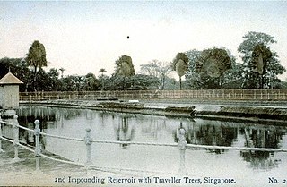
Mount Emily Reservoir was a reservoir originally designed to bring water supply to the town of Singapore. It was in operation from 1878 until it was not required with the completion of Fort Canning Reservoir in 1929. It was converted into a swimming pool and was reopened in 1931.
