
The Singapore Botanic Gardens is a 165-year-old tropical garden located at the fringe of the Orchard Road shopping district in Singapore. It is one of three gardens, and the only tropical garden, to be honoured as a UNESCO World Heritage Site. The Botanic Gardens has been ranked Asia's top park attraction since 2013, by TripAdvisor Travellers' Choice Awards. It was declared the inaugural Garden of the Year by the International Garden Tourism Awards in 2012.

Ang Mo Kio is a planning area and residential town situated in the North-East region of Singapore. Located approximately 11 km (6.8 mi) north of the Downtown Core district, Ang Mo Kio is the 3rd most populated planning area in the North-East region and ranks 8th in terms of population in the country overall. The planning area is located at the south-western corner of the North-East region, bordered by the planning areas of Yishun to the north, Sengkang to the north-east, Serangoon to the east, Bishan to the south and the Central Water Catchment to the west.

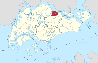
Sembawang is a planning area and residential town located in the North Region of Singapore. Sembawang planning area is bordered by Simpang to the east, Mandai to the south, Yishun to the southeast, Woodlands to the west and the Straits of Johor to the north.

Punggol is a planning area and new town situated on the Tanjong Punggol peninsula in the North-East Region of Singapore. The town directly borders Sengkang to the south and shares riverine boundaries with the planning area of Seletar to the west and Pasir Ris to the east. Bounding the town to the north and north-east is the Straits of Johor, with Coney Island included as a part of the Punggol planning area.

Yishun, formerly known as Nee Soon, is a residential town located in the northeastern corner of the North Region of Singapore, bordering Simpang and Sembawang to the north, Mandai to the west, the Central Water Catchment to its southwest, Ang Mo Kio to its south, as well as Seletar and Sengkang to its east and southeast respectively.
Seletar is an area located in the north-east of Singapore. Its name can also refer to the Seletar Planning Area, situated in the North-East Region of Singapore. The place name was derived from the Malay subgroup who were indigenous to the area, the Orang Seletar. It shares boundaries with the planning areas of Sengkang to the south, Punggol to the east, Yishun and Simpang to the west, as well as the Straits of Johor to the north.

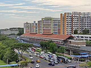
Sembawang MRT station is an elevated Mass Rapid Transit (MRT) station on the North–south line (NSL). Located in Sembawang, Singapore along Sembawang Road, the station is close to the Sun Plaza shopping centre and Sembawang Bus Interchange. The station is operated by SMRT Trains.
The North Region of Singapore is one of the five regions in the city-state. The region is the second largest region in terms of land area, and has a population of 582,330. Woodlands is the regional centre and also the most populous town with 255,130 residents living in the area. Comprising 13,500 hectares of land area, it includes eight planning areas.

Pasir Ris Park is a beach park located in the eastern part of Singapore. It covers an area of 70 hectares, and was partially built on reclaimed land. Initially planned in the late 1970s to serve people living in the vicinity, the park was designed with the help of two Japanese landscape specialists. Construction began on the park in September 1984, and the park was opened in phases from August 1986 to 1991. The park was further expanded in 2007, with the addition of new areas such as a herb garden.

Northpoint City, formerly known as Northpoint Shopping Centre, is a suburban shopping mall in Yishun, Singapore. Located opposite Yishun MRT station, the mall houses the Nee Soon Central Community Club, Yishun Public Library as well as the Yishun Bus Interchange, which forms part of the Yishun Integrated Transport Hub (ITH).

This article shows the notable future developments in Singapore. Most of them are currently under construction with most to be completed within the next five years.

Chinese Garden is a park in Jurong East, Singapore. Built in 1975 by the JTC Corporation and designed by Prof. Yuen-chen Yu, an architect from Taiwan, the Chinese Garden's concept is based on Chinese gardening art. The main characteristic is the integration of architectural features with the natural environment. The Chinese Garden is modeled along the northern Chinese imperial style of architecture and landscaping. It is located next to Chinese Garden MRT station and connected to the adjacent Japanese Garden by a bridge. Along with Japanese Garden, the two gardens are collectively known as the Jurong Gardens.

The Southern Ridges comprise 10 kilometres (6.2 mi) of trails connecting three parks along the southern ridge of Singapore. Some of the attractions along these trails include its greenery and the connecting bridges. This project linked up the parks between the Kent Ridge Park and HarbourFront. The idea to link these parks was coined in 2002 by Urban Redevelopment Authority (URA) and it took 2 years to complete and cost S$25.5 million.
West Coast Park is a large regional park located at the south-western corner of West Coast, Singapore. It runs parallel to West Coast Highway, and covers an area of roughly 50 hectares of park land consisting of three areas, each with its own variety of activities promising to ensure a fun-filled day for visitors both young and old. Since its inception, the park has been themed as the "Play Centre in the West".

Sengkang Riverside Park is a riverine park located at Anchorvale Street and Fernvale Street abutting Sungei Punggol, Singapore. The park consist of three open-space land parcels and is also home to a constructed wetland. The Sengkang Sports Centre is located just adjacent to the riverine park, connected by a floating wetland, Sengkang Floating Wetland.
Chong Pang is a housing estate located in the subzone of Yishun West along the Sembawang–Yishun boundary in the town of Yishun, Singapore. It was named after the former Chong Pang village. It has precincts of Neighbourhood 1, part of Neighbourhood 7 and private residential areas along Sembawang Road.
Yishun Pond Park is an urban park located at Yishun, Singapore. It is situated along Yishun Central in front of Khoo Teck Puat Hospital and connects the residential areas to Yishun MRT station and Northpoint Shopping Centre.
Sungei Simpang Kiri is a river located in eastern part of Sembawang, Singapore. The river starts near Canberra Link and discharges into the Straits of Johor.
Khatib is a subzone of Yishun, Singapore. It is bounded by Yishun Avenue 1/2/3 to the south, east and north respectively, and Sembawang Road to the west.
