
Sembawang is a planning area and residential town located in the North Region of Singapore. Sembawang planning area is bordered by Simpang to the east, Mandai to the south, Yishun to the southeast, Woodlands to the west and the Straits of Johor to the north.
Woodlands is a planning area and residential town located in the North Region of Singapore. As of 2019, the town has a population of 254,733. Located approximately 25 km north of the central business district (CBD), it is the densest planning area and the regional centre for the northern parts of the country.
Clementi is a planning area and residential town located at the easternmost fringe of the West Region of Singapore. The town borders Bukit Batok to the north, Bukit Timah to the northeast, Queenstown to the east and Jurong East to the west.

Tampines is the regional centre of the East Region of Singapore. With a population of 284,560 living across its five subzones as of 2024, it is the most populous planning area in Singapore. It is home to approximately 5% of Singapore's population. Tampines is bordered to the west by Bedok and Paya Lebar, to the north by Pasir Ris, to the east by Changi, and to the south by the Straits of Singapore. Situated in the historical region of Tanah Merah, its present-day terrain is particularly flat due to the large-scale sand quarrying in the 1960s.

Yishun, formerly known as Nee Soon, is a residential town located in the northeastern corner of the North Region of Singapore, bordering Simpang and Sembawang to the north, Mandai to the west, the Central Water Catchment to its southwest, Ang Mo Kio to its south, as well as Seletar and Sengkang to its east and southeast respectively.

Bukit Panjang is a planning area and residential town located in the West Region of Singapore. A portion of this town is situated on a low-lying elongated hill. The planning area is bounded by Bukit Batok to the west, Choa Chu Kang to the northwest, Sungei Kadut to the north, the Central Water Catchment to the east, and Bukit Timah to the south. Bukit Panjang New Town is located at the northern portion of the planning area. Bukit Panjang has an average elevation of 36m/118 ft.

The history of the Mass Rapid Transit (MRT) system of Singapore commenced with its planning in the 1960s, which finally led to its opening in 1987 with the launch of a 6 km section of the North–South Line (NSL) from Yio Chu Kang to Toa Payoh. Since its inception, the rapid transit system has played a crucial role in the public transportation network and the wider development of the country as a whole, providing a fast and efficient means of transportation for millions of Singaporeans daily.

Rail transport in Singapore mainly consists of a passenger urban rail transit system spanning the entire city-state: a rapid transit system collectively known as the Mass Rapid Transit (MRT) system operated by the two biggest public transport operators SMRT Trains and SBS Transit, as well as several Light Rail Transit (LRT) rubber-tyred automated guideway transit lines also operated by both companies. In addition, local specialised light rail lines are in operation in places such as the Singapore Changi Airport and Sentosa.

Sembawang Bus Interchange is a bus interchange located in Sembawang, Singapore. Opened on 20 November 2005, it provides hassle-free transfer to the nearby Sembawang MRT station.
Admiralty is a subzone of the planning area of Sembawang, in the north of Singapore.

This article shows the notable future developments in Singapore. Most of them are currently under construction with most to be completed within the next five years.

The North-East Region of Singapore is one of the five regions in the country. The region is the most densely populated and has the highest population among the five, with Sengkang being its most populous town as of 2020 and Seletar as the regional centre. Comprising 13,810 hectares, it includes seven planning areas and is largely a residential region with 217,120 homes. Housing largely consists of high-density HDB public housing estates, however private housing is also present in the region. As its name implies, it is located in the north-eastern part of Singapore.

The Museum Planning Area is a planning area located in the Central Area of the Central Region of Singapore. The area plays a "bridging role" between the Orchard area and the Downtown Core, which necessitates proper transport networks for vehicles, pedestrians and public transport. Due to the sheer size of green areas in the district, the Urban Redevelopment Authority (URA) has designated it a 'green lung' in the Central Area. However, the Museum Planning Area is also home to cultural and commercial activities. Around 65% of the area is available for future development, making it a hotbed for new infrastructure and buildings.
Taman Jurong is a residential precinct in Jurong West, Singapore. It is one of the oldest residential precincts in Singapore and a division of Jurong GRC, with the area's HDB flats under the management of Jurong-Clementi Town Council and Shawn Huang as the area's MP.

Woodlands Train Checkpoint is a railway station and border checkpoint in Woodlands, Singapore. Located close to the Malaysia–Singapore border, the station is owned by Singapore's Immigration and Checkpoints Authority (ICA) and is operated by the Malaysian railway operator Keretapi Tanah Melayu (KTM) in agreement with the Singaporean authorities.

Jurong Lake District (JLD) is a district of Singapore, planned as part of Urban Redevelopment Authority (URA)’s decentralisation efforts to bring more quality jobs, amenities, and recreational options closer to homes. The plans for the district have continued to evolve since the blueprint was first unveiled in the URA Master Plan 2008. It consists of three precincts, namely Jurong Gateway, Lakeside and Lakeside Gateway. It is 472 hectares (4,720,000 m2) in size and served by two major expressways and three MRT stations. It is planned to be Singapore's next central business district. In June 2023, a white site 6.5 hectares (ha) in size was released for sale to kick-start development of the largest commercial district outside Singapore’s city centre.
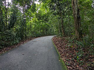
Dairy Farm Nature Park is a 63-hectare nature park located at 100 Dairy Farm Road, Upper Bukit Timah in the west side of Singapore. Dairy Farm Nature Park is known as a recreational area that offers a variety of attractions for visitors to explore. Some of the more notable attraction of the park includes the Singapore Quarry and Dairy Farm Quarry, both of which will enhance the unique opportunities for outdoor activities and appreciation of the nature environment in Singapore. Singapore Quarry is one of the two quarries that is located in Dairy Farm Nature Park where visitors can spot dragon files and even birds while admiring the scenic lake view. Meanwhile, Dairy Farm Quarry offers an experience of the region's geological history and it is surrounded by lush greenery and even rock cliffs. With these two quarries at the park, it will definitely contribute to the park's appeal for visitors to explore and hike.

Bukit Batok Town Park is a nature park located in the precinct of Guilin in the town of Bukit Batok, Singapore. The park was created from a disused granite quarry. As such, it has a resemblance to the granite rock formations in Guilin, China. Hence it is also known as Little Guilin or Xiao Guilin among the Chinese.

Kallang Riverside Park is a riverine park in Kallang, Singapore. It sits on the confluence of the Kallang River and Rochor River, north of the Kallang Basin.

