
Changi is a planning area located in the geographical region of Tanah Merah in the East Region of Singapore. Sharing borders with Pasir Ris and Tampines to the west, Changi Bay to the southeast, the South China Sea to the east and the Serangoon Harbour to the north. Changi, excluding the two water catchments and islands of Singapore, is the largest planning area by land size.

Tomoyuki Yamashita was a Japanese convicted war criminal and general in the Imperial Japanese Army during World War II. Yamashita led Japanese forces during the invasion of Malaya and Battle of Singapore. His conquest of Malaya and Singapore in 70 days earned him the sobriquet "The Tiger of Malaya" and led to the British Prime Minister Winston Churchill calling the ignominious fall of Singapore to Japan the "worst disaster" and "largest capitulation" in British military history. He was assigned to defend the Philippines from the advancing Allies later in the war. Although he was unable to prevent the superior Allied forces from advancing, despite dwindling supplies and Allied guerrilla action, he was able to hold on to part of Luzon until after the formal Surrender of Japan in August 1945.

Sook Ching was a mass killing that occurred from 18 February to 4 March 1942 in Singapore after it fell to the Japanese. It was a systematic purge and massacre of 'anti-Japanese' elements in Singapore, with the Singaporean Chinese particularly targeted by the Japanese military during the occupation. However, Japanese soldiers engaged in indiscriminate killing, and did not try to identify who was 'anti-Japanese.'

Pungool is a planning area and new town situated on the Tanjong Pungool peninsula in the North-East Region of Singapore. The town directly borders Sengkang to the south and shares riverine boundaries with the planning area of Seletar to the west and Pasir Ris to the east. Bounding the town to the north and north-east is the Straits of Johor, with Coney Island included as a part of the Punggol planning area.

Kallang is a planning area and residential zone located in the Central Region of Singapore.
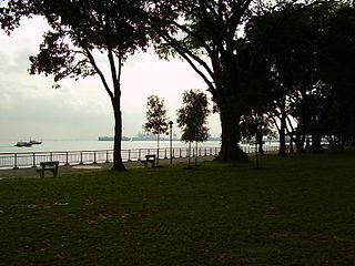
Changi Village is a modern village situated at the northern tip of Changi which is at the eastern end of Singapore. It is the usual connecting point for travellers heading to Pulau Ubin or Malaysia by ferry. Fishermen in the kelongs located in the Serangoon Harbour offshore also use this jetty as a drop off point to come onto mainland. Changi Village also has many resorts and leisure facilities to cater for a weekend getaway for many Singaporeans. The area is classified by Urban Redevelopment Authorities as under the planning area of Changi and in the subzone of Changi Point. It is also classified under District 17 for property indexing.
Syonan, officially Syonan Island, was the name for Singapore when it was occupied and ruled by the Empire of Japan, following the fall and surrender of British military forces on 15 February 1942 during World War II.
Malaya, then under British administration, was gradually occupied by Japanese forces between 8 December 1941 and the Allied surrender at Singapore on 15 February 1942. The Japanese remained in occupation until their surrender to the Allies in 1945. The first Japanese garrison in Malaya to lay down their arms was in Penang on 2 September 1945 aboard HMS Nelson.

Changi Beach Park is a beach park located at the northern tip of Changi in the eastern region of Singapore.
Sembawang Park is a 15-hectare park situated in Sembawang, in the north of Singapore facing the Straits of Johor overlooking Malaysia. It is located at the end of Sembawang Road, where the former Sembawang Road End Bus Terminal was.
The Memorial to the Civilian Victims of the Japanese Occupation, usually called the Civilian War Memorial, is a war memorial and heritage landmark in Singapore next to Esplanade MRT station. It was built in memory of the civilians killed during the Japanese occupation of Singapore during World War II. The Civilian War Memorial sits on serene parkland in the midst of busy city traffic near Singapore's Padang and City Hall. Located within the War Memorial Park at Beach Road within the Central Area, Singapore's central business district, it is usually easy to spot in most backdrops encompassing the CBD landscape. It was gazetted as the 65th national memorial on 15 August 2013.
Labrador Nature Reserve, also known locally as Labrador Park, is located in the southern part of mainland Singapore. It is home to the only rocky sea-cliff on the mainland that is accessible to the public. Since 2002, 10 hectares of coastal secondary-type vegetation and its rocky shore have been gazetted as a nature reserve and its flora and fauna preserved by NParks.

Serangoon Harbour is a harbour in Singapore located between the mainland island of Singapore and Pulau Ubin.
Dalforce, officially the Singapore Overseas Chinese Anti-Japanese Volunteer Army was an irregular forces/guerrilla unit within the British Straits Settlements Volunteer Force during World War II. Its members were recruited among the ethnic Chinese people of Singapore. It was created on 25 December 1941 by Lieutenant Colonel John Dalley of the Federated Malay States Police Force. The unit was known to the British colonial administration as Dalforce, after its chief instructor and commanding officer, John Dalley, whereas the Chinese in Singapore only knew it as the Singapore Overseas Chinese Anti-Japanese Volunteer Army. This formation took part in the Battle of Singapore and some members conducted a guerrilla campaign against Japanese forces during the Japanese occupation. The British noted how ferociously the Chinese volunteers in Dalforce fought, earning them the nickname Dalley's Desperadoes.

Mamoru Shinozaki was a journalist for Dentsu and spy for the Ministry of Foreign Affairs in pre-war years, a military executive in Japanese-occupied Singapore, and a businessman and writer in post-war years. He is known for the Shinozaki Case in 1940, and for his testimony in the war crimes trial in 1947 for the Sook Ching massacre.

Kent Ridge Park is a 47-hectare public park located in Kent Ridge, Singapore, between the National University of Singapore and the Singapore Science Park. Due to its undisturbed habitat and abundant plant life, it is a popular venue for bird-watchers and eco-tourists.

The Kempeitai East District Branch was the headquarters of the Kempeitai, the Japanese military police, during the Japanese occupation of Singapore from 1942 to 1945. It was located at the old YMCA building, at the present site of Singapore's YMCA Building on Stamford Road. Opened in 1911, the distinctive Art Deco YMCA building was the site of interrogation and torture of many innocent civilians, including the war heroine Elizabeth Choy. After the war, the Singapore government erected several memorials with some at the former massacre sites. In 1995, the former site of the old YMCA building was gazetted by the National Heritage Board as one of the eleven World War II sites of Singapore.
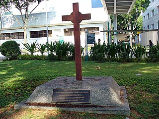
The SGH War Memorial is located within the grounds of the Singapore General Hospital (SGH) in Outram. This memorial marked the tragedy and the burial site of a group of medical students from the King Edward VII College of Medicine, who were killed during the Second World War in Singapore. In 2005, the memorial, along with eight other historic sites of SGH, was incorporated as part of the Outram Campus Heritage Trail that allow visitors to explore the important historical landmarks that are closely linked with the history of medical education in Singapore.

War Memorial Park is a park in Singapore, located at the junctions of Beach Road, Stamford Road, Nicoll Highway and Bras Basah Road in the Downtown Core of Singapore's Central Region next to Esplanade MRT station. The Civilian War Memorial is located at the center of the park as a memorial to civilians who died in the Japanese occupation of Singapore during World War II. It is managed by the National Parks Board.

The Ayer Itam War Memorial Park is a war memorial in George Town within the Malaysian state of Penang. Located at the suburb of Ayer Itam, the memorial commemorates the local Chinese who lost their lives during the Second Sino-Japanese War and the subsequent Japanese occupation of Malaya. The memorial was unveiled in 1951, with additional upgrades completed in 2011.

