
Kallang is a planning area and residential town located in the Central Region of Singapore.
Chinatown is a subzone and ethnic enclave located within the Outram district in the Central Area of Singapore. Featuring distinctly Chinese cultural elements, Chinatown has had a historically concentrated ethnic Chinese population.
Tiong Bahru is a housing estate located within the Bukit Merah Planning Area, in the Central Region of Singapore. Tiong Bahru was constructed in the 1920s by the Singapore Improvement Trust, the predecessor to the Housing Development Board and an entity of the British colonial authority providing mass public housing in Singapore and is the oldest housing estate in Singapore. The main estate consists of 30 apartment blocks with over 900 units of two to five rooms. There are also high-rise Housing and Development Board (HDB) flats and condominiums along Boon Tiong Road, Jalan Membina and Kim Tian Road which surround the main estate.

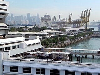
Tanjong Pagar is a historic district located within the Central Business District in Singapore, straddling the Outram Planning Area and the Downtown Core under the Urban Redevelopment Authority's urban planning zones.
Bukit Merah, often abbreviated as Bt Merah, is a planning area and new town situated in the southernmost part of the Central Region of Singapore. The planning area borders Tanglin to the north, Queenstown to the west and the Downtown Core, Outram and Singapore River planning areas of the Central Area to the east. Bukit Merah also shares a maritime boundary with the Southern Islands planning area located beyond its southernmost point. Bukit Merah is the most populated planning area in the Central Region, and the 12th most populated planning area in the country overall, being home to more than 150,000 residents.

The Downtown Core is the historical and downtown centre of the city-state of Singapore and the main commercial area in Singapore excluding reclaimed lands with many integrated resorts such as the Marina Bay Sands, one of the most expensive buildings in the world, with the most expensive standalone casino at Bayfront Avenue. There are many skyscrapers in Raffles Place, Tanjong Pagar and Marina Bay CBD with a height limit of 280m. It is one of the eleven planning areas located within the most urbanised Central Area, forming the latter's dense urban core. It is bounded by Rochor to the north, Kallang to the northeast, Marina East and Marina South to the east, Straits View to the southeast, Bukit Merah to the south, as well as Outram, Museum and Singapore River to the west.
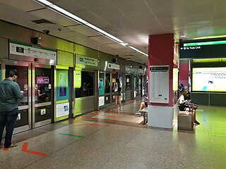
Tanjong Pagar MRT station is an underground Mass Rapid Transit (MRT) station on the East West line located at Maxwell Road between the junctions of Peck Seah Street and Cecil Street in Downtown Core, Singapore. The station was built in the 1980s, and was opened in December 1987. Taking its name from Tanjong Pagar Road, which is located near the station, it is located near Tanjong Pagar Complex, the AXA Tower and International Plaza.

Rail transport in Singapore mainly consists of a passenger urban rail transit system spanning the entire city-state: a rapid transit system collectively known as the Mass Rapid Transit (MRT) system operated by the two biggest public transport operators SMRT Trains and SBS Transit, as well as several Light Rail Transit (LRT) rubber-tyred automated guideway transit lines also operated by both companies. In addition, local specialised light rail lines are in operation in places such as the Singapore Changi Airport and Sentosa.

The architecture of Singapore displays a range of influences and styles from different places and periods. These range from the eclectic styles and hybrid forms of the colonial period to the tendency of more contemporary architecture to incorporate trends from around the world. In both aesthetic and technological terms, Singapore architecture may be divided into the more traditional pre-World War II colonial period, and the largely modern post-war and post-colonial period.

Tanjong Pagar railway station, also called Singapore railway station or Keppel Road railway station, is a former railway station located at 30 Keppel Road in Singapore. The station was the southern terminus of the network operated by Keretapi Tanah Melayu (KTM), the main railway operator in Malaysia, until 30 June 2011 when the station ceased operations with relocation of the KTM station to Woodlands Train Checkpoint. The land on which the station and the KTM railway tracks stood was originally owned by KTM and over which Malaysia had partial sovereignty. This arrangement lasted until 30 June 2011, when rail service to Tanjong Pagar was ended and the land reverted to Singapore.

Tanjong Rhu is a subzone within the planning area of Kallang, Singapore, as defined by the Urban Redevelopment Authority (URA). The perimeter of Tanjong Rhu is made up of Nicoll Highway in the north; Mountbatten Road and Fort Road in the east; East Coast Parkway (ECP) in the south; as well as Marina Channel and Kallang Basin in the west. Tanjong Rhu is the largest in terms of physical area among the nine subzones that make up Kallang.

Singapore has a wide variety of flora. Plants are mainly used to beautify the landscape of Singapore. The national flower is a hybrid orchid, Vanda Miss Joaquim.

Fuji Xerox Towers is a high-rise skyscraper located in Downtown Core, Singapore. It is located on 80 Anson Road, in the zone of Shenton Way and Tanjong Pagar. The building sits within four roads, namely Tanjong Pagar Road, Bernam Street, Keppel Road and Anson Road.
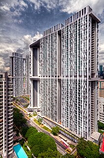
The Pinnacle@Duxton is a 50-storey residential development in Singapore 's city center, next to the business district. All seven connected towers are collectively the world's tallest public residential buildings, and featuring the two longest sky gardens ever built on skyscrapers, at 500m each.

Commonwealth is a subzone of Queenstown, located in the central-western part of Singapore. It is named after the Commonwealth of Nations. Commonwealth consists of Housing and Development Board flats, and there is one primary school and a secondary school in the area, New Town Primary School and Queensway Secondary School. SBS Transit Bus Services 32, 51, 93, 100, 105, 111, 122, 123, 145, 147, 153, 186, 195, 196, 198 and SMRT Buses Services 61, 855, 961 & 970 passes through this area. The nearest Mass Rapid Transit station is Commonwealth MRT station. Amenities in the area include Blessed Sacrament Church, Faith Methodist Church, Masjid Mujahidin Mosque, Queenstown Community Centre, Queenstown Lutheran Church, Ridout Tea Garden, Shuang Long Shan Wu Shu Ancestral Hall, Sri Muneeswaran Temple and Tanglin Halt Food Centre and Market.

HortPark is a 9-hectare (22-acre) park and garden located in the southwestern part of Singapore. It opened in December 2007, but it was not until 10 May 2008 that it was officially launched by Prime Minister Lee Hsien Loong.

Melvin Yong Yik Chye is a Singaporean politician. A member of the governing People's Action Party (PAP), he is a Member of the 14th Parliament and has been representing Radin Mas Single Member Constituency (SMC) since 2020. He previously represented the Moulmein–Cairnhill ward of Tanjong Pagar Group Representation Constituency (GRC) from 2015 to 2020.

Guoco Tower is a mixed-use development skyscraper in Tanjong Pagar of the Downtown Core district of Singapore. With a height of 283.7 m (931 ft), it is currently the tallest building in Singapore, breaking the record held jointly by UOB Plaza, One Raffles Place and Republic Plaza for more than 20 years.

library@harbourfront, formerly known as Bukit Merah Public Library, is a public library located at VivoCity, Singapore. It is the largest shopping mall public library in Singapore.

Katong Park is neighborhood park located in Katong, Singapore at the junction of Meyer Road and Fort Road. Built in the 1930s above the buried remains of Fort Tanjong Katong, it was one of Singapore’s oldest parks with the first public bathing pagar and was highly popular with families during the weekends. After the coastal reclamation works in the 1970s, the park lost its sea frontage and declined greatly in popularity. It now remains as a small community park serving nearby residents.


