
Exchangeable image file format is a standard that specifies formats for images, sound, and ancillary tags used by digital cameras, scanners and other systems handling image and sound files recorded by digital cameras. The specification uses the following existing encoding formats with the addition of specific metadata tags: JPEG lossy coding for compressed image files, TIFF Rev. 6.0 for uncompressed image files, and RIFF WAV for audio files. It does not support JPEG 2000 or GIF encoded images.

The Ricoh Company, Ltd. is a Japanese multinational imaging and electronics company. It was founded by the now-defunct commercial division of the Institute of Physical and Chemical Research (Riken) known as the Riken Concern, on 6 February 1936 as Riken Sensitized Paper. Ricoh's headquarters are located in Ōta, Tokyo.
Picture Transfer Protocol (PTP) is a protocol originally developed by the Photographic and Imaging Manufacturers Association (PIMA) to allow the transfer of images from digital cameras to computers and other peripheral devices without the need for additional device drivers. The protocol was standardized by the ISO in 2005. The current version of the standard is ISO 15740:2013.

A geotagged photograph is a photograph which is associated with a geographic position by geotagging. Usually this is done by assigning at least a latitude and longitude to the image, and optionally elevation, compass bearing and other fields may also be included.
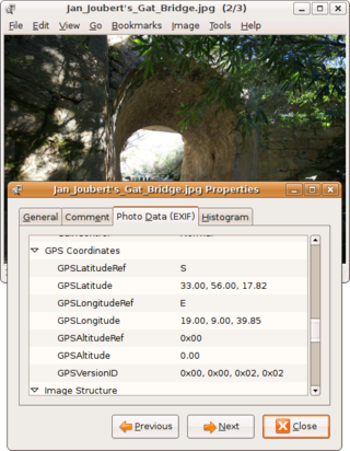
Geotagging, or GeoTagging, is the process of adding geographical identification metadata to various media such as a geotagged photograph or video, websites, SMS messages, QR Codes or RSS feeds and is a form of geospatial metadata. This data usually consists of latitude and longitude coordinates, though they can also include altitude, bearing, distance, accuracy data, and place names, and perhaps a time stamp.
Address geocoding, or simply geocoding, is the process of taking a text-based description of a location, such as an address or the name of a place, and returning geographic coordinates, frequently latitude/longitude pair, to identify a location on the Earth's surface. Reverse geocoding, on the other hand, converts geographic coordinates to a description of a location, usually the name of a place or an addressable location. Geocoding relies on a computer representation of address points, the street / road network, together with postal and administrative boundaries.
The Location API for Java ME is a compact and generic Java 2 ME API that produces information about the device's present physical location to Java applications. This API can be optionally supported by mobile phone and PDA manufacturers, with the minimum Java platform required for this API being CLDC v1.1.
Global Navigation Satellite System (GNSS) receivers, using the GPS, GLONASS, Galileo or BeiDou system, are used in many applications. The first systems were developed in the 20th century, mainly to help military personnel find their way, but location awareness soon found many civilian applications.

FastPictureViewer is a freemium image viewer for Windows XP and later. Its aim is to facilitate quick review, rating and annotation of large quantities of digital images in the early steps of the digital workflow, with an emphasis on simplicity and speed. As an app with a freemium license, a basic version is available cost-free for personal, non-profit or educational uses, while a commercial license is required for the professional version with additional features. The basic version starts as a full version trial.
Real-time geotagging refers to the automatic technique of acquiring media, associating a specific location with the media, transferring the media to an online map and publishing the media in real time. It is thus an extension of an automatic geotagging process, requiring an in-built or attached location acquisition device, but also requires communication with a wireless data transfer device. Most modern smartphones and several digital cameras already integrate camera, aGPS, and wireless data transfer into one device, thus directly producing a geotagged photograph. Real-time geotagging is sometimes referred to as "mobile geotagging" or "autogeotagging", but this does not imply the real-time publishing step.

A satellite navigation device, satnav device or satellite navigation receiver is a user equipment that uses one or more of several global navigation satellite systems (GNSS) to calculate the device's geographical position and provide navigational advice. Depending on the software used, the satnav device may display the position on a map, as geographic coordinates, or may offer routing directions.

The Coolpix P6000 is a digital camera introduced by the Nikon Corporation in August 2008.

The Nokia E75 is a mobile phone from the Eseries range with a side sliding QWERTY keyboard and also front keypad.

Samsung GT-i8910 Omnia HD is a smartphone manufactured by Samsung Electronics, first announced at MWC 2009 on February 18, 2009. The device was the first phone capable of playing and recording 720p HD video. It runs on the S60 5th Edition (Symbian^1) platform, the only Samsung device to do so.

The Motorola Cliq is an Android-based smartphone by Motorola.

The Nikon D3100 is a 14.2-megapixel DX format DSLR Nikon F-mount camera announced by Nikon on August 19, 2010. It replaced the D3000 as Nikon's entry level DSLR. It introduced Nikon's new EXPEED 2 image processor and was the first Nikon DSLR featuring full high-definition video recording with full-time autofocus and H.264 compression, instead of Motion JPEG compression. It was also the first Nikon DSLR to provide high-definition video recording at more than one frame rate.

Red Hen Systems, Inc. is a technology company that develops integrated hardware and software for multimedia asset mapping. Their spatial digital video recorders (DVRs) and still cameras instantly geotag video and still photos at the time of data collection. Corresponding mapping software provides the capability to view photographs, video, and audio using GPS coordinates.

The Nikon D5100 is a 16.2-megapixel DX-format DSLR F-mount camera announced by Nikon on April 5, 2011. It features the same 16.2-megapixel CMOS sensor as the D7000 with 14-bit depth, while delivering Full HD 1080p video mode at either 24, 25 or 30 fps. The D5100 is the first Nikon DSLR to offer 1080p video at a choice of frame rates; previous Nikon DSLRs that recorded 1080p only did so at 24 fps. It replaced the D5000 and was replaced by the D5200.
The Ricoh G700 and Ricoh G700SE are tough digital compact cameras made by Ricoh. They are marked out by meeting high industrial standards for protection against ingress of dust, water, and for its toughness against drops. They can be cleaned with ethanol and hypochlorous acid-based disinfectants, making them suitable for medical environments requiring high standards of hygiene. Their large buttons are designed for use with gloved hands.


