Ang Mo Kio is a planning area and residential town situated in the North-East of Singapore. Located approximately 11 kilometres (6.8 mi) north of the Downtown Core district, Ang Mo Kio is the 3rd most populated planning area in the North-East Region and ranks 8th in terms of population in the country overall. The planning area is located at the south-western corner of the North-East Region, bordered by the planning areas of Yishun to the north, Sengkang to the north-east, Serangoon to the east, Bishan to the south and the Central Water Catchment to the west.
Woodlands is a planning area and residential town located in the North of Singapore. As of 2019, the town has a population of 254,733. It is the densest planning area and is the regional centre for the North Region of the country.
Clementi is a planning area and residential town located at the easternmost fringe of the West Region of Singapore. The town borders Bukit Batok to the north, Bukit Timah to the northeast, Queenstown to the east and Jurong East to the west.

Kallang is a planning area and residential town located in the Central Region of Singapore.

Bukit Timah, often abbreviated as Bt Timah, is a planning area and residential estate located in the westernmost part of the Central Region of Singapore. Bukit Timah lies roughly 10 kilometres (6.2 mi) from the Central Business District, bordering the Central Water Catchment to the north, Bukit Panjang to the northwest, Queenstown to the south, Tanglin to the southeast, Clementi to the southwest, Novena to the east and Bukit Batok to the west.

Bishan, also known as either Bishan New Town or Bishan Town, is a planning area and matured residential town located at the northernmost portion of the Central Region of Singapore. Statistically, the area is ranked the 38th biggest in terms of geographical size and the 22nd most populated planning area in the country. It is located at the most Central point of Singapore, and is made out of Upper Thomson, Marymount, Shunfu, Sin Ming, Bishan North and Bishan East. There are also many private residential properties in Bishan. This makes Bishan ranked 15th in terms of population density. Apart from its boundary with the Central Water Catchment in the west, Bishan borders three other planning areas: Ang Mo Kio to the north, Toa Payoh to the south, and Serangoon to the east.
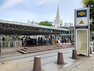
City Hall MRT station is an underground Mass Rapid Transit (MRT) interchange station on the North South Line (NSL) and East West Line (EWL). Situated in the Downtown Core district of Singapore, it is underneath Stamford Road near the road junctions with North Bridge Road and St Andrew's Road. The station is near landmarks such as the City Hall, Raffles City, the Padang, St Andrew's Cathedral and The Cenotaph.

Raffles Place MRT station is an underground Mass Rapid Transit (MRT) interchange station on the North South Line (NSL) and East West Line (EWL) in Singapore. Located in the Downtown Core, the station is underneath Raffles Place, the centre of Singapore's financial district, south of the Singapore River. The station serves various landmarks including Merlion Park and the Asian Civilisations Museum and various commercial buildings such as One Raffles Place and OCBC Centre.

Buona Vista MRT station is a Mass Rapid Transit (MRT) interchange station on the East West line and Circle line in Queenstown, Singapore. This station is close to one-north, a high technology business park for the biomedical science, infocomm technology and media industries. It is located near the junction of North Buona Vista Road, Commonwealth Avenue and Commonwealth Avenue West.

Bedok is a planning area and matured residential town located in the geographical region of Tanah Merah along the south-eastern coast of the East Region of Singapore. Population wise, Bedok is the largest planning area in the Republic, being home to approximately 280,000 residents. This high demographic is largely explained by the affordable public housing in Bedok New Town, due to its relatively distant location from the Central Area. Besides public housing developments, private residences are also prevalent in the area, most of which are found in the neighbourhoods of Bayshore, Frankel Avenue and Siglap, in western and southwestern Bedok. Apart from the maritime boundary that the area shares with the Singapore Strait to the south and southeast, Bedok is also bounded by five other planning areas: Paya Lebar to the north, Hougang to the northwest, Tampines to the northeast and east, Geylang to the west and Marine Parade to the southwest.

Raffles Place is the centre of the Financial District of Singapore and is located south of the mouth of the Singapore River. It was first planned and developed in the 1820s as Commercial Square to serve as the hub of the commercial zone of Singapore in Raffles Town Plan. It was renamed Raffles Place in 1858 and is now the site of a number of major banks. It is located in the Downtown Core within the Central Area, and features some of the tallest buildings and landmarks of the country.

Marina Bay is a bay located in the Central Area of Singapore, surrounded by the perimeter of four other planning areas, the Downtown Core, Marina East, Marina South and Straits View. The area surrounding the bay itself, also called Marina Bay, is a 360 hectare extension to the adjacent Central Business District. It is also the new downtown of Singapore, built on reclaimed land.
The following lists events that happened during 1997 in Singapore.

Tanjong Pagar MRT station is an underground Mass Rapid Transit (MRT) station on the East West line located at Maxwell Road between the junctions of Peck Seah Street and Cecil Street in Downtown Core, Singapore. The station was built in the 1980s, and was opened in December 1987. Taking its name from Tanjong Pagar Road, which is located near the station, it is located near Tanjong Pagar Complex, the AXA Tower and International Plaza.
This is a list of Singapore-related articles by alphabetical order. To learn quickly what Singapore is, see Outline of Singapore. Those interested in the subject can monitor changes to the pages by clicking on Related changes in the sidebar. A list of to do topics can be found here.

The Museum Planning Area is a planning area located in the Central Area of the Central Region of Singapore. The area plays a "bridging role" between the Orchard area and the Downtown Core, which necessitates proper transport networks for vehicles, pedestrians and public transport. Due to the sheer size of green areas in the district, the Urban Redevelopment Authority (URA) has designated it a 'green lung' in the Central Area. However, the Museum Planning Area is also home to cultural and commercial activities. Around 65% of the area is available for future development, making it a hotbed for new infrastructure and buildings.
Raffles Place Park is a 0.6-hectare park in Singapore. It is strategically located in the central business district, having intensive pedestrian traffic with commercial buildings located on both sides. Many working subjects and professionals around the area visit the park.

Bukit Batok Town Park is a nature park located in the precinct of Guilin in the town of Bukit Batok, Singapore. The park was created from a disused granite quarry. As such, it has a resemblance to the granite rock formations in Guilin, China. Hence it is also known as Little Guilin or Xiao Guilin among the Chinese.

Kallang Riverside Park is a riverine park in Kallang, Singapore. It sits on the confluence of the Kallang River and Rochor River, north of the Kallang Basin.
Yuhua is a subzone region located in the town of Jurong East, Singapore. Yuhua comprises two subzones, Yuhua East and Yuhua West. The area's HDB flats are under the management of Jurong-Clementi Town Council and the people of this precinct are represented in parliament by either Grace Fu or Rahayu Mahzam, depending on where they stay.