
Punggol, alternatively spelled as Ponggol, is a planning area and new town situated on the Tanjong Punggol peninsula in the North-East Region of Singapore. The town directly borders Sengkang to the south and shares riverine boundaries with the planning area of Seletar to the west and Pasir Ris to the east. Bounding the town to the north and north-east is the Straits of Johor, with Coney Island included as a part of the Punggol planning area.

Pasir Ris is a planning area and residential town located in the East Region of Singapore. It is bordered by Tampines and Paya Lebar to the south, Sengkang to the southwest and Changi to the east. The planning area also shares riverine boundary with Punggol to the west, separated by the Serangoon River, as well as having a maritime boundary with the North-Eastern Islands planning area, across the Straits of Johor.

Tampines is the regional centre and second-most populous planning area of the East Region of Singapore. With a population of 259,900 living across its five subzones, it is the third-most populous planning area in Singapore, according to the Singapore Cencus of Population 2020. It is home to approximately 5% of Singapore's population. Tampines is bordered to the west by Bedok and Paya Lebar, to the north by Pasir Ris, to the east by Changi, and to the south by the Straits of Singapore. Situated in the historical region of Tanah Merah, its present-day terrain is particularly flat due to the large-scale sand quarrying in the 1960s.

Yishun, formerly known as Nee Soon, is a residential town located in the northeastern corner of the North Region of Singapore, bordering Simpang and Sembawang to the north, Mandai to the west, the Central Water Catchment to its southwest, Ang Mo Kio to its south, as well as Seletar and Sengkang to its east.

Pasir Ris MRT station is an elevated Mass Rapid Transit (MRT) station on the East West line (EWL) in Pasir Ris, Singapore. Situated along Pasir Ris Central adjacent to Pasir Ris Bus Interchange and the White Sands Shopping Mall, it is the eastern terminus of the EWL and, as of June 2021, the only MRT station within Pasir Ris. The station exterior has the characteristic dome-shaped segmented roof also seen on other elevated EWL stations.

Queenstown is a planning area and satellite residential town situated on the south-westernmost fringe of the Central Region of Singapore. It borders Bukit Timah to the north, Tanglin to the northeast, Bukit Merah to the east and southeast, as well as Clementi to the northwest and west. Its southern and southwesternmost limits are bounded by the Pandan Strait.
Toa Payoh is a planning area and matured residential town located in the northern part of the Central Region of Singapore. Toa Payoh planning area borders Bishan and Serangoon to the north, the Central Water Catchment to the northwest, Kallang to the south, Geylang to the southeast, Novena to the west and Hougang to the east. Toa Payoh New Town is situated in the western portion of the Toa Payoh planning area. The latter occupies a much larger area, encompassing estates such as Potong Pasir and Bidadari.
Tiong Bahru is a housing estate located within the Bukit Merah Planning Area, in the Central Region of Singapore. Tiong Bahru was constructed in the 1920s by the Singapore Improvement Trust, the predecessor to the Housing Development Board and an entity of the British colonial authority providing mass public housing in Singapore and is the oldest housing estate in Singapore. The main estate consists of 30 apartment blocks with over 900 units of two to five rooms. There are also high-rise Housing and Development Board (HDB) flats and condominiums along Boon Tiong Road, Jalan Membina and Kim Tian Road which surround the main estate.

Bedok is a planning area and matured residential town located in the geographical region of Tanah Merah along the south-eastern coast of the East Region of Singapore. Population wise, Bedok is the largest planning area in the Republic, being home to approximately 280,000 residents. This high demographic is largely explained by the affordable public housing in Bedok New Town, due to its relatively distant location from the Central Area. Besides public housing developments, private residences are also prevalent in the area, most of which are found in the neighbourhoods of Bayshore, Frankel Avenue and Siglap, in western and southwestern Bedok. Apart from the maritime boundary that the area shares with the Singapore Strait to the south and southeast, Bedok is also bounded by five other planning areas: Paya Lebar to the north, Hougang to the northwest, Tampines to the northeast and east, Geylang to the west and Marine Parade to the southwest.

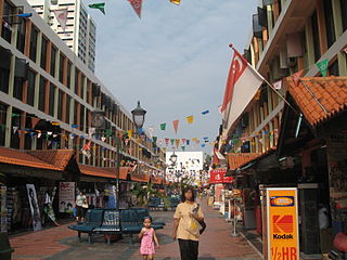
Changi Village is a modern village situated at the northern tip of Changi which is at the eastern end of Singapore. It is the usual connecting point for travellers heading to Pulau Ubin or Malaysia by ferry. Fishermen in the kelongs located in the Serangoon Harbour offshore also use this jetty as a drop off point to come onto mainland. Changi Village also has many resorts and leisure facilities to cater for a weekend getaway for many Singaporeans. The area is classified by Urban Redevelopment Authorities as under the planning area of Changi and in the subzone of Changi Point. It is also classified under District 17 for property indexing.

Singaporean cuisine derived from several ethnic groups which have developed through centuries of political, economic, and social changes of this cosmopolitan city-state.

Sengkang is a planning area and residential town located in the North-East Region of Singapore. The town is the second most populous in the region, being home to 249,370 residents in 2020. Sengkang shares boundaries with Seletar and Punggol in the north, Pasir Ris and Paya Lebar in the east, Hougang and Serangoon to the south, as well as Yishun and Ang Mo Kio to the west.

Pasir Ris Park is a beach park located in the eastern part of Singapore. It covers an area of 70 hectares, and was partially built on reclaimed land. Initially planned in the late 1970s to serve people living in the vicinity, the park was designed with the help of two Japanese landscape specialists. Construction began on the park in September 1984, and the park was opened in phases from August 1986 to 1991. The park was further expanded in 2007, with the addition of new areas such as a herb garden.
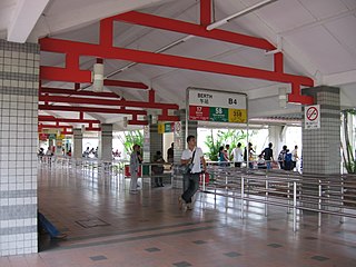
Pasir Ris Bus Interchange is a bus interchange located at Pasir Ris in the eastern part of Singapore. It is located off Pasir Ris Drive 3, adjacent to Pasir Ris MRT station and near White Sands Shopping Centre. This bus interchange also serves as a pick-up/drop-off point for shuttle buses ferrying NSF men heading to the SAF Ferry Terminal for their shuttle ferry to Pulau Tekong.

Changi Beach Park is a beach park located at the northern tip of Changi in the eastern region of Singapore.

This article shows the notable future developments in Singapore. Majority of them are currently under construction with most to be completed within the next five years.
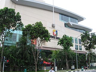
White Sands Shopping Mall, also known as White Sands, is a 5-storey shopping mall in Pasir Ris, Singapore. It is located near Pasir Ris MRT station and Pasir Ris Bus Interchange and features a basement with retail outlets and two additional floors of basement carparks.

Sengkang Sports Centre, formerly known as Sengkang Sports and Recreation Centre, is a sports complex in Anchorvale of Sengkang New Town, Singapore, near Farmway LRT station. It was scheduled to open in end 2007, but its inauguration was delayed until mid-late 2008.
Pasir Ris Public Library is a public library in Pasir Ris, Singapore, located inside White Sands. It is near Pasir Ris MRT station and Pasir Ris Bus Interchange. It is the first shopping mall library to feature a special teens’ mezzanine, a dedicated space for teens to hang out, both for reading and leisure.
