Mount St. Helens National Volcanic Monument is a U.S. National Monument that includes the area around Mount St. Helens in Cowlitz and Skamania Counties, Washington. It was established on August 27, 1982, by U.S. President Ronald Reagan, following the 1980 eruption. The 110,000 acre (445 km2) National Volcanic Monument was set aside for research, recreation, and education. Inside the monument, the environment is left to respond naturally to the disturbance. It was the third national monument to be managed by the U.S. Forest Service.

Raffles Place MRT station is an underground Mass Rapid Transit (MRT) interchange station on the North South Line (NSL) and East West Line (EWL) in Singapore. Located in the Downtown Core, the station is underneath Raffles Place south of the Singapore River. The station serves various landmarks including The Fullerton Hotel, Merlion Park and the Asian Civilisations Museum and various commercial buildings such as One Raffles Place and OCBC Centre.
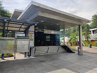
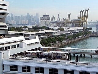
HarbourFront MRT station is an underground Mass Rapid Transit (MRT) interchange station in Singapore. The termini of the North East line (NEL) and Circle line (CCL), the station serves the HarbourFront area and Sentosa. Surrounding retail and commercial developments include VivoCity and HarbourFront Centre, and the station is near HarbourFront Bus Interchange and the Singapore Cruise Centre.
Bukit Merah, also known as Redhill, is a planning area and new town situated in the southernmost part of the Central Region of Singapore. The planning area borders Tanglin to the north, Queenstown to the west and the Downtown Core, Outram and Singapore River planning areas of the Central Area to the east. It also shares a maritime boundary with the Southern Islands planning area to the south. Bukit Merah is linked to Sentosa Island via Sentosa Gateway, Sentosa Broadwalk, Sentosa Express and the Cable Car.
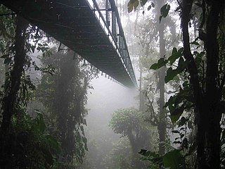
Canopy walkways – also called canopy walks, treetop walks or treetop walkways – provide pedestrian access to a forest canopy. Early walkways consisted of bridges between trees in the canopy of a forest; mostly linked up with platforms inside or around the trees. They were originally intended as access to the upper regions of ancient forests for scientists conducting canopy research. Eventually, because they provided only limited, one-dimensional access to the trees, they were abandoned for canopy cranes. Today they serve as ecotourism attractions in places such as Dhlinza Forest, KwaZulu-Natal, South Africa, Taman Negara National Park, Malaysia, Sedim River, Kulim, Nyungwe National Park, Rwanda and Kakum National Park, Ghana.
Telok Blangah is a subzone region and housing estate located in the area behind Keppel Harbour in Bukit Merah, Singapore. Teluk Blanga is the district between Pasir Panjang and Tanjong Pagar.
The following lists events that happened during 1971 in Singapore.

Mount Faber, formerly Telok Blangah Hill, is a hill about 94 metres (308 ft) in height, located in the town of Bukit Merah in the Central Region of Singapore. It overlooks the Telok Blangah area and the western parts of the Central Area. The summit is accessible by Mount Faber Road or Mount Faber Loop via Morse Road, but there are many footpaths or trails leading up the hill. The main paths are: Marang Trail, which leads from Marang Road at the Harbourfront MRT station, and the Southern Ridges Park Connector which connects from Telok Blangah Hill Park, Kent Ridge Park, and Henderson Waves.

West Coast Highway is a major arterial road in Singapore which links Jurong industrial estate and Clementi New Town to the city. It is an at-grade road from its junction with Pandan Loop and West Coast Road to its interchange with Pasir Panjang Road, where it becomes a grade-separated viaduct; the viaduct merges with Keppel Road before its interchange with Ayer Rajah Expressway. The total length of the highway is 11 km. The viaduct is newer than the at-grade section, having been completed in 2006.

Masjid Haji Muhammad Salleh & Maqam Habib Noh is a mosque and Muslim mausoleum respectively located at 37 Palmer Road, top of Mount Palmer, in Singapore. The mausoleum and its adjacent mosque are under the purview of Majlis Ugama Islam Singapura.

This article shows the notable future developments in Singapore. Most of them are currently under construction with most to be completed within the next five years.

Kent Ridge Park is a 47-hectare public park located in Kent Ridge, Singapore, between the National University of Singapore and the Singapore Science Park. Due to its undisturbed habitat and abundant plant life, it is a popular venue for bird-watchers and eco-tourists.

The Southern Ridges comprise 10 kilometres (6.2 mi) of trails connecting three parks along the southern ridge of Singapore. Some of the attractions along these trails include its greenery and the connecting bridges. This project linked up the parks between the Kent Ridge Park and HarbourFront. The idea to link these parks was coined in 2002 by Urban Redevelopment Authority (URA) and it took 2 years to complete and cost S$25.5 million.

Craigieburn Forest Park is a protected area in the South Island of New Zealand, adjacent to Arthur's Pass National Park to the north.
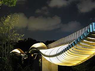
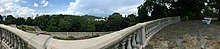
Henderson Waves is a pedestrian bridge crossing Henderson Road in the Southern Ridges in Singapore. The bridge is one of two pedestrian bridges that form part of the walking trail connecting the Southern Ridges with Mount Faber along with Alexandra Arch, and is the highest pedestrian bridge in Singapore. The sun-shading, curved, wooden ribs are illuminated at night.

HortPark is a 9-hectare (22-acre) park located in Queenstown, Singapore. It opened in December 2007 and was officially launched by Prime Minister Lee Hsien Loong in May 2008.
Bukit Purmei is a small housing estate within Bukit Merah planning area in Singapore, near Telok Blangah estate. Bukit Purmei consists of 15 HDB blocks, private apartments and landed property.

Alkaff Mansion is an early 20th-century colonial bungalow located within the Telok Blangah Hill Park in Singapore. The hill was originally called Mt Washington, and was part of a sprawling land estate owned by a wealthy Arab Syed Shaikh bin Abdul Rahman Alkaff. Around 1918, Syed Shaikh Alkaff built the bungalow as his primary residence which he abandoned after World War II. The property was later acquired by the government.

library@harbourfront, formerly known as Bukit Merah Public Library, is a public library located at VivoCity, Singapore. It is the largest shopping mall public library in Singapore.
The Keppel Hill Reservoir is an abandoned reservoir near Mount Faber in the southern part of Singapore. It was built during the colonial period of Singapore. It fell into disuse due to its small capacity and was eventually forgotten.