West Coast Park

Last updated
West Coast Park
Aerial panorama of West Coast Park, shot 2016.jpg
Aerial panorama of West Coast Park
West Coast Park
TypeRegional
LocationSouthwestern coast of Singapore
Coordinates 1°17′28″N103°46′01″E / 1.291°N 103.767°E / 1.291; 103.767
Established1970s
Managed by National Parks Board
StatusOpen to the public
Connecting transportBus stop ID: 17291, 16241

West Coast Park is a large regional park located at the south-western corner of West Coast, Singapore. [1] It runs parallel to West Coast Highway, [2] and covers an area of roughly 50 hectares of park land consisting of three areas, each with its own variety of activities promising to ensure a fun-filled day for visitors both young and old. [1] Since its inception, the park has been themed as the "Play Centre in the West". [3]

Contents

Description

Covering an area of 50 ha (120 acres), [4] West Coast Park is bounded by West Coast Highway to the north, and by Harbour Drive and the Straits of Singapore to the south, and is divided into two parts by West Coast Ferry Road. [5]

History

First planned in the mid 1970s, the development of West Coast Park began in 1977. [6] Constructed with the assistance of two Japanese experts [7] and sited on reclaimed land in Pasir Panjang, the 21 ha (52 acres) park was envisioned as a smaller version of East Coast Park, and was to be developed in two phases. The first phase of development comprised a freshwater lake, open spaces, a playground, and an area for picnics and barbeques, while the second phase entailed the further development of the open spaces. [8] In addition, a 40 ha (99 acres) park extension between West Coast Road and Pasir Panjang Road was developed by the early 1980s. [9]

In the early 1980s, the Singapore Armed Forces Display and Singapore International Kite Festival were held at the park annually, but it was not seen as a desirable destination by the general public, which The Straits Times attributed to the park having little to offer. Subsequently, the Parks and Recreation Department announced plans to upgrade the park for over S$1 million in September 1984, proposing to add jogging and cycling facilities, along with benches and shelters with unique designs. [10] The upgrading works, which also added a pond, flower beds and an open space for kite flying, were completed by 1986, and cost about S$5 million. In addition, a boat storage facility was proposed to house boats parked along the shore in the park, [11] but plans were shelved in November 1985 due to reduced demand, with boat owners allowed to park their boats along a 1 km (0.62 mi) long section of the park instead. [12] Subsequently, in response to complaints from the public regarding the presence of boaters' huts in the park, boat owners were ordered to move to Tuas by the Port Of Singapore Authority in June 1989. [13] In July 1987, the Republic of Singapore Yacht Club announced plans to build a marina in the park, [14] and plans to build a marsh garden at the park's western end were announced in September 1988. Comprising a 1.5 ha (3.7 acres) pond ringed by mud flats and wetland vegetation, and expected to cost S$300,000, the garden was intended to serve as a feeding and breeding spot for native and migratory birds. [15]

Several facilities in the park were relocated to facilitate the construction of Pasir Panjang Terminal in the 1990s, [16] while a section of the park was cleared to make way for an access road to the terminal. [17] In addition, in 1995, the Parks and Recreation Department announced plans to redevelop the park after the completion of land reclamation works for Pasir Panjang Terminal. Intended to give the park a maritime theme, the redevelopment scheme entailed the addition of an observation tower designed after a lighthouse and a maritime walk. [18] The park was closed for redevelopment in 1998, and reopened two years later upon the completion of the first phase of redevelopment. Costing S$8.3 million, this phase comprised the addition of a sand play area, barbeque pits, a marsh garden, and a 1.1 ha (2.7 acres) playground, Singapore's largest at the time. [19] The Straits Times noted that the park's popularity increased after the revamp, [20] while the second phase of redevelopment started in 2001. [19]

Community efforts

The Marsh Garden within the park has undergone a rejuvenation project, which was launched in conjunction with Earth Day 2008 on 22 April 2008. The 1-hectare garden was home to 15 species of birds and 10 species of plants. A collaboration with the public, private and people sectors, partners in this project include Shell Oil Company, National Parks Board (NParks), nature enthusiasts and residents in the South West district. [21] A total of 200 new saplings was planted in phases to rejuvenate the biodiversity of the mangrove habitat. [22]

Facilities

The park includes barbeque pits, a campsite, and a marsh garden, along with a McDonald's restaurant, a dog run, and a bicycle obstacle course. [23]

Grand Lawn

The 3.5-hectare (8.65 acres) Grand Lawn can support spaces for picnics, frisbee-playing and carnivals. It is also a common spot for kite-flying. As noted by the National Parks, the Grand Lawn is one of the biggest lawns in Singapore, with an excellent sea view. [1]

Adventure Play Area

The facilities at the park include the Adventure Play Area, a playground occupying about 1.1 hectares of land and comprising eight play sets equipped to cater to children of multiple age groups.

See also

Related Research Articles

<span class="mw-page-title-main">North East MRT line</span> Mass Rapid Transit line in Singapore

The North East Line (NEL) is a high-capacity Mass Rapid Transit (MRT) line in Singapore. Operated by SBS Transit, the 20-kilometre (12 mi) line is the MRT's shortest. It runs from HarbourFront station in southern Singapore to Punggol station in the northeast, serving 16 stations via Chinatown, Little India, Serangoon and Hougang. Coloured purple on official maps, it is Singapore's third MRT line and the world's first fully-automated underground driverless heavy rail line.

<span class="mw-page-title-main">Ang Mo Kio</span> Planning Area and HDB Town in Singapore

Ang Mo Kio is a planning area and residential town situated in the North-East region of Singapore. Located approximately 11 km (6.8 mi) north of the Downtown Core district, Ang Mo Kio is the 3rd most populated planning area in the North-East region and ranks 8th in terms of population in the country overall. The planning area is located at the south-western corner of the North-East region, bordered by the planning areas of Yishun to the north, Sengkang to the north-east, Serangoon to the east, Bishan to the south and the Central Water Catchment to the west.

<span class="mw-page-title-main">Outram Park MRT station</span> Mass Rapid Transit station in Singapore

Outram Park MRT station is an underground Mass Rapid Transit (MRT) interchange station in Singapore. The station is on the East–West, North East and Thomson–East Coast lines, and is located near the junction of Outram Road, Eu Tong Sen Street and New Bridge Road on the boundary of Bukit Merah and Outram planning areas. It is the closest MRT station to Singapore General Hospital, the Police Cantonment Complex, Outram Community Hospital and the Health Promotion Board. The station was included in the early plans of the MRT network in 1982; it was constructed a part of the Phase I MRT segment from Novena, and was due to be completed by December 1987.

<span class="mw-page-title-main">Pan Island Expressway</span> Road in Singapore

The Pan Island Expressway is the oldest and longest expressway in Singapore. It is also Singapore's longest road. The expressway runs from the East Coast Parkway near Changi Airport in the east to Tuas in the west and has a total length of 42.8 kilometres (26.6 mi).

<span class="mw-page-title-main">Pasir Panjang</span> Subzone of Queenstown Planning Area

Pasir Panjang is an area located at the southern part of Queenstown in Singapore. Kent Ridge Park is a topographical feature which runs adjacent to Pasir Panjang.

<span class="mw-page-title-main">East Coast Park</span> Beach park in the eastern part of Singapore

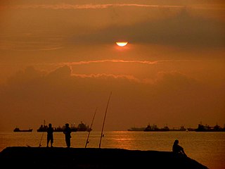
East Coast Park is a beach and a park on the southeastern coast of Singapore. It stretches along the south of Marine Parade, Bedok and Tampines. It was opened in the 1970s, after the Singapore government had completed reclaiming land off the coast at Katong, from Kallang to Changi. While serves the needs of communities in the east, other Singapore residents do visit the park for sports, recreation, and food.

<span class="mw-page-title-main">Haw Par Villa MRT station</span> Mass Rapid Transit station in Singapore

Haw Par Villa MRT station is an underground Mass Rapid Transit (MRT) station on the Circle line (CCL) in Queenstown, Singapore. Located underneath West Coast Highway and Pasir Panjang Road, the station serves the nearby Haw Par Villa, alongside the Pasir Panjang Wholesale Centre.

<span class="mw-page-title-main">Pasir Ris Park</span> Park in Singapore

Pasir Ris Park is a beach park located in the eastern part of Singapore. It covers an area of 70 hectares, and was partially built on reclaimed land. Initially planned in the late 1970s to serve people living in the vicinity, the park was designed with the help of two Japanese landscape specialists. Construction began on the park in September 1984, and the park was opened in phases from August 1986 to 1991. The park was further expanded in 2007, with the addition of new areas such as a herb garden.

<span class="mw-page-title-main">Pasir Ris Bus Interchange</span> Bus interchange in Pasir Ris, Singapore

Pasir Ris Bus Interchange is a bus interchange located at Pasir Ris in the eastern part of Singapore. It is located off Pasir Ris Drive 3, adjacent to Pasir Ris MRT station and near White Sands Shopping Centre. This bus interchange also serves as a pick-up/drop-off point for shuttle buses ferrying NSF men heading to the SAF Ferry Terminal for their shuttle ferry to Pulau Tekong.

<span class="mw-page-title-main">Eunos Bus Interchange</span>

Eunos Bus Interchange is a bus interchange located in Geylang East, Singapore. It is located and built beside Eunos MRT station and is surrounded by Eunos Road 2, Eunos Crescent and Sims Avenue.

<span class="mw-page-title-main">Changi Beach Park</span>

Changi Beach Park is a beach park located at the northern tip of Changi in the eastern region of Singapore.

<span class="mw-page-title-main">Future developments in Singapore</span>

This article shows the notable future developments in Singapore. Most of them are currently under construction with most to be completed within the next five years.

<span class="mw-page-title-main">Labrador Nature Reserve</span>

Labrador Nature Reserve, also known locally as Labrador Park, is located in the southern part of mainland Singapore. It is home to the only rocky sea-cliff on the mainland that is accessible to the public. Since 2002, 10 hectares of coastal secondary-type vegetation and its rocky shore have been gazetted as a nature reserve and its flora and fauna preserved by NParks.

Yishun Park is a 14-hectare park located in Yishun, Singapore. It is within the vicinity of Northland Primary School, SAFRA Yishun Country Club and Yishun Park Hawker Centre. The park is connected to Yishun Pond Park by an 84-meter elevated bridge.

<span class="mw-page-title-main">Kent Ridge Park</span> Park in Singapore

Kent Ridge Park is a 47-hectare public park located in Kent Ridge, Singapore, between the National University of Singapore and the Singapore Science Park. Due to its undisturbed habitat and abundant plant life, it is a popular venue for bird-watchers and eco-tourists.

<span class="mw-page-title-main">Reflections at Bukit Chandu</span>

Reflections at Bukit Chandu is a World War II interpretive centre developed and managed by the National Archives of Singapore, located on Bukit Chandu off Pasir Panjang Road in Singapore.

<span class="mw-page-title-main">Cross Island MRT line</span> Future Mass Rapid Transit line in Singapore

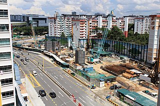
The Cross Island Line (CRL) is a high capacity Mass Rapid Transit (MRT) line under development in Singapore. It will run in an east–west direction from Changi to Jurong Industrial Estate via Loyang, Pasir Ris, Hougang, Serangoon North, Ang Mo Kio, Sin Ming, Bukit Timah, Clementi and West Coast. From Pasir Ris, the line will branch off to Punggol. The 58-kilometre (36 mi) line will replace the East West Line as the longest line on the MRT network upon its complete opening by the 2040s, serving about 27 stations.

Wan Soon Bee is a Singaporean former politician. A member of the governing People's Action Party (PAP), he was the Member of Parliament (MP) for West Coast Constituency, Pasir Panjang Group Representation Constituency (GRC), Brickworks GRC and West Coast GRC.

References

  1. 1 2 3 "Sights and Activities in West Coast Park". National Parks Board - Singapore. Retrieved 30 December 2023.
  2. "West Coast Park". National Parks Board. Retrieved 2023-12-30.
  3. "West Coast Park". www.sciencepark.com.sg. Retrieved 2023-12-30.
  4. "West Coast Park". nparks.gov.sg. National Parks Board. Retrieved 26 December 2021.
  5. "Park Map". nparks.gov.sg. National Parks Board. Retrieved 26 December 2021.
  6. "Ayer Rajah Estate to get industrial complex". The Straits Times . Singapore. 11 October 1977. p. 9. Retrieved 24 December 2021 via NewspaperSG.
  7. "Japanese experts to train workers and aid projects". The Straits Times. Singapore. 13 June 1977. p. 28. Retrieved 24 December 2021 via NewspaperSG.
  8. Wang, Look Fung (11 October 1977). "Lake and tea kiosk in park at West Coast". New Nation. Singapore. p. 4. Retrieved 24 December 2021 via NewspaperSG.
  9. De Souza, John (22 December 1979). "When leisure will be seen to be a necessity". The Straits Times. Singapore. p. 7. Retrieved 24 December 2021 via NewspaperSG.
  10. Yap, Mathew (18 September 1984). "Million-dollar facelift for West Coast Park". The Straits Times. Singapore. p. 11. Retrieved 24 December 2021 via NewspaperSG.
  11. Yap, Mathew (12 April 1985). "West Coast Park to get new facilities". The Straits Times. Singapore. p. 15. Retrieved 25 December 2021 via NewspaperSG.
  12. Tan, Judy (15 November 1985). "No storage station, so boats can stay put". The Straits Times. Singapore. p. 15. Retrieved 25 December 2021.
  13. Pereira, Matthew (7 June 1989). "Boat owners told to quit West Coast". The Straits Times. Singapore. p. 22. Retrieved 25 December 2021 via NewspaperSG.
  14. "Yacht club to go ahead with West Coast marina project". The Straits Times. Singapore. 3 July 1987. p. 13. Retrieved 25 December 2021 via NewspaperSG.
  15. Gan, Cheong Soon (9 September 1988). "Marsh garden in West Coast Park for birds". The Straits Times. Singapore. p. 16. Retrieved 25 December 2021 via NewspaperSG.
  16. "PSA awards $373m job to S'pore-Japan joint venture". The Straits Times. Singapore. 19 August 1993. p. 39.
  17. "Work begins on access road". The Straits Times. Singapore. 21 March 1994. p. 24.
  18. Nathan, Dominic (2 February 1995). "Singapore's dream parks of the future". The Straits Times. Singapore. p. 27.
  19. 1 2 Lau, Eunice (19 November 2000). "West Coast Park is back with a bang". The Straits Times. Singapore. p. 41.
  20. Loh, Keng Fatt (25 September 2000). "Flocking west to greener pastures". The Straits Times. Singapore. p. L8.
  21. West Coast Park Rejuvenation shell.com Retrieved 27 May 2009. Archived 2009-02-21 at the Wayback Machine
  22. NParks Press Release shell.com 19 April 2008. Retrieved 27 May 2009. Archived 2009-08-12 at the Wayback Machine
  23. Suan Chiang, Tay (26 August 2006). "Exercise your options". The Straits Times. Singapore. p. 2.