
Geylang is a planning area and township located on the eastern fringe of the Central Region of Singapore, bordering Hougang and Toa Payoh in the north, Marine Parade in the south, Bedok in the east, and Kallang in the west.

Kallang is a planning area and residential town located in the Central Region of Singapore.

Aljunied MRT station is an above-ground Mass Rapid Transit (MRT) station on the East West line (EWL) in Geylang, Singapore. Named after Aljunied Road, this station primarily serves Aljunied, one of the subzones that make up Geylang planning area. On the EWL, it is between the Paya Lebar and Kallang stations.
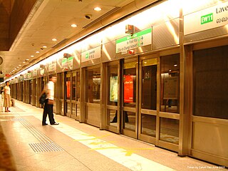
Lavender MRT station is an underground Mass Rapid Transit (MRT) station on the East West line in Kallang, Singapore. Located under Kallang Road, the station is close to the Immigration and Checkpoints Authority (ICA) Building, Golden Mile Complex and Jalan Besar Stadium. Planned and built as part of Phase Two of the original MRT network, the contract for the station's construction was awarded in October 1985, and it was opened in November 1989.

Mountbatten MRT station is an underground Mass Rapid Transit (MRT) station on the Circle line, located on the boundary of Kallang and Geylang, Singapore.

Dakota MRT station is an underground Mass Rapid Transit (MRT) station on the Circle line in Geylang planning area, Singapore, next to Geylang River.

Kallang Basin is an enclosed bay in Kallang, Singapore. The Kallang River, Rochor River and Geylang River empty into the Kallang Basin. The Marina Channel connects the Kallang Basin with the Singapore Straits.

Tanjong Rhu is a subzone within the planning area of Kallang, Singapore, as defined by the Urban Redevelopment Authority (URA). The perimeter of Tanjong Rhu is made up of Nicoll Highway in the north; Mountbatten Road and Fort Road in the east; East Coast Parkway (ECP) in the south; as well as Marina Channel and Kallang Basin in the west. Tanjong Rhu is the largest in terms of physical area among the nine subzones that make up Kallang.

Kallang Riverside Park is a riverine park in Kallang, Singapore. It sits on the confluence of the Kallang River and Rochor River, north of the Kallang Basin.
Bendemeer MRT station is an underground Mass Rapid Transit (MRT) station on the Downtown Line in Kallang, Singapore.

Geylang Bahru MRT station is an underground Mass Rapid Transit (MRT) station on the Downtown line in Kallang, Singapore.

Geylang Bahru is a subzone within the planning area of Kallang, Singapore, as defined by the Urban Redevelopment Authority (URA). It is bounded by the Pan Island Expressway (PIE) in the east; the Pelton Canal in the south; the Kallang River in the west; and Serangoon Road in the north.

Lavender is a subzone within the planning area of Kallang, Singapore, as defined by the Urban Redevelopment Authority (URA). Lavender is composed of an area bounded by Tessensohn Road in the north; Balestier Road, Lavender Street and Crawford Street in the east; the Rochor River and Rochor Canal in the south; as well as Syed Alwi Road, Serangoon Road and Rangoon Road in the west.

Boon Keng is a subzone within the planning area of Kallang, Singapore, as defined by the Urban Redevelopment Authority (URA). The smallest in terms of physical area among the nine subzones that make up Kallang, Boon Keng is bounded by the Pelton Canal in the north; the Kallang–Paya Lebar Expressway (KPE) and Sims Way in the east; Sims Avenue in the south; and the Kallang River in the west.

Bendemeer is a subzone within the planning area of Kallang, Singapore, as defined by the Urban Redevelopment Authority (URA). Its boundary is made up of the Pan Island Expressway (PIE) in the north; Serangoon Road, the Kallang River, Sungei Whampoa and Bendemeer Road in the east; Lavender Street and Balestier Road in the south; and the Central Expressway (CTE) in the west.

Kampong Bugis is a subzone within the planning area of Kallang, Singapore, as defined by the Urban Redevelopment Authority (URA). This subzone is bounded by Kallang Road and Sims Avenue in the north; the Kallang–Paya Lebar Expressway (KPE) and Sims Way in the east; Nicoll Highway in the south; and Crawford Street in the west.

Crawford is a subzone within the planning area of Kallang, Singapore, as defined by the Urban Redevelopment Authority (URA). Its perimeter is made up of Rochor River and Rochor Canal in the north; Crawford Street, Nicoll Highway, Kallang Basin and Marina Channel in the east; East Coast Parkway (ECP) in the south; as well as Ophir Road, Beach Road and Jalan Sultan in the west.
Kampong Java is a subzone within the planning area of Kallang, Singapore, as defined by the Urban Redevelopment Authority (URA). It is bounded by the Central Expressway (CTE) in the west; Balestier Road in the north; Tessensohn Road, Race Course Road, Gloucester Road, Northumberland Road and Tekka Lane in the east; and Bukit Timah Road in the south.
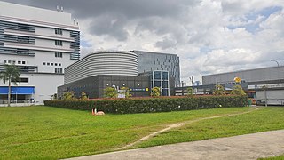
Geylang East Public Library is one of the 26 public libraries established by the National Library Board of Singapore.