Boat Quay

Last updated

Boat Quay
Subzone of Singapore River Planning Area
Name transcription(s)
   Chinese 驳船码头
   Pinyin Bóchuán Mǎtóu
   Malay Boat Quay
   Tamil போட் கீ
Boat quay sct.JPG
Aerial view of the quay
Country Singapore

Boat Quay is a historical quay in Singapore which is situated upstream from the mouth of the Singapore River on its southern bank. It spans from the shophouses near UOB Plaza, stretching along one bank of the Singapore River, all the way till Elgin Bridge.

Contents

It was the busiest part of the old Port of Singapore, handling three-quarters of all shipping business during the 1860s. Because the south of the river here resembles the belly of a carp, which according to Chinese belief is where wealth and prosperity lay, many shophouses were built, crowded into the area.

Though serving aquatic trade is no longer Boat Quay's primary role, the shophouses on it have been carefully conserved and now house various bars, pubs and restaurants. Therefore, Boat Quay's social-economic role in the city has shifted away from that of trade and maritime commerce, and now leans towards more of a role accommodated for tourism and aesthetics for the commercial zone of which encloses the Singapore River. It is the soft front to the cosmopolitan banking and financial sectors lying immediately behind it.

Boat Quay is also the name of the road along the quay, which has since been converted into a pedestrian mall.

History

The quay and the Singapore skyline at night Boat quay night 2009n.JPG
The quay and the Singapore skyline at night

During the 1800s, Boat Quay was used to transfer various goods onto cargo ships, such as porcelain, rubber and spices. Trading in Boat Quay reached a peak in the mid-1800s. [1]

Adaptive re-use of the historic buildings

Since the 1990s, Boat Quay has been transformed into a pedestrian mall with restaurants, pubs, cafes and clubs. Boat Quay 4, Dec 05.JPG
Since the 1990s, Boat Quay has been transformed into a pedestrian mall with restaurants, pubs, cafes and clubs.

The Singapore government cleaned-up the river in 1983 and moved the remaining shipping industry's lighters to a new quay near Pasir Panjang. Therefore, the Boat Quay was deserted and unused from 1983 to 1989. [1]

In 1986, the Urban Redevelopment Authority announced plans to preserve Boat Quay as part of a master plan for conserving the whole of the Singapore River and its environs.

On 7 July 1989, an area encompassing South Bridge Road, Circular Road, Lorong Telok and North Canal Road was gazetted. The two- and three-storey shophouses in that area, with their characteristic five-foot way beneath projecting upper floors, were preserved and transformed into new businesses. The shophouses and godowns along the river bank were restored in the 1990s and are now bustling shops, restaurants and bars.

When the area became a conservation area in 1989, redevelopment began and by 1993 all historic shophouses were under reconstruction. The Singapore Urban Redevelopment Authority issued stringent guidelines for the restoration but did not provide cash grants or tax relief for conservation projects but waived some of the development charges, car parking requirements and car park deficiency charges. [1]

The historic shophouses could now easily be re-used for modern businesses, such as restaurants, cafes, bars and small shops. The interior of the buildings could be modified with the new use in mind, in some cases using new non-traditional interior ornamentation, materials, and colours. For instance, the interior of the Opera Cafe at No. 40 Boat Quay was modified to create an ambiance similar to an opera stage-set. The ground floor of the Lim Family Shophouse at No. 58 Boat Quay was converted into a Japanese restaurant. The upper floor is used as a weekend flat for the Lim family, who lived in the building since 1908. The architect Mok Wei Wei created more open space by demolishing some of the original partition walls, but kept and restored the original teak floors, paint colour on the window frames, wooden balcony doors, and tile roofs. The historic blackwood furniture and art pieces were also restored and re-used. [1]

Multiple startup companies also rent offices around the Boat Quay and nearby Circular Road area.

See also

Literature

Related Research Articles

<span class="mw-page-title-main">Geylang</span> Planning Area and HDB Town in Central Region, Singapore

Geylang is a planning area and township located on the eastern fringe of the Central Region of Singapore, bordering Hougang and Toa Payoh in the north, Marine Parade in the south, Bedok in the east, and Kallang in the west.

<span class="mw-page-title-main">Chinatown, Singapore</span> Neighborhood in Singapore, subzone of Outram

Chinatown is a subzone and ethnic enclave located within the Outram district in the Central Area of Singapore. Featuring distinctly Chinese cultural elements, Chinatown has had a historically concentrated ethnic Chinese population.

<span class="mw-page-title-main">Raffles Place</span> Place in Singapore

Raffles Place is the centre of the Financial District of Singapore and is located south of the mouth of the Singapore River. It was first planned and developed in the 1820s as Commercial Square to serve as the hub of the commercial zone of Singapore in Raffles Town Plan. It was renamed Raffles Place in 1858 and is now the site of a number of major banks. It is located in the Downtown Core within the Central Area, and features some of the tallest buildings and landmarks of the country.

<span class="mw-page-title-main">Tanjong Pagar</span> Historic district in Singapore

Tanjong Pagar is a historic district located within the Central Business District of Singapore, straddling the Outram Planning Area and the Downtown Core under the Urban Redevelopment Authority's urban planning zones. The district has a rich history and is known for its cultural and architectural landmarks, making it a popular tourist destination.

<span class="mw-page-title-main">Kampong Glam</span> Neighborhood within Rochor Planning Area, Central Region, Singapore

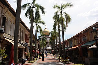
Kampong Glam is a neighbourhood and ethnic enclave in Singapore. It is located north of the Singapore River, in the planning area of Rochor, known as the Malay-Muslim quarter.

<span class="mw-page-title-main">Clarke Quay</span> Subzone of Singapore River Planning Area

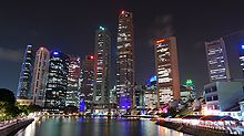
Clarke Quay is a historical riverside quay in Singapore, located within the Singapore River Planning Area. The quay is situated upstream from the mouth of the Singapore River and Boat Quay.

<span class="mw-page-title-main">Geylang Road</span> Trunk road in East Singapore linked to the central district

Geylang Road is a major trunk road linking Singapore's eastern suburban areas with the country's central business district. Deriving its name from the area of Geylang where the road cuts through, it is fronted on both sides by low-rise shophouses protected statutorily from urban redevelopment in keeping with its history and urban heritage.

<span class="mw-page-title-main">Old Ministry of Labour Building</span>

The Old Ministry of Labour Building is a former building of the Ministry of Labour located at Havelock Square in the Outram Planning Area, within the Central Area of Singapore's central business district. The building once housed the former Chinese Protectorate which was first established in 1877 to protect and control Chinese immigrants to Singapore. The building had since been restored in 1990 and currently used as the Family and Juvenile Court of Singapore.

<span class="mw-page-title-main">New Bridge Road</span> Road in Singapore

New Bridge Road is a major one-way road located within the Central Area in Singapore.

<span class="mw-page-title-main">Bukit Pasoh Road</span>

Bukit Pasoh Road is a road in Tanjong Pagar within the Outram Planning Area of Singapore. The road starts from Neil Road which is one way, but becomes two ways, when the road forks out into two parts, with one becoming Teo Hong Road, with both roads ending at New Bridge Road. The road is mainly lined with conserved shophouses and houses a high-end boutique hotel known as the New Majestic Hotel.

<span class="mw-page-title-main">Keong Saik Road</span>

Keong Saik Road is a one-way road located in Chinatown within the Outram Planning Area in Singapore. The road links New Bridge Road to Neil Road, and is intersected by Kreta Ayer Road.

<span class="mw-page-title-main">Tras Street</span>

Tras Street is a street located in Tanjong Pagar in the Outram Planning Area and Downtown Core in Singapore. The road connects Enggor Street and Gopeng Street to Cook Street, and is intersected by Wallich Street.

<span class="mw-page-title-main">Duxton Hill</span>

Duxton Hill is a small hill, as well as the name of a road, located in Tanjong Pagar in the Downtown Core district of Singapore.

<span class="mw-page-title-main">Gedung Kuning</span> Mansion in Kampong Glam, Singapore

Gedung Kuning is a Malay historical residence in Singapore. Located at 73 Sultan Gate, Gedung Kuning stands just outside the Malay Heritage Centre, near Masjid Sultan in the historic district of Kampong Glam in Singapore. However, from 1919 to 1925, the Gedung Kuning's address was 33 Sultan Gate. Once forming an annexe to the adjacent palace of Singapore's Malay rulers, Istana Kampong Glam, it became the private residence of Haji Yusoff, a prominent Malayo-Javanese merchant and four generations of his family. Together with the Istana, the compound was refurbished as part of the development of the Malay Heritage Centre in 2004.

<span class="mw-page-title-main">The Scarlet Singapore</span> Building in Erskine Road Singapore

The Scarlet Singapore is a luxury boutique hotel located at Erskine Road, Chinatown, Singapore. Opened in 2004, The Scarlet Singapore contains 80 rooms and is managed by Singapore-based hospitality management group Grace International.

<span class="mw-page-title-main">The Concourse</span> Commercial and Residential in Beach Road, Singapore

<span class="mw-page-title-main">The Fullerton Hotel Singapore</span> Hotel in Singapore

The Fullerton Hotel Singapore is a five-star luxury hotel located near the mouth of the Singapore River, in the Downtown Core of the Central Area, Singapore. It was originally known as the Fullerton Building, and also as the General Post Office Building. The address is 1 Fullerton Square. The Fullerton Building was named after Robert Fullerton, the first Governor of the Straits Settlements (1826–1829). Commissioned in 1924 as part of the British colony's centennial celebrations, the building was designed as an office building by Major P.H. Keys of Keys & Dowdeswell, a Shanghai firm of architects, which won the project through an architectural design competition. The architectural firm also designed the Capitol Theatre, its adjoined Capitol Building and the Singapore General Hospital. In 2015, it was designated as a national monument of Singapore.

<span class="mw-page-title-main">Gallery Hotel</span> Building in Singapore River, Singapore

Gallery Hotel was a four-star boutique hotel at Robertson Quay on Singapore River, in the Central Area of Singapore. Originally known as Gallery Evason Hotel, it was the first "HIP" hotel in Singapore, and the second in Asia, the first being in Japan.

<span class="mw-page-title-main">Robertson Quay</span> Port in Singapore

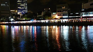
Robertson Quay is a wharf near the source of the Singapore River. It is the largest and most upstream of the three wharfs on the river and is named after a municipal counsellor Dr J Murray Robertson. It now has al fresco dining as well as arts and culture.

<span class="mw-page-title-main">Peranakan Place</span>

Peranakan Place, formerly known as Peranakan Corner, is a row of six two-storey shophouses facing Orchard Road, built around 1902 at the intersection of Emerald Hill Road and Orchard Road in the planning area of Newton in Singapore. It forms part of the Emerald Hill Conservation Area within the Orchard district in central Singapore.

References

  1. 1 2 3 4 5 Eunice M. Lin Adaptive Re-use of the Historic Boat Quay Singapore River, Singapore.

1°17′12.65″N103°50′58.24″E / 1.2868472°N 103.8495111°E / 1.2868472; 103.8495111