
Geylang is a planning area and township located on the eastern fringe of the Central Region of Singapore,bordering Hougang and Toa Payoh in the north,Marine Parade in the south,Bedok in the east,and Kallang in the west.

Kallang is a planning area and residential zone located in the Central Region of Singapore.

The Pan Island Expressway is the oldest and longest expressway in Singapore. It is also Singapore's longest road. The expressway runs from the East Coast Parkway near Changi Airport in the east to Tuas in the west and has a total length of 42.8 kilometres.

The Kallang River is the longest river in Singapore,flowing for 10 kilometers from the Lower Peirce Reservoir to the Kallang Basin. It originates in the planning area of Central Water Catchment,flows in a southeast direction through Bishan and Toa Payoh,before finally arriving in Kallang.
Bukit Merah,also known as Redhill,is a planning area and new town situated in the southernmost part of the Central Region of Singapore. The planning area borders Tanglin to the north,Queenstown to the west and the Downtown Core,Outram and Singapore River planning areas of the Central Area to the east. It also shares a maritime boundary with the Southern Islands planning area to the south. Bukit Merah is linked to Sentosa Island via Sentosa Gateway,Sentosa Broadwalk,Sentosa Express and the Cable Car.

Boon Lay is a neighbourhood located in the town of Jurong West in the West Region of Singapore. Its borders very roughly correspond to the URA subzone of Boon Lay Place,situated within the Jurong West Planning Area.

Boon Keng MRT station is an underground Mass Rapid Transit (MRT) station on the North East line in Kallang,Singapore.

Jalan Besar Group Representation Constituency is a four-member Group Representation Constituency composed of several city suburbs along with the Central Area of Singapore. The Jalan Besar GRC is the electoral division representing the largest area of the downtown city centre of Singapore,followed by Tanjong Pagar GRC. There are four wards in the GRC:Kreta Ayer-Kim Seng,Kolam Ayer,Whampoa and lastly Kampong Glam managed by Jalan Besar Town Council. The current Members of Parliament are Denise Phua,Wan Rizal,Josephine Teo and Heng Chee How from the People's Action Party (PAP).

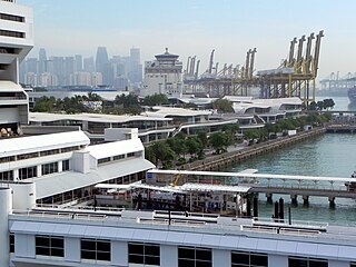
Kallang Basin is an enclosed bay in Kallang,Singapore. The Kallang River,Rochor River and Geylang River empty into the Kallang Basin. The Marina Channel connects the Kallang Basin with the Singapore Straits.

Geylang East,as a planning subzone,covers what is more commonly known as Eunos. This is located in Geylang zone in the Central Region of Singapore. The vicinity is served by both Paya Lebar and Eunos MRT stations. This area is distinct from the Geylang East Central and estate,which is adjacent to and west of Eunos.

Kampong Ubi,also known as Ubi Estate,is a subzone located in the planning area of Geylang in the Central Region of Singapore. It lies within a somewhat rhombic piece of land bounded by Airport Road at the north,the Pan-Island Expressway at the south,Eunos Link at the east and Paya Lebar Road at the west. The area was formerly a Malay village.
Woodsville Interchange is a major road interchange in Singapore. It marks the triple-point boundary of the planning areas of Kallang,Geylang and Toa Payoh.
Bendemeer MRT station is an underground Mass Rapid Transit (MRT) station on the Downtown line in Kallang,Singapore.
Kallang Bahru is a subzone within the planning area of Kallang,Singapore,as defined by the Urban Redevelopment Authority (URA). This subzone is bounded by Bendemeer Road and Sungei Whampoa in the north;the Kallang River in the east;Kallang Road and Sims Avenue in the south;and Lavender Street in the west.

Lavender is a subzone within the planning area of Kallang,Singapore,as defined by the Urban Redevelopment Authority (URA). Lavender is composed of an area bounded by Tessensohn Road in the north;Balestier Road,Lavender Street and Crawford Street in the east;the Rochor River and Rochor Canal in the south;as well as Syed Alwi Road,Serangoon Road and Rangoon Road in the west.

Boon Keng is a subzone within the planning area of Kallang,Singapore,as defined by the Urban Redevelopment Authority (URA). The smallest in terms of physical area among the nine subzones that make up Kallang,Boon Keng is bounded by the Pelton Canal in the north;the Kallang–Paya Lebar Expressway (KPE) and Sims Way in the east;Sims Avenue in the south;and the Kallang River in the west.
Moulmein–Kallang Group Representation Constituency was a four-member Group Representation Constituency (GRC),comprising several city suburbs surrounding the Central Area of Singapore as well as a sizeable portion of the Central Business District. It existed from 2011 to 2015.

Bendemeer is a subzone within the planning area of Kallang,Singapore,as defined by the Urban Redevelopment Authority (URA). Its boundary is made up of the Pan Island Expressway (PIE) in the north;Serangoon Road,the Kallang River,Sungei Whampoa and Bendemeer Road in the east;Lavender Street and Balestier Road in the south;and the Central Expressway (CTE) in the west.


