
The Johor Strait is an international strait in Southeast Asia, between Singapore and Peninsular Malaysia.

Jurong is a major geographical region located at the south-westernmost point of the West Region of Singapore. Although mostly vaguely defined, the region's extent roughly covers the planning areas of Jurong East, Jurong West, Boon Lay, and Pioneer, along with Jurong Island in the Western Islands cluster and the southernmost portions of the Western Water Catchment. Should it be described at its greatest historical extent, the region can also include present-day Bukit Batok and Tuas.

Pulau Tekong, also known colloquially as Tekong or Tekong Island, is the second-largest of Singapore's outlying islands after Jurong Island. Tekong is located off Singapore's northeastern coast, east of Pulau Ubin. Since the 1990s, the island has been used by the Singapore Armed Forces (SAF) and is generally restricted from public access. Transport to the island for permitted persons is via the SAF Changi Ferry Terminal at Changi Beach.

Land reclamation, often known as reclamation, and also known as land fill, is the process of creating new land from oceans, seas, riverbeds or lake beds. The land reclaimed is known as reclamation ground, reclaimed land, or land fill.

Singapore is a city-state and island country in maritime Southeast Asia, located at the end of the Malayan Peninsula between Malaysia and Indonesia as well as the Straits of Malacca and the South China Sea. It is heavily compact and urbanised. As of 2023, Singapore has a total land area of approximately 750 square kilometres (290 sq mi). Singapore is separated from Indonesia by the Singapore Strait and from Malaysia by the Straits of Johor.

Tuas is a planning area located within the West Region of Singapore. It is bounded by the Western Water Catchment to its north, Pioneer to its east and the Straits of Johor to its west. Tuas also shares a maritime boundary with the Western Islands planning area to its east.

The Esplanade is a waterfront location just north of the mouth of the Singapore River in downtown Singapore. It is primarily occupied by the Esplanade Park, and was the venue for one of Singapore's largest congregation of satay outlets until their relocation to Clarke Quay as a result of the construction of a major performance arts venue, the Esplanade - Theatres on the Bay, which took its name from this location.

Pasir Panjang is an area located at the southern part of Queenstown in Singapore. Kent Ridge Park is a topographical feature which runs adjacent to Pasir Panjang.
Water supply and sanitation in Singapore are intricately linked to the historical development of Singapore. It is characterised by a number of outstanding achievements in a challenging environment with geographical limitations. Access to water in Singapore is universal, affordable, efficient and of high quality.

The West Region of Singapore is one of the five regions in the city-state. The region is the largest in terms of land area and is the third most populous region after the North-East Region and Central Region. Jurong East is the regional centre of the region, with plans of developing the Jurong Lake District into a second CBD area. Jurong West is the most populous town in the region, with a population of 262,730 residents. Comprising 25,500 hectares of land area, it includes twelve planning areas and is home to about 922,540 residents.

The Malaysia–Singapore border is an international maritime border between the Southeast Asian countries of Malaysia, which lies to the north of the border, and Singapore to the south. The boundary is formed by straight lines between maritime geographical coordinates running along or near the deepest channel of the Straits of Johor.

HarbourFront is a waterfront district situated in southern Singapore. Whilst HarbourFront's boundaries are ambiguous, its location is roughly represented on the URA's Master Plan as a subzone called Maritime Square, located within the Bukit Merah Planning Area.

This article shows the notable future developments in Singapore. Most of them are currently under construction with most to be completed within the next five years.
PUB, Singapore's National Water Agency, commonly known as PUB, an acronym for Public Utilities Board, is a statutory board under the Ministry of Sustainability and the Environment of the Government of Singapore responsible for ensuring a sustainable and efficient water supply in Singapore.

Singapore Island, also known as mainland Singapore, is the main constituent island of the sovereign island country and city-state of the Republic of Singapore. It is located at the southern tip of Malay Peninsula, in-between the Straits of Malacca and the South China Sea. The Singapore Strait lies to the south, while the Johor Strait lies to the north.
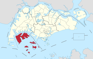
The Western Islands is a planning area located within the West Region of Singapore. It comprises a collection of islands located in the south-western waters of Singapore, namely Jurong Island, Pulau Bukom and Sudong Islands.
Pioneer Sector is part of the Jurong Industrial Estate which is the largest industrial estate in Singapore.

Gul Circle MRT station is an elevated Mass Rapid Transit (MRT) station on the East–West Line (EWL). Located in Tuas, western Singapore, the station serves the surrounding industries of JTC Space @ Tuas and Mapletree Pioneer Logistic Hub. The station is operated by SMRT Trains.

Tuas Link MRT station is an elevated Mass Rapid Transit (MRT) station in western Singapore. Located in Tuas along Tuas West Drive, it is located close to Tuas Depot and Tuas Checkpoint. The station is the terminus of the East–West line (EWL) and the westernmost station in Singapore.
Tuas Lamp Post 1 is a cycling attraction in Singapore. It is the only lamp post in Singapore on which it is legal to paste stickers. This has led to it being covered in stickers as high as 10 meters up. It is located on Tuas South Boulevard, near the Tuas Mega Port, about 13km from the Tuas Checkpoint.