
Sembawang is a planning area and residential town located in the North Region of Singapore. Sembawang planning area is bordered by Simpang to the east, Mandai to the south, Yishun to the southeast, Woodlands to the west and the Straits of Johor to the north.

Pasir Ris is a planning area and residential town located in the East Region of Singapore. It is bordered by Tampines and Paya Lebar to the south, Sengkang to the southwest and Changi to the east. The planning area also shares riverine boundary with Punggol to the west, separated by the Serangoon River, as well as having a maritime boundary with the North-Eastern Islands planning area, across the Straits of Johor.

Tampines is the regional centre of the East Region of Singapore. With a population of 265,340 living across its five subzones, it is the second-most populous planning area in Singapore, according to the DOS Population Trends 2022. It is home to approximately 5% of Singapore's population. Tampines is bordered to the west by Bedok and Paya Lebar, to the north by Pasir Ris, to the east by Changi, and to the south by the Straits of Singapore. Situated in the historical region of Tanah Merah, its present-day terrain is particularly flat due to the large-scale sand quarrying in the 1960s.

Yishun, formerly known as Nee Soon, is a residential town located in the northeastern corner of the North Region of Singapore, bordering Simpang and Sembawang to the north, Mandai to the west, the Central Water Catchment to its southwest, Ang Mo Kio to its south, as well as Seletar and Sengkang to its east and southeast respectively.

Bedok is a planning area and residential town located in the geographical region of Tanah Merah along the south-eastern coast of the East Region of Singapore. Bedok is bounded by five other planning areas: Paya Lebar to the north, Hougang to the northwest, Tampines to the northeast and east, Geylang to the west and Marine Parade to the southwest. It also shares a maritime boundary with the Singapore Strait to the south and southeast.
Seletar is an area located in the north-east of Singapore. Its name can also refer to the Seletar Planning Area, situated in the North-East Region of Singapore. The place name was derived from the Malay subgroup who were indigenous to the area, the Orang Seletar. It shares boundaries with the planning areas of Sengkang to the south, Punggol to the east, Yishun and Simpang to the west, as well as the Straits of Johor to the north.

Bedok Reservoir is a reservoir in the eastern part of Singapore, to the north of Bedok. The reservoir has a surface area of 880,000 m², and a capacity of 12.8 million m³. The mean depth of the reservoir is 9 m, with a maximum depth of 18.2 m. The shoreline length is 4.3 km.

Changi Village is a modern village situated at the northern tip of Changi which is at the eastern end of Singapore. It is the usual connecting point for travellers heading to Pulau Ubin or Malaysia by ferry. Fishermen in the kelongs located in the Serangoon Harbour offshore also use this jetty as a drop off point to come onto mainland. Changi Village also has many resorts and leisure facilities to cater for a weekend getaway for many Singaporeans. The area is classified by Urban Redevelopment Authorities as under the planning area of Changi and in the subzone of Changi Point. It is also classified under District 17 for property indexing.

Lower Seletar Reservoir is a reservoir located in the northern part of Singapore in the Lower Seletar subzone, located in Yishun New Town. The reservoir has a surface area of 3.6 km², and a capacity of 9.5 million m³. The mean depth of the reservoir is 2 m, with a maximum depth of 5.5 m. The shoreline length is 14.3 km.
The North Region of Singapore is one of the five regions in the city-state. The region is the second largest region in terms of land area, and has a population of 582,330. Woodlands is the regional centre and also the most populous town with 255,130 residents living in the area. Comprising 13,500 hectares of land area, it includes eight planning areas.
Fernvale is a neighbourhood of Sengkang New Town in Singapore. It is located between Sungei Punggol and the proposed Sengkang West Industrial Estate. The house numbers of the public apartment blocks in Fernvale begin with the number '4' (4xx). Fernvale is the newest neighbourhood in Sengkang Town to be completed by the Housing and Development Board (HDB). Seletar Mall, a new shopping amenity which houses Sengkang's first cineplex, is located within this neighbourhood. In 2017, a proposed community facility to be located next to Seletar Mall was announced, which houses a community club, childcare centre, hawker centre and wet market. The community facility which was slated to be ready by the second half of 2020, had stopped construction in April 2020 due to the COVID-19 measures set by the government. Construction of the facility has since continued in the second half of 2020 and was completed in 2022.

Sengkang is a planning area and residential town located in the North-East Region of Singapore. The town is the second most populous in the region, being home to 249,370 residents in 2020. Sengkang shares boundaries with Seletar and Punggol in the north, Pasir Ris and Paya Lebar in the east, Hougang and Serangoon to the south, as well as Yishun and Ang Mo Kio to the west.

Upper Seletar Reservoir is Singapore's third impounding reservoir, after MacRitchie Reservoir and Peirce Reservoir. It is located within the Central Water Catchment area of Singapore island.

This article shows the notable future developments in Singapore. Most of them are currently under construction with most to be completed within the next five years.
Tanah Merah, is a geographical region located along the south-eastern coast of the East Region of Singapore. Although its boundaries are not exactly clear, it is widely accepted that the term refers to the southern coast of present-day Bedok, Tampines, Changi and Changi Bay.

The Western Water Catchment is a planning area located in the West Region of Singapore. The planning area borders Tuas and Pioneer to its south, Sungei Kadut, Choa Chu Kang and Tengah to its east, Jurong West to its southeast, Lim Chu Kang to its north and the Straits of Johor to its west. It is the largest planning area by land area, covering nearly a tenth of Singapore Island. It is also one of the two main water catchments in Singapore, the other being Central Water Catchment.
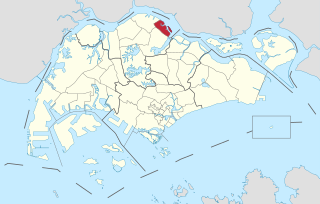
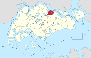
Simpang, is a planning area located in the North Region of Singapore. The word Simpang means junction or intersection in Malay. It is situated north of Yishun, east of Sembawang and west of Seletar. Pulau Seletar is classified under Simpang planning area. Jalan Kuala Simpang was the main road serving the area. Sungei Simpang Kiri, Sungei Simpang Kanan and Simpang Kiri Park Connector retain and reflect the name of the area.

Sungei Bedok MRT station is a future underground Mass Rapid Transit interchange and terminal station on the Downtown line and Thomson–East Coast line in Bedok planning area, Singapore. The station is being built east of where Upper East Coast Road becomes Bedok Road, and will serve residents of the Eastwood estate. Nearby facilities include the Bedok Food Centre, Eastwood Centre and the Laguna National Golf & Country Club.


