
Changi is a planning area located in the geographical region of Tanah Merah in the East Region of Singapore. Sharing borders with Pasir Ris and Tampines to the west, Changi Bay to the southeast, the South China Sea to the east and the Serangoon Harbour to the north. Changi, excluding the two water catchments and islands of Singapore, is the largest planning area by land size.

Pulau Ubin, also simply known as Ubin, is an island situated in the north east of Singapore, to the west of Pulau Tekong. The granite quarry used to be supported by a few thousand settlers on Pulau Ubin in the 1960s, but only about 38 villagers remained as of 2012. It is one of the last rural areas to be found in Singapore, with an abundance of natural flora and fauna. The island forms part of the Ubin–Khatib Important Bird Area (IBA), identified as such by BirdLife International because it supports significant numbers of visiting and resident birds, some of which are threatened. Today, the island is managed by the National Parks Board, compared to 12 agencies managing different areas of the island previously.

Pasir Ris is a planning area and residential town located in the East Region of Singapore. It is bordered by Tampines and Paya Lebar to the south, Sengkang to the southwest and Changi to the east. The planning area also shares riverine boundary with Punggol to the west, separated by the Serangoon River, as well as having a maritime boundary with the North-Eastern Islands planning area, across the Straits of Johor.

Kallang is a planning area and residential town located in the Central Region of Singapore.
Kembangan is a subzone and residential precinct located in the town of Bedok in the East Region of Singapore. It consists largely of private residential areas and a small public housing estate along Lengkong Tiga.

Queenstown is a planning area and satellite residential town situated on the south-westernmost fringe of the Central Region of Singapore. It borders Bukit Timah to the north, Tanglin to the northeast, Bukit Merah to the east and southeast, as well as Clementi to the northwest and west. Its southern and southwesternmost limits are bounded by the Pandan Strait.

Tuas is a planning area located within the West Region of Singapore. It is bounded by the Western Water Catchment to its north, Pioneer to its east and the Straits of Johor to its west. Tuas also shares a maritime boundary with the Western Islands planning area to its east.

Kusu Island is one of the Southern Islands in Singapore, located about 5.6 kilometres to the south of the main island of Singapore and below the Singapore Straits. "Kusu" means "Tortoise Island" or "Turtle Island" in Hokkien; the island is also known as Peak Island or Pulau Tembakul in Malay.
Bukit Merah, often abbreviated as Bt Merah, is a planning area and new town situated in the southernmost part of the Central Region of Singapore. The planning area borders Tanglin to the north, Queenstown to the west and the Downtown Core, Outram and Singapore River planning areas of the Central Area to the east. Bukit Merah also shares a maritime boundary with the Southern Islands planning area located beyond its southernmost point. Bukit Merah is the most populated planning area in the Central Region, and the 12th most populated planning area in the country overall, being home to more than 150,000 residents.

Boon Lay is a neighbourhood located in the town of Jurong West in the West Region of Singapore. Its borders very roughly correspond to the URA subzone of Boon Lay Place, situated within the Jurong West Planning Area.

Siglap is a neighbourhood located in Bedok in the East Region of Singapore. The area also encompasses the Frankel and Opera Estates and their names have sometimes been used interchangeably to refer to the approximate same area. The planning subzone area of Siglap as defined by the Urban Redevelopment Authority (URA) is confusingly and inaccurately referred to as the small strip of land between Victoria Junior College and Bedok South Avenue 1. It is a residential area where a majority live in landed homes such as freehold semi-detached houses and bungalows. Some of the land parcels near Siglap Centre have been redeveloped into serviced apartments and condominiums. The few Housing and Development Board flats in Siglap have been demolished in 2015 under the Selective En bloc Redevelopment Scheme. The East Coast Park is also located nearby, across the East Coast Parkway.
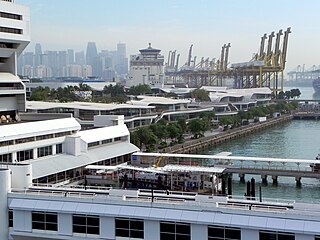
Changi Village is a modern village situated at the northern tip of Changi which is at the eastern end of Singapore. It is the usual connecting point for travellers heading to Pulau Ubin or Malaysia by ferry. Fishermen in the kelongs located in the Serangoon Harbour offshore also use this jetty as a drop off point to come onto mainland. Changi Village also has many resorts and leisure facilities to cater for a weekend getaway for many Singaporeans. The area is classified by Urban Redevelopment Authorities as under the planning area of Changi and in the subzone of Changi Point. It is also classified under District 17 for property indexing.

The East Region of Singapore is one of the five regions in the city-state. The region is the 2nd most densely populated among the five, and has the smallest land area. Bedok is the region's most populous town and Tampines is the regional centre of the area. Comprising 11,000 hectares, it includes six planning areas and is also home to Singapore's Changi Airport and Paya Lebar Airbase

Pasir Ris Park is a beach park located in the eastern part of Singapore. It covers an area of 70 hectares, and was partially built on reclaimed land. Initially planned in the late 1970s to serve people living in the vicinity, the park was designed with the help of two Japanese landscape specialists. Construction began on the park in September 1984, and the park was opened in phases from August 1986 to 1991. The park was further expanded in 2007, with the addition of new areas such as a herb garden.
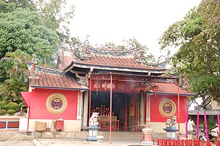
Tua Pek Kong is a deity in the pantheon of Peranakan folk religion practiced by ethnic Chinese in Malaysia, Singapore, and parts of Indonesia.

Balestier is a sub zone located in the planning area of Novena in the Central Region of Singapore. The main road, Balestier Road, links Thomson Road to Serangoon Road and the road continues on as Lavender Street. The area is home to rows of shophouses, such as the Sim Kwong Ho Shophouses, the Balestier Art Deco Shophouses, 412-418 Balestier Road, and 601-639 Balestier Road, low-rise apartments and commercial buildings as well as a shopping mall known as Shaw Plaza. However, Shaw Plaza has since closed down and is under construction. Balestier also has another mall, Zhongshan Mall. There are several lighting and electrical shops along Balestier Road, which is also home to the Ceylon Sports Club and the Indian Association. The area is known for its food such as bak kut teh and chicken rice. In the area, there are several apartments, condominiums, and budget hotels.

Kampong Ubi, also known as Ubi Estate, is a subzone located in the planning area of Geylang in the Central Region of Singapore. It lies within a somewhat rhombic piece of land bounded by Airport Road at the north, the Pan-Island Expressway at the south, Eunos Link at the east and Paya Lebar Road at the west. The area was formerly a Malay village.

Sree Ramar Temple is a temple for the Hindu god Rama, who is the presiding deity. It is located at the junction of Changi Village Road and Loyang Avenue in the east of Singapore.
