The Pertubuhan Kebangsaan Melayu Singapura is a political party in Singapore.

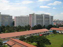
Geylang is a planning area and township located on the eastern fringe of the Central Region of Singapore,bordering Hougang and Toa Payoh in the north,Marine Parade in the south,Bedok in the east,and Kallang in the west.

Kallang is a planning area and residential zone located in the Central Region of Singapore.
Kembangan is a subzone and residential precinct located in the town of Bedok in the East Region of Singapore. It consists largely of private residential areas and a small public housing estate along Lengkong Tiga.
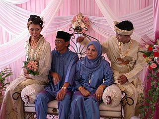
Malay Singaporeans are an umbrella term for the indigenous ethnic groups of Maritime Southeast Asia-origin who adhered to the religion of Islam and settled in Singapore. The Singaporean Malays constitute approximately 15% of the country's citizens,making them the second largest ethnic group in Singapore. Under the Constitution of Singapore,they are recognised by the government as the indigenous people of the country,with Malay as the ethnosocial language.
Aljunied is a sub-urban area located in the central part of the city-state of Singapore. Named after Aljunied Road,it was formerly agricultural land which has since been heavily urbanised and presently comprises a variety of land uses. Today,Aljunied is a bustling neighbourhood with HDB flats with amenities like shops,schools,parks and recreational facilities,as well as quite a number of traditional Singaporean shophouses.
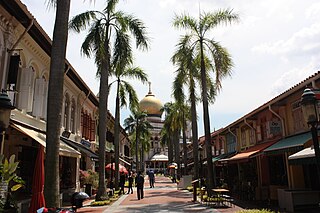
Kampong Glam is a neighbourhood and ethnic enclave in Singapore. It is located north of the Singapore River,in the planning area of Rochor,known as the Malay-Muslim quarter.

Siglap is a neighbourhood located south-west of Bedok in the East Region of Singapore. The area encompasses the Frankel and Opera Estates and their names have sometimes been used interchangeably to refer to the approximate same area. The planning subzone area of Siglap,as defined by the Urban Redevelopment Authority (URA),is confusingly and inaccurately referred to as the small strip of land between Victoria Junior College and Bedok South Avenue 1.

Eunos MRT station is an above-ground Mass Rapid Transit (MRT) station on the East West MRT Line in Geylang,Singapore. It is located next to the Eunos Bus Interchange.
The Malay Village,predecessor of present day Wisma Geylang Serai,was a museum once located in Geylang,Singapore,where they showcases the life of the Malays who used to live in the area before redevelopment in the 1960s.

The 1964 race riots in Singapore involved a series of communal race-based civil disturbances between the Malays and Chinese in Singapore following its merger with Malaysia in 1963,and were considered to be the "worst and most prolonged in Singapore's postwar history". The term is also used to refer specifically to two riots on 21 July 1964 and 2 September 1964,particularly the former,during which 23 people died and 454 others suffered severe injuries.

Kampong Ubi,also known as Ubi Estate,is a subzone located in the planning area of Geylang in the Central Region of Singapore. It lies within a somewhat rhombic piece of land bounded by Airport Road at the north,the Pan-Island Expressway at the south,Eunos Link at the east and Paya Lebar Road at the west. The area was formerly a Malay village.
Masjid Al-Abdul Razak is a mosque in Singapore,located at Jalan Ismail,off Jalan Eunos. The mosque is accessible from Eunos MRT station.
The family of Al-Saggoff'

Geylang Bahru is a subzone within the planning area of Kallang,Singapore,as defined by the Urban Redevelopment Authority (URA). It is bounded by the Pan Island Expressway (PIE) in the east;the Pelton Canal in the south;the Kallang River in the west;and Serangoon Road in the north.

Kaki Bukit is an industrial area located in Bedok in the East Region of Singapore. It is home to many high tech industrial companies and warehouses. There used to be a prison complex called Kaki Bukit Centre,which was converted to a prison school in 2000,however it has since moved to Tanah Merah and the Acacia Welfare Home now stands in its place. On the south of Kaki Bukit is Jalan Tenaga and Jalan Damai neighbourhoods of Bedok Reservoir Road. Redevelopments are in the pipeline for Kaki Bukit beyond 2030 when Paya Lebar Airbase located just north of the estate relocates to Changi. Not only would land be freed up for use but building height restrictions,that are currently in place for safety reasons because the estate is directly aligned with the airbase runway,would also be lifted. Kaki Bukit is classified by Urban Redevelopment Authority (URA) as a subzone under the planning area of Bedok,its boundaries differ from the constituency boundaries used by the Singapore Parliament.

Kampong Kiarong or commonly known as Kiarong,is a village in Brunei-Muara District,Brunei,as well as a neighbourhood in the country's capital Bandar Seri Begawan. It has an area of 383.43 hectares;the population was 4,530 in 2016.

Jalan Kubor Cemetery,sometimes called Victoria Street Cemetery,is a historical royal Muslim cemetery located at Victoria Street,near Kampong Glam neighbourhood in Singapore. It is one of the oldest Muslim cemeteries in Singapore and houses many graves of important Muslim figures from the 19th and 20th centuries. The cemetery features tombstones with inscriptions in a diversity of languages and writing systems,reflecting the indigenous peoples of Singapore,including Malay,Javanese script,Buginese Lontara script,Arabic,English,Mandarin and Gujarati.

Mohamed Eunos bin Abdullah was a pioneer of modern Malay journalism and leader of the Malay community of Singapore. He was the first Malay member of the Municipal Commission of Singapore and the Legislative Council of the Straits Settlements. He was also the founder of Kesatuan Melayu,a political organisation.