Paya Lebar MRT station

Last updated

 EW8  CC9 
Paya Lebar
巴耶利峇
பாய லேபார்
Mass Rapid Transit (MRT) interchange
(SGP-Singapore) Paya Lebar MRT Station Exit D 2024-02-17.jpg
Exit D of Paya Lebar station
General information
Location30 Paya Lebar Road
Singapore 409006 (EWL)
15 Paya Lebar Road
Singapore 409049 (CCL)
Coordinates 1°19′04″N103°53′33″E / 1.317767°N 103.892381°E / 1.317767; 103.892381
Owned by Land Transport Authority
Operated by SMRT Trains Ltd (SMRT Corporation)
Line(s)
Platforms6 (3 island platforms)
Tracks2 (East West line)
3 (Circle line) - 2 in regular operation
ConnectionsBus, Taxi
Construction
Structure typeElevated (East West line)
Underground (Circle line)
Platform levels2
ParkingYes (Paya Lebar Square, SingPost Centre, Paya Lebar Quarter)
Bicycle facilitiesYes
AccessibleYes
Other information
Fare zone2
History
Opened4 November 1989;34 years ago (1989-11-04) (East West line)
17 April 2010;14 years ago (2010-04-17) (Circle line)
ElectrifiedYes
Services
Preceding station Mass Rapid Transit Following station
Eunos
towards Pasir Ris
East–West Line Aljunied
towards Tuas Link
Dakota Circle Line MacPherson
towards HarbourFront
Location
SGMRT-LRT (zoom) map.svg
Red Dot.svg
Paya Lebar
Paya Lebar station in Singapore

Paya Lebar MRT station is a Mass Rapid Transit (MRT) interchange station on the East West line (EWL) and Circle line (CCL) in Geylang, Singapore. Despite the name, this station is not located in Paya Lebar but rather along Paya Lebar Road, near the junction with Sims Avenue. It is located among the developments of the Paya Lebar Central commercial hub and near the Geylang Serai district.

Contents

The station opened on 4 November 1989 as part of the MRT eastern line extension to Tanah Merah station. The EWL station exterior has the characteristic dome-shaped segmented roof also seen on other elevated EWL stations. The station later interchanges with the Circle line on 17 April 2010, and was the first MRT station to serve both an elevated line and an underground line.

History

East-West Line

East West line platforms EW8 Paya Lebar Platform A 20200808 124333.jpg
East West line platforms

The contract for the construction of Paya Lebar station and associated viaducts was awarded to Lee Kim Tah Ltd. at a contract sum of S$59.52 million in November 1985. The contractor had partnered with a French company Societe Generale D'Enterprises Sainrapt Et Brice (SGE) for the construction. The contract also includes the construction of the Kallang and Aljunied stations. [1] The station opened earlier than expected on 4 November 1989, serving the East West line. [2] [3] [4] [5] [6]

As with most of the above-ground stations along the EWL, the station was built without platform screen doors. Half-height platform screen doors, which prevent commuters from falling onto the train tracks, were installed on 28 October 2011 and commenced operations on 11 January 2012. [7] In addition, high-volume low-speed fans were installed and started operations since 14 July that year together with Kembangan station. [8] Privacy screens were installed at some parts from Paya Lebar Road all the way to Geylang East Central, to minimise the noise impact from residents since October 2016 and completed in May 2017. [9]

Circle Line

Circle line platforms CC9 Paya Lebar Platforms A and C 20200808 124203.jpg
Circle line platforms

Contract 823 for the construction of Paya Lebar station was awarded to Lum Chang Building Contractors Pte Ltd-Nishimatsu Construction Co. Ltd. joint venture at a contract sum of S$322 million. The contract also includes the construction of the Mountbatten and Dakota stations. Construction of the station started in August 2002. [10] [11] [12] [13]

On 16 March 2003, several roads around the station, including Paya Lebar Road, Eunos Avenue 5 and Tanjong Katong Road, were converted to one-way traffic to facilitate the construction. A bus stop was also temporary relocated in front of Singapore Post Centre. [14] A stretch of Sims Avenue was also temporarily realigned from 26 August 2003 until two months later. [15] When the roads were reinstated, an extra lane for each direction of Paya Lebar Road was added. [16]

The Circle line station faced a major civil engineering challenge with regard to the underpinning of two existing EWL viaduct pillars. [17] The pillars foundations were obstructing the construction works needed for the station. [13] This was the first time such an operation was conducted in Singapore, especially on a live, heavy-capacity MRT line. A concrete wall, a concrete beam and a powerful jacking device were used to transfer the load of the viaduct to other structures. It was followed by the removal of the old piles and construction of new piles to support the viaduct. Many monitoring devices were installed and key engineers looked out for any potential breaches. Additional materials and tools were on standby if the pillars start to tilt when the piles were cut, and the Land Transport Authority (LTA) worked out emergency procedures with the Singapore Civil Defence Force (SCDF). [17] The underpinning works were carried out successfully. [13]

The Circle line station opened on 17 April 2010 when the line extended to Dhoby Ghaut station. [18] [19] [20]

Incidents

On 4 April 2007, a man died after being hit by a train along the East West line sector at about 10:20 am. Police said the victim, a 52-year-old Chinese man, was pronounced dead by paramedics at 10:45 am. East-bound services were disrupted for 41 minutes but resumed by 11:02 am. [21]

Station details

Services

The station serves the EWL between the Eunos and Aljunied stations, and the CCL between the Dakota and MacPherson stations. On the EWL, the station operates between 5:47 am (6.13 am on Sundays and public holidays) and 12:22 am. On the CCL, the station operates between 5:40 am (6.07 am on Sundays and public holidays) and 12:26 am. [22] [23]

Design

The EWL station exterior before the construction of the surrounding developments. Paya Lebar MRT Station - panoramio (3).jpg
The EWL station exterior before the construction of the surrounding developments.

Like most EWL elevated stations on the eastern segment on the line (after Kallang station), Paya Lebar station has the notable feature of the dome-shaped roof, segmented like a caterpillar, over the platform level. The design was an attempt by the MRT Corporation (MRTC) to give the stations on the EWL an "attractive look". [24]

The CCL station design, like all stations on the line, takes into account certain factors such as safety, comfort and convenience, in addition to giving them a stylish modern outlook. The standardised layouts for the stations also make it simpler for commuters to navigate around. Paya Lebar station is also among the few stations with Y-shaped columns supporting the station structure. [25] In addition, there are barrier-free transfers between the EWL and CCL. The CCL station itself, like the other stations on the line, has features such as lifts and wider faregates to make them accessible for wheelchair users. [26]

The CCL station contains three platforms, however only the two outer platforms are in active operation. The middle platform is used by terminating trains before they return to the depot or occasionally trains turning back in the opposite direction. This arrangement is similar to Ang Mo Kio MRT station. [27]

Public art

Art Seats Matrix at the Paya Lebar CCL platforms. CC9 Paya Lebar CCL benches.jpg
Art Seats Matrix at the Paya Lebar CCL platforms.

The artwork The Signs of Times by Salleh Japar is showcased at the concourse level of the CCL station as part of the Art-in-Transit programme. The artwork showcases abstract pictographs reflecting the varying periods of Paya Lebar's developments from a rural village to a satellite towns. Some icons used includes pigs in a pig sty and an aeroplane taking flight from a nearby airport. [28] [29]

The station also features Art Seats, which have creative design to enhance the commuters' experience on the line. [30] Two entries were selected through the International Art Seats Design Competition in 2006. The first entry – Matrix, which received the top prize in the international competition – consists of a series of benches engraved with the name of the station in a dot-matrix style on the seat surface. Another entry, Rain, showcases steel seats in the shape of water puddles. These seats are also displayed in the other CCL interchange stations. [31]

Connectivity

The station is linked directly by underpass to multiple shopping malls in the area, including Paya Lebar Quarter and Paya Lebar Square. Malls and other building in the vicinity that are not linked directly by underpass include SingPost Centre and Lifelong Learning Institute. [32] Exit C on Paya Lebar Road provides access to Foo Hai Ch'an Monastery, Sri Sivan Temple and Masjid Wak Tanjong. Exit D on Paya Lebar Road provides access to City Plaza, Geylang Road and Wisma Geylang Serai.

See also

Related Research Articles

<span class="mw-page-title-main">Circle MRT line</span> Mass Rapid Transit line in Singapore

The Circle Line (CCL) is a medium-capacity Mass Rapid Transit line in Singapore. It runs in a loop from Dhoby Ghaut station in the city-centre to HarbourFront station in the south via Bishan station in the centre of the country. It also has a branch to Marina Bay station from Promenade station, which will be extended to HarbourFront station from 2026 to form a complete loop. Coloured orange on the rail map, the fully-underground line is approximately 35.5 kilometres (22.1 mi) long with 30 stations. Travelling from one end of the line to the other takes about an hour.

<span class="mw-page-title-main">City Hall MRT station</span> Mass Rapid Transit station in Singapore

City Hall MRT station is an underground Singapore Mass Rapid Transit (MRT) interchange station on the North–South line (NSL) and East–West line (EWL). Situated in the Downtown Core district, it is underneath Stamford Road near the road junctions with North Bridge Road and St Andrew's Road. The station is near landmarks such as the former City Hall, Raffles City, the Padang, St Andrew's Cathedral and the Cenotaph.

<span class="mw-page-title-main">Outram Park MRT station</span> Mass Rapid Transit station in Singapore

Outram Park MRT station is an underground Mass Rapid Transit (MRT) interchange station in Singapore. The station is on the East–West, North East and Thomson–East Coast lines, and is located near the junction of Outram Road, Eu Tong Sen Street and New Bridge Road on the boundary of Bukit Merah and Outram planning areas. It is the closest MRT station to Singapore General Hospital, the Police Cantonment Complex, Outram Community Hospital and the Health Promotion Board. The station was included in the early plans of the MRT network in 1982; it was constructed as part of the Phase I MRT segment from Novena, and was completed in December 1987.

<span class="mw-page-title-main">Dhoby Ghaut MRT station</span> Mass Rapid Transit station in Singapore

Dhoby Ghaut MRT station is an underground Mass Rapid Transit (MRT) interchange station on the North South, North East and Circle lines in Singapore. Located beneath the eastern end of Orchard Road shopping belt in Dhoby Ghaut, Museum Planning Area, the station is integrated with the commercial development The Atrium@Orchard. The station is near landmarks such as The Istana, the MacDonald House, Plaza Singapura and Dhoby Ghaut Green.

<span class="mw-page-title-main">HarbourFront MRT station</span> Mass Rapid Transit station in Singapore

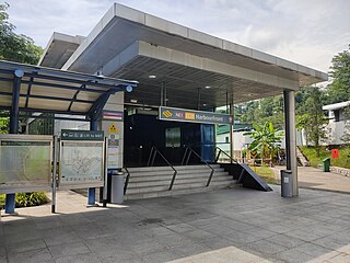
HarbourFront MRT station is an underground Mass Rapid Transit (MRT) interchange station in Singapore. The termini of the North East line (NEL) and Circle line (CCL), the station serves the HarbourFront area and Sentosa. Surrounding retail and commercial developments include VivoCity and HarbourFront Centre, and the station is near HarbourFront Bus Interchange and the Singapore Cruise Centre.

<span class="mw-page-title-main">Bishan MRT station</span> Mass Rapid Transit station in Singapore

Bishan MRT station is a Mass Rapid Transit (MRT) interchange station on the North–South (NSL) and Circle (CCL) lines in Bishan, Singapore. The station is located along Bishan Road within the town centre; it is integrated with Junction 8 shopping centre and is close to Bishan Bus Interchange. Nearby schools include Raffles Institution, Catholic High School, and Kuo Chuan Presbyterian Primary and Secondary Schools.

<span class="mw-page-title-main">Tampines MRT station</span> Mass Rapid Transit station in Singapore

Tampines MRT station is a Mass Rapid Transit (MRT) interchange station on the East West (EWL) and Downtown (DTL) lines in Tampines, Singapore. Located in the heart of the Tampines town centre next to Tampines Avenue 4, Tampines Central 4 and Tampines Central 5, it is in close proximity to the Tampines and Tampines Concourse bus interchanges. The station also serves the surrounding retail developments of Tampines Mall, Tampines One and Century Square.

<span class="mw-page-title-main">Serangoon MRT station</span> Mass Rapid Transit station in Singapore

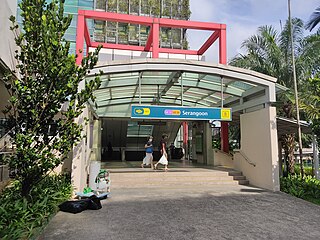
Serangoon MRT station is an underground Mass Rapid Transit (MRT) interchange station on the North East (NEL) and Circle (CCL) lines. Situated in Serangoon, Singapore along Upper Serangoon Road and Serangoon Central, the station is integrated with the Nex shopping complex and the Serangoon Bus Interchange. The station is near the Serangoon Neighbourhood Police Centre and Braddell Heights Community Hub and serves various residential estates in the area.

<span class="mw-page-title-main">MacPherson MRT station</span> Mass Rapid Transit station in Singapore

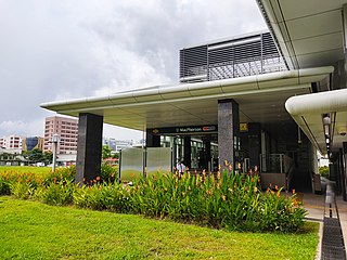
MacPherson MRT station is an underground Mass Rapid Transit (MRT) interchange station on the Downtown line and Circle line in Geylang planning area, Singapore, located underneath Paya Lebar Road at the junction with Circuit Link and Ubi Avenue 2.

<span class="mw-page-title-main">Promenade MRT station</span> Mass Rapid Transit station in Singapore

Promenade MRT station is an underground Mass Rapid Transit (MRT) interchange station on the Downtown (DTL) and Circle (CCL) lines in Downtown Core, Singapore. Located underneath Temasek Avenue and adjacent to Millenia Tower, the station serves several key attractions and locations such as Suntec City and the Marina Promenade, which the station is named after. The station is at the junction of the Dhoby Ghaut and Marina Bay branches of the CCL.

<span class="mw-page-title-main">Aljunied MRT station</span> Mass Rapid Transit station in Singapore

Aljunied MRT station is an above-ground Mass Rapid Transit (MRT) station on the East West line (EWL) in Geylang, Singapore. Named after Aljunied Road, this station primarily serves Aljunied, one of the subzones that make up Geylang planning area. On the EWL, it is between the Paya Lebar and Kallang stations.

<span class="mw-page-title-main">Nicoll Highway MRT station</span> Mass Rapid Transit station in Singapore

Nicoll Highway MRT station is an underground Mass Rapid Transit (MRT) station on the Circle Line (CCL) in Singapore. Located in the Downtown Core underneath Republic Avenue near the Kallang River, the station serves commercial and residential developments along Nicoll Highway, such as the Golden Mile Complex and The Concourse. The station is operated by SMRT Trains.

<span class="mw-page-title-main">Stadium MRT station</span> Mass Rapid Transit station in Singapore

Stadium MRT station is an underground Mass Rapid Transit (MRT) station on the Circle Line (CCL). Located in the area of Kallang, Central Region, Singapore, the station serves the Singapore Sports Hub and its facilities including the National Stadium, Indoor Stadium, Kallang Theatre and Leisure Park Kallang. It is operated by SMRT Trains.

<span class="mw-page-title-main">Bartley MRT station</span> Mass Rapid Transit station in Singapore

Bartley MRT station is an underground Mass Rapid Transit (MRT) station on the Stage 3 of the Circle line, located on the boundary of Serangoon and Toa Payoh planning areas, Singapore.

<span class="mw-page-title-main">Bras Basah MRT station</span> Mass Rapid Transit station in Singapore

Bras Basah MRT station is an underground Mass Rapid Transit (MRT) station on the Circle line (CCL) located in the Museum planning area, Singapore. It is underneath Bras Basah Road, bordering Waterloo Street and Queen Street. Located next to the Singapore Management University (SMU), this station is in proximity to the National Museum of Singapore, the Singapore Art Museum, Peranakan Museum and the Singapore School of the Arts. The station is connected to the nearby Bencoolen station on the Downtown line (DTL) via an unpaid link.

<span class="mw-page-title-main">Esplanade MRT station</span> Mass Rapid Transit station in Singapore

Esplanade MRT station is an underground Mass Rapid Transit (MRT) station on the Circle Line (CCL) in Singapore. Situated in the Downtown Core, it is at the junction of Bras Basah Road, Raffles Boulevard and Nicoll Highway. As the name suggests, the station serves the Esplanade performing arts centre, alongside various developments such as War Memorial Park, Suntec City Mall and the Suntec Singapore Convention and Exhibition Centre. Esplanade station is linked to the nearby City Hall station via CityLink Mall, an underground retail development.

<span class="mw-page-title-main">Haw Par Villa MRT station</span> Mass Rapid Transit station in Singapore

Haw Par Villa MRT station is an underground Mass Rapid Transit (MRT) station on the Circle line (CCL) in Queenstown, Singapore. Located underneath West Coast Highway and Pasir Panjang Road, the station serves the nearby Haw Par Villa, alongside the Pasir Panjang Wholesale Centre.

<span class="mw-page-title-main">Holland Village MRT station</span> Mass Rapid Transit station in Singapore

Holland Village MRT station is an underground Mass Rapid Transit (MRT) station on the Circle line (CCL), located along the boundary of Bukit Timah and Queenstown planning areas in Singapore. Situated close to the junction of Holland Avenue and Holland Road, it primarily serves the area of Holland Village, where its name was derived from. The station is operated by SMRT Trains.

<span class="mw-page-title-main">Gul Circle MRT station</span> Mass Rapid Transit station in Singapore

Gul Circle MRT station is an elevated Mass Rapid Transit (MRT) station on the East West line (EWL). Located in Tuas, western Singapore, the station serves the surrounding industries of JTC Space @ Tuas and Mapletree Pioneer Logistic Hub. The station is operated by SMRT Trains.

References

  1. Lye, Jaime (8 November 1985). "Lee Kim Tah wins MRT contract". The Business Times.
  2. "Add soul to the steel". The Straits Times. 4 November 1989. Retrieved 20 October 2017 via NewspaperSG.
  3. "MRT eastern line to start operating on Nov 18". The Business Times. 4 August 1989.
  4. "On right track". The Straits Times. 4 November 1989.
  5. Dhaliwal, Rav (5 November 1986). "MRT Trains to Pasir Ris from Dec 16". The Straits Times.
  6. "East-enders get ticket to ride as MRT opens line". The Straits Times. 4 November 1989.
  7. Wong, Siew Ying (26 January 2008). "Above-ground MRT stations to have platform screen doors by 2012". Channel NewsAsia. Archived from the original on 30 July 2012. Retrieved 1 February 2012.
  8. "Enhancing Connectivity and Comfort for Commuters". Land Transport Authority. 13 October 2011. Archived from the original on 25 December 2012. Retrieved 6 July 2012.
  9. "Railway Noise Barriers on Track". Archived from the original on 1 December 2017. Retrieved 22 November 2017.
  10. "Lum Chang - Civil & Infrastructure". www.lumchang.com.sg. Retrieved 17 August 2020.
  11. "CPG Consultants - Circle Line Stage 2 - Geotechnical and Structural Engineering Consultancy Services (Contract 823)". www.cpgcorp.com.sg. Retrieved 17 August 2020.
  12. "Projects - Rail". www.lta.gov.sg. 4 February 2009. Archived from the original on 19 September 2009.
  13. 1 2 3 "Lum Chang Technical Brochure" (PDF). www.lumchang.com.sg. Archived from the original (PDF) on 10 July 2021. Retrieved 19 August 2020.
  14. "Changes To Traffic Scheme And Bus Stop at the Paya Lebar MRT Station Vicinity". www.lta.gov.sg. Archived from the original on 23 April 2010.
  15. "Realignment of Sims Avenue And Paya Lebar Road". www.lta.gov.sg. Archived from the original on 23 April 2010.
  16. "ONE.MOTORING - Widening of Paya Lebar Road". www.onemotoring.com.sg. 19 August 2009. Archived from the original on 5 December 2009.
  17. 1 2 Cheong, Colin (2012). The Circle Line, Linking All Lines. Land Transport Authority. p. 61. ISBN   978-981-4342-02-5.
  18. "Transport minister announces next phase of Circle Line will open on 17 Apr". Channel NewsAsia. 26 January 2010. Archived from the original on 27 January 2010. Retrieved 26 January 2010.
  19. "Welcome Remarks By Mr Raymond Lim At The Opening Of The Circle Line From Dhoby Ghaut To Bartley on 16 April 2010". www.mot.gov.sg. Archived from the original on 1 May 2020. Retrieved 1 May 2020.
  20. "Circle Line from Bartley to Dhoby Ghaut to Open 17 April". www.lta.gov.sg. Archived from the original on 21 June 2011. Retrieved 26 January 2010.
  21. Chiang, Gracia (5 April 2007). "Man hits by train dies". The Straits Times.
  22. "SMRT Journeys". journey.smrt.com.sg. Retrieved 17 August 2020.
  23. "SMRT > Journey with Us > Trains > NetworkMap > PayaLebar". www.smrt.com.sg. Retrieved 17 August 2020.
  24. "Roof to make heads turn". The Straits Times. 20 April 1986.
  25. Cheong, Colin (2012). The Circle Line, Linking All Lines. Land Transport Authority. p. 159. ISBN   978-981-4342-02-5.
  26. Cheong, Colin (2012). The Circle Line, Linking All Lines. Land Transport Authority. p. 149. ISBN   978-981-4342-02-5.
  27. "Fun Fact Friday: Middle Track at Paya Lebar MRT Station". SGTrains. 25 September 2020. Retrieved 22 December 2023.
  28. "Getting Around - Public Transport - A Better Public Transport Experience - Art in Transit". LTA. 25 June 2020. Archived from the original on 21 April 2020. Retrieved 18 August 2020.
  29. "Circle Line Art" (PDF). www.lta.gov.sg. Archived from the original (PDF) on 11 February 2017.
  30. "Singapore Built & Unbuilt". www.mci.gov.sg/. Retrieved 18 August 2020.
  31. Zhuang, Justin (2013). Art in transit : circle line MRT-Singapore. Soh, Darren, Singapore. Land Transport Authority. Singapore. ISBN   978-981-07-4982-8. OCLC   854958677.{{cite book}}: CS1 maint: location missing publisher (link)
  32. "Getting to Paya Lebar Quarter". Paya Lebar Quarter. Retrieved 30 November 2020.