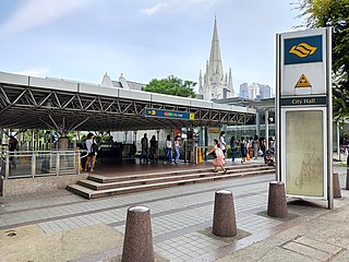
City Hall MRT station is an underground Singapore Mass Rapid Transit (MRT) interchange station on the North–South line (NSL) and East–West line (EWL). Situated in the Downtown Core district, it is underneath Stamford Road near the road junctions with North Bridge Road and St Andrew's Road. The station is near landmarks such as the former City Hall, Raffles City, the Padang, St Andrew's Cathedral and the Cenotaph.

Dhoby Ghaut MRT station is an underground Mass Rapid Transit (MRT) interchange station on the North South, North East and Circle lines in Singapore. Located beneath the eastern end of Orchard Road shopping belt in Dhoby Ghaut, Museum Planning Area, the station is integrated with the commercial development The Atrium@Orchard. The station is near landmarks such as The Istana, the MacDonald House, Plaza Singapura and Dhoby Ghaut Green.

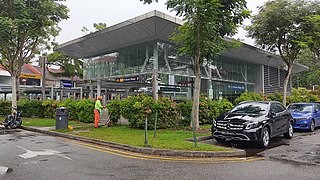
Buona Vista MRT station is a Mass Rapid Transit (MRT) interchange station on the East West line and Circle line in Queenstown, Singapore. This station is close to one-north, a high technology business park for the biomedical science, infocomm technology and media industries. It is located near the junction of North Buona Vista Road, Commonwealth Avenue and Commonwealth Avenue West.

Marina Bay MRT station is an underground Mass Rapid Transit (MRT) interchange station on the North South (NSL), Circle (CCL) and Thomson–East Coast (TEL) lines in Singapore. Located in the Downtown Core district near Marina Bay, the station serves the Marina One Residences, Marina Bay Suites and the Marina Bay Financial Centre.

Chinatown MRT station is an underground Mass Rapid Transit (MRT) interchange station on the North East (NEL) and Downtown (DTL) lines in Outram, Singapore. It serves the ethnic enclave of Chinatown. Situated at the junction of Eu Tong Sen Street, New Bridge Road and Upper Cross Street, the station is near several landmarks, including the Buddha Tooth Relic Temple, Masjid Jamae (Chulia), Chinatown Point and People's Park Complex.
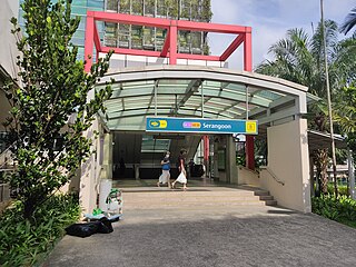
Serangoon MRT station is an underground Mass Rapid Transit (MRT) interchange station on the North East (NEL) and Circle (CCL) lines. Situated in Serangoon, Singapore along Upper Serangoon Road and Serangoon Central, the station is integrated with the Nex shopping complex and the Serangoon Bus Interchange. The station is near the Serangoon Neighbourhood Police Centre and Braddell Heights Community Hub and serves various residential estates in the area.

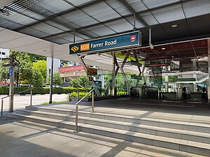
Farrer Park MRT station is an underground Mass Rapid Transit (MRT) station along the North East line, located on the boundary of Kallang and Rochor planning areas, Singapore. It is one of the two stations that serve the ethnic district of Little India. The station sits underneath the Connexion building, an integrated hospital and hotel complex.

Botanic Gardens MRT station is an underground Mass Rapid Transit (MRT) interchange station on the Circle line (CCL) and the Downtown line (DTL). Situated in Tanglin, Singapore, the station is located northwest of the Singapore Botanic Gardens at the junction of Bukit Timah Road and Cluny Park Road. Other nearby developments of the station include Crown Centre, Serene Centre, Cluny Court, Adam Road Food Centre and the National University of Singapore Faculty of Law.

Mountbatten MRT station is an underground Mass Rapid Transit (MRT) station on the Circle line, located on the boundary of Kallang, Geylang and Marine Parade, Singapore.

Dakota MRT station is an underground Mass Rapid Transit (MRT) station on the Circle line in Geylang planning area, Singapore, next to Geylang River.

Bras Basah MRT station is an underground Mass Rapid Transit (MRT) station on the Circle line (CCL) located in the Museum planning area, Singapore. It is underneath Bras Basah Road, bordering Waterloo Street and Queen Street. Located next to the Singapore Management University (SMU), this station is in proximity to the National Museum of Singapore, the Singapore Art Museum, Peranakan Museum and the Singapore School of the Arts. The station is connected to the nearby Bencoolen station on the Downtown line (DTL) via an unpaid link.

Esplanade MRT station is an underground Mass Rapid Transit (MRT) station on the Circle Line (CCL) in Singapore. Situated in the Downtown Core, it is at the junction of Bras Basah Road, Raffles Boulevard and Nicoll Highway. As the name suggests, the station serves the Esplanade performing arts centre, alongside various developments such as War Memorial Park, Suntec City Mall and the Suntec Singapore Convention and Exhibition Centre. Esplanade station is linked to the nearby City Hall station via CityLink Mall, an underground retail development.
one-north MRT station is an underground Mass Rapid Transit (MRT) station on the Circle line in Queenstown, Singapore.

Haw Par Villa MRT station is an underground Mass Rapid Transit (MRT) station on the Circle line (CCL) in Queenstown, Singapore. Located underneath West Coast Highway and Pasir Panjang Road, the station serves the nearby Haw Par Villa, alongside the Pasir Panjang Wholesale Centre.

Kent Ridge MRT station is an underground Mass Rapid Transit (MRT) station on the Circle Line (CCL). Located in the eponymous Kent Ridge of Queenstown, Singapore, the station is near the junction of South Buona Vista Road and Lower Kent Ridge Road. The station serves the National University Hospital and the National University of Singapore.

Labrador Park MRT station is an underground Mass Rapid Transit (MRT) station on the Circle line, located within Bukit Merah planning area, Singapore.
Holland Village MRT station is an underground Mass Rapid Transit (MRT) station on the Circle line (CCL), located along the boundary of Bukit Timah and Queenstown planning areas in Singapore. Situated close to the junction of Holland Avenue and Holland Road, it primarily serves the area of Holland Village, where its name was derived from. The station is operated by SMRT Trains.

Caldecott MRT station is an underground Mass Rapid Transit (MRT) interchange station on the Circle line (CCL) and Thomson–East Coast line (TEL), located in Toa Payoh planning area, Singapore. It is situated underneath Toa Payoh Link near the junction of Toa Payoh Rise, located near the Singapore Association of the Visually Handicapped (SAVH), the Caldecott Broadcast Centre and Mount Alvernia Hospital. The station is operated by SMRT Trains.

Sixth Avenue MRT station is an underground Mass Rapid Transit (MRT) station on the Downtown line in Bukit Timah, Singapore.

King Albert Park MRT station is an underground Mass Rapid Transit (MRT) station on the Downtown Line (DTL) in Bukit Timah, Singapore. Located at the western end of Bukit Timah Road at the junction of Blackmore Drive, this station serves the private residential estates along the Bukit Timah corridor. Sites surrounding the station include Methodist Girls' School, Ngee Ann Polytechnic, and the preserved Bukit Timah Railway Station.