Holland Village MRT station

Last updated

 CC21 
Holland Village
荷兰村
ஹாலந்து வில்லேஜ்
Mass Rapid Transit (MRT) station
CC21 Holland Village MRT Exit A 20201126 130720.jpg
Exit A of the station
General information
Location200 Holland Avenue
Singapore 278995 [1]
Coordinates 1°18′43″N103°47′46″E / 1.312078°N 103.796208°E / 1.312078; 103.796208
Operated by SMRT Trains Ltd (SMRT Corporation)
Line(s)
Platforms2 (1 island platform)
Tracks2
ConnectionsBus, Taxi
Construction
Structure typeUnderground
Platform levels1
AccessibleYes
History
Opened8 October 2011;11 years ago (2011-10-08)
ElectrifiedYes
Previous namesHolland, Chip Bee [2]
Services
Preceding station Mass Rapid Transit Following station
Farrer Road Circle Line Buona Vista
towards HarbourFront
Location
SGMRT-LRT (zoom) map.svg
Red Dot.svg
Holland Village
Location of Holland Village station in Singapore

Holland Village MRT station is an underground Mass Rapid Transit (MRT) station on the Circle line (CCL), located along the boundary of Bukit Timah and Queenstown planning areas in Singapore. Situated close to the junction of Holland Avenue and Holland Road, it primarily serves the area of Holland Village, where its name was derived from. The station is operated by SMRT Trains.

Contents

First announced as Holland MRT station in 2003, the station was renamed Holland Village through a public poll in 2005. The station opened on 8 October 2011 when Stages 4 and 5 of the CCL stations opened. The station features Holland Beat by Jeremy Sharma as part of the MRT network's Art-in-Transit programme.

History

The entrance to the station under construction Holland Village MRT Station, Singapore, under construction - 20101118.jpg
The entrance to the station under construction

The station was first announced as Holland station when the Circle Line (CCL) Stages 4 and 5 stations were revealed in 2003. [3] [4] The contract for the construction of Holland station was awarded to Woh Hup (Pte) Ltd–Shanghai Tunnel Engineering Co. Ltd–Alpine Mayreder bau GmbH (WH-STEC-AM) Joint Venture at a contract value of S$ 399.91 million ( US$ 236.6 million) in 2004. [5] [6] The construction of the 8.25-kilometre (5.13 mi) bored tunnels required the use of 6.35-metre (20.8 ft) diameter Earth pressure balance (EPB) machines. [5] In 2005, the station name was finalised as Holland Village. [2] [7]

Careful excavation was needed during the station construction, due to the close proximity of residential properties around the station. The construction walls were closely monitored to detect any deflection and soil settlement. Residents and shophouses were also kept informed during the station's construction. [8] The station opened on 8 October 2011 as part of the CCL extension to HarbourFront station. [9] [10] [11]

On 29 July 2018, as part of a joint emergency preparedness exercise by the Land Transport Authority (LTA) and train operator SMRT, security screenings were conducted at the station. [12] This is the second emergency preparedness exercise conducted at a public transport node in 2018, after Newton station. Such exercises were to test established response protocols and maintain vigilance for quicker and effective responses in the case of an incident. [13]

Station details

Name and location

Holland Village station is named after the nearby Holland Road, which in turn it was named after an early resident, Hugh Holland, a well-respected architect. [14] During a naming poll by the Land Transport Authority (LTA), "Holland Village" garnered the most votes with 87.1%, compared to the alternative proposed name "Chip Bee" at 7.1%. [2]

The station is located underneath Holland Road, with its entrances situated along Holland Avenue. [15] [16] The station serves Holland Village and nearby landmarks such as the Holland Village Market and Food Centre, Anglo-Chinese School (International), Masjid Kampong Holland and the Vietnamese Embassy. [15]

Services

The station serves the Circle line (CCL) and is situated between the Farrer Road and Buona Vista stations. The station code is CC21 on official maps. [17] The station operates daily between 5:37 am and 12:21 am. [18] Train frequencies vary from 2 to 5 minutes depending on peak hours. [19]

Design

Designed by SAA Architects, Holland Village station adopts a minimalist concept using several pre-fabricated constituents. The entrance, intended to be distinguishable in the streetscape, employs a lightweight structure with glass materials on its exterior to allow the visibility of the shophouses at the ground level. [20]

Within the station's interior, there are retail shops at the concourse level as part of the SMRT Shop & Dine Concept, [21] to provide a retail experience for commuters. The station has a simple layout to facilitate ease of movement, fulfilling the operational criteria for the station. The artwork and the distinguishing features of the station help foster an identity for Holland Village station. [20]

Station artwork

Art-in-Transit artwork on the lift shaft of the station CC21 Holland Village MRT platforms 20201126 131020.jpg
Art-in-Transit artwork on the lift shaft of the station

Commissioned as part of the MRT network's Art-in-Transit Programme, [lower-alpha 1] Holland Beat by Jeremy Sharma is displayed on the lift shaft of the station. The artwork depicts drawings and images of Holland Village in a style reminiscent of American pop art. [22] The title of the artwork "Holland Beat", as the artist explained, refers to the "tempo and rhythm" of the neighbourhood. [23]

Seeking inspiration for his work, the artist spent an afternoon at Holland Village, capturing images that caught his attention. These pictures were then turned into drawings, generating up to 50 sketches of Holland Village's objects, scenes, signs and architectural features. Using digital means, these images were combined into a collage, superposed on an image of an airline safety card, which design and colours the artist was fascinated by. [23] [24] This produced a set of drawings in a style similar to Roy Lichtenstein, an American pop artist. Adding texture and intrigue to the artworks, some of the pencil markings were removed, creating vibrant everyday scenes "injecting street life" to the otherwise "dull" station design. [25]

Using a vertical canvas, Sharma eventually chose eight drawings which were then arranged in a non-linear fashion, leaving enough negative space to avoid the work "resembling a newspaper". When the drawings were scanned and expanded on the larger 8.8-metre (29 ft) by 2.8-metre (9.2 ft) canvas, the images came out pixellated since the drawings were initially small. Using digital software, the artist then converted the drawings into a mosaic made up of distinct colour blobs. [25] This resulted in the work resembling an impressionist painting made up of very visible brush strokes, allowing the work to be viewed from afar and its details appreciated up close. When shown the two versions (the colour blobs vs the pixellated version), the LTA architects and the artist agreed on the former as they felt this had a "much strong concept". This work reflects the artist's artistic vision of works that "blur the sources" the painting was derived from, with the integration of elements from paintings, digital drawing and photography, which also reflects the artists' career. The title was also seen as a reference to Sharma's background as a former guitarist and songwriter. [26]

Notes and references

Notes

  1. Public art showcase which integrates artworks into the MRT network

Related Research Articles

<span class="mw-page-title-main">Circle MRT line</span> Mass Rapid Transit line in Singapore

The Circle Line (CCL) is a medium-capacity Mass Rapid Transit line in Singapore operated by SMRT Corporation. It runs in a currently incomplete loop from Dhoby Ghaut station in the city area of Singapore to HarbourFront station in the south via Bishan station in Central Singapore. It also has a branch to Marina Bay station from Promenade station, which will be extended to Harbourfront station from 2026 to form a complete loop. Coloured orange on the rail map, the fully-underground line is 35.5 kilometres (22.1 mi) long with 30 stations. Travelling from one end of the line to the other takes about an hour.

<span class="mw-page-title-main">Dhoby Ghaut MRT station</span> Mass Rapid Transit station in Singapore

Dhoby Ghaut MRT station is an underground Mass Rapid Transit (MRT) interchange station on the North South, North East and Circle lines in Singapore. Located beneath the eastern end of Orchard Road shopping belt in Dhoby Ghaut, Museum Planning Area, the station is integrated with the commercial development The Atrium@Orchard. The station is near landmarks such as The Istana, the MacDonald House, Plaza Singapura and Dhoby Ghaut Green.

<span class="mw-page-title-main">HarbourFront MRT station</span> Mass Rapid Transit station in Singapore

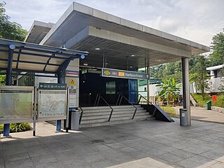
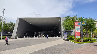
HarbourFront MRT station is an underground Mass Rapid Transit (MRT) interchange station in Singapore. The termini of the North East line (NEL) and Circle line (CCL), the station serves the HarbourFront area and Sentosa. Surrounding retail and commercial developments include VivoCity and HarbourFront Centre, and the station is near HarbourFront Bus Interchange and the Singapore Cruise Centre.

<span class="mw-page-title-main">Paya Lebar MRT station</span> Mass Rapid Transit station in Singapore

Paya Lebar MRT station is a Mass Rapid Transit (MRT) interchange station on the East West line (EWL) and Circle line (CCL) in Geylang, Singapore. Despite the name, this station is not located in Paya Lebar but rather along Paya Lebar Road, near the junction with Sims Avenue. It is located among the developments of the Paya Lebar Central commercial hub and near the Geylang Serai district.

<span class="mw-page-title-main">Bishan MRT station</span> Mass Rapid Transit station in Singapore

Bishan MRT station is a Mass Rapid Transit (MRT) interchange station on the North–South (NSL) and Circle (CCL) lines in Bishan, Singapore. The station is located along Bishan Road within the town centre; it is integrated with Junction 8 shopping centre and is close to Bishan Bus Interchange. Nearby schools include Raffles Institution, Catholic High School, and Kuo Chuan Presbyterian Primary and Secondary Schools.

<span class="mw-page-title-main">Marina Bay MRT station</span> Mass Rapid Transit station in Singapore

Marina Bay MRT station is an underground Mass Rapid Transit (MRT) interchange station on the North South (NSL), Circle (CCL) and Thomson–East Coast (TEL) lines in Singapore. Located in the Downtown Core district near Marina Bay, the station serves the Marina One Residences, Marina Bay Suites and the Marina Bay Financial Centre.

<span class="mw-page-title-main">Serangoon MRT station</span> Mass Rapid Transit station in Singapore

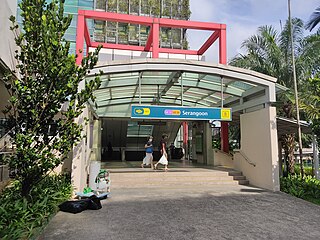
Serangoon MRT station is an underground Mass Rapid Transit (MRT) interchange station on the North East (NEL) and Circle (CCL) lines. Situated in Serangoon, Singapore along Upper Serangoon Road and Serangoon Central, the station is integrated with the Nex shopping complex and the Serangoon Bus Interchange. The station is near the Serangoon Neighbourhood Police Centre and Braddell Heights Community Hub and serves various residential estates in the area.
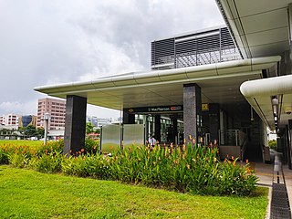
<span class="mw-page-title-main">Botanic Gardens MRT station</span> Mass Rapid Transit station in Singapore

Botanic Gardens MRT station is an underground Mass Rapid Transit (MRT) interchange station on the Downtown line and Circle line in Tanglin, Singapore, located at the junction of Bukit Timah Road and Cluny Park Road.

<span class="mw-page-title-main">Promenade MRT station</span> Mass Rapid Transit station in Singapore

Promenade MRT station is an underground Mass Rapid Transit (MRT) interchange station on the Downtown (DTL) and Circle (CCL) lines in Downtown Core, Singapore. Located underneath Temasek Avenue and adjacent to Millenia Tower, the station is close to several key attractions and locations such as Suntec City and the Marina Promenade, which the station is named after. The station is at the junction of the Dhoby Ghaut and Marina Bay branches of the CCL.

<span class="mw-page-title-main">Stadium MRT station</span> Mass Rapid Transit station in Singapore

<span class="mw-page-title-main">Bartley MRT station</span> Mass Rapid Transit station in Singapore

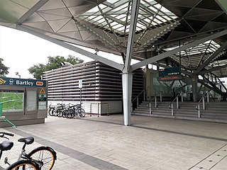
Bartley MRT station is an underground Mass Rapid Transit (MRT) station on the Stage 3 of the Circle line, located on the boundary of Serangoon and Toa Payoh planning areas, Singapore.

<span class="mw-page-title-main">Bras Basah MRT station</span> Mass Rapid Transit station in Singapore

Bras Basah MRT station is an underground Mass Rapid Transit (MRT) station on the Circle line (CCL) located in the Museum planning area, Singapore. It is underneath Bras Basah Road, bordering Waterloo Street and Queen Street. Located next to the Singapore Management University (SMU), this station is in proximity to the National Museum of Singapore, the Singapore Art Museum, Peranakan Museum and the Singapore School of the Arts. The station is connected to the nearby Bencoolen station on the Downtown line (DTL) via an unpaid link.

<span class="mw-page-title-main">Esplanade MRT station</span> Mass Rapid Transit station in Singapore

Esplanade MRT station is an underground Mass Rapid Transit (MRT) station on the Circle line (CCL) in Singapore. Situated in the Downtown Core, it is at the junction of Bras Basah Road, Raffles Boulevard and Nicoll Highway. As the name suggests, the station serves the Esplanade performing arts centre, alongside various developments such as War Memorial Park, Suntec City Mall and the Suntec Singapore Convention and Exhibition Centre. Esplanade station is linked to the nearby City Hall station via CityLink Mall, an underground retail development.

<span class="mw-page-title-main">Bayfront MRT station</span> Mass Rapid Transit station in Singapore

Bayfront MRT station is an underground Mass Rapid Transit (MRT) interchange station on the Downtown line (DTL) and Circle line (CCL). Located in the Downtown Core of Singapore, the station is underneath Bayfront Avenue and serves the main tourist attractions of Marina Bay Sands and Gardens by the Bay.

<span class="mw-page-title-main">Haw Par Villa MRT station</span> Mass Rapid Transit station in Singapore

Haw Par Villa MRT station is an underground Mass Rapid Transit (MRT) station on the Circle line (CCL) in Queenstown, Singapore. Located underneath West Coast Highway and Pasir Panjang Road, the station serves the nearby Haw Par Villa, alongside the Pasir Panjang Wholesale Centre.

<span class="mw-page-title-main">Caldecott MRT station</span> Mass Rapid Transit station in Singapore

| mapframe = | mpassengers = | map_type = Singapore Rail central area | map_caption = Caldecott station in Singapore | map_dot_label = Caldecott | map_alt = Singapore MRT/LRT system map | map_size = 300px | map_state = collapsed }}

<span class="mw-page-title-main">SMRT Trains</span> Singapore train operator

SMRT Trains Limited is a rail operator in Singapore and a wholly owned subsidiary of SMRT Corporation. After the privatisation of the MRT operations in 1995, it was originally named Singapore MRT Limited. On 31 December 2001, it was renamed to SMRT Trains Limited, so as not to confuse with another MRT line - North East MRT Line that is under Singapore Bus Services and the bus operations merged from Trans-Island Bus Services. At the same time, Singapore Bus Services was renamed to SBS Transit to be multi-modal. SMRT Trains currently manages most of the MRT services in Singapore except the North East Line and Downtown Line.

<span class="mw-page-title-main">Stevens MRT station</span> Mass Rapid Transit station in Singapore

Stevens MRT station is an underground Mass Rapid Transit (MRT) interchange station on the Downtown (DTL) and Thomson–East Coast (TEL) lines. Situated at the junction of Stevens Road and Bukit Timah Road, it serves the nearby Singapore Chinese Girls' School and St. Joseph's Institution, as well as the Raffles Town Club and the surrounding private estates.

<span class="mw-page-title-main">Keppel MRT station</span> Mass Rapid Transit station in Singapore

Keppel MRT station is a future underground Mass Rapid Transit (MRT) station on the Circle line, located in Bukit Merah planning area, Singapore. This station is part of Stage 6 of the Circle line (CCL6) which will "close the circle" between the HarbourFront and Marina Bay stations. The station will be located along Keppel Road, near to the Keppel Harbour. Slated for completion by 2026, Keppel station will serve the upcoming Greater Southern Waterfront.

References

  1. "Holland Village (MRT Station) - 200 Holland Avenue (S)278995". streetdirectory.com. 26 November 2020. Archived from the original on 3 August 2018. Retrieved 26 November 2020.
  2. 1 2 3 "Finalised Names for Circle Line (CCL) Stages 4&5 Stations". www.lta.gov.sg. Archived from the original on 25 November 2005.
  3. "Completing the Circle via Holland V". Today. 13 December 2003. Archived from the original on 6 March 2020. Retrieved 26 November 2020.
  4. "Stages 4 & 5 of Circle Line". www.lta.gov.sg. 16 November 2005. Archived from the original on 19 December 2011. Retrieved 21 September 2020.
  5. 1 2 "Singapore LTA CCL4 C855". www.stecs.com. Archived from the original on 26 November 2020. Retrieved 26 November 2020.
  6. "Award of Contract for Construction And Completion of Holland, Buona Vista And NUH Stations". www.lta.gov.sg. Archived from the original on 14 January 2012. Retrieved 26 November 2020.
  7. "Station Names For Circle Line Stages 4 And 5". www.lta.gov.sg. 7 November 2005. Archived from the original on 23 April 2010.
  8. Cheong, Colin (2012). The Circle Line : Linking all lines. Singapore: Published for the Land Transport Authority by Straits Times Press. p. 77. ISBN   978-981-4342-02-5. OCLC   743194452.
  9. "Connect - October 2011" (PDF). www.lta.gov.sg. Archived from the original (PDF) on 5 February 2018.
  10. "Speech by Mr Tharman Shanmugaratnam at the Circle Line Opening Ceremony on 7 Oct 2011". www.mot.gov.sg. Archived from the original on 1 May 2020. Retrieved 1 May 2020.
  11. "MOT Singapore – Gain new perspectives on land, sea & air transport". www.mot.gov.sg. Archived from the original on 19 November 2020. Retrieved 28 April 2020.
  12. Zhuo, Tee (17 July 2018). "X-ray scanner, screening detector to be used at Holland Village MRT for SMRT-LTA exercise". The Straits Times. Archived from the original on 26 November 2020. Retrieved 26 November 2020.
  13. "News Room - News Releases - Joint News Release by the Land Transport Authority (LTA) & SMRT - Emergency Preparedness Exercise for Heightened Security Threats". www.lta.gov.sg. 17 July 2018. Archived from the original on 26 November 2020. Retrieved 26 November 2020.
  14. "Holland Village". Visit Singapore Official Site. Archived from the original on 28 November 2020. Retrieved 28 November 2020.
  15. 1 2 "SMRT > Journey with Us > Trains > NetworkMap > HollandVillage". SMRT Corporation Ltd. 4 February 2015. Archived from the original on 26 November 2020. Retrieved 28 November 2020.
  16. "Holland Village MRT Station". Google Maps. Archived from the original on 28 November 2020. Retrieved 28 November 2020.
  17. "MRT System Map" (PDF). Land Transport Authority (LTA). Archived (PDF) from the original on 21 August 2020. Retrieved 23 August 2020.
  18. "SMRT Journeys". SMRT Journeys. Archived from the original on 28 November 2020. Retrieved 28 November 2020.
  19. "Transport Tools - MRT/LRT". www.lta.gov.sg. 6 May 2020. Archived from the original on 1 November 2019. Retrieved 19 June 2020.
  20. 1 2 "Circle Line Holland Village MRT Station CC21". SAA Group Architects. 26 October 2018. Archived from the original on 26 October 2018. Retrieved 9 January 2021.
  21. "SMRT Shops > Locate a Store > Circle Line". SMRT Shops. 4 February 2015. Retrieved 9 January 2021.
  22. "Getting Around - Public Transport - A Better Public Transport Experience - Art in Transit". www.lta.gov.sg. 7 April 2020. Archived from the original on 21 April 2020. Retrieved 21 April 2020.
  23. 1 2 Zhuang 2013, p. 126.
  24. Martin, Mayo. "Circle Line Art! The final destination(s)! A sneak peek!". For Art's Sake!. TODAYonline Blogs. Archived from the original on 27 December 2011. Retrieved 11 October 2011.
  25. 1 2 Zhuang 2013, p. 128.
  26. Zhuang 2013, p. 129.

Works cited