Telok Ayer Street

Last updated

Telok Ayer
Name transcription(s)
   Chinese 直落亚逸
   Pinyin zhíluòyǎyì
   Malay Telok Ayer
   Tamil தேலோக் ஆயர்
Telok Ayer Street, Dec 05.JPG
Telok Ayer Street, one of the earliest thoroughfares in downtown Singapore.
Country Singapore
Planning area Outram

Telok Ayer Street is a street located in Singapore's Chinatown within the Outram district, linking Church Street to Cecil Street. Telok Ayer MRT station is located at the junction of Cross Street and this road.

Contents

Etymology

Telok Ayer Street was originally a coastal road along the Telok Ayer Bay and was named after the bay. [1]

On George Drumgoole Coleman's 1836 Map of Singapore, it was known as Teluk Ayer Street. [1]

The Chinese name for the street is da bo gong miao jie which refers to the Fuk Tak Chi Temple located on Telok Ayer street. It was also known colloquially under two other names; The area near Merchant Street was called Guan Soon Street due to a firm, Chop Guan Soon, located there that brought in Indian labourers, The other is in Hokkien, meaning the "front street" of Thian Hock Keng which is dedicated to Goddess of the Sea, Mah Cho or Matsu. [1]

History

Telok Ayer Street, Chinatown Telok Ayer Street, 2010.jpg
Telok Ayer Street, Chinatown
Telok Ayer Green, a small park with sculptures depicting the festival activities of early Chinese immigrants in Singapore. Chinese Procession (2001) by Lim Leong Seng, Telok Ayer Green, Singapore - 20051231.jpg
Telok Ayer Green, a small park with sculptures depicting the festival activities of early Chinese immigrants in Singapore.

In 1822, Telok Ayer Street was the primary area set aside by Sir Stamford Raffles for the Chinese community. As the main landing site for Chinese immigrants, Telok Ayer Street become one of the first streets in Chinatown and formed the backbone of development of the Chinese immigrant community in early Singapore. Thus, Telok Ayer Street was the original focal point of settlement in Chinatown.

Until the late nineteenth century, Telok Ayer Street was the main commercial and residential thoroughfare in Singapore. As immigration from China increased, so did the adverse qualities usually associated with a highly concentrated population. The high trade traffic along the road leads to the road being the center of the early Chinese slave trade in Singapore. [1]

Before land reclamation was done in the area, boats used to moor in Telok Ayer Bay waiting to get fresh water, carried by bullock carts, from a well at Ann Siang Hill. [1]

In 1863, a group of local businessmen including Whampoa, went to Governor Orfeur Cavenagh to request reclaim land in the bay by building a pier and a seawall and filling in the bay at their own expenses to build warehouses. [2] However, the request was rejected at that time. [1] In 1865, plans for reclamation were again put forward and reclamation work was carried out between 1878 and 1885. [1] The land reclamation works including draining the existing marshland, removing the nutmeg plantations, and Telok Ayer Bay was filled in with land removed from hills along the coast, including Mount Wallich. [1] [2] Maritime buildings were then built on the reclaimed land. Thian Hock Keng which was previously sea facing was five blocks away from the sea front.

Robinson Road and Anson Road were subsequently built in the reclaimed area.

The street also was the founding site of one of Singapore's oldest schools, Gan Eng Seng School, which was started in 1885 at 106 Telok Ayer Street as the Anglo-Chinese Free School. The historical site marker of the school is nearby at the junction of Telok Ayer and Cecil Streets.

Temples and mosques are plentiful in this area as they were built by Chinese and Indian Muslim immigrants to show their gratitude for safe passage. The numerous religious and clan buildings on Telok Ayer Street testify to their importance in the past. These buildings include:

Thian Hock Keng, the oldest Hokkien temple in Singapore. Thian Hock Keng Temple 3, Dec 05.JPG
Thian Hock Keng, the oldest Hokkien temple in Singapore.

Conservation and architecture

Telok Ayer Street has been gazetted under the government's conservation plan. When the conservation project was completed, some of the area's shophouses were restored to their original appearance. Many of these shophouses are two- and three-storey, mostly the result of the land division of the time which consisted of deep sites with narrow frontages. The frontages are based on the then available length of timber beams, usually 16 feet (about 4.8 metres).

Related Research Articles

<span class="mw-page-title-main">Chinatowns in Asia</span>

Chinatowns in Asia are widespread with a large concentration of overseas Chinese in East Asia and Southeast Asia and ethnic Chinese whose ancestors came from southern China—particularly the provinces of Guangdong, Fujian, and Hainan—and settled in countries such as Brunei, Cambodia, East Timor, Indonesia, India, Laos, Malaysia, Myanmar, the Philippines, Singapore, Sri Lanka, Thailand, Vietnam, Japan and Korea centuries ago—starting as early as the Tang dynasty, but mostly notably in the 17th through the 19th centuries, and well into the 20th century. Today the Chinese diaspora in Asia is primarily concentrated in Southeast Asia; however, the legacy of the once widespread overseas Chinese communities in Asia is evident in the many Chinatowns found across East, South and Southeast Asia.

<span class="mw-page-title-main">Chinatown, Singapore</span> Neighborhood in Singapore, subzone of Outram

Chinatown is a subzone and ethnic enclave located within the Outram district in the Central Area of Singapore. Featuring distinctly Chinese cultural elements, Chinatown has had a historically concentrated ethnic Chinese population.

<span class="mw-page-title-main">Tan Tock Seng</span> Singaporean merchant and philanthropist

Tan Tock Seng was a Malacca-born merchant and philanthropist from Singapore.

<span class="mw-page-title-main">Chinese Singaporeans</span> Ethnic group

Chinese Singaporeans are Singaporeans of Han Chinese descent. Chinese Singaporeans constitute 75.9% of the Singaporean citizen population according to the official census, making them the largest ethnic group in Singapore.

<span class="mw-page-title-main">Sri Mariamman Temple, Singapore</span> Hindu temple in Singapore

The Sri Mariamman Temple is Singapore's oldest Hindu temple. It is an agamic temple, built in the Dravidian style. Located at 244 South Bridge Road, in the downtown Chinatown district, the temple serves the majority Hindu Singaporeans, Tamilians, in the city-state. Due to its architectural and historical significance, the temple has been gazetted a National Monument and is a major tourist attraction. Sri Mariamman Temple is managed by the Hindu Endowments Board, a statutory board under the Ministry of Community Development, Youth and Sports.

<span class="mw-page-title-main">Tanjong Pagar</span> Historic district in Singapore

Tanjong Pagar is a historic district located within the Central Business District of Singapore, straddling the Outram Planning Area and the Downtown Core under the Urban Redevelopment Authority's urban planning zones. The district has a rich history and is known for its cultural and architectural landmarks, making it a popular tourist destination.

<span class="mw-page-title-main">Thian Hock Keng</span> Mazu temple in Singapore

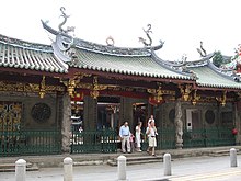
Thian Hock Keng, is a temple built for the worship of Mazu, a Chinese sea goddess, located in Singapore. It is the oldest and most important temple of the Hokkien (Hoklo) people in the country. Another shrine at the back is Buddhist dedicated to Guanyin, the Mahayana Buddhist bodhisattva of mercy.

<span class="mw-page-title-main">Central Area, Singapore</span> City centre in Central Region, Singapore

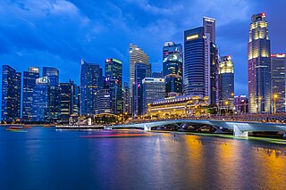
The Central Area, also called the City Area, and informally The City, is the main commercial city centre of Singapore. Located in the south-eastern part of the Central Region, the Central Area consists of eleven constituent planning areas: the Downtown Core, Marina East, Marina South, the Museum Planning Area, Newton, Orchard, Outram, River Valley, Rochor, the Singapore River and Straits View, as defined by the Urban Redevelopment Authority. The term Central Business District (CBD) has also been used to describe most of the Central Area as well, although its boundaries lie within the Downtown Core.

<span class="mw-page-title-main">Jackson Plan</span> 1822 urban plan for Singapore

The Jackson Plan or Raffles Town Plan, an urban plan of 1822 titled "Plan of the Town of Singapore", is a proposed scheme for Singapore drawn up to maintain some order in the urban development of the fledgling but thriving colony founded just three years earlier. It was named after Lieutenant Philip Jackson, the colony's engineer and land surveyor tasked to oversee its physical development in accordance with the vision of Stamford Raffles for Singapore, hence it is also commonly called Raffles Town Plan. Raffles gave his instructions in November 1822, the plan was then drawn up in late 1822 or early 1823 and published in 1828. It is the earliest extant plan for the town of Singapore, but not an actual street map of Singapore as it existed in 1822 or 1827 since the plan is an idealised scheme of how Singapore may be organised that was not fully realised. Nevertheless, it served as a guide for the development of Singapore in its early days, and the effect of the general layout of the plan is still observable to this day.

<span class="mw-page-title-main">Telok Ayer MRT station</span> Mass Rapid Transit station in Singapore

Telok Ayer MRT station is an underground Mass Rapid Transit (MRT) station on the Downtown line (DTL). Situated in Outram, Singapore, the station serves various offices and commercial developments around the junction of Cross Street and Telok Ayer Street. The station is operated by SBS Transit.

<span class="mw-page-title-main">Boon Tat Street</span>

Boon Tat Street is in the Downtown Core in the Central Area of Singapore. The street extends from Amoy Street at its western end to the junction of Shenton Way and Raffles Quay.

<span class="mw-page-title-main">Lau Pa Sat</span> Historic building in Singapore used as a food centre

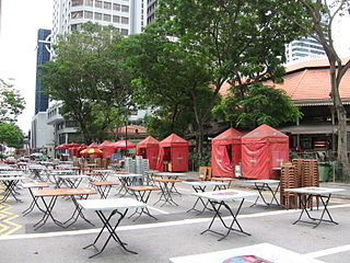
Lau Pa Sat, also known as Telok Ayer Market, is a historic building located within the Downtown Core in the Central Area of Singapore. It was first built in 1824 as a fish market on the waterfront serving the people of early colonial Singapore and rebuilt in 1838. It was then relocated and rebuilt at the present location in 1894. It is currently a food court with stalls selling a variety of local cuisine.

<span class="mw-page-title-main">Telok Ayer Chinese Methodist Church</span> Church in Singapore

Telok Ayer Chinese Methodist Church, is located on Telok Ayer Street within the Downtown Core of Singapore's central business district. The church is approximately 450 metres from Telok Ayer MRT station.

<span class="mw-page-title-main">Amoy Street, Singapore</span> Street in Singapore

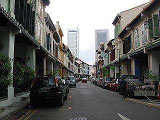
Amoy Street is a one-way street located within Chinatown, within the Outram district in Singapore. The street is close to Tanjong Pagar MRT station.

<span class="mw-page-title-main">Stanley Street, Singapore</span>

Stanley Street (Chinese: 史坦利街)is a one-way street in the Telok Ayer area of Chinatown, Singapore. It lies on the boundary between the Downtown Core and Outram Planning Area. The street links McCallum Street to Boon Tat Street. On the left side of the street, it is mainly conserved shophouses and on the right, car park entrances to Cecil Street buildings. The Singapore Hokkien Huay Kuan is located on this street.

<span class="mw-page-title-main">Ying Fo Fui Kun</span> Historic site in Telok Ayer Street

Ying Fo Fui Kun is a Hakka clan association in Singapore. Its clan house is located at Telok Ayer Street in the Outram Planning Area, within the Central Area.

<span class="mw-page-title-main">Duxton Hill</span>

Duxton Hill is a small hill, as well as the name of a road, located in Tanjong Pagar in the Downtown Core district of Singapore.

<span class="mw-page-title-main">Singapore Hokkien Huay Kuan</span>

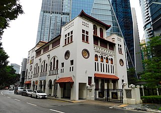
Singapore Hokkien Huay Kuan (SHHK), or the Singapore Hokkien Association in English, is a cultural and educational foundation. It was established in 1840 to promote education, social welfare and the preservation of the Chinese language and culture among Chinese Singaporean and other Overseas Chinese groups in Southeast Asia. As of 2014, the SHHK, which has 5000 members, is the largest clan association in Singapore.

References

  1. 1 2 3 4 5 6 7 8 Savage, Victor R. (2013). Singapore street names : a study of toponymics. Brenda S. A. Yeoh. Singapore. pp. 872–873. ISBN   978-981-4484-74-9. OCLC   868957283.{{cite book}}: CS1 maint: location missing publisher (link)
  2. 1 2 Edwards, Norman (1988). Singapore : a guide to buildings, streets, places. Peter Keys. Singapore: Times Books International. p. 457. ISBN   9971-65-231-5. OCLC   19663390.