Esplanade

Last updated
The Atlantic City, New Jersey boardwalk esplanade, as seen from Caesars Atlantic City, opened in 1870, as the America's first boardwalk. At
.mw-parser-output .frac{white-space:nowrap}.mw-parser-output .frac .num,.mw-parser-output .frac .den{font-size:80%;line-height:0;vertical-align:super}.mw-parser-output .frac .den{vertical-align:sub}.mw-parser-output .sr-only{border:0;clip:rect(0,0,0,0);clip-path:polygon(0px 0px,0px 0px,0px 0px);height:1px;margin:-1px;overflow:hidden;padding:0;position:absolute;width:1px}
5+1/2 miles (9 km) long, it is also the world's longest and busiest boardwalk. New Jersey is home to the world's highest concentration of boardwalk esplanades. Atlantic City Boardwalk view north from Caesars Atlantic City by Silveira Neto June 24 2012.jpg
The Atlantic City, New Jersey boardwalk esplanade, as seen from Caesars Atlantic City, opened in 1870, as the America's first boardwalk. At 5+12 miles (9 km) long, it is also the world's longest and busiest boardwalk. New Jersey is home to the world's highest concentration of boardwalk esplanades.
Central City Park, Macon, GA; May Day, 1876 Central City Park, May Day, 1876 - DPLA - b42178cb2f6ff2dfd3c7d07b805cd814.jpeg
Central City Park, Macon, GA; May Day, 1876

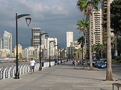
An esplanade or promenade is a long, open, level area, usually next to a river or large body of water, where people may walk. The historical definition of esplanade was a large, open, level area outside fortress or city walls to provide clear fields of fire for the fortress's guns. In modern usage, the space allows the area to be paved as a pedestrian walk; esplanades are often on sea fronts and allow walking whatever the state of the tide, without having to walk on the beach.

Contents

History

In the 19th century, the razing of city fortifications and the relocation of port facilities made it possible in many cities to create promenade paths on the former fortresses and ramparts. The parts of the former fortifications, such as hills, viewpoints, ditches, waterways and lakes have now been included in these promenades, making them popular excursion destinations as well as the location of cultural institutions. The rapid development of artificial street lighting in the 19th century also enabled safe use in the evening. One example of this is Vienna's Ringstrasse.

Esplanades became popular in Victorian times, when it was fashionable to visit seaside resorts. A promenade, often abbreviated to '(the) prom', was an area where people – couples and families especially – would go to walk for a while in order to 'be seen' and be considered part of 'society'. Beach promenades such as the Promenade de la Croisette in Cannes, the famous Promenade des Anglais on the Mediterranean coast in Nice or the Lungomare of Barcola in Trieste still play a central role in city life and in the real estate market.

In the United States, esplanade has another meaning, being also a median (strip of raised land) or berm dividing a roadway or boulevard. Sometimes they are just strips of grass, or some may have gardens and trees. Some roadway esplanades may be used as parks with a walking/jogging trail and benches. [1]

Esplanade and promenade are sometimes used interchangeably. The derivation of "promenade" indicates a place specifically intended for walking, though many modern promenades and esplanades also allow bicycles and other nonmotorized transport. [2] Some esplanades also include large boulevards or avenues where cars are permitted.

A similar term with the same meaning in the eastern coastal region of Spain is alameda Alameda de Hercules, Seville, o rambla, such as La Rambla in Barcelona, but more widely used terms in the rest of the Hispanic world are paseo marítimo ("esplanade"), paseo ("promenade") or explanada ("esplanade").

Examples

Asia

India

Malaysia

Philippines

United Arab Emirates

Others

Americas and Caribbean

United States

Others

Europe

Others

Inland

See also

Related Research Articles

<span class="mw-page-title-main">Wolin</span> Name both of a Polish island and a town on it

Wolin is a Polish island in the Baltic Sea, just off the Polish coast. Administratively, the island belongs to the West Pomeranian Voivodeship. Wolin is separated from the island of Usedom (Uznam) by the Strait of Świna, and from mainland Pomerania by the Strait of Dziwna. The island has an area of 265 km2 (102 sq mi) and its highest point is Mount Grzywacz at 116 m above sea level. The number of inhabitants is 30,000. Eastern suburbs of the city of Świnoujście extend to the Wolin island, while the towns of Międzyzdroje and Wolin lie further east.

<span class="mw-page-title-main">Usedom</span> Island in the southern Baltic Sea divided between Germany and Poland

Usedom is a Baltic Sea island in Pomerania, divided between Germany and Poland. It is the second largest Pomeranian island after Rügen, and the most populous island in the Baltic Sea.

<span class="mw-page-title-main">Świnoujście</span> City in West Pomerania, Poland

Świnoujście is a city in Western Pomerania and seaport on the Baltic Sea and Szczecin Lagoon, located in the extreme north-west of Poland. Situated mainly on the islands of Usedom and Wolin, it also occupies smaller islands. The largest is Karsibór island, once part of Usedom, now separated by the Piast Canal dug in the late 19th century to facilitate ship access to Szczecin.

<span class="mw-page-title-main">Paseo de la Reforma</span> Wide avenue in Mexico City

Paseo de la Reforma is a wide avenue that runs diagonally across the heart of Mexico City. It was designed at the behest of Emperor Maximilian by Ferdinand von Rosenzweig during the era of the Second Mexican Empire and modeled after the great boulevards of Europe, such as the Ringstraße in Vienna and the Champs-Élysées in Paris. The planned grand avenue was to link the National Palace with the imperial residence, Chapultepec Castle, which was then on the southwestern edge of town. The project was originally named Paseo de la Emperatriz in honor of Maximilian's consort Empress Carlota. After the fall of the Empire and Maximilian's subsequent execution, the Restored Republic renamed the Paseo in honor of the La Reforma.

<span class="mw-page-title-main">Iloilo</span> Province in Western Visayas, Philippines

Iloilo, officially the Province of Iloilo, is a province in the Philippines located in the Western Visayas region. Its capital and largest city is Iloilo City, the regional center of Western Visayas. Iloilo occupies the southeast portion of the Visayan island of Panay and is bordered by the province of Antique to the west, Capiz to the north, the Jintotolo Channel to the northeast, the Guimaras Strait to the east, and the Iloilo Strait and Panay Gulf to the southwest.

<span class="mw-page-title-main">Seaside resort</span> Resort located on the coast

A seaside resort is a city, town, village, or hotel that serves as a vacation resort and is located on a coast. Sometimes the concept includes an aspect of official accreditation based on the satisfaction of certain requirements, such as in the German Seebad. Where a beach is the primary focus for tourists, it may be called a beach resort.

<span class="mw-page-title-main">Corniche</span> Road on the side of a cliff or mountain

A corniche is a road on the side of a cliff or mountain, with the ground rising on one side and falling away on the other. The word has been absorbed into English from the French term route à corniche or "road on a ledge", itself derived from the Italian cornice, for "ledge".

<span class="mw-page-title-main">Dipolog</span> Capital of Zamboanga del Norte, Philippines

Dipolog, officially the City of Dipolog, is a 3rd class component city and capital of the province of Zamboanga del Norte, Philippines. According to the 2020 census, it has a population of 138,141 people.

<span class="mw-page-title-main">Iloilo City</span> Capital of Iloilo, Philippines

Iloilo City, officially the City of Iloilo, is a 1st class highly urbanized city in the Western Visayas region of the Philippines, located on the southeastern coast of the island of Panay. It is the capital city of the province of Iloilo, where it is geographically situated and grouped under the Philippine Statistics Authority, but remains politically independent in terms of government and administration. In addition, it is the center of the Iloilo–Guimaras Metropolitan Area, as well as the regional center and primate city of the Western Visayas region. According to the 2020 census, Iloilo City has a population of 457,626 people. For the metropolitan area, the total population is 1,007,945 people.

The Millionaires' Mile, Millionaires' Row, Billionaires Row, Golden Mile or Alpha Street are the exclusive residential neighborhoods of various cities, often along one scenic strip such as a riverside or hilltop drive, or a wide city boulevard.

<span class="mw-page-title-main">Mandurriao</span> District of Iloilo City, Philippines

Mandurriao is a district in Iloilo City, in the province of Iloilo, on the island of Panay, in the Western Visayas region, in the Philippines. It is the second-largest district by land area as well as the third-most populous district, with 62,240 people in the 2020 census. Mandurriao has emerged as the focal point of urban development in Iloilo City, gaining recognition as the future commercial and financial center.

<span class="mw-page-title-main">Arevalo, Iloilo City</span> District of Iloilo City, Philippines

Villa de Arevalo, commonly known as simply Villa or Arevalo, is a district in Iloilo City, in the province of Iloilo, on the island of Panay in Western Visayas region, in the Philippines. According to the 2020 census, it has a population of 55,476 people. Arevalo is situated as the westernmost district of Iloilo City and shares its border with Oton to the west.

<span class="mw-page-title-main">Linear park</span> Long strip of naturally occurring land for recreation

A linear park is a type of park that is significantly longer than it is wide. These linear parks are strips of public land running along canals, rivers, streams, defensive walls, electrical lines, or highways and shorelines. Examples of linear parks include everything from wildlife corridors to riverways to trails, capturing the broadest sense of the word. Other examples include rail trails, which are disused railroad beds converted for recreational use by removing existing structures. Commonly, these linear parks result from the public and private sectors acting on the dense urban need for open green space. Linear parks stretch through urban areas, coming through as a solution for the lack of space and need for urban greenery. They also effectively connect different neighborhoods in dense urban areas as a result, and create places that are ideal for activities such as jogging or walking. Linear parks may also be categorized as greenways. In Australia, a linear park along the coast is known as a foreshoreway. When being designed, linear parks appear unique as they are planned around the public's opinion of how the space will affect them.

<span class="mw-page-title-main">Avenue General de Gaulle</span>

Avenue Général de Gaulle is a seaside, palm-lined street in Beirut, Lebanon. The avenue, which was named in honor of the French general and president Charles de Gaulle, forms with Avenue de Paris the Corniche Beirut promenade. The avenue runs north-south along the Mediterranean coast, from the Manara lighthouse where it connects to Avenue de Paris, skirting around the cliffs of Raouché and the Pigeons' Rocks, down to Boulevard Saeb Salam where it connects to Avenue Rafic Hariri at Ramlet al-Baida beach.

<span class="mw-page-title-main">Padre Burgos Avenue</span> Street in Manila, Philippines

Padre Burgos Avenue, also known as Padre Burgos Street, is a 14-lane thoroughfare in Manila, Philippines.

<span class="mw-page-title-main">Iloilo River Esplanade</span> Linear park in Iloilo City

The Iloilo River Esplanade is a 9-kilometre-long (5.6 mi) urban esplanade and linear park along the Iloilo River in Iloilo City. It stretches on both sides of the river, from Carpenter's Bridge in Mandurriao and Molo districts to Muelle Loney (Drilon) Bridge in the City Proper and Lapuz districts. It is the longest linear park in the Philippines and was designed by landscape architect and PGAA Creative Design founder Paulo Alcazaren. The project is part of the Iloilo River Rehabilitation Project.

<span class="mw-page-title-main">Bonifacio Drive</span> Major road in Manila, Philippines

Bonifacio Drive is a road running for approximately 1 kilometer (0.62 mi) in a north-south direction between Intramuros and Port Area in Manila, Philippines. The boulevard is also designated as Radial Road 1 (R-1) of Manila's arterial road network, National Route 120 (N120) of the Philippine highway network and an auxiliary route of Asian Highway 26 (AH26).

Plaza Mexico is a historic riverside square in Manila, Philippines, located at the west end of Magallanes Drive and Riverside Drive in Intramuros bordering the Pasig River in the north. It is surrounded by the Aduana Building on the south, the Bureau of Immigration Building on the east and the ruins of the Bastión de Maestranza and Puerta de Almacenes on the west. The Pasig River Ferry has a station also named Plaza Mexico located northeast of the square behind the Immigration building. The square was named Plaza Mexico in 1964 to commemorate the 4th centenary of the expedition of Miguel López de Legazpi and Andres de Urdaneta from New Spain (Mexico) and the historic Manila-Acapulco galleon trade relations between the two nations that lasted 250 years.

<span class="mw-page-title-main">Paseo Marítimo de Pontevedra</span> Seafront in Pontevedra, Spain

The paseo marítimo of Pontevedra is a pedestrian way along the seafront facing the ria of Pontevedra, in Pontevedra, Spain. This coastal public space is built in the urban and semi-urban area of the city and defines its encounter with the sea and the Lérez river.

References

  1. "Adopt-An-Esplanade". City of Houston. May 2013.
  2. Tony Russell, Cycling England Archived 2011-01-31 at the Wayback Machine , January 2010
  3. 1 2 Europe's longest beach promenade from Bansin to Świnoujście (12 km)
  4. "New sections of Iloilo Esplanade launched". www.pna.gov.ph. Retrieved 2021-09-04.