 
3) Highways under construction |
|---|
| Sign | Route | Location | Total length | Existing | Construction commenced [p] | Of which under active construction | Scheduled years of opening [7] | Tender | In preparation [q] |
|---|
 | Katowice Airport (A1) - Mysłowice (A4) - Bielsko-Biała (S52) -  / /  (Žilina) (Žilina) | 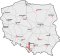 | 144 km | 110.4 km
+ 20.7 km single carriageway | 83.9%
(91%) | 12.9 km
(new route) | 2026, 2027 | | |
(+ 39.5 km)
alternative dual-carriageway road | (100%) | | |
 | Eastern section:
Warsaw (S17) - Międzyrzec P. (S19) - /  (Minsk) (Minsk) |  | 168.2 km | 72.1 km | 42.9% | 63.8 km | 2026, 2029? | 25.5 km | 6.8 km |

 | /  (Berlin) - Szczecin [r] - Goleniów (S3) - Koszalin (S11) - Słupsk - Gdańsk (A1) (Berlin) - Szczecin [r] - Goleniów (S3) - Koszalin (S11) - Słupsk - Gdańsk (A1) |  | 412 km |  276.8 km 276.8 km
 28.1 km 28.1 km | 82% | 56.3 km | 2026 | | |
| Szczecin western bypass | 0 km | 0% | 15.8 km | 2028, 2029, tunnel: 2032? | 35 km | |
 | Gdynia - Gdańsk (A1) - Elbląg (S22) - Olsztynek (S51) - Warsaw (S8) |  | approx. 750 km | 352.2 km | 93.9%
| 9 km
(reconstruction of the 2×2 road to 2×3 highway;2 lanes per each direction are open to traffic on the whole length of the reconstruction site) | 2027, 2032? | | 13 km(reconstruction
+ new route) |
(+ 22 km)
dual carriageway road | (100%) |
| Warsaw (S2) - Radom (S12) - Kielce (S74) - Kraków (A4) | 276 km
+ 3.4 km 1st carriageway | 98% | 2.3 km
+ 3.4 km 2nd carriageway | 2026 | | |
(+ 12.5 km)
auxiliary route through S52 [s] | (100%) |
| Kraków (A4) - Rabka-Zdrój - / (Martin) [t] | 31.8 km | 34.6% | partial reconstruction to grade-separated (2 lanes per direction are open to traffic) | 2030?, 2032?, 2040? [u] | | approx. 60 km(new route) |
(+ 25 km)
dual carriageway road | (62%) |
 | Southern section:
Wrocław (A8) - Kłodzko - /  (Brno) (Brno) |  | approx. 127.4 km | 5.1 km | 4% | 68.8 km | 32 km | 2027, 2028, 2029,
2033?, 2040? | | approx. 53.5 km |
 | Main section:
Szczecin (A6) - Piła (S11) - Bydgoszcz (S5) - Toruń (A1) |  | 297 km | 50.2 km
+ 17.5 km
1st carriageway | 19.8% | 153 km
+ 17.5 km 2nd carriageway | 45.4 km | 2027, 2028,
2030?, 2031? | 37.8 km | 39.5 km |
 | Koszalin (S6) - Piła (S10) - Poznań (A2/S5) - Kępno (S8) - Piekary Śląskie (A1) | 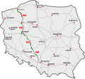 | 556.5 km | 154.4 km
+ 10.5 km
1st carriageway | 28.7% | 122.1 km
+ 4.2 km
2nd carriageway | 25 km | 2026, 2028, 2029,
2031?, 2033? | 78.4 km | 36 km |
+ 155.1 km
+ 6.3 km 2nd c/w |
 | Eastern section:
Lublin (S17/S19) - Chełm - /  (Kyiv) (Kyiv) |  | 103.7 km | 29.2 km | 28.2% | 68.8 km | 14 km | 2026, 2027, 2032? | | 5.7 km |
 | Eastern section:
Lublin (S12/S19) - Zamość - / (Lviv) |  | 126 km | 9.6 km
+ 2 km 1st carriageway | 8.4% | 92 km | 47.7 km | 2027, 2028, 2030?,
2nd c/w: 2032? | 22.3 km | 2 km 2nd carriageway |

Via Carpatia | / (Minsk) - Białystok (S8) - Międzyrzec P. (A2) - Lublin (S12/S17) |  | 572.5 km | 31.2 km
+ 18.5 km 1st carriageway | 12.7% | 198.7 km
+ 18.5 km 2nd carriageway | 122.6 km
+ 13.7 km 2nd carriageway | 2026, 2027, 2028,
2030?, 2031? | 32 km | 37.4 km |
| Lublin (S12/S17) – Rzeszów (A4) | 141.7 km
+ 16.3 km 1st carriageway
with interchanging 2+1 lanes | 94.8%
(100%) | 16.3 km
2nd carriageway | 2026 | | |
| Rzeszów (A4) – / (Košice) | 32.1 km | 33.2% | 64.5 km | 53.8 km | 2026, 2027,
tunnels: 2028, 2030, 2031 | | |
 | Łódź (A1) - Sulejów (S12) - Kielce (S7) - Nisko (S19) |  | approx. 261 km | 16.7 km | 6.4% | 98.6 km | 18.7 km | 2027, 2028,
2032?, 2035? | | 92 km |
| + approx. 54 km |
4) Planned highways |
|---|
| Sign | Route | Location | Total length | Existing | Construction commenced | Of which under active construction | Tender | Predesign complete | In preparation [q] | Planned completion [21] [24] |
|---|
 | Eastern section:
Ostróda (S7) – Grudziądz (A1) | 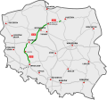 | 101.8 km | 14.3 km | 14% | | | | | 87.5 km | 2033 |
Western section:
Bolków (S3) – Świdnica – S8 | 50.2 km | 0 km | 0% | | | | | 50.2 km | 2032 |
| | Eastern section:
Włocławek (A1) - Płock - Warsaw (S7) | | approx. 120 km | 0 km | 0% | | | | | approx. 120 km | 2033 |
| | Western section:
Piotrków Tryb. (A1) - Sulejów (S74) - Radom (S7) - Lublin (S17) | | 185 km | 16.4 km
+ 6.0 km
1st carriageway | 10.7% | 29.1 km | | 13.2 km | | 120.3 km
+ 6.0 km 2nd c/w | 2033 |
 | Olsztyn (S51) - Ełk (S61) - Białystok (S19) | 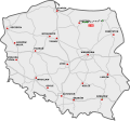 | approx. 245 km | 46.2 km
+ 20.1 km
1st carriageway | 23% | 19.7 km
+ 20.1 km 2nd carriageway | | | | 77.5 km | 2037 |
| + approx. 81.5 km |
| | Warsaw eastern bypass (S8 – S2) | Warsaw | 17.3 km | 3.5 km | 20.2% | | | | | 13.8 km | 2036 |

 | CPK (A2) - Mińsk M. (A2)- CPK | Warsaw
(2nd ring road) | approx. 265 km | 0 km | 0% | | | | | approx. 100 km
approx. 165 km | 2040 |
 | / (Olomouc) - Cieszyn - Bielsko-Biała (S1) - Wadowice - Głogoczów (S7) |  | 98 km | 37 km | 37.8% | | | | | 61 km | 2032 |
In total [b] |
|---|
| Planned length | Existing | Construction commenced [p] | Of which under active construction | Tender | Predesign complete | In preparation | No progress |
|---|
| Total | approx. 8,250 km (5,126 mi) | approx. 2086 km
approx. 6164 km | 5305.2 km
+ 149.8 km
1st carriageway | 65.21% | 1049.4 km
+ 62.5 km
2nd carriageway | 501.3 km
+ 30.4 km
2nd carriageway | 265.6 km | 0 km | approx.
1532.7 km
+ 14.3 km
2nd carriageway | 73 km
2nd c/w [v] |


