
Controlled-access highways in Poland are part of the national roads network and they are divided into motorways and expressways. Both types of highways feature grade-separated interchanges with all other roads, emergency lanes, feeder lanes, wildlife crossings and dedicated roadside rest areas. Motorways differ from expressways in their technical parameters like designated speed, permitted road curvature, lane widths or minimal distances between interchanges. Moreover, expressways might have single-carriageway sections in case of low traffic densities.

According to classes and categories of public roads in Poland, a national road is a public trunk road controlled by the Polish central government authority, the General Directorship of National Roads and Motorways. All motorways and expressways in Poland are classified as part of the national roads network.

According to classes and categories of public roads in Poland, a voivodeship road is a category of roads one step below national roads in importance. The roads are numbered from 100 to 993. Total length of voivodeship roads in Poland is 28,536 km (17,730 mi) of which 61.4 km (38 mi) are unpaved (2008).

Expressway S86 – built from 1978 to 1986 section of national road 86 with a length of 5.9 kilometres (3.7 mi), connecting Katowice with Sosnowiec. In Katowice the road is a part of Walentego Roździeńskiego Avenue. The route has two carriageways with three lanes on each other.

The General Directorate for National Roads and Motorways is the central authority of national administration set up to manage the national roads and implementation of the state budget in Poland. The GDDKiA was established on 1 April 2002 by the Polish Ministry of Transportation.

National road 2 is an A-class, S-class and GP-class Polish national road, being part of the European route E30 from Cork (Ireland) to Omsk (Russia). The highway traverses through the Lubusz, Greater Poland, Łódź. Masovian and Lublin voivodeships. It runs latitudinally.

Droga krajowa nr 98 was a route belonging to Polish national roads network.

Expressway S52 is a Polish highway under construction with a planned length of 116 km (72 mi), located in the Silesian and Lesser Poland voivodeships. Upon completion it will connect the border of the Czech Republic in Cieszyn with Kraków.

National road 92 is a route belonging to Polish national roads network, which serves as an alternative route parallel to motorway A2. The road has one lane per direction on the majority of its length. Before the A2 motorway was constructed, it had served as the main connection between Warsaw, Poznań and the Polish-German border as DK 2; because of this, the route is sometimes referred to as "starą dwójką".

The autostrada A50 is a planned motorway in Poland, in Masovian Voivodeship. It will run as a circular road south of the Warsaw metropolitan area to take over the transit traffic from the existing expressway ring around the city, mainly from the S2 expressway. Once built, the motorway bypass will also be one of the road connectors to the planned Solidarity Transport Hub. It was added to the motorway and expressway index by Polish government on 24 September 2019.

The S50 expressway is a planned expressway in Poland, in Masovian Voivodeship. It will run as a circle road north to the Warsaw metropolitan area to take over the transit traffic from the existing expressway ring around the city, mainly from the S8 and S17 expressways, as well as will be one of the road connectors to the planned Solidarity Transport Hub. It was added to the motorway and expressway index by Polish government on 24 September 2019.
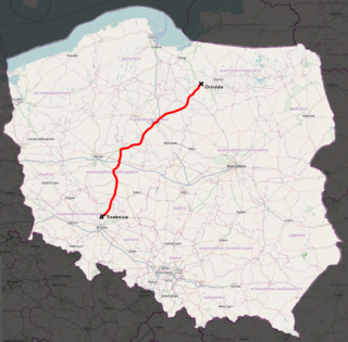
National road 15 is a 374 km long G class and GP class national road connecting Trzebnica with Ostróda. It runs through Lower Silesian Voivodeship, Greater Poland Voivodeship, Kuyavian-Pomeranian Voivodeship and Warmian-Masurian Voivodeship. It serves an alternative to National road 5 on Trzebnica - Gniezno segment while skipping Poznań. Later on it leads through farming lands in Kuyavia to Masuria. It crosses A2 motorway in Września.
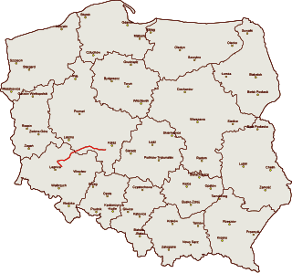
National road 36 is an about 150 km long G class and GP class national road connecting Prochowice in Lower Silesian Voivodeship with Ostrów Wielkopolski in Greater Poland Voivodeship.

National road 54 is a route belonging to the Polish national road network. The highway is a GP-class road, 18 km (11 mi) long, located in the Warmian-Masurian Voivodeship. This route connects the Expressway S22 at the Braniewo-Południe junction near Chruściel with the Gronowo-Mamonovo border crossing near Russia.

National road 53 is a route belonging to the Polish national road network. The highway is a GP-class and G-class road, 123 km (76 mi) long and is located in the Masovian and Warmian-Masurian Voivodeship. This route connects Olsztyn with Ostrołęka. The winding section between Olsztyn and Szczytno is the most difficult for drivers.

National road 52 is a route belonging to the Polish national road network. The highway is a GP-class and S-class road, 72 km (45 mi) long and is located in the Lesser Poland and Silesian Voivodeship. This route consists of two fragments that are not connected with each other. The first one connects Cieszyn through Bielsko-Biała with Głogoczów. The second is the north-west bypass of Kraków.

National road 69 was a route belonging to the Polish national road network. The highway connected Bielsko-Biała with Poland–Slovakia border in Zwardoń.

National road 68 is a main road of accelerated traffic belonging to the Polish national road network. The length of the route is 11.4 kilometres (7.1 mi), of which 5.197 kilometres (3.229 mi) is maintained by General Directorate for National Roads and Highways. The highway connects the Kukuryki border crossing on Belarus–Poland border with national road 2 in Wólka Dobryńska. It runs entirely in Lublin Voivodeship, in Biała County. According to signage, national road 68 is a component of European highway E30.

National road 37 is a main road (Polish: droga główna, droga klasy G) route belonging to Polish national roads network, located in West Pomeranian Voivodeship. With its length of 14.6 kilometres (9.1 mi), the route connects the town of Darłowo with national road 6 near Karwice. In the future a new junction will be constructed, linking road 37 with expressway S6.

National road 96 is a main road of accelerated traffic, belonging to Polish national roads network, with length of 1.5 kilometres (0.93 mi) and located in Toruń County. It connects motorway A1 with national road 15. With its length, the route is the shortest one of all national roads in Poland.A
