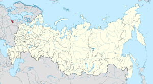
Half of the oblast's one million people live in the city of Kaliningrad, formerly known as Königsberg, which is the provincial capital. Due to sanctions the economy is dependent on subsidies and the military.[11][12] The port city of Baltiysk is Russia's only port on the Baltic Sea that remains ice-free in winter.
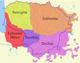
The territory of what is now the Kaliningrad Oblast used to be inhabited by the Old Prussians and other Western Balts, prior to the Teutonic conquest in the early Late Middle Ages.[13] Afterwards, it was settled by Germans (especially the western part), Lithuanians (especially Lithuania Minor) and Poles (especially Königsberg, Polish: Królewiec, and the current southern border strip). The Old Prussians became extinct due to Germanisation in the first half of the 18th century.[14] The Lithuanian-inhabited areas of the Teutonic State were known as Lithuania Minor, which encompassed all of modern Kaliningrad Oblast until the 18th century.[14]
The Northern Crusades, including the Lithuanian Crusade, were partly motivated by colonization.[17] The German colonist peasants, craftsmen, and merchants were predominantly concentrated in the southern part of the Teutonic State and did not move into Nadruvia and Skalvia due to the Lithuanian military threat.[17]
In 1454, following a request by the anti-Teutonic Prussian Confederation, the territory was incorporated to the Kingdom of Poland by King Casimir IV Jagiellon,[18] an event that sparked the Thirteen Years' War (1454–1466). After Poland's victory in the war with the Second Peace of Thorn, the State of the Teutonic Order became a vassal of Poland,[14] also considered an integral part of "one and indivisible" Kingdom of Poland.[19] During this war, the capital of the Teutonic state was moved from Marienburg (now Malbork) to Königsberg in 1457.[14] When the rulers of Prussia were vassals of the King of Poland from 1466 to 1660, there were few German colonists.[14]
In 1577, the Duke of Prussia forbade serfs—who were mostly Old Prussians, Lithuanians, and Masurians—to leave the land that was the property of the German knights who became proprietary nobles.[22]
In 1618, the Duchy merged with the Margraviate of Brandenburg to form Brandenburg-Prussia,[13] remaining under Polish suzerainty until 1660. There was strong opposition to the separation of the region from Poland, especially in Königsberg.[23] A confederation was formed in the city to maintain Poland's sovereignty over the city and region.[23] The Brandenburg Elector and his army, however, entered the city and abducted and imprisoned the leader of the city's anti-Elector opposition Hieronymus Roth.[23] In 1663, the city burghers, forced by Elector Frederick William, swore an oath of allegiance to him, however, in the same ceremony they still also pledged allegiance to Poland.[23]
In 1724, King Frederick William I of Prussia prohibited Poles, Samogitians and Jews from settling in Lithuania Minor, and initiated German colonization to change the region's ethnic composition.[24] In 1734–1736, Königsberg was the place of stay of Polish King Stanisław Leszczyński during the War of the Polish Succession.[25] In 1756 Russia decided to go to war with the Kingdom of Prussia and annex the territory, which was then to be offered to Poland as part of a territorial exchange desired by Russia.[26] The territory was occupied and annexed by Russia in 1758 during the Seven Years' War before being returned to Prussia in 1762 when Russia switched sides in the war.[27] It was then reorganized into the province of East Prussia within the Kingdom of Prussia in 1773.
The current oblast also contains the now abandoned village of Narmeln (Polish: Polski), which was not part of Ducal Prussia, but of the Pomeranian Voivodeship of the Kingdom of Poland until its annexation by the Kingdom of Prussia the Second Partition of Poland in 1793,[28] and is thus part of the historic region of Pomerania.
In the 19th century, East Prussia was commonly viewed by German commentators as culturally backwards and a part of the "German mission in the East" rather than a core German territory. Pan-Germanist politician Ernst Hasse criticised the lack of folk identity and imagined community: "It is the case that there is almost no common folk identity [Landsmannschaften] among the Poseners and Prussians at all. [...] Who can recognise a Posener or Prussian by dialect and character? Distinct features hardly exist."[34] While the north of East Prussia was overwhelmingly German, the south was majority Slavic and mostly composed of Poles and Masurians. There was also a slight Lithuanian majority in the north-eastern area of East Prussia, Lithuania Minor.[35] Regional and local identities were particularly strong in East Prussia - local Polish population often identified with Masuria rather than Poland, and Prussian Lithuanians also did not actively identify themselves with the Lithuanian nation.[36] Moreover, confessional identity often prevailed over the national one - German authorities were concerned about the "Catholic-Polish axis"; German Catholics were alienated from the German nation because of the Kulturkampf legislation, and tended to support the Polish national movement. An East German newspaper Thorner Zeitung reported in 1871 that "not only Polish Catholics, but also a great number of German Catholics, are willing to vote for a Polish party candidate".[37]
By the end of the 19th century, East Prussia had a significant Polish minority, and German nationalist circles warned of the prospect of Polonization of East Prussia.[38] The perceived weakness of Germanness of East Prussia was also reinforced by the Ostflucht, as East Prussia suffered from both underindustrialisation and rural overpopulation. After 1876, farm prices in East Prussia fell by 20 percent, which encouraged local landowners to hire foreign workers from Congress Poland, incidentally strengthening the Polish element in the region. The increased Slavic immigration to the region generated by the requirement of the Junkers for cheap labour and better economic conditions in West Germany caused many German inhabitants to leave the region.[39] Most Germans moved to work in the industrial heartland of western Germany, while others migrated abroad. Poles and Lithuanians of East Prussia also had much higher birth-rate and natural increase rates than the Germans, and rarely emigrated.[40] Discussing the situation in East Prussia, Polish geographer Stanisław Srokowski remarked:
The Poles who live in the southern and western parts of East Prussia and the Lithuanians of the north-west have succeeded better than the Germans in reconciling their mode of life with their earnings. This has, of course, led to a lower standard of life, but it has enabled them to adapt themselves to actual conditions and even to prosper where the Germans fail. Moreover, both these national minorities in East Prussia are bound to the soil by centuries of tradition: they are not comparative new-comers like the majority of the Germans there. For these reasons, the Poles and Lithuanians in that province hardly ever emigrate from the land of their birth, especially as the emigration in question is not so attractive for them as for the Germans: proceeding to central or western Germany, the former would really be going to a foreign country, amongst people not speaking their language and having other customs than theirs.[40]
The Memel Territory (Klaipėda region), formerly part of northeastern East Prussia as well as Prussian Lithuania, was annexed by Lithuania in 1923. In 1938, Nazi Germany radically renamed about a third of the place names of this area, replacing Old Prussian and Lithuanian names with newly invented German names.
In September 1914, after hostilities began between the German Empire on the one hand and France and Russia on the other, the Imperial German Army was about to seize Paris, and the French urged Russia to attack East Prussia. Nicholas II launched a major attack, resulting in a Russian victory in the Battle of Gumbinnen. The Russian army arrived at the outskirts of the city of Königsberg but did not take it and settled at Insterburg. This Russian victory and East Prussia's occupation by Russia saved Paris by forcing the Germans to send many troops to their East provinces.[41] Later, Hindenburg and Ludendorff pushed Russia back at the battle of Tannenberg, thereby liberating East Prussia from Russian troops. Yet Russian troops remained in the easternmost part of the region until early 1915.[42]
On 29 August 1944, Soviet troops reached the border of East Prussia. By January 1945, they had taken all of East Prussia except for the area around Königsberg. Many inhabitants fled west at this time. During the last days of the war, over two million people fled, anticipating imminent Red Army conquest, and were evacuated by sea.
Soviet annexation
Initially, at the end of World War II in 1945, the current southern border strip passed under Polish control with Polish administration organized in the towns of Gierdawy and Iławka, however, the area was eventually annexed by the Soviet Union and included within the Kaliningrad Oblast.[45]
Under the Potsdam Agreement of 1 August 1945, the city became part of the Soviet Union pending the final determination of territorial borders at an anticipated peace settlement. This final determination eventually took place on 12 September 1990 when the Treaty on the Final Settlement with Respect to Germany was signed. The excerpt from the initial agreement pertaining to the partition of East Prussia, including the area surrounding Königsberg, is as follows (note that Königsberg is spelt "Koenigsberg" in the original document):
VI. CITY OF KOENIGSBERG AND THE ADJACENT AREA The Conference examined a proposal by the Soviet Government that pending the final determination of territorial questions at the peace settlement, the section of the western frontier of the Union of Soviet Socialist Republics which is adjacent to the Baltic Sea should pass from a point on the eastern shore of the Bay of Danzig to the east, north of Braunsberg– Goldep, to the meeting point of the frontiers of Lithuania, the Polish Republic and East Prussia.
The Conference has agreed in principle to the proposal of the Soviet Government concerning the ultimate transfer to the Soviet Union of the city of Koenigsberg and the area adjacent to it as described above, subject to expert examination of the actual frontier.
U.S. president Harry Truman and British prime minister Clement Attlee supported the proposal of the Conference at the forthcoming peace settlement.[46]
The monument to Kalinin on the Kalinin Square, built in 1959
In 1946, Königsberg was added as a semi-exclave to the Russian SFSR and renamed Kaliningrad, after the Chairman of the Presidium of the Supreme Soviet of the USSR Mikhail Kalinin. Kalinin was unrelated to the city, and there were already cities named in honour of Kalinin in the Soviet Union, namely Kalinin (now Tver) and Kaliningrad (now Korolev, Moscow Oblast).[47][48] The German language was replaced with the Russian language, and the remaining German population was expelled between 1947 and 1948. The territory was then re-populated with Soviet citizens, mostly ethnic Russians but to a lesser extent also Ukrainians and Belarusians.[49]
Some historians[who?] speculate that it may have originally been offered to the Lithuanian SSR because the resolution from the conference specifies that Kaliningrad's border would be at the (pre-war) Lithuanian frontier. According to some historians[who?], Joseph Stalin created it as an oblast separate from the Lithuanian SSR because it further separated the Baltic states from the West.[50] Others think that the reason was that the region was far too strategic for the USSR to leave it in the hands of another SSR other than the Russian one.[51] In the 1950s, Nikita Khrushchev offered the entire Kaliningrad Oblast to the Lithuanian SSR but Antanas Sniečkus refused to accept the territory because it would add at least a million ethnic Russians to Lithuania proper.[49][52]
Demolition of the Königsberg Castle with explosives, 1959. The last remnants were destroyed by 1968.
In the Soviet era, the city was completely closed and, with the exception of rare visits of friendship from neighboring Poland, it was practically not visited by foreigners.[53][54] In 1950, there were 1,165,000 inhabitants, which was only half the number of the pre-war population. The old city was not restored, and the ruins of the Königsberg Castle were demolished in the late 1960s,[55] on Leonid Brezhnev's personal orders,[55][56] despite the protests of architects, historians and residents of the city.[57][58][59]
The reconstruction of the oblast, threatened by hunger in the immediate post-war years, was carried out through an ambitious policy of oceanic fishing[60] with the creation of one of the main fishing harbours of the USSR in Kaliningrad city. Fishing not only fed the regional economy but also was a basis for social and scientific development, in particular oceanography.[51] From 1953 to 1962, a monument to Stalin stood on Victory Square. In 1973, the town hall was turned into the House of Soviets. In 1975, the trolleybus was launched again. In 1980, a concert hall was opened in the building of the former Lutheran Church of the Holy Family. In 1986, the Kreuzkirche building was transferred to the Russian Orthodox Church.
In 1957, an agreement was signed and later came into force which delimited the border between the Polish People's Republic (a Soviet satellite state at the time) and the Soviet Union.[61][62]
In 2010, the German magazine Der Spiegel published a report claiming that Kaliningrad had been offered to Germany in 1990 (against payment). The offer was not seriously considered by the West German government which, at the time, saw reunification with East Germany as a higher priority.[63] However, this story was later denied by Mikhail Gorbachev.[64]
The independence of Lithuania in 1990 and full dissolution of the Soviet Union in 1991 isolated Kaliningrad from the rest of Russia, having previously been joined by other Soviet republics. This isolation became more severe when both Poland and Lithuania joined NATO and the European Union and imposed strict border controls on Kaliningrad Oblast. All military and civilian land links between the region and the rest of Russia now must pass through members of NATO and the EU. Thus far, the EU has rejected Russian proposals for visa-free travel between Kaliningrad and the rest of Russia. Travel arrangements based on the Facilitated Transit Document (FTD) and Facilitated Rail Transit Document (FRTD) have been made.[66][67] Kaliningrad Oblast's geographic isolation has badly affected its economic situation. Concurrent significant reduction in the size of the Russian military garrison has hurt as well, since previously the military was a major local employer.
Some of the region's cultural heritage, most notably the Königsberg Cathedral, was restored in the 1990s, as citizens started to examine previously ignored German past.[65]
On 12 January 1996, Kaliningrad Oblast and Sverdlovsk Oblast became the first oblasts of Russia to sign a power-sharing treaty with the federal government, granting them autonomy. However, this agreement was abolished on 31 May 2002.[68]
Distribution of Germans in Russia, 2010, demonstrating the higher German presence in the Kaliningrad Oblast compared to other areas in European Russia
After 1991, some ethnic Germans emigrated to the area, such as Volga Germans from other parts of Russia and Kazakhstan. These Germans are overwhelmingly Russian-speaking and as such were rejected for resettlement within Germany under Germany's new rules. A similar migration by Poles from the lands of the former Soviet Union to the Kaliningrad Oblast occurred at this time as well. The situation has begun to change, albeit slowly. Germany, Lithuania, and Poland have renewed contact with Kaliningrad Oblast, through town twinning and other projects. This has helped to promote interest in the history and culture of the East Prussian and Lietuvininkai communities.
In July 2007, Russian First Deputy Prime MinisterSergei Ivanov declared that if US-controlled missile defense systems were deployed in Poland, then nuclear weapons might be deployed in Kaliningrad. On 5 November 2008, Russian president Dmitry Medvedev said that installing missiles in Kaliningrad was almost a certainty.[69] These plans were suspended in January 2009,[70] but implemented in October 2016.[71] In 2011, a long-range Voronezh radar was commissioned to monitor missile launches within about 6,000km (3,700mi). The radar is situated in the settlement of Pionersky in Kaliningrad Oblast.[72]
A few months after the 2022 Russian invasion of Ukraine, Lithuania started implementing EU sanctions, which blocked about 50% of the goods being imported into Kaliningrad by rail. Food, medicine, and passenger travel were exempted. Russia protested against the sanctions and announced it would increase shipments by sea.[73][74] In May 2023, Poland officially adopted a new name for the Kaliningrad region, changing it from "Obwód Kaliningradzki" to "Obwód Królewiecki", Królewiec being the historical Polish name for the city of Kaliningrad. The reason given for the change is that Mikhail Kalinin, a member of the Soviet Politburo, was among those responsible for the Katyn massacre, having co-signed the order to murder thousands of Polish prisoners of war.[75]
Kaliningrad is the only Russian Baltic Sea port that is ice-free all year and hence plays an important role in the maintenance of the country's Baltic Fleet.
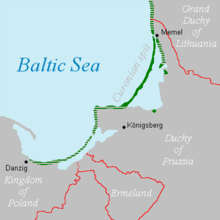
Notable geographical features include the Curonian Lagoon (shared with Lithuania) and the Vistula Lagoon (shared with Poland). The oblast's largest river is the Pregolya. The river starts as a confluence of the Instruch and the Angrapa and drains into the Baltic Sea through the Vistula Lagoon. Its length, strictly under the name "Pregolya", is 123km (76mi); when including the Angrapa, is it 292km (181mi) long.
† Pre-1946 (the German-language names were also used in English in this period)
Climate
The climate of Kaliningrad Oblast gradually transitions from oceanic to humid continental depending on distance from the Baltic Sea moderation. It remains very mild by Russian standards with winters above freezing without the hot summers associated with the Russian interior on similar latitudes. The local climate is slightly wetter than similar latitudes farther west, but infrequent ice days lead to low snow accumulation regardless.
Climate data for Kaliningrad (1991–2020, extremes 1848–present)
As of the 2021 census, the population of the oblast was 1,027,678.[79] Earlier censuses recorded a population of 955,281 in 2002[80] and 871,283 in 1989.[81]
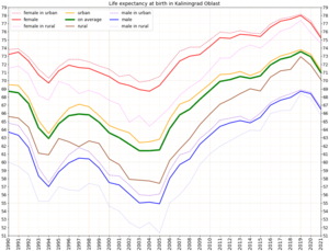
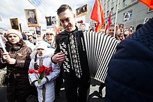
Life expectancy at birth in Kaliningrad OblastKaliningrad's residents taking part in the "Immortal Regiment", carrying portraits of their ancestors who fought in World War II.Epiphanybathing in KaliningradPeople on the beach near Baltiysk
Ethnic groups
According to the 2021 census, the ethnic composition of the oblast was as follows:[82]
Until 1945, the region was overwhelmingly Lutheran, with a small number of Roman Catholics and Jews. The state church of Prussia was dominant in the region. Although it had been both Reformed and Lutheran since 1817, there was an overwhelming Lutheran majority and very few Reformed adherents in East Prussia.
The existence of the oblast's ice-free port and proximity to the European Union are economic advantages.[citation needed] It also has the world's largest deposits of amber. The region has developed its tourism infrastructure and promotes attractions such as the Curonian Spit.[91]
To address the oblast's high rate of unemployment, in 1996 Russian authorities granted the oblast a special economic status that provided tax incentives intended to attract investors. The oblast's economy benefited substantially and boomed. A US$45million airport terminal was opened. The European Commission provided funds for business projects under its special program for the region. Both economic output and trade with the countries of the EU increased.[92]
Industry
Car and truck assembly (GM, BMW, Kia, Yuejin by Avtotor) and the production of auto parts are major industries in Kaliningrad Oblast. There are shipbuilding facilities in Kaliningrad and Sovetsk. Food processing is a mature industry in the region, with Miratorg operating a sizeable food processing factory. OKB Fakel, a world leader in the field of Hall thruster development, as well as a leading Russian developer and manufacturer of electric propulsion systems, is based in Neman. The company employs 960 people.[93][94][obsoletesource] General Satellite (GS) is the biggest employer in Gusev city, manufacturing products such as satellite receivers, cardboard packaging, and nanomaterials.
Natural resources
More than 90% of the world's known amber deposits are in Kaliningrad Oblast.[95] Because of this, many Russians refer to the region as "Amber Land" (Russian: Янтарный Край, romanized:Jantarny Krai). Until recently, raw amber was exported for processing to other countries. In 2013, the Russian government banned the export of raw amber in order to boost the amber processing industry in Russia.[96]
There are small oil reservoirs beneath the Baltic Sea not far from Kaliningrad's shore. Small-scale offshore exploration started in 2004. Poland, Lithuania, and some local NGOs voiced concerns about possible environmental effects.
Fishing
Fishing is an important regional industry,[citation needed] with big fishing ports in Kaliningrad and Pionersky. There are smaller fishing ports in Svetly and Rybachy.
With the desynchronization of the electricity systems of Lithuania, Latvia and Estonia from the Russian UPS synchronous area in February 2025, and their subsequent connection to the Continental Europe Synchronous Area via Poland, the Kaliningrad electrical grid became islanded from any other system.[97]
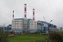
Average yearly power consumption in the Kaliningrad Oblast was 3.5TWh in 2004, of which local power generation provided just 0.235TWh. The balance was imported from neighbouring countries. A new Kaliningrad power station was built in 2005, providing 50% of the oblast's energy needs. This station was expanded in 2010, making the oblast independent from electricity imports.
In 2008, planning began for the construction of two nuclear power reactors, with costs estimated at €5billion (US$8billion).[98] The project was suspended in May 2013. In 2014, the project was abandoned in response to environmental concerns and lack of support.[99]
LNG from St. Petersburg supplied some of the energy in the Oblast.[100]
Agriculture
The grain blight Fusarium graminearum in the oblast is genetically 3ADON, like the blight's strain in Finland and Saint Petersburg.[101] The researchers who discovered the genetic commonality speculate the cause may be a shared population that is distinct from other F.graminearum populations elsewhere.[101]
↑ Президент Российской Федерации.Указ№849от13 мая 2000 г. «О полномочном представителе Президента Российской Федерации в федеральном округе». Вступил в силу13 мая 2000 г. Опубликован: "Собрание законодательства РФ", No.20, ст. 2112, 15 мая 2000 г. (President of the Russian Federation.Decree#849ofMay 13, 2000 On the Plenipotentiary Representative of the President of the Russian Federation in a Federal District. Effective as ofMay 13, 2000.).
↑ Госстандарт Российской Федерации.№ОК 024-9527 декабря 1995 г. «Общероссийский классификатор экономических регионов. 2.Экономические районы», в ред. Изменения №5/2001 ОКЭР. (Gosstandart of the Russian Federation.#OK 024-95December 27, 1995 Russian Classification of Economic Regions. 2.Economic Regions, as amended by the Amendment#5/2001 OKER. ).
1 2 Matulevičius, Algirdas. "Prūsija"[Prussia]. VLE (in Lithuanian). Archived from the original on 7 November 2023. Retrieved 13 May 2022.
1 2 3 4 5 Matulevičius, Algirdas; Kaunas, Domas. "Mažoji Lietuva"[Lithuania Minor]. VLE (in Lithuanian). Archived from the original on 3 February 2023. Retrieved 13 May 2022.
↑ Gudavičius, Edvardas. "Vokiečių ordinas"[German Order]. VLE (in Lithuanian). Archived from the original on 13 February 2024. Retrieved 13 May 2022.
1 2 3 Matulevičius, Algirdas; Purvinas, Martynas. "Karaliaučiaus istorija". VLE (in Lithuanian). Archived from the original on 1 February 2022. Retrieved 13 May 2022.
1 2 Jasas, Rimantas; Kairiūkštytė, Nastazija; Matulevičius, Algirdas. "kolonizacija". VLE (in Lithuanian). Archived from the original on 8 April 2023. Retrieved 13 May 2022.
↑ Górski, Karol (1949). Związek Pruski i poddanie się Prus Polsce: zbiór tekstów źródłowych (in Polish). Poznań: Instytut Zachodni. p.54.
↑ Matulevičius, Algirdas. "Prūsijos kunigaikštystė"[Duchy of Prussia]. VLE (in Lithuanian). Archived from the original on 5 December 2022. Retrieved 13 May 2022.
1 2 3 4 Małłek, Janusz (1992). "Polityka miasta Królewca wobec Polski w latach 1525–1701". Komunikaty Mazursko-Warmińskie (in Polish). No.3–4. pp.254–255.
↑ Ciesielski, Tomasz (2010). "Prusy Wschodnie w trakcie polskiej wojny sukcesyjnej i wojny siedmioletniej". In Gieszczyński, Witold; Kasparek, Norbert (eds.). Wielkie wojny w Prusach. Działania militarne między dolną Wisłą a Niemnem na przestrzeni wieków (in Polish). Dąbrówno. pp.108, 113. ISBN978-83-62552-00-9.{{cite book}}: CS1 maint: location missing publisher (link)
↑ Ciesielski, Tomasz (2010). "Prusy Wschodnie w trakcie polskiej wojny sukcesyjnej i wojny siedmioletniej". In Gieszczyński, Witold; Kasparek, Norbert (eds.). Wielkie wojny w Prusach. Działania militarne między dolną Wisłą a Niemnem na przestrzeni wieków (in Polish). Dąbrówno. p.118. ISBN978-83-62552-00-9.{{cite book}}: CS1 maint: location missing publisher (link)
↑ Biskup, Marian; Tomczak, Andrzej (1955). Mapy województwa pomorskiego w drugiej połowie XVI w. (in Polish). Toruń. p.129.{{cite book}}: CS1 maint: location missing publisher (link)
↑ Hassel, Georg (1823). Statistischer Umriß der sämmtlichen europäischen und der vornehmsten außereuropäischen Staaten, in Hinsicht ihrer Entwickelung, Größe, Volksmenge, Finanz- und Militärverfassung, tabellarisch dargestellt; Erster Heft: Welcher die beiden großen Mächte Österreich und Preußen und den Deutschen Staatenbund darstellt (in German). Verlag des Geographischen Instituts Weimar. p.41.
↑ Mark Jonathan Breedon Tilse (2008). Nations in synthesis: the ideology and practices of transnationalism in the Prussian East, 1871-1914 (Doctoral thesis). University of London. p.63. PQ ETD 591343.
↑ Андрей Павлович Клемешев; Калининградский государственный университет (2004). На перекрёстке культур: русские в Балтийском регионе. Выпуск 7. Часть 2. КГУ. pp.206–207.[clarification needed]
↑ Roqueplo O: La Russie et son Miroir d'Extrême-Occident, Langues'O, HAL, 2018
↑ "Kaliningrad Region – Introduction". Russia: All Regions Trade & Investment Guide. CTEC Publishing LLC. 2008. Archived from the original on 2 October 2009. Retrieved 5 June 2009.
Roqueplo O: La Russie & son Miroir d'Extrême-Occident, Langues'O, HAL, 2018
Областная Дума Калининградской области.Закон№30от18 января 1996 г. «О вступлении в действие Устава (Основного Закона) Калининградской области», в ред. Закона №483 от2 декабря 2015 г«О внесении изменения в Устав (Основной Закон) Калининградской области». Вступил в силупо истечении десяти дней со дня официального публикования, за исключением пункта5 статьи15 и подпункта "б" статьи 22 в части подписания постановлений областной Думы председателем областной Думы, которые введены в действие одновременно со вступлением в силу Федерального закона от 06.10.1999 №184-ФЗ "Об общих принципах организации законодательных (представительных) и исполнительных органов государственной власти субъектов Российской Федерации". Опубликован: "Янтарный край", №20, 26 января 1996 г. (Oblast Duma of Kaliningrad Oblast.Law#30ofJanuary18, 1996 On the Charter (Basic Law) of Kaliningrad Oblast Taking Effect, as amended by the Law#483 ofDecember2, 2015 On Amending the Charter (Basic Law) of Kaliningrad Oblast. Effective as ofthe date ten days after the official publication date, with the exception of item5 of Article15 and the portion of subitem "b" of Article22 dealing with the signing of the resolutions of the Oblast Duma by the Chair of the Oblast Duma, which take effect simultaneously with the Federal Law #184-FZ of October6, 1999 "On the General Principles of the Organization of the Legislative (Representative) and Executive Organs of the State Power in the Federal Subjects of the Russian Federation".).
Калининградская областная Дума.Закон№463от27 мая 2010 г. «Об административно-территориальном устройстве Калининградской области», в ред. Закона №450 от3 июля 2015 г.«О внесении изменений в Закон Калининградской области "Об административно-территориальном устройстве Калининградской области"». Вступил в силусо дня официального опубликования. Опубликован: "Калининградская правда" (вкладыш "Ведомости Правительства Калининградской области"), №112, 26 июня 2010 г. (Kaliningrad Oblast Duma.Law#463ofMay27, 2010 On the Administrative-Territorial Structure of Kaliningrad Oblast, as amended by the Law#450 ofJuly3, 2015 On Amending the Law of Kaliningrad Oblast "On the Administrative-Territorial Structure of Kaliningrad Oblast". Effective as ofthe day of the official publication.).
Simon Grunau, Preußische Chronik. Hrsg. von M. Perlbach etc., Leipzig, 1875.
A. Bezzenberger, Geographie von Preußen, Gotha, 1959
Областная Дума Калининградской области.Закон№30от18 января 1996 г. «О вступлении в действие Устава (Основного Закона) Калининградской области», в ред. Закона №483 от2 декабря 2015 г«О внесении изменения в Устав (Основной Закон) Калининградской области». Вступил в силупо истечении десяти дней со дня официального публикования, за исключением пункта5 статьи15 и подпункта "б" статьи 22 в части подписания постановлений областной Думы председателем областной Думы, которые введены в действие одновременно со вступлением в силу Федерального закона от 06.10.1999 №184-ФЗ "Об общих принципах организации законодательных (представительных) и исполнительных органов государственной власти субъектов Российской Федерации". Опубликован: "Янтарный край", №20, 26 января 1996 г. (Oblast Duma of Kaliningrad Oblast.Law#30ofJanuary18, 1996 On the Charter (Basic Law) of Kaliningrad Oblast Taking Effect, as amended by the Law#483 ofDecember2, 2015 On Amending the Charter (Basic Law) of Kaliningrad Oblast. Effective as ofthe date ten days after the official publication date, with the exception of item5 of Article15 and the portion of subitem "b" of Article22 dealing with the signing of the resolutions of the Oblast Duma by the Chair of the Oblast Duma, which take effect simultaneously with the Federal Law #184-FZ of October6, 1999 "On the General Principles of the Organization of the Legislative (Representative) and Executive Organs of the State Power in the Federal Subjects of the Russian Federation".).
Spuren der Vergangenheit / Следы Пρошлого (Traces of the Past) This site by W. A. Milowskij, a Kaliningrad resident, contains hundreds of interesting photos, often with text explanations, of architectural and infrastructural artifacts of the territory's long German past. (in German and Russian)
This page is based on this Wikipedia article Text is available under the CC BY-SA 4.0 license; additional terms may apply. Images, videos and audio are available under their respective licenses.


