The "Baltic Proper" is bordered on its northern edge, at latitude 60°N, by Åland and the Gulf of Bothnia, on its northeastern edge by the Gulf of Finland, on its eastern edge by the Gulf of Riga, and in the west by the Swedish part of the southern Scandinavian Peninsula.
Geographers widely agree that the preferred physical border between the Baltic and North Seas is the Langelandsbælt (the southern part of the Great Belt strait near Langeland) and the Drogden-Sill strait.[6] The Drogden Sill is situated north of Køge Bugt and connects Dragør in the south of Copenhagen to Malmö; it is used by the Øresund Bridge, including the Drogden Tunnel. By this definition, the Danish straits is part of the entrance, but the Bay of Mecklenburg and the Bay of Kiel are parts of the Baltic Sea. Another usual border is the line between Falsterbo, Sweden, and Stevns Klint, Denmark, as this is the southern border of Øresund. It is also the border between the shallow southern Øresund (with a typical depth of 5–10 meters only) and notably deeper water.
Hydrography and biology
Drogden Sill (depth of 7m (23ft)) sets a limit to Øresund and Darss Sill (depth of 18m (59ft)), and a limit to the Belt Sea.[7] The shallow sills are obstacles to the flow of heavy salt water from the Kattegat into the basins around Bornholm and Gotland.
The Kattegat and the southwestern Baltic Sea are well oxygenated and have a rich biology. The remainder of the Sea is brackish, poor in oxygen, and in species. Thus, statistically, the more of the entrance that is included in its definition, the healthier the Baltic appears; conversely, the more narrowly it is defined, the more endangered its biology appears.
Etymology and nomenclature
The precise origin of the name is unknown. Tacitus called it the Suebic Sea, Latin: Mare Suebicum after the Germanic people of the Suebi,[8][9] and PtolemySarmatian Ocean after the Sarmatians,[10] but the first to name it the Baltic Sea (Medieval Latin: Mare Balticum) was the eleventh-century German chronicler Adam of Bremen. It might be connected to the Germanic word belt, a name used for two of the Danish straits, the Belts, while others claim it to be directly derived from the source of the Germanic word, Latinbalteus "belt".[11] Adam of Bremen himself compared the sea with a belt, stating that it is so named because it stretches through the land as a belt (Balticus, eo quod in modum baltei longo tractu per Scithicas regiones tendatur usque in Greciam).
He might also have been influenced by the name of a legendary island mentioned in the Natural History of Pliny the Elder. Pliny mentions an island named Baltia (or Balcia) with reference to accounts of Pytheas and Xenophon. It is possible that Pliny refers to an island named Basilia ("the royal") in On the Ocean by Pytheas. Baltia also might be derived from "belt", and therein mean "near belt of sea, strait".[citation needed]
Others have suggested that the name of the island originates from the Proto-Indo-European root *bʰel meaning "white, fair",[12] which may echo the naming of seas after colours relating to the cardinal points (as per Black Sea and Red Sea).[13] This *bʰel root and basic meaning were retained in Lithuanian (as baltas), Latvian (as balts) and Slavic (as bely). On this basis, a related hypothesis holds that the name originated from this Indo-European root via a Baltic language such as Lithuanian.[14] Another explanation is that, while derived from the aforementioned root, the name of the sea is related to names for various forms of water and related substances in several European languages, that might have been originally associated with colors found in swamps (compare Proto-Slavic *bolto "swamp"). Yet another explanation is that the name originally meant "enclosed sea, bay" as opposed to open sea.[15]
In the Middle Ages the sea was known by a variety of names. The name Baltic Sea became dominant after 1600. Usage of Baltic and similar terms to denote the region east of the sea started only in the 19th century.[citation needed]
Name in other languages
The Baltic Sea was known in ancient Latin language sources as Mare Suebicum or even Mare Germanicum.[16] Older native names in languages that used to be spoken on the shores of the sea or near it usually indicate the geographical location of the sea (in Germanic languages), or its size in relation to smaller gulfs (in Old Latvian), or tribes associated with it (in Old Russian the sea was known as the Varangian Sea). In modern languages, it is known by the equivalents of "East Sea", "West Sea", or "Baltic Sea" in different languages:
"Baltic Sea" is used in Modern English; in the Baltic languagesLatvian (Baltijas jūra; in Old Latvian it was referred to as "the Big Sea", while the present day Gulf of Riga was referred to as "the Little Sea") and Lithuanian (Baltijos jūra); in Latin (Mare Balticum) and the Romance languagesFrench (Mer Baltique), Italian (Mar Baltico), Portuguese (Mar Báltico), Romanian (Marea Baltică) and Spanish (Mar Báltico); in Greek (Βαλτική ΘάλασσαValtikí Thálassa); in Albanian (Deti Balltik); in Welsh (Môr Baltig); in the Slavic languagesPolish (Morze Bałtyckie or Bałtyk), Czech (Baltské moře or Balt), Slovene (Baltsko morje), Bulgarian (Балтийско мореBaltijsko More), Kashubian (Bôłt), Macedonian (Балтичко МореBaltičko More), Ukrainian (Балтійське мореBaltijs′ke More), Belarusian (Балтыйскае мораBaltyjskaje Mora), Russian (Балтийское мореBaltiyskoye More) and Serbo-Croatian (Baltičko more / Балтичко море); in Hungarian (Balti-tenger).
In Germanic languages, except English, "East Sea" is used, as in Afrikaans (Oossee), Danish (Østersøen[ˈøstɐˌsøˀn̩]), Dutch (Oostzee), German (Ostsee), Low German (Oostsee), Icelandic and Faroese (Eystrasalt), Norwegian (Bokmål: Østersjøen[ˈø̂stəˌʂøːn]; Nynorsk: Austersjøen), and Swedish (Östersjön). In Old English it was known as Ostsǣ,[17] which does not however mean 'east sea' and may be related to a people known in the same work as the Osti.[18] Also in Hungarian the former name was Keleti-tenger ("East-sea", due to German influence). In addition, Finnish, a Finnic language, uses the term Itämeri "East Sea", possibly a calque from a Germanic language. As the Baltic is not particularly eastward in relation to Finland, the use of this term may be a leftover from the period of Swedish rule.
In another Finnic language, Estonian, it is called the "West Sea" (Läänemeri), with the correct geography relative to Estonia (the sea being to its west). In South Estonian, it has the meaning of both "West Sea" and "Evening Sea" (Õdagumeri). In the endangered Livonian language of Latvia, it (and sometimes the Irbe Strait as well) is called the "Large Sea" (Sūŗ meŗ or Sūr meŗ).[19][20]
History
Classical world
At the time of the Roman Empire, the Baltic Sea was known as the Mare Suebicum or Mare Sarmaticum. Tacitus in his AD98 Agricola and Germania described the Mare Suebicum, named for the Suebi tribe, during the spring months, as a brackish sea where the ice broke apart and chunks floated about. The Suebi eventually migrated southwest to temporarily reside in the Rhineland area of modern Germany, where their name survives in the historic region known as Swabia. Jordanes called it the Germanic Sea in his work, the Getica.[21][22]
Middle Ages
Cape Arkona on the island of Rügen in Germany was a sacred site of the Rani tribe before Christianization.
In the early Middle Ages, Norse (Scandinavian) merchants built a trade empire all around the Baltic. Later, the Norse fought for control of the Baltic against Wendish tribes dwelling on the southern shore. The Norse also used the rivers of Russia for trade routes, finding their way eventually to the Black Sea and southern Russia. This Norse-dominated period is referred to as the Viking Age.[citation needed]
Since the Viking Age, the Scandinavians have referred to the Baltic Sea as Austmarr ("Eastern Sea"). "Eastern Sea", appears in the Heimskringla and Eystra salt appears in Sörla þáttr. Saxo Grammaticus recorded in Gesta Danorum an older name, Gandvik, -vik being Old Norse for "bay", which implies that the Vikings correctly regarded it as an inlet of the sea. Another form of the name, "Grandvik", attested in at least one English translation of Gesta Danorum, is likely to be a misspelling.[citation needed]
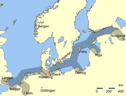
In addition to fish the sea also provides amber, especially from its southern shores within today's borders of Poland, Russia and Lithuania. First mentions of amber deposits on the South Coast of the Baltic Sea date back to the 12th century.[23] The bordering countries have also traditionally exported lumber, wood tar, flax, hemp and furs by ship across the Baltic. Sweden had from early medieval times exported iron and silver mined there, while Poland had and still has extensive salt mines. Thus, the Baltic Sea has long been crossed by much merchant shipping.[24]
Starting in the 11th century, the southern and eastern shores of the Baltic were settled by migrants mainly from Germany, a movement called the Ostsiedlung ("east settling"). Other settlers were from the Netherlands, Denmark, and Scotland. The Polabian Slavs were gradually assimilated by the Germans.[26]Denmark gradually gained control over most of the Baltic coast, until she lost much of her possessions after being defeated in the 1227 Battle of Bornhöved.[citation needed]
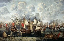
The naval Battle of the Sound took place on 8 November 1658 during the Dano-Swedish War.Nautical chart of the Baltic Sea in 1919The burning Cap Arcona shortly after the attacks, 3 May 1945. Only 350 survived of the 4,500 prisoners who had been aboard.
Between the 13th and 17th centuries the Baltic Sea was, depending on the period, dominated by the Netherlands, Germany, Sweden and Russia.[27] In the 13th to 16th centuries, the strongest economic force in Northern Europe was the Hanseatic League, a federation of merchant cities around the Baltic Sea and the North Sea. In the sixteenth and early seventeenth centuries, Poland, Denmark, and Sweden fought wars for Dominium maris baltici ("Lordship over the Baltic Sea"). Eventually, it was Sweden that virtually encompassed the Baltic Sea. In Sweden, the sea was then referred to as Mare Nostrum Balticum ("Our Baltic Sea"). The goal of Swedish warfare during the 17th century was to make the Baltic Sea an all-Swedish sea (Ett Svenskt innanhav), something that was accomplished except the part between Riga in Latvia and Stettin in Pomerania. However, the Dutch dominated the Baltic trade in the seventeenth century.[citation needed]
In the eighteenth century, Russia and Prussia became the leading powers over the sea. Sweden's defeat in the Great Northern War brought Russia to the eastern coast. Russia became and remained a dominating power in the Baltic. Russia's Peter the Great saw the strategic importance of the Baltic and decided to found his new capital, Saint Petersburg, at the mouth of the Neva river at the east end of the Gulf of Finland. There was much trading not just within the Baltic region but also with the North Sea region, especially eastern England and the Netherlands: their fleets needed the Baltic timber, tar, flax, and hemp.[citation needed]
During the Crimean War, a joint British and French fleet attacked the Russian fortresses in the Baltic; the case is also known as the Åland War. They bombarded Sveaborg, which guards Helsinki; and Kronstadt, which guards Saint Petersburg; and they destroyed Bomarsund in Åland. After the unification of Germany in 1871, the whole southern coast became German. World War I was partly fought in the Baltic Sea. After 1920 Poland was granted access to the Baltic Sea at the expense of Germany by the Polish Corridor and enlarged the port of Gdynia in rivalry with the port of the Free City of Danzig.[28]
After the Nazis' rise to power, Germany reclaimed the Memelland and after the outbreak of the Eastern Front (World War II) occupied the Baltic states. In 1945, the Baltic Sea became a mass grave for retreating soldiers and refugees on torpedoed troop transports. The sinking of the Wilhelm Gustloff remains the worst maritime disaster in history, killing (very roughly) 9,000 people. In 2005, a Russian group of scientists found over five thousand airplane wrecks, sunken warships, and other material, mainly from World War II, on the bottom of the sea.[citation needed]
Since World War II
Ammunition dumping
Since the end of World War II, various nations, including the Soviet Union, the United Kingdom and the United States have disposed of chemical weapons in the Baltic Sea, raising concerns of environmental contamination.[29] Today, fishermen occasionally find some of these materials: the most recent available report from the Helsinki Commission notes that four small scale catches of chemical munitions representing approximately 105kg (231lb) of material were reported in 2005. This is a reduction from the 25 incidents representing 1,110kg (2,450lb) of material in 2003.[30] Until now, the U.S. Government refuses to disclose the exact coordinates of the wreck sites. Deteriorating bottles leak mustard gas and other substances, thus slowly poisoning a substantial part of the Baltic Sea.[citation needed]
In addition to chemicals, tons of German ammunition were dumped into the Baltic after the war at the behest of the Allies, who wanted to ensure that they would not start another war. By 2025, these were leaking contaminates into the water and the German government was piloting solutions.[31]
In 1981, the Soviet submarine S-363 ran on ground deep inside Swedish territorial waters, an incident which illustrated the impact of the Cold War on the Baltic Sea.
Finland and Sweden joined NATO in 2023 and 2024, respectively, making the Baltic Sea almost entirely surrounded by the alliance's members, leading some commentators to label the sea a "NATO lake".[34][35][36][37][38] However, the legal status of the sea has not changed and it is still open to all nations.[39] Such an arrangement has also existed for the European Union (EU) since May 2004 following the accession of the Baltic states and Poland. The remaining non-NATO and non-EU shore areas are Russian: the Saint Petersburg area and the Kaliningrad Oblastexclave.[citation needed]
These events followed a series of responses from both NATO and the EU. In response, NATO Baltic Sea states have increased their naval presence in the Baltic Sea, and the NATO operation Baltic Sentry was established. Simultaneously, the EU has implemented a series of measures designed to enhance the protection of critical maritime infrastructure. The EU has also underscored the commitment to strengthening cooperation with NATO.[47]
Storms and storm floods
Winter storms begin arriving in the region during October. These have caused numerous shipwrecks, and contributed to the extreme difficulties of rescuing passengers of the ferry MS Estonia en route from Tallinn, Estonia, to Stockholm, Sweden, in September 1994, which claimed the lives of 852 people. Older, wood-based shipwrecks such as the Vasa tend to remain well-preserved, as the Baltic's cold and brackish water does not suit the shipworm.
Storm surge floods are generally taken to occur when the water level is more than one metre above normal. In Warnemünde about 110 floods occurred from 1950 to 2000, an average of just over two per year.[48]
Historic flood events were the All Saints' Flood of 1304 and other floods in the years 1320, 1449, 1625, 1694, 1784 and 1825. Little is known of their extent.[49] From 1872, there exist regular and reliable records of water levels in the Baltic Sea. The highest was the flood of 1872 when the water was an average of 2.43m (8ft 0in) above sea level at Warnemünde and a maximum of 2.83m (9ft 3in) above sea level in Warnemünde. In the last very heavy floods the average water levels reached 1.88m (6ft 2in) above sea level in 1904, 1.89m (6ft 2in) in 1913, 1.73m (5ft 8in) in January 1954, 1.68m (5ft 6in) on 2–4 November 1995 and 1.65m (5ft 5in) on 21 February 2002.[50]
Geography
Geophysical data
Baltic drainage basins (catchment area), with depth, elevation, major rivers and lakesCuronian Lagoon, Spit and Klaipėda
It is about 1,600km (990mi) long, an average of 193km (120mi) wide, and an average of 55 metres (180ft) deep. The maximum depth is 459m (1,506ft) which is on the Swedish side of the center. The surface area is about 349,644km2 (134,998sqmi)[51] and the volume is about 20,000km3 (4,800cumi). The periphery amounts to about 8,000km (5,000mi) of coastline.[52]
The Baltic Sea is one of the largest brackish inland seas by area, and occupies a basin (a Zungenbecken) formed by glacial erosion during the last few ice ages.
Physical characteristics of the Baltic Sea, its main sub-regions, and the transition zone to the Skagerrak/North Sea area[53]
Bordered by the coasts of Germany, Denmark, Poland, Sweden, Finland, Russia, Estonia, Latvia, and Lithuania, it extends north-eastward of the following limits:
The Northern Baltic Sea lies between the Stockholm area, southwestern Finland, and Estonia. The Western and Eastern Gotland basins form the major parts of the Central Baltic Sea or Baltic proper. The Bornholm Basin is the area east of Bornholm, and the shallower Arkona Basin extends from Bornholm to the Danish isles of Falster and Zealand.
Satellite image of the Baltic Sea in a mild winterTraversing Baltic Sea and iceOn particularly cold winters, the coastal parts of the Baltic Sea freeze into ice thick enough to walk or ski on.
The water temperature of the Baltic Sea varies significantly depending on exact location, season and depth. At the Bornholm Basin, which is located directly east of the island of the same name, the surface temperature typically falls to 0–5°C (32–41°F) during the peak of the winter and rises to 15–20°C (59–68°F) during the peak of the summer, with an annual average of around 9–10°C (48–50°F).[56] A similar pattern can be seen in the Gotland Basin, which is located between the island of Gotland and Latvia. In the deep of these basins the temperature variations are smaller. At the bottom of the Bornholm Basin, deeper than 80m (260ft), the temperature typically is 1–10°C (34–50°F), and at the bottom of the Gotland Basin, at depths greater than 225m (738ft), the temperature typically is 4–7°C (39–45°F).[56] Generally, offshore locations, lower latitudes and islands maintain maritime climates, but adjacent to the water continental climates are common, especially on the Gulf of Finland. In the northern tributaries the climates transition from moderate continental to subarctic on the northernmost coastlines.
On the long-term average, the Baltic Sea is ice-covered at the annual maximum for about 45% of its surface area. The ice-covered area during such a typical winter includes the Gulf of Bothnia, the Gulf of Finland, the Gulf of Riga, the archipelago west of Estonia, the Stockholm archipelago, and the Archipelago Sea southwest of Finland. The remainder of the Baltic does not freeze during a normal winter, except sheltered bays and shallow lagoons such as the Curonian Lagoon. The ice reaches its maximum extent in February or March; typical ice thickness in the northernmost areas in the Bothnian Bay, the northern basin of the Gulf of Bothnia, is about 70cm (28in) for landfast sea ice. The thickness decreases farther south.
Freezing begins in the northern extremities of the Gulf of Bothnia typically in the middle of November, reaching the open waters of the Bothnian Bay in early January. The Bothnian Sea, the basin south of Kvarken, freezes on average in late February. The Gulf of Finland and the Gulf of Riga freeze typically in late January. In 2011, the Gulf of Finland was completely frozen on 15 February.[57]
The ice extent depends on whether the winter is mild, moderate, or severe. In severe winters ice can form around southern Sweden and even in the Danish straits. According to the 18th-century natural historian William Derham, during the severe winters of 1703 and 1708, the ice cover reached as far as the Danish straits.[58] Frequently, parts of the Gulf of Bothnia and the Gulf of Finland are frozen, in addition to coastal fringes in more southerly locations such as the Gulf of Riga. This description meant that the whole of the Baltic Sea was covered with ice.
Since 1720, the Baltic Sea has frozen over entirely 20 times, most recently in early 1987, which was the most severe winter in Scandinavia since 1720. The ice then covered 400,000km2 (150,000sqmi). During the winter of 2010–11, which was quite severe compared to those of the last decades, the maximum ice cover was 315,000km2 (122,000sqmi), which was reached on 25 February 2011. The ice then extended from the north down to the northern tip of Gotland, with small ice-free areas on either side, and the east coast of the Baltic Sea was covered by an ice sheet about 25 to 100km (16 to 62mi) wide all the way to Gdańsk. This was brought about by a stagnant high-pressure area that lingered over central and northern Scandinavia from around 10 to 24 February. After this, strong southern winds pushed the ice further into the north, and much of the waters north of Gotland were again free of ice, which had then packed against the shores of southern Finland.[59] The effects of the aforementioned high-pressure area did not reach the southern parts of the Baltic Sea, and thus the entire sea did not freeze over. However, floating ice was additionally observed near Świnoujście harbor in January 2010.
In recent years before 2011, the Bothnian Bay and the Bothnian Sea were frozen with solid ice near the Baltic coast and dense floating ice far from it. In 2008, almost no ice formed except for a short period in March.[60]
Piles of drift ice on the shore of Puhtulaid, near Virtsu, Estonia, in late April
During winter, fast ice, which is attached to the shoreline, develops first, rendering ports unusable without the services of icebreakers. Level ice, ice sludge, pancake ice, and rafter ice form in the more open regions. The gleaming expanse of ice is similar to the Arctic, with wind-driven pack ice and ridges up to 15m (49ft). Offshore of the landfast ice, the ice remains very dynamic all year, and it is relatively easily moved around by winds and therefore forms pack ice, made up of large piles and ridges pushed against the landfast ice and shores.
In spring, the Gulf of Finland and the Gulf of Bothnia normally thaw in late April, with some ice ridges persisting until May in the eastern extremities of the Gulf of Finland. In the northernmost reaches of the Bothnian Bay, ice usually stays until late May; by early June it is practically always gone. However, in the famine year of 1867 remnants of ice were observed as late as 17 July near Uddskär.[61] Even as far south as Øresund, remnants of ice have been observed in May on several occasions; near Taarbaek on 15 May 1942 and near Copenhagen on 11 May 1771. Drift ice was also observed on 11 May 1799.[62][63][64]
The ice cover is the main habitat for two large mammals, the grey seal (Halichoerus grypus) and the Baltic ringed seal (Pusa hispida botnica), both of which feed underneath the ice and breed on its surface. Of these two seals, only the Baltic ringed seal suffers when there is not adequate ice in the Baltic Sea, as it feeds its young only while on ice. The grey seal is adapted to reproducing also with no ice in the sea. The sea ice also harbors several species of algae that live in the bottom and inside unfrozen brine pockets in the ice.
Due to the often fluctuating winter temperatures between above and below freezing, the saltwater ice of the Baltic Sea can be treacherous and hazardous to walk on, in particular in comparison to the more stable fresh water-ice sheets in the interior lakes.
Hydrography
Depths of the Baltic Sea in meters
The Baltic Sea flows out through the Danish straits; however, the flow is complex. A surface layer of brackish water discharges 940km3 (230cumi) per year into the North Sea. Due to the difference in salinity, by salinity permeation principle, a sub-surface layer of more saline water moving in the opposite direction brings in 475km3 (114cumi) per year. It mixes very slowly with the upper waters, resulting in a salinity gradient from top to bottom, with most of the saltwater remaining below 40 to 70m (130 to 230ft) deep. The general circulation is anti-clockwise: northwards along its eastern boundary, and south along with the western one.[65]
The difference between the outflow and the inflow comes entirely from fresh water. More than 250 streams drain a basin of about 1,600,000km2 (620,000sqmi), contributing a volume of 660km3 (160cumi) per year to the Baltic. They include the major rivers of north Europe, such as the Oder, the Vistula, the Neman, the Daugava and the Neva. Additional fresh water comes from the difference of precipitation less evaporation, which is positive.
An important source of salty water is infrequent inflows (also known as major Baltic inflows or MBIs) of North Sea water into the Baltic. Such inflows, important to the Baltic ecosystem because of the oxygen they transport into the Baltic deeps, happen on average once per year, but large pulses that can replace the anoxic deep water in the Gotland Deep occur about once in ten years. Previously, it was believed that the frequency of MBIs had declined since 1980, but recent studies have challenged this view and no longer display a clear change in the frequency or intensity of saline inflows. Instead, a decadal variability in the intensities of MBIs is observed with a main period of approximately 30 years.[66][67]
The water level is generally far more dependent on the regional wind situation than on tidal effects. However, tidal currents occur in narrow passages in the western parts of the Baltic Sea. Tides can reach 17 to 19cm (6.7 to 7.5in) in the Gulf of Finland.[68]
The significant wave height is generally much lower than that of the North Sea. Quite violent, sudden storms sweep the surface ten or more times a year, due to large transient temperature differences and a long reach of the wind. Seasonal winds also cause small changes in sea level, of the order of 0.5m (1ft 8in) .[65] According to the media, during a storm in January 2017, an extreme wave above 14m (46ft) has been measured and significant wave height of around 8m (26ft) has been measured by the FMI. A numerical study has shown the presence of events with 8 to 10m (26 to 33ft) significant wave heights. Those extreme waves events can play an important role in the coastal zone on erosion and sea dynamics.[69]
The Baltic Sea is the world's largest brackish sea.[70] Only two other brackish waters are larger according to some measurements: The Black Sea is larger in both surface area and water volume, but most of it is located outside the continental shelf (only a small fraction is inland). The Caspian Sea is larger in water volume, but—despite its name—it is a lake rather than a sea.[70]
The Baltic Sea's salinity is much lower than that of ocean water (which averages 3.5%), as a result of abundant freshwater runoff from the surrounding land (rivers, streams and alike), combined with the shallowness of the sea itself; runoff contributes roughly one-fortieth its total volume per year, as the volume of the basin is about 21,000km3 (5,000cumi) and yearly runoff is about 500km3 (120cumi).[citation needed]
The open surface waters of the Baltic Sea "proper" generally have a salinity of 0.3 to 0.9%, which is border-line freshwater. The flow of freshwater into the sea from approximately two hundred rivers and the introduction of salt from the southwest builds up a gradient of salinity in the Baltic Sea. The highest surface salinities, generally 0.7–0.9%, are in the southwestern most part of the Baltic, in the Arkona and Bornholm basins (the former located roughly between southeast Zealand and Bornholm, and the latter directly east of Bornholm). It gradually falls further east and north, reaching the lowest in the Bothnian Bay at around 0.3%.[71] Drinking the surface water of the Baltic as a means of survival would actually hydrate the body instead of dehydrating, as is the case with ocean water.[note 1][citation needed]
As saltwater is denser than freshwater, the bottom of the Baltic Sea is saltier than the surface. This creates a vertical stratification of the water column, a halocline, that represents a barrier to the exchange of oxygen and nutrients, and fosters completely separate maritime environments.[72] The difference between the bottom and surface salinities varies depending on location. Overall it follows the same southwest to east and north pattern as the surface. At the bottom of the Arkona Basin (equaling depths greater than 40m or 130ft) and Bornholm Basin (depths greater than 80m or 260ft) it is typically 1.4–1.8%. Further east and north the salinity at the bottom is consistently lower, being the lowest in Bothnian Bay (depths greater than 120m or 390ft) where it is slightly below 0.4%, or only marginally higher than the surface in the same region.[71]
In contrast, the salinity of the Danish straits, which connect the Baltic Sea and Kattegat, tends to be significantly higher, but with major variations from year to year. For example, the surface and bottom salinity in the Great Belt is typically around 2.0% and 2.8% respectively, which is only somewhat below that of the Kattegat.[71] The water surplus caused by the continuous inflow of rivers and streams to the Baltic Sea means that there generally is a flow of brackish water out through the Danish straits to the Kattegat (and eventually the Atlantic).[73] Significant flows in the opposite direction, salt water from the Kattegat through the Danish straits to the Baltic Sea, are less regular and are known as major Baltic inflows (MBIs).
The rating of mean discharges differs from the ranking of hydrological lengths (from the most distant source to the sea) and the rating of the nominal lengths. Göta älv, a tributary of the Kattegat, is not listed, as due to the northward upper low-salinity-flow in the sea, its water hardly reaches the Baltic proper:
Population density in the Baltic Sea catchment area
Countries that border the sea: Denmark, Estonia, Finland, Germany, Latvia, Lithuania, Poland, Russia, Sweden.
Countries lands in the outer drainage basin: Belarus, Czech Republic, Norway, Slovakia, Ukraine.
The Baltic Sea drainage basin is roughly four times the surface area of the sea itself. About 48% of the region is forested, with Sweden and Finland containing the majority of the forest, especially around the Gulfs of Bothnia and Finland.
About 20% of the land is used for agriculture and pasture, mainly in Poland and around the edge of the Baltic Proper, in Germany, Denmark, and Sweden. About 17% of the basin is unused open land with another 8% of wetlands. Most of the latter are in the Gulfs of Bothnia and Finland.
The rest of the land is heavily populated. About 85million people live in the Baltic drainage basin, 15million within 10km (6mi) of the coast and 29million within 50km (31mi) of the coast. Around 22million live in population centers of over 250,000. 90% of these are concentrated in the 10km (6mi) band around the coast. Of the nations containing all or part of the basin, Poland includes 45% of the 85million, Russia 12%, Sweden 10% and the others less than 6% each.[74]
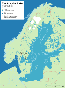
Ancylus Lake around 8700 years BP. The relic of Scandinavian Glacier in white. The rivers Svea älv (Svea river) and Göta älv formed an outlet to the Atlantic.
Much of modern Finland is former seabed or archipelago: illustrated are sea levels immediately after the last ice age.
The Baltic Sea somewhat resembles a riverbed, with two tributaries, the Gulf of Finland and Gulf of Bothnia. Geological surveys show that before the Pleistocene, instead of the Baltic Sea, there was a wide plain around a great river that paleontologists call the Eridanos. Several Pleistocene glacial episodes scooped out the river bed into the sea basin. By the time of the last, or Eemian Stage (MIS5e), the Eemian Sea was in place. Sometimes the Baltic Sea is considered a very large estuary, with freshwater outflow from numerous rivers.[76]
From that time the waters underwent a geologic history summarized under the names listed below. Many of the stages are named after marine animals (e.g. the Littorinamollusk) that are clear markers of changing water temperatures and salinity.
The factors that determined the sea's characteristics were the submergence or emergence of the region due to the weight of ice and subsequent isostatic readjustment, and the connecting channels it found to the North Sea-Atlantic, either through the straits of Denmark or at what are now the large lakes of Sweden, and the White Sea-Arctic Sea. There are a number of named and dated stages in the evolution of the Baltic Sea:[77]
The land is still emerging isostatically from its depressed state, which was caused by the weight of ice during the last glaciation. The phenomenon is known as post-glacial rebound. Consequently, the surface area and the depth of the sea are diminishing. The uplift is about eight millimeters per year on the Finnish coast of the northernmost Gulf of Bothnia. In the area, the former seabed is only gently sloping, leading to large areas of land being reclaimed in what are, geologically speaking, relatively short periods (decades and centuries).
The fauna of the Baltic Sea is a mixture of marine and freshwater species. Among marine fishes are Atlantic cod, Atlantic herring, European hake, European plaice, European flounder, shorthorn sculpin and turbot, and examples of freshwater species include European perch, northern pike, whitefish and common roach. Freshwater species may occur at outflows of rivers or streams in all coastal sections of the Baltic Sea. Otherwise, marine species dominate in most sections of the Baltic, at least as far north as Gävle, where less than one-tenth are freshwater species. Further north the pattern is inverted. In the Bothnian Bay, roughly two-thirds of the species are freshwater. In the far north of this bay, saltwater species are almost entirely absent.[56] For example, the common starfish and shore crab, two species that are very widespread along European coasts, are both unable to cope with the significantly lower salinity. Their range limit is west of Bornholm, meaning that they are absent from the vast majority of the Baltic Sea.[56] Some marine species, like the Atlantic cod and European flounder, can survive at relatively low salinities but need higher salinities to breed, which therefore occurs in deeper parts of the Baltic Sea.[78][79] The common blue mussel is the dominating animal species, and makes up more than 90% of the total animal biomass in the sea.[80]
There is a decrease in species richness from the Danish belts to the Gulf of Bothnia. The decreasing salinity along this path causes restrictions in both physiology and habitats.[81] At more than 600 species of invertebrates, fish, aquatic mammals, aquatic birds and macrophytes, the Arkona Basin (roughly between southeast Zealand and Bornholm) is far richer than other more eastern and northern basins in the Baltic Sea, which all have less than 400 species from these groups, with the exception of the Gulf of Finland with more than 750 species. However, even the most diverse sections of the Baltic Sea have far fewer species than the almost-full saltwater Kattegat, which is home to more than 1600 species from these groups.[56] The lack of tides has affected the marine species as compared with the Atlantic.
Since the Baltic Sea is so young there are only two or three known endemic species: the brown alga Fucus radicans and the flounder Platichthys solemdali. Both appear to have evolved in the Baltic basin and were only recognized as species in 2005 and 2018 respectively, having formerly been confused with more widespread relatives.[79][82] The tiny Copenhagen cockle (Parvicardium hauniense), a rare mussel, is sometimes considered endemic, but has now been recorded in the Mediterranean.[83] However, some consider non-Baltic records to be misidentifications of juvenile lagoon cockles (Cerastoderma glaucum).[84] Several widespread marine species have distinctive subpopulations in the Baltic Sea adapted to the low salinity, such as the Baltic Sea forms of the Atlantic herring and lumpsucker, which are smaller than the widespread forms in the North Atlantic.[73]
Satellite photo of the Baltic Sea surrounding Gotland, Sweden, with algae bloom (phytoplankton) swirling in the water
Satellite images taken in July 2010 revealed a massive algal bloom covering 377,000 square kilometres (146,000mi2) in the Baltic Sea. The area of the bloom extended from Germany and Poland to Finland. Researchers of the phenomenon have found that algal blooms have occurred every summer for decades. Fertilizer runoff from surrounding agricultural land has exacerbated the problem and led to increased eutrophication.[100]
Approximately 100,000km2 (38,610sqmi) of the Baltic's seafloor (a quarter of its total area) is a variable dead zone. The more saline (and therefore denser) water remains on the bottom, isolating it from surface waters and the atmosphere. This leads to decreased oxygen concentrations within the zone. It is mainly bacteria that grow in it, digesting organic material and releasing hydrogen sulfide. Because of this large anaerobic zone, the seafloor ecology differs from that of the neighboring Atlantic.
Plans to artificially oxygenate areas of the Baltic that have experienced eutrophication have been proposed by the University of Gothenburg and Inocean AB. The proposal intends to use wind-driven pumps to pump oxygen-rich surface water to a depth of around 130 m.[101]
After World War II, Germany had to be disarmed, and large quantities of ammunition stockpiles were disposed directly into the Baltic Sea and the North Sea. Environmental experts and marine biologists warn that these ammunition dumps pose an environmental threat, with potentially life-threatening consequences to the health and safety of humans on the coastlines of these seas.[102]
Future change
Climate change, and pollution from agriculture and forestry, impose such strong effects on the ecosystems of the Baltic sea, that there is a concern the sea will turn from a carbon sink to a source of carbon dioxide and methane.[103] Modelling climate change and the impact of well characterised factors such as post-glacial rebound before the year 2050, is complicated by the unique properties of the Baltic Sea area compared to say the adjacent North Sea and controversy as to the relative contributions of socio-economic factors such as land use to any warming component.[104]:537 These include its current brackish water, the southern subbasin tendency to have a vertical stratification of the halocline, and the northern subbasin seasonal sea ice cover.[104]:458High confidence future projections include: air temperature warming, more heavy precipitation episodes, less snow with less perifrost and glacial ice mass in northern catchment areas, more mild winters, raised mean water temperature with more marine heatwaves, intensified seasonal thermoclines without change in the thermohaline circulation, and sea level rise.[104]:547,458–9 There are many more projections but these have lower confidence.[104]:547,458–9[note 2]
Construction of the Great Belt Bridge in Denmark (completed 1997) and the Øresund Bridge-Tunnel (completed 1999), linking Denmark with Sweden, provided a highway and railroad connection between Sweden and the Danish mainland (the Jutland Peninsula, precisely the Zealand). The undersea tunnel of the Øresund Bridge-Tunnel provides for navigation of large ships into and out of the Baltic Sea. The Baltic Sea is the main trade route for the export of Russian petroleum. Countries neighboring the Baltic Sea have expressed concerns about this since a major oil leak in a seagoing tanker would be especially disastrous for the Baltic given the slow exchange of water in the ecosystem.[105][106][107] The tourism industry surrounding the Baltic Sea is naturally concerned about oil pollution.[citation needed]
Construction of the Fehmarn Belt Fixed Link between Denmark and Germany is due to finish in 2029. It will be a three-bore tunnel carrying four motorway lanes and two rail tracks.
Through the development of offshore wind power the Baltic Sea is expected to become a major source of energy for countries in the region. According to the Marienborg Declaration, signed in 2022, all EU Baltic Sea states have announced their intentions to have 19.6 gigawatts of offshore wind in operation by 2030.[108]
Ferries
There are several cargo and passenger ferries that operate on the Baltic Sea, such as
Birka Gotland (cruises from Stockholm to Gotland and Åland Islands)
Critical maritime infrastructure (CMI) include pipelines, ports, undersea cables and energy installations. Following a series of incidents between 2022 and 2025, critical infrastructure in the Baltic Sea has drawn growing political attention. In September 2022, both Nord Stream I and Nord Stream II were damaged by explosives close to Bornholm in Denmark.[109] In October 2023, the Balticconnector gas pipeline was damaged by the anchor of the Chinese container vessel Newnew Polar Bear.[110] In November 2024, telecoms cables were damaged, another case of suspected sabotage from a Chinese bulk carrier, departing from a Russian port.[111] In December 2024, a ship registered in the Cook Islands which was thought to be part of a Russian shadow fleet, the Estlink 2, was suspected to have damaged internet cables.[112] These incidents have led to responses from NATO, the European Union and national governments.[113] NATO has increased its air and naval presence, as well as agreed to establish the Maritime Centre for the Security of Critical Undersea Infrastructure within NATO's Allied Maritime Command (MARCOM), among other cooperation efforts.[114] The EU has updated its Maritime Security Strategy, launched an action plan and a coordination group for infrastructure protection, while national governments have strengthened surveillance, legal tools, and seabed defence capabilities.[115] Aside from technical standards, political decisions influence what is deemed as "critical" infrastructure. Critical maritime infrastructure is deemed as critical since economies in today's society are dependent on this infrastructure.[116] Therefore, they require an extra layer of protection, whether by security policies or military protection.[113]
Hybrid warfare
In the current geopolitical climate, CMI is facing challenges posed by hybrid warfare threats.[114] Hybrid threats in the Baltic Sea are often associated with Russian actions and operate below the official threshold of war, which poses a political challenge.[117] The challenge posed by hybrid threats is that they operate in a grey area between peace and violence. For example, the Nord Stream pipeline sabotage demonstrated this problem by exploitation of legal ambiguities,[113][118] the complexity of attribution, and the disruption of alliance cohesion.[114] The incident highlights the vulnerability of critical infrastructure and the absence of coherent political responses.[114] Responding to hybrid threats requires sustained and coordinated efforts between civilian and military actors.[119] However, the maritime domain presents unique difficulties, including jurisdictional overlaps, fragmented responsibilities, and the challenge of adapting land-based security frameworks to the sea.[113] Hybrid tactics, such as uncrewed aerial vehicle (drone) surveillance, covert sabotage, and information manipulation, aim not only to damage infrastructure but also to undermine public trust and create strategic instability in the region.[120]
Geopolitical Dimensions of Critical Maritime Infrastructure
The Baltic Sea region in the post-Cold War era has for a long time been regarded as an area with little geopolitical tensions. With the Soviet presence in the south, the American influence through the NATO members Denmark and Germany and the neutral states Sweden and Finland, an equilibrium existed, often referred to as the "Nordic balance". This balance also prolonged after the steady integration of the region into western institutions.[117]
However, in recent years this geopolitical reality has increasingly been challenged by the neo-imperial ambitions of Russia, manifesting itself in aggression against Ukraine. Russia has also pursued a strategy of regional dominance in the Baltic Sea, designating the regional sea as a zone of strategic influence in its naval doctrine published in 2022. Yet, such a positioning in itself was significantly complicated by the accession of Sweden and Finland to NATO.[120]
Against this geopolitical background, it becomes clear, why many of the recent infrastructure projects in the Baltic Sea were subject to big political debates. Projects such as the Balticconnector, which links the Finnish and Estonian gas markets and has been described by the European Commission as an expression of European solidarity,[121] whilst the Gas Interconnection Poland–Lithuania (GIPL) which connects the Polish and Lithuanian gas networks,[122] and the development of multiple LNG terminals, have all played a significant role in reducing European reliance on Russian energy supplies.[113] These initiatives form part of broader efforts to enhance regional integration and bring the Baltic Sea states into closer alignment with the European Union.[123] In contrast, the Nord Stream pipelines, particularly Nord Stream 2, became a source of political controversy.[109] Critics argued that the project would increase European dependence on Russian gas, bypass transit countries such as Ukraine and Poland, and undermine EU energy solidarity by strengthening Russia's leverage over countries like Germany.[124] Nord Stream 2 experienced prolonged delays and was ultimately suspended following the imposition of international sanctions against Russia after the invasion of Ukraine in 2022.[109] In addition to political and economic controversies, the Nord Stream pipelines also became the subject of security-related concerns regarding their potential strategic implications in the Baltic Sea region.[109] Prior to the 2022 sabotage of the Nord Stream pipelines, security experts and several Eastern European states had raised concerns that such infrastructure could be exploited by Russia for intelligence gathering and military purposes in the Baltic Sea.[125] These concerns gained renewed attention following the sabotage incident, which highlighted challenges in the legal and regulatory frameworks governing the protection of critical infrastructure.[113][115][118] The difficulty in conclusively attributing the attack also drew attention to the limitations of existing mechanisms for responding to hybrid threats in the maritime domain.[114][113]
For the first time ever, all the sources of pollution around an entire sea were made subject to a single convention, signed in 1974 by the then seven Baltic coastal states. The 1974 Convention entered into force on 3 May 1980.
1992 Convention
In the light of political changes and developments in international environmental and maritime law, a new convention was signed in 1992 by all the states bordering on the Baltic Sea, and the European Community. After ratification, the Convention entered into force on 17 January 2000. The Convention covers the whole of the Baltic Sea area, including inland waters and the water of the sea itself, as well as the seabed. Measures are also taken in the whole catchment area of the Baltic Sea to reduce land-based pollution. The convention on the Protection of the Marine Environment of the Baltic Sea Area, 1992, entered into force on 17 January 2000.
The governing body of the convention is the Helsinki Commission,[126] also known as HELCOM, or Baltic Marine Environment Protection Commission. The present contracting parties are Denmark, Estonia, the European Community, Finland, Germany, Latvia, Lithuania, Poland, Russia, and Sweden.
The ratification instruments were deposited by the European Community, Germany, Latvia and Sweden in 1994, by Estonia and Finland in 1995, by Denmark in 1996, by Lithuania in 1997, and by Poland and Russia in November 1999.
Coordination in the Baltic Sea region
European Union
The European Union (EU) is one core framework shaping regional security coordination in the Baltic Sea region. The EU has recognised this area as one of thirteen designated zones for territorial cooperation. Following the accession of the Baltic States in 2004, the Baltic Sea is now considered an EU internal sea.[127] The following initiatives form the basis of the EU's engagement in Maritime domain awarenes and Maritime Situational Awareness in the Baltic Sea:
2006: Maritime Surveillance Network (MARSUR), a project aiming at facilitating communication between maritime information systems in Europe, that is undertaken by the European Defence Agency (EDA).[128]
2009: Sea Surveillance Co-Operation Baltic Sea (SUCBAS), a Maritime Situational Awareness cooperation between Baltic Sea countries with the objective of sharing information effectively.[129]
2009: EU Strategy for the Baltic Sea Region (EUSBSR), a macro-regional strategy that involves EU member states bordering the Baltic Sea and the EU Commission. The strategy is centred on four core pillars: the environment, prosperity, accessibility and maritime security.[130][131][132]
2021–2027: Interreg Baltic Sea Region, an EU co-funded transnational cooperation network.[133][134]
NATO
The North Atlantic Treaty Organisation (NATO) is the primary provider of a collective defense system.[135] Following the accession of Finland in 2023 and Sweden in 2024, the majority of the states bordering the Baltic Sea have become members of NATO, simplifying the organisational geography of the region.[136]
The following NATO initiatives and bodies are particularly relevant for the Baltic Sea region:
2023: Critical Undersea Infrastructure Coordination Cell, a centre aiming at connecting military and civilian stakeholders.[137]
2023: Maritime Centre for the Security of Critical Undersea Infrastructure, a centre aiming at protecting the allies' critical undersea infrastructure.[138]
2023: EU-NATO Task Force on the Resilience of Critical Infrastructure, a cooperation on increasing the resilience of critical infrastructure, supply chains and technology.[139]
2025: Baltic Sentry, a NATO military operation aiming at increasing the military presence in the Baltic Sea to improve the safety of critical infrastructure.[140][141]
Baltic Operations (BALTOPS), a multinational naval manoeuvre that is held annually in the Baltic Sea.[142]
Nordic Defence Cooperation
The Nordic Defence Cooperation (NORDEFCO) is a military alliance comprising the Nordic countries of Denmark, Finland, Iceland, Norway and Sweden. It was established in 2009. The objectives of this cooperation structure include improving the national defense of each country, identifying shared strategic interests, and promoting the development of coordinated, effective responses. The strategy paper 'Vision 2025' outlines plans to enhance collaboration with the Baltic states and transatlantic allies.[143]
Council of the Baltic Sea States
The Council of the Baltic Sea States is an intergovernmental political organisation that focuses on regional cooperation. It was established in 1992 and comprises ten European states and the European Union.[144] The organisation serves as a forum for political dialogue in the region and follows three main objectives: Regional Identity, Safe & Secure Region, and Sustainable & Prosperous Region. It holds annual regional and international meetings.[145]
↑A healthy serum concentration of sodium is around 0.8–0.85%, and healthy kidneys can concentrate salt in urine to at least 1.4%.
↑All future projections have limits and make assumptions. The cause of the Younger Dryas which impacted on the Baltic area is unknown and such an event is not considered in most Baltic Sea future modelling.
↑Niktalab, Poopak (2024). Over the Alps: History of Children and Youth Literature in Europe (in Persian) (1sted.). Tehran, Iran: Faradid Publisher. p.6. ISBN978-622-5740-45-7.
↑Tacitus, Germania(online textArchived 18 April 2003 at the Wayback Machine ): Ergo iam dextro Suebici maris litore Aestiorum gentes adluuntur, quibus ritus habitusque Sueborum, lingua Britannicae propior.– "Upon the right of the Suevian Sea the Æstyan nations reside, who use the same customs and attire with the Suevians; their language more resembles that of Britain." (English text onlineArchived 1 December 2020 at the Wayback Machine )
↑Ptolemy, Geography III, chapter 5: "Sarmatia in Europe is bounded on the north by the Sarmatian ocean at the Venedic gulf" (online textArchived 3 August 2017 at the Wayback Machine ).
↑Mierow, Charles Christopher (1908). "JORDANES THE ORIGIN AND DEEDS OF THE GOTHS, translated by Charles Christopher Mierow". Aikaterini Laskaridi Foundation. Retrieved 5 July 2025. Section 17: "...On the north it is bounded by the same vast unnavigable Ocean, from which by means of a sort of projecting arm of land a bay is cut off and forms the German Sea."
↑Storgard, J. et al. (2025) Scenarios for the development of maritime safety and security in the Baltic Sea region. Turku: Centre for Maritime Studies, University of Turku. Available at: https://mc.nato.int/media-centre/news/2025/nato-baltic-sentry-steps-up-patrols-in-the-baltic-sea-to-safeguard-critical-undersea-infrastructure.aspx.
↑Sztobryn, Marzenna; Stigge, Hans-Joachim; Wielbińska, Danuta; Weidig, Bärbel; Stanisławczyk, Ida; Kańska, Alicja; Krzysztofik, Katarzyna; Kowalska, Beata; Letkiewicz, Beata; Mykita, Monika (2005). "Sturmfluten in der südlichen Ostsee (Westlicher und mittlerer Teil)"[Storm floods in the Southern Baltic (western and central part)](PDF). Berichte des Bundesamtes für Seeschifffahrt und Hydrographie (in German) (39): 6. Archived from the original(PDF) on 28 October 2012. Retrieved 2 July 2012.
↑"Sturmfluten an der Ostseeküste – eine vergessene Gefahr?"[Storm floods along the Baltic Sea coastline – a forgotten threat?]. Informations-, Lern-, und Lehrmodule zu den Themen Küste, Meer und Integriertes Küstenzonenmanagement. EUCC Die Küsten Union Deutschland e. V. Archived from the original on 24 July 2014. Retrieved 2 July 2012. Citing Weiss, D. "Schutz der Ostseeküste von Mecklenburg-Vorpommern". In Kramer, J.; Rohde, H. (eds.). Historischer Küstenschutz: Deichbau, Inselschutz und Binnenentwässerung an Nord- und Ostsee[Historical coastal protection: construction of dikes, insular protection and inland drainage at North Sea and Baltic Sea] (in German). Stuttgart: Wittwer. pp.536–567.
↑Tiesel, Reiner (October 2003). "Sturmfluten an der deutschen Ostseeküste"[Storm floods at the German Baltic Sea coasts]. Informations-, Lern-, und Lehrmodule zu den Themen Küste, Meer und Integriertes Küstenzonenmanagement (in German). EUCC Die Küsten Union Deutschland e. V. Archived from the original on 12 October 2012. Retrieved 2 July 2012.
12Snoeijs-Leijonmalm P.; E.Andrén (2017). "Why is the Baltic Sea so special to live in?". In P. Snoeijs-Leijonmalm; H. Schubert; T. Radziejewska (eds.). Biological Oceanography of the Baltic Sea. Springer, Dordrecht. pp.23–84. ISBN978-94-007-0667-5.
↑Statistische KurzinformationArchived 11 November 2012 at the Wayback Machine (in German). Landeshauptstadt Kiel. Amt für Kommunikation, Standortmarketing und Wirtschaftsfragen Abteilung Statistik. Retrieved on 11 October 2012.
↑Lockwood, A. P. M.; Sheader, M.; Williams, J. A. (1998). "Life in Estuaries, Salt Marshes, Lagoons and Coastal Waters". In Summerhayes, C. P.; Thorpe, S. A. (eds.). Oceanography: An Illustrated Guide (2nded.). London: Manson Publishing. p.246. ISBN978-1-874545-37-8.
12Swistek, G. and Paul, M. (2023) Geopolitics in the Baltic Sea region: The "Zeitenwende" in the context of critical maritime infrastructure, escalation threats and the German willingness to lead, SWP Comment, 9/2023. https://doi.org/10.18449/2023C09.
↑Klimburg-Witjes, Nina; Trauttmansdorff, Paul, eds. (2024). Technopolitics and the making of Europe: infrastructures of security. Emerging technologies, ethics and international affairs. Abingdon, Oxon; New York, NY: Routledge. ISBN978-1-032-21184-8.
↑Bengtsson, Rikard. "An EU Strategy for the Baltic Sea region: good intentions meet complex challenges". European Policy Analysis. 2009 (9) – via Swedish Institute for European Policy Studies.
Alhonen, Pentti (1966). "Baltic Sea". In Fairbridge, Rhodes (ed.). The Encyclopedia of Oceanography. New York: Van Nostrand Reinhold Company. pp.87–91.
Germond, Basil (2015). The Maritime Dimension of European Security: Seapower and the European Union. Basingstoke, Hampshire: Palgrave Macmillan.
Bogucka, Maria. "The Role of Baltic Trade in European Development from the XVIth to the XVIIIth Centuries". Journal of European Economic History 9 (1980): 5–20.
Davey, James. The Transformation of British Naval Strategy: Seapower and Supply in Northern Europe, 1808–1812 (Boydell, 2012).
Fedorowicz, Jan K. England's Baltic Trade in the Early Seventeenth Century: A Study in Anglo-Polish Commercial Diplomacy (Cambridge UP, 2008).
Frost, Robert I. The Northern Wars: War, State, and Society in Northeastern Europe, 1558–1721 (Longman, 2000).
Grainger, John D. The British Navy in the Baltic (Boydell, 2014).
Kent, Heinz S. K. War and Trade in Northern Seas: Anglo-Scandinavian Economic Relations in the Mid Eighteenth Century (Cambridge UP, 1973).
Koningsbrugge, Hans van. "In War and Peace: The Dutch and the Baltic in Early Modern Times". Tijdschrift voor Skandinavistiek 16 (1995): 189–200.
Lindblad, Jan Thomas. "Structural Change in the Dutch Trade in the Baltic in the Eighteenth Century". Scandinavian Economic History Review 33 (1985): 193–207.
Lisk, Jill. The Struggle for Supremacy in the Baltic, 1600–1725 (U of London Press, 1967).
Niktalab, Poopak (2024). Over the Alps: History of Children and Youth literature in Europe (Chapter 2 Baltic sails: the evolution of children's and youth literature in the Baltic countries) (in Persian) (1sted.). Tehran, Iran: Faradid Publisher. pp.85–124. ISBN978-622-5740-45-7.
Roberts, Michael. The Early Vasas: A History of Sweden, 1523–1611 (Cambridge UP, 1968).
Rystad, Göran, Klaus-R. Böhme, and Wilhelm M. Carlgren, eds. In Quest of Trade and Security: The Baltic in Power Politics, 1500–1990. Vol. 1, 1500–1890. Stockholm: Probus, 1994.
Salmon, Patrick, and Tony Barrow, eds. Britain and the Baltic: Studies in Commercial, Political and Cultural Relations (Sunderland University Press, 2003).
Stiles, Andrina. Sweden and the Baltic 1523–1721 (1992).
Thomson, Erik. "Beyond the Military State: Sweden's Great Power Period in Recent Historiography". History Compass 9 (2011): 269–283. doi:10.1111/j.1478-0542.2011.00761.x
Tielhof, Milja van. The "Mother of All Trades": The Baltic Grain Trade in Amsterdam from the Late 16th to Early 19th Century. Leiden, The Netherlands: Brill, 2002.
Warner, Richard. "British Merchants and Russian Men-of-War: The Rise of the Russian Baltic Fleet". In Peter the Great and the West: New Perspectives. Edited by Lindsey Hughes, 105–117. Basingstoke, UK: Palgrave Macmillan, 2001.
External links
Wikimedia Commons has media related to Baltic Sea.
This page is based on this Wikipedia article Text is available under the CC BY-SA 4.0 license; additional terms may apply. Images, videos and audio are available under their respective licenses.


