Lake Peipus

Last updated
Lake Peipus
Lake Peipus, LandSat-8, 2016-10-20.jpg
Landsat satellite photo
Europe relief laea location map.jpg
Red pog.svg
Lake Peipus
Location within Europe
Relief Map of Baltic Sea.png
Red pog.svg
Lake Peipus
Location within Baltic Sea region
European Russia laea location map (Crimea disputed).jpg
Red pog.svg
Lake Peipus
Location within European Russia
Location Estonia, Russia
Coordinates 58°41′N27°29′E / 58.683°N 27.483°E / 58.683; 27.483
Native name
  • Peipsi-Pihkva järv (Estonian)
  • Чудско-Псковское/Псковско-Чудское озеро (Russian)
Primary inflows Velikaya, Emajõgi
Primary outflows Narva
Catchment area 47,800 km2 (18,500 sq mi)
Basin  countries Estonia, Latvia, and Russia
Surface area3,555 km2 (1,373 sq mi)
Average depth7.1 m (23 ft)
Max. depth15.3 m (50 ft)
Water volume25 km3 (6.0 cu mi)
Shore length1520 km (320 mi)
Surface elevation30 m (98 ft)
Islands Kamenka, Kolpina, Piirissaar
Settlements Kallaste, Mustvee
1 Shore length is not a well-defined measure.
Drone video of Lake Peipus and the town of Mustvee in July 2022

Lake Peipus [1] [lower-alpha 1] is the largest trans-boundary lake in Europe, lying on the international border between Estonia and Russia. [2]

Contents

The lake is the fifth-largest in Europe after Lake Ladoga and Lake Onega (in Russia), Lake Vänern (in Sweden), and Lake Saimaa (in Finland). [3]

The lake is a remnant of water regularly collecting at the foot of large, perennial arctic ice sheets during recent ice ages. It covers 3,555 km2 (1,373 sq mi), and has an average depth of 7.1 m (23 ft), the deepest point being 15 m (49 ft). [4] [5] The lake has several islands and consists of three parts:

The lake is used for fishing and recreation, but suffered from environmental degradation from Soviet-era agriculture. Some 30 rivers and streams discharge into Lake Peipus, the two largest of these are Velikaya and Emajõgi. The lake drains into the Gulf of Finland via the river Narva.

On 5 April 1242, the frozen lake was the site of the Battle on the Ice (also known as the Battle of Lake Peipus) between the armies of the Novgorod Republic and the Teutonic Order.

Formation

The lake is a remnant of a larger body of water which existed in this area during a former ice age. [6] In the Paleozoic Era, 300–400 million years ago, the entire territory of the modern Gulf of Finland was covered by a sea. Its modern relief was formed as a result of glacier activities, the last of which, the Weichselian glaciation, ended about 12,000 years ago.

Topography and hydrography

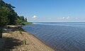
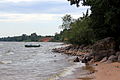
The banks of Lake Peipus have smooth contours and form only one large bay – Raskopelsky Bay. The low shores of the lake mostly consist of peat and are bordered by vast lowland and marshes, which are flooded in the spring with the flooding area reaching up to 1,000 km2 (390 sq mi). [7] There are sand dunes and hills covered with pine forests. Along the sandy shores, there is a 200–300 metres (660–980 ft) wide stretch of shallow waters. [8]

Water balance of Lake Peipus [7]
Water balanceVolume
InflowPrecipitation560 mm (1.9 km3)
Surface and groundwater 3150 mm (11.2 km3)
Outflow Streamflow 3390 mm (12 km3)
Evaporation 320 mm (1.1 km3)

The relief of the bottom is uniform and flat, gradually rising near the shores and covered with silt, and in some places with sand. [9] The deepest point of 15.3 metres (50 ft) is located in the Teploe Lake, 300 metres (980 ft) from the coast. [10]

The lake is well-flowing, with the annual inflow of water equal to about half of the total water volume. [7]

The lake water is fresh, with a low transparency of about 2.5 metres (8 ft 2 in) due to plankton and suspended sediments caused by the river flow. [7] Water currents are weak 5–9 cm/s (2.0–3.5 in/s); generally induced by wind, so stop when it ceases. However, during the spring flood, there is a constant surface current from north to south. [9]

Because of the shallow depth, the lake quickly warms and cools. Water temperature reaches 25–26 °C (77–79 °F) in July. [10] The lakes freeze in late November – early December and thaw in late April – early May, first lakes Teploe and Pihkva and then lake Peipus. However, due to recent climatic changes, Lake Peipus has now commonly started to freeze later into December and thaw much earlier in April. [7]

Lake Peipus, Estonia.jpg
Peipus Kallaste 3.JPG
LakePeipus01.JPG
Shoreline, south of Mustvee Kallaste Mustvee harbour
Map of pools of Narva and Lake Peipsi Narva basin map.svg
Map of pools of Narva and Lake Peipsi

Basin and islands

About 30 rivers flow into the lake. [11] The largest are Velikaya and Emajõgi; smaller rivers include Zadubka, Cherma, Gdovka, Kuna, Torokhovka, Remda, Rovya, Zhelcha, Chernaya, Lipenka, Startseva, Borovka, Abija, Obdeh, Piusa, Võhandu, Kodza, Kargaya, Omedu, Tagajõgi and Alajõgi. The lake is drained by only one river, the Narva, into the Baltic Sea. [4]

The lake contains 29 islands, with a total area of 25.8 km2, with 40 more islands located within the delta of the Velikaya River. [10] The islands are low wetlands, elevated above the lake surface on average by only 1–2 metres (3 ft 3 in – 6 ft 7 in) (maximum 4.5 metres (15 ft)) and therefore suffer from floods. The largest islands are Piirissaar (area 7.39 km2 (2.85 sq mi), located in the southern part of Lake Peipus), Kolpina (area 11 km2, in the Pihkva Lake) and Kamenka (area 6 km2). In the center of Pihkva Lake there is a group of Talabski Islands (Talabsk, Talabenets and Verkhniy). [12]

Flora and fauna

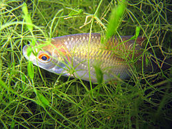
The lake hosts 54 species of coastal aquatic flora, including cane, calamus (Acorus calamus), bulrush, grass rush, lesser bulrush (Typha angustifolia) and water parsnip (Sium latifolium). Floating plants are rare and are of only three types: arrowhead, yellow water-lily and water knotweed. [13] The lake is home to perch, pike-perch, bream, roaches, whitefishes, smelt and other species of fish. [4] The wetlands of the coastal strip of the lake are important resting and feeding grounds for swans, geese and ducks migrating between the White Sea and Baltic Sea and western Europe. [9] [14] Lake Peipsi is one of the main stopovers for Bewick's swan (Cygnus columbianus). The swans leave their breeding grounds in the Russian Arctic 1,600 kilometres (990 mi) away and the lake is the first stop for many. Bewick's rarely fly more than 1,900 kilometres (1,200 mi) without fueling so they are near to the limits of their endurance when they reach the lake. [15]

Ecology

The ecological condition of the lake basin is, in general, satisfactory – water is mostly of grades I and II (clean), and is of grade III in some rivers due to the high content of phosphorus. The water condition of the rivers has improved since 2001–2007, but there is an increase in population of blue-green algae. The main problem of Lake Peipus is its eutrophication. [16]

Economy

The towns standing on the banks are relatively small and include Mustvee (population 1,610), Kallaste (population 1,260) and Gdov (population 4,400). The largest city, Pskov (population 202,000) stands on the river Velikaya, 10 kilometres (6.2 mi) from the lake. [8] Ship navigation is well developed and serves fishery, transport of goods and passengers and tourist tours. [14] [17] [18] The picturesque shores of the lake are a popular destination for tourism and recreation at several tourist camps and sanatoriums. [19] [20] [21]

History

In 1242, the southern part of Lake Peipus hosted a major historical battle where Teutonic Knights were defeated by Novgorod troops led by Alexander Nevsky. The battle is remarkable in that it was mostly fought on the frozen surface of the lake and is therefore called the Battle on the Ice. [22] [23]

The largest city on the lake, Pskov, is also one of the oldest cities in Russia, known from at least 903 AD from a record in the Primary Chronicle of the Laurentian Codex. [24] [25] The city had a certain measure of independence even though it was dominated by its neighbours - Novgorod, Lithuania and Muscovy - and eventually incorporated in the Russian state. Several historical buildings remain in the city, including Mirozhsky Monastery (1156, which contains famous frescoes of 14–17th centuries), Pskov Kremlin (14–17th centuries) with the five-domed Trinity Cathedral (1682–1699), churches of Ivanovo (until 1243), Snetogorsky Monastery (13th century), Church of Basil (1413), Church of Cosmas and Damian (1462), Church of St. George (1494) and others. [26]

Gdov was founded in 1431 as a fortress and became a city in 1780; [27] the only remains of the historical Gdov Kremlin are three fortress walls. [28] Kallaste was founded in the 18th century by the Old Believers who had fled from the Novgorod area, [29] [30] and there is still a functional Russian Orthodox Old-Rite Church in the town. Near Kallaste, there is one of the largest surfacings of Devonian sandstone with a length of 930 metres (3,050 ft) and a maximum height of 8 metres (26 ft), as well as several caves and one of the largest colonies of swallows in Estonia. [31]

Notes

  1. Estonian: Peipsi järv; lang-ru, lit. 'Chudsko-Pskovskoye ozero, Pskovsko-Chudskoye ozero'

Related Research Articles

<span class="mw-page-title-main">Geography of Estonia</span> Overview of the geography of Estonia

Between 57.3 and 59.5 latitude and 21.5 and 28.1 longitude, Estonia lies on the eastern coast of the Baltic Sea on the level northwestern part of the rising East European Platform. Estonia's continental mainland is bordered to the north by the Gulf of Finland across from Finland, to the east by Lake Peipus and Russia, and to the south by Latvia. Besides the part of the European continent, Estonian territory also includes the larger islands of Saaremaa and Hiiumaa, and over 2,200 other islands and islets in the Baltic Sea, off the western and northern shores of the country's mainland.

<span class="mw-page-title-main">Lake Onega</span> Freshwater lake in Russia, second largest in Europe

Lake Onega is a lake in northwestern Russia, on the territory of the Republic of Karelia, Leningrad Oblast and Vologda Oblast. It belongs to the basin of the Baltic Sea, and is the second-largest lake in Europe after Lake Ladoga, slightly smaller than Lebanon. The lake is fed by about 50 rivers and is drained by the Svir.

<span class="mw-page-title-main">Pskov Oblast</span> First-level administrative division of Russia

Pskov Oblast is a federal subject of Russia, located in the west of the country. Its administrative center is the city of Pskov. As of the 2021 Census, its population was 599,084.

<span class="mw-page-title-main">Narva (river)</span> River between Estonia and Russia

The river Narva, formerly also Narwa or Narova, flows 77 kilometres (48 mi) north into the Baltic Sea and is the largest Estonian river by discharge. A similar length of land far to the south, together with it and a much longer intermediate lake, Lake Peipus, all together nowadays form the international border between Estonia and Russia.

<span class="mw-page-title-main">Gdov</span> Town in Pskov Oblast, Russia

Gdov is a town and the administrative center of Gdovsky District in Pskov Oblast, Russia, located on the river Gdovka, just 2 kilometers (1.2 mi) from its outflow into Lake Peipus. Population: 3,465 (2021 Census); 4,379 (2010 Census); 5,171 (2002 Census); 6,009 (1989 Census).

<span class="mw-page-title-main">Battle on the Ice</span> 1242 battle of the Northern Crusades on the frozen Lake Peipus

The Battle on the Ice, alternatively known as the Battle of Lake Peipus, took place on 5 April 1242. It was fought largely on the frozen Lake Peipus between the united forces of the Republic of Novgorod and Vladimir-Suzdal, led by Prince Alexander Nevsky, and the forces of the Livonian Order and Bishopric of Dorpat, led by Bishop Hermann of Dorpat.

<span class="mw-page-title-main">Velikaya</span> River in Russia

The Velikaya is a river in Novosokolnichesky, Pustoshkinsky, Sebezhsky, Opochetsky, Pushkinogorsky, Ostrovsky, Palkinsky, and Pskovsky Districts of Pskov Oblast, as well as in the city of Pskov in Russia. It is the largest tributary of Lake Peipus and belongs to the drainage basin of the Narva. It is 430 kilometres (270 mi) long, and the area of its basin 25,200 square kilometres (9,700 sq mi). The name of the river literally means "Grand" or "Great" in Russian. The towns of Opochka, Ostrov and Pskov are located on the banks of the Velikaya. The principal tributaries of the Velikaya are the Alolya (right), the Issa (left), the Sorot (right), the Sinyaya (left), the Utroya (left), the Kukhva (left), the Cheryokha (right), and the Pskova (right).

<span class="mw-page-title-main">Emajõgi</span> River in Estonia

Emajõgi is a river in Estonia which flows from Lake Võrtsjärv through Tartu County into Lake Peipsi, crossing the city of Tartu for 10 km. It has a length of 100 km.

The Sudoma is a left tributary of the Shelon, with its course located in Sudoma uplands in Dedovichsky and Bezhanitsky District of Pskov Oblast of Russia. The Sudoma is part of the Lake Ilmen drainage basin. The river has a length of 65 kilometres (40 mi) and drains a basin of 480 square kilometres (190 sq mi). It rarely attains the width of 20 metres (66 ft), being no deeper than 1 metre (3.3 ft) along its course. It notably flows through Sosonskaya Volost where a synonymous village also exists.

<span class="mw-page-title-main">Kauksi, Ida-Viru County</span> Village in Estonia

Kauksi is a small village in Alutaguse Parish, Ida-Viru County in northeastern Estonia. Kauksi has 59 inhabitants. It lies on the northern side of Estonia's largest lake, Peipus.

<span class="mw-page-title-main">Gdovsky District</span> District in Pskov Oblast, Russia

Gdovsky District is an administrative and municipal district (raion), one of the twenty-four in Pskov Oblast, Russia. It is located in the northwest of the oblast and borders with Slantsevsky District of Leningrad Oblast in the north, Plyussky District in the east, Strugo-Krasnensky District in the southeast, and with Pskovsky District in the south. Lake Peipus forms the border with Estonia in the west. The area of the district is 3,400 square kilometers (1,300 sq mi). Its administrative center is the town of Gdov. Population: 12,792 (2010 Census); 17,715 ; 19,842 (1989 Census). The population of Gdov accounts for 34.2% of the district's total population.

<span class="mw-page-title-main">Pechorsky District</span> District in Pskov Oblast, Russia

Pechorsky District is an administrative and municipal district (raion), one of the twenty-four in Pskov Oblast, Russia. It is located in the northwest of the oblast and borders with Pskovsky District in the northwest, Palkinsky District in the southeast, Alūksne municipality of Latvia in the southwest, and with Võru and Põlva Counties of Estonia in the northwest. Lake Peipus limits the district from the north. The area of the district is 1,251 square kilometers (483 sq mi). Its administrative center is the town of Pechory. Population: 22,123 (2010 Census); 25,300 ; 27,199 (1989 Census). The population of Pechory accounts for 50.6% of the district's total population.

<span class="mw-page-title-main">Pskovsky District</span> District in Pskov Oblast, Russia

Pskovsky District is an administrative and municipal district (raion), one of the twenty-four in Pskov Oblast, Russia. It is located in the northwest of the oblast and borders with Gdovsky District in the north, Strugo-Krasnensky District in the northeast, Porkhovsky District in the east, Ostrovsky District in the south, and with Palkinsky and Pechorsky Districts in the southwest. Lake Peipus forms the border with Estonia in the west. The area of the district is 3,600 square kilometers (1,400 sq mi). Its administrative center is the city of Pskov. Population: 34,323 (2010 Census); 37,216 ; 37,557 (1989 Census).

<span class="mw-page-title-main">Strugo-Krasnensky District</span> District in Pskov Oblast, Russia

Strugo-Krasnensky District is an administrative and municipal district (raion), one of the twenty-four in Pskov Oblast, Russia. It is located in the northeast of the oblast and borders with Plyussky District in the north, Shimsky and Soletsky Districts of Novgorod Oblast in the east, Porkhovsky District in the south, Pskovsky District in the west, and with Gdovsky District in the northwest. The area of the district is 3,090.1 square kilometers (1,193.1 sq mi). Its administrative center is the urban locality of Strugi Krasnye. Population: 13,466 (2010 Census); 16,579 ; 16,293 (1989 Census). The population of Strugi Krasnye accounts for 62.7% of the district's total population.

<span class="mw-page-title-main">Gdovka</span> River in Russia

The Gdovka is a river in Gdovsky District of Pskov Oblast, Russia. The source of the river is the Pyosy Mokh swamp. The Gdovka is a tributary of Lake Peipus. It is 23 kilometres (14 mi) long and has a drainage basin of the area of 150 square kilometres (58 sq mi). The town of Gdov and the village of Ustye are located on the banks of the Gdovka.

Remdovsky Zakaznik is a federal zakaznik, a nature protected area, in the northwest of Russia, located in Gdovsky and Pskovsky Districts of Pskov Oblast, north of the city of Pskov. It was established in 1985 to protect flora and fauna of the lowlands adjacent to Lake Peipus.

<span class="mw-page-title-main">Lake Zhizhitskoye</span>

Lake Zhizhitskoye is a freshwater lake, located in Kunyinsky District of Pskov Oblast in Russia. It is the second biggest lake in Pskov Oblast after Lake Peipus. The area of the lake is 51.3 square kilometres (19.8 sq mi). Lake Undozero is the source of the Zhizhitsa River, a right tributary of the Western Dvina River, and thus belongs to the Baltic Sea basin.

<span class="mw-page-title-main">Estonia–Russia border</span> International border

The Estonia–Russia border is the international border between the Republic of Estonia and the Russian Federation. The border is 294 kilometres (183 mi) long. It emerged during World War I, in 1918, as Estonia declared its independence from the then warring Russian and German Empires. The border goes mostly along the national, administrative and ethnic boundaries that have gradually formed since the 13th century. The exact location of the border was a subject of Estonian–Russian dispute that was resolved with the signing of the Border Agreement, but neither Russia nor Estonia have completed its ratification yet. It is an external border of the European Union.

Lake Peipus dialect is a Russian language variety spoken on both sides of the Lake Peipus in Pskov Oblast, Russia and some counties of Estonia. It originated as a mix of Pskov and Gdov dialects of the Central Russian cluster. As many other dialects from this area, it is often considered to be transitional between Russian and Belarusian. Lake Peipus dialects also include some loanwords from the Estonian language.

<span class="mw-page-title-main">Khummi</span> Lake of Khabarovsk Krai

Lake Khummi, also known as Khomi (Хоми), is a large freshwater lake in Komsomolsky District, Khabarovsk Krai, Russia. It has an area of 117 km2 (45 sq mi) and a maximum depth of 3.9 m (13 ft). The lake is part of the Amur river basin and lies near Komsomolsk-on-Amur, 32 km (20 mi) to the southeast of the city. The village of Selikhino, as well as a tourist resort, are located by the lakeshore.

References

  1. Lake Peipus. Encyclopædia Britannica online
  2. Lake Peipus. Encyclopædia Britannica online
  3. The whispering waters of Estonia – Visit Estonia
  4. 1 2 3 Чудско-Псковское озеро, Great Soviet Encyclopedia
  5. (in Russian) Russian lakes with area of more than 350 km². (GIF table). Retrieved on 2012-01-21.
  6. Encyclopedic Dictionary of Geography: Geographical names – Moscow: Soviet Encyclopedia. 1983, p. 488.
  7. 1 2 3 4 5 Sokolov AA Hydrography of the USSR L.: Gidrometeoizdat, 1952
  8. 1 2 Tourist Encyclopedia. Peipsi-Pskov Lake. Outdoors.ru. Retrieved on 2012-01-21.
  9. 1 2 3 study the situation of the ports on the Narva River Archived 2016-03-03 at the Wayback Machine . Arhiv.ivangorod.ru. Retrieved on 2012-01-21.
  10. 1 2 3 lakes and rivers south of Estonia, the islands [ dead link ]
  11. By Peipus pond Archived 2016-03-04 at the Wayback Machine . Zachetka.ru. Retrieved on 2012-01-21.
  12. "Публичная кадастровая карта". pkk5.rosreestr.ru. Retrieved 2018-01-08.[ permanent dead link ]
  13. Fish and Lake Pskov region. Lakes. Pskovfish.ru. Retrieved on 19 February 2017.
  14. 1 2 Tourist portal. Svali.ru (2008-01-28). Retrieved on 2012-01-21.
  15. Newth, Julia (November 2016). "Race against time". BBC Wildlife. 34 (12): 40–6.
  16. Minutes of the eleventh meeting of the Joint Russian-Estonian commission for the protection and rational use of transboundary waters [ dead link ]
  17. TrevelTurs. Peipsi-Pskov lake system Archived 2016-03-04 at the Wayback Machine . Traveltours.ru. Retrieved on 2012-01-21.
  18. Transport of Pskov Oblast. All-transport.info. Retrieved on 2012-01-21.
  19. Pskov region. Peipsi and Lake Pskov Archived 2018-02-05 at the Wayback Machine . noveltour.ru
  20. More and more foreigners resting on Lake Peipus. Megatis.ru (2002-08-08). Retrieved on 2012-01-21.
  21. Tourist Encyclopedia. Vladsc.narod.ru. Retrieved on 2012-01-21.
  22. Tony Jaques (2007). Dictionary of Battles and Sieges: F-O. Greenwood Publishing Group. p. 564. ISBN   0-313-33538-9.
  23. Toivo Miljan (2004). Historical dictionary of Estonia. Scarecrow Press. p. 299. ISBN   0-8108-4904-6.
  24. Псков, Great Soviet Encyclopedia
  25. Wladyslaw Duczko (2004). Viking Rus: studies on the presence of Scandinavians in Eastern Europe. BRILL. p. 114. ISBN   90-04-13874-9.
  26. ancient city of Pskov. Old-pskov.ru. Retrieved on 2012-01-21.
  27. Гдов, Great Soviet Encyclopedia
  28. My Gdov Archived 2016-03-03 at the Wayback Machine . mygdov.ru (in Russian)
  29. Kallaste. A bit of history. Moles.ee (2000-06-28). Retrieved on 2012-01-21.
  30. Old Believer community Kallaste. Starover.ee. Retrieved on 2012-01-21.
  31. Russian site about the city Kallaste. Kallaste.ucoz.org (2012-01-04). Retrieved on 2012-01-21.