| Designations | |
|---|---|
| Official name | Blekinge skärgård |
| Designated | 14 November 2001 |
| Reference no. | 1115 [1] |

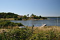
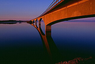
Blekinge archipelago is an archipelago in the Baltic Sea, located in Blekinge in the south of Sweden.
| Designations | |
|---|---|
| Official name | Blekinge skärgård |
| Designated | 14 November 2001 |
| Reference no. | 1115 [1] |
Blekinge archipelago is an archipelago in the Baltic Sea, located in Blekinge in the south of Sweden.
Blekinge archipelago stretches among almost the entire coastline of Blekinge, from west to east. It covers some 210,000 hectares (520,000 acres) including water; the landmass amounts to about 54,000 hectares (130,000 acres). The archipelago is dominated by a few large islands, Tjärö, Aspö, Hasslö, Tärnö and Sturkö, with smaller islands and skerries interspersed. In the whole archipelago area, some 85,000 people live, of whom 4,000 are islanders. [2] The island of Utlängan is the farthest out to sea of the archipelago's islands; only the lighthouse rock Utklippan is farther out.
The landscape is a diverse cultural landscape, characterised by mainly a mix between oak pastures and deciduous forest. For its size, the archipelago exhibits an unusually high biodiversity. Endangered species who find a habitat in the archipelago include Osmoderma eremita and Lecanographa amylacea. [2]
The towns of Karlshamn and Karlskrona are both located within the archipelago area; indeed, Karlskrona is mainly situated on Trossö island. The latter, having been founded as a naval base, is noted for its Baroque architecture and listed as a UNESCO World Heritage Site.
Shipbuilding has been a traditional local trade within the archipelago and the area is known for a traditional type of small boat, called blekingeeka and used for tasks like fishing and transporting stone locally. [3]
In the 1970s, the local diving club discovered a shipwreck in the Blekinge archipelago that was eventually identified by archaeologists as Gribshunden , a 15th-century Danish warship. [4] [5] The shipwreck is significant as one of the best-preserved wreckages from the early modern period. [4] [6]
Tjärö island was the site of the Sweden Social Web Camp from 2009 to 2013. [7]


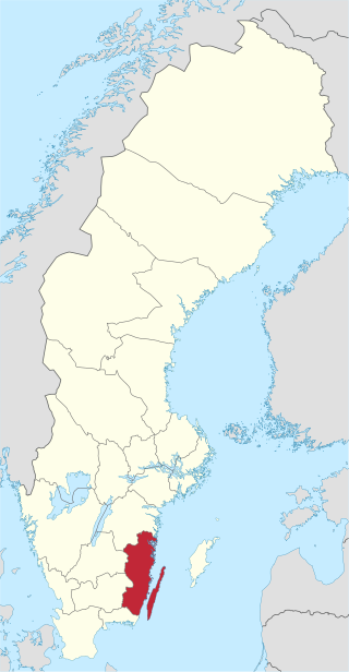
Blekinge County is a county or län in the south of Sweden. It borders the Counties of Skåne, Kronoberg, Kalmar and the Baltic Sea. The capital is Karlskrona. It is the smallest of the present administrative counties of Sweden, covering only 0,7% of the total area of the country. Princess Adrienne, the daughter of Princess Madeleine, is Duchess of Blekinge.
Kalmar County is a county or län in southern Sweden. It borders the counties of Kronoberg, Jönköping, Blekinge and Östergötland. To the east in the Baltic Sea is the island Gotland.

Götaland is one of three lands of Sweden and comprises ten provinces. Geographically it is located in the south of Sweden, bounded to the north by Svealand, with the deep woods of Tiveden, Tylöskog and Kolmården marking the border.
The Blekinge Institute of Technology is a public, state funded Swedish institute of technology in Blekinge with 5,900 students and offers about 30 educational programmes in 11 departments at two campuses located in Karlskrona and Karlshamn.

Ronneby is a locality and the seat of Ronneby Municipality in Blekinge County, Sweden with 12,029 inhabitants in 2010.
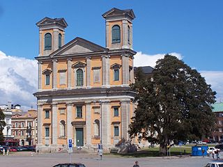
Karlskrona is a locality and the seat of Karlskrona Municipality, Blekinge County, Sweden with a population of 66,675 in 2018. It is also the capital of Blekinge County. Karlskrona is known as Sweden's only baroque city and is host to Sweden's largest naval base and the headquarters of the Swedish Coast Guard.

The Bothnian Bay or Bay of Bothnia is the northernmost part of the Gulf of Bothnia, which is in turn the northern part of the Baltic Sea. The land holding the bay is still rising after the weight of ice-age glaciers has been removed, and within 2,000 years the bay will be a large freshwater lake since its link to the south Kvarken is mostly less than 20 metres (66 ft) deep. The bay today is fed by several large rivers, and is relatively unaffected by tides, so has low salinity. It freezes over each year for up to six months. Compared to other parts of the Baltic, it has little plant or animal life.
Replot is an island in the Kvarken, the narrowest part of the Gulf of Bothnia in the northern part of the Baltic Sea. It has about 2,100 inhabitants, almost only Swedish-speaking. The size is about 150 square kilometres (58 sq mi), one of the largest islands of Finland. Replot was an independent municipality until 1973, when it was consolidated to the municipality of Korsholm, near Vaasa.
Southern Military District, originally I Military District was a Swedish military district, a command of the Swedish Armed Forces that had operational control over Southern Sweden, for most time of its existence corresponding to the area covered by the counties of Malmöhus, Kristianstad, Blekinge, Kronoberg, Jönköping and Kalmar. The headquarters of Milo S were located in Kristianstad.
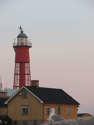
Utklippan is a Swedish island group including Södraskär, Norraskär, and Degerhuvudet. It has been home to a lighthouse since 1789.
Utlängan is an island in the Karlskrona archipelago in Blekinge, Sweden.
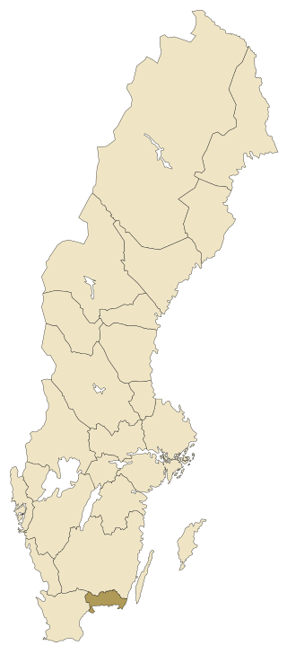
Blekinge is one of the traditional Swedish provinces, situated in the southern coast of the geographic region of Götaland, in southern Sweden. It borders Småland, Scania and the Baltic Sea. It is the country's second-smallest province by area, and the smallest province located on the mainland.

The Karlskrona naval base is the largest naval base of the Swedish Navy. Located in Blekinge in southern Sweden, the base has close ties with the city of Karlskrona. It has an exceptionally well-sheltered location: arcs of islands provide a strong defense not only from the sea but also from land attacks. Two of Sweden's three naval warfare flotillas are based there. It contains the Marinmuseum and the Ropewalk, the longest wooden building in the country.
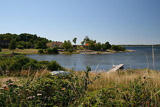
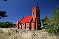
Aspö is an island in the Blekinge archipelago of southeast Sweden. It constitutes a parish in Medelstad Hundred, Karlskrona Municipality, Blekinge County. It contains the settlement of Drottningskär and a 17th-century naval citadel of the same name. The island has about 460 permanent residents, with many more visitors staying in summer. A ferry for vehicles and passengers runs hourly, free of charge, between Aspö and Karlskrona.

Granskär is an island in the Kvarken, the narrowest part of the Gulf of Bothnia in the northern part of the Baltic Sea. It has few inhabitants, almost all Swedish-speaking. Granskär belongs to the municipality of Vaasa.
Sweden Social Web Camp (SSWC) was a Swedish user-generated conference held on the island of Tjärö, Karlshamn Municipality, active between 2009 and 2013. The event focussed on internet and web technology and use in the context of social media. The format was open, participatory workshop-events, the content of which is provided by the participants. As anyone could decide to run a workshop during the event other, non-social web, subjects have of course turned up on the unconference grid.
Värnanäs archipelago is a nature reserve and Natura 2000 designated area situated in south-eastern Sweden, in Kalmar County.
The Norrbotten archipelago is a group of Swedish islands in the north part of the Bay of Bothnia. A few of the islands have small permanent populations, but most are used only for recreation in the summer months. They are icebound during the winter.
The Haparanda archipelago is a group of 792 Swedish islands in the north part of the Bay of Bothnia. The islands are used for recreation in the summer months. They are icebound during the winter.
Gribshunden or Griffen, also known by several variant names including Gribshund, Gripshunden, Gripshund, Griff, and Griffone, was a Danish warship, the flagship of Hans (John), King of Denmark. Gribshunden sank in 1495 after an explosion while in the Baltic Sea off the coast of Ronneby in southeastern Sweden; the ship is one of the best-preserved wrecks yet discovered from the late medieval period.