Amundsen Sea

Last updated
The Amundsen Sea area of Antarctica AmundsenSea.jpg
The Amundsen Sea area of Antarctica
Antarctic iceberg floating in the Amundsen Sea water, October 2009. Antarctic Sea Ice - Amundsen Sea.jpg
Antarctic iceberg floating in the Amundsen Sea water, October 2009.

The Amundsen Sea is an arm of the Southern Ocean off Marie Byrd Land in western Antarctica. It lies between Cape Flying Fish (the northwestern tip of Thurston Island) to the east and Cape Dart on Siple Island to the west. Cape Flying Fish marks the boundary between the Amundsen Sea and the Bellingshausen Sea. West of Cape Dart there is no named marginal sea of the Southern Ocean between the Amundsen and Ross Seas. The Norwegian expedition of 1928–1929 under Captain Nils Larsen named the body of water for the Norwegian polar explorer Roald Amundsen while exploring this area in February 1929. [1]

Contents

The sea is mostly ice-covered, and the Thwaites Ice Tongue protrudes into it. The ice sheet which drains into the Amundsen Sea averages about 3 km (1.9 mi) in thickness; roughly the size of the state of Texas, this area is known as the Amundsen Sea Embayment (ASE); it forms one of the three major ice-drainage basins of the West Antarctic Ice Sheet.

Embayment

Large B-22 iceberg breaking off from Thwaites Glacier and remnants of the B-21 iceberg from Pine Island Glacier in Pine Island Bay to the right of the image Amundsen Sea Icebergs.jpg
Large B-22 iceberg breaking off from Thwaites Glacier and remnants of the B-21 iceberg from Pine Island Glacier in Pine Island Bay to the right of the image

The ice sheet that drains into the Amundsen Sea averages about 3 km (1.9 mi) in thickness. It is roughly the size of the state of Texas and is known as the Amundsen Sea Embayment (ASE); it forms one of the three major ice drainage basins of the West Antarctic Ice Sheet along with the Ross Sea Embayment and the Weddell Sea Embayment.

Some scientists proposed that this region may be a weak underbelly of the West Antarctic Ice Sheet. The Pine Island and Thwaites Glaciers, which both flow into the Amundsen Sea, are two of Antarctica's largest five. Researchers reported that the flow of these glaciers increased starting in the mid-2000s; if they were to melt completely, global sea levels would rise by about 0.9–1.9 meters (3.0–6.2 feet). Other researchers suggested that the loss of these glaciers would destabilise the entire West Antarctic ice sheet and possibly sections of the East Antarctic Ice Sheet. [2]

A 2004 study suggested that because the ice in the Amundsen Sea had been melting rapidly and was riven with cracks, the offshore ice shelf was set to collapse "within five years". The study projected a sea level rise of 1.3 m (4.3 ft) from the West Antarctic Ice Sheet if all the sea ice in the Amundsen Sea melted. [3]

Measurements made by the British Antarctic Survey in 2005 showed that the ice discharge rate into the Amundsen Sea embayment was about 250 km3 per year. Assuming a steady rate of discharge, this alone was sufficient to raise global sea levels by 0.2 mm per year. [4]

A subglacial volcano was detected just north of the Pine Island Glacier near the Hudson Mountains. It last erupted approximately 2,200 years ago, indicated by widespread ash deposits within the ice, in what was the largest known eruption in Antarctica within the prior 10 millennia. [5] [6] Volcanic activity may be contributing to the observed increase of glacial flow, [7] although the most popular theory is that the flow has increased due to warming ocean water. [8] [9] This water has warmed due to an upwelling of deep ocean water due to variations in pressure systems, which could have been affected by global warming. [10]

Amundsen Sea as part of the Southern Ocean Antarctic-seas-en.svg
Amundsen Sea as part of the Southern Ocean

In January 2010, a modelling study suggested that the "tipping point" for Pine Island Glacier may have been passed in 1996, with a retreat of 200 kilometers (120 miles) possible by 2100, producing a corresponding 24 cm (0.79 ft) of sea level rise. It was suggested that these estimates were conservative. [11] The modelling study also stated that "Given the complex, three-dimensional nature of the real Pine Island glacier ... it should be clear that the [...] model is a very crude representation of reality." [12]

A 2023 study estimated that the area lost 3.3 trillion tons of ice between 1996 and 2021, raising sea levels by 9 millimeters.

Pine Island Bay

Pine Island Bay ( 74°50′S102°40′W / 74.833°S 102.667°W / -74.833; -102.667 ) is a bay about 40 miles (64 km) long and 30 miles (48 km) wide, into which flows the ice of the Pine Island Glacier at the southeast extremity of the Amundsen Sea. It was delineated from aerial photographs taken by United States Navy (USN) Operation HIGHJUMP in December 1946, and named by the Advisory Committee on Antarctic Names for the USS Pine Island, seaplane tender and flagship of the eastern task group of USN Operation HIGHJUMP which explored this area. [13]

Russell Bay

Russell Bay ( 73°27′S123°54′W / 73.450°S 123.900°W / -73.450; -123.900 ) is a rather open bay in southwestern Amundsen Sea, extending along the north sides of Siple Island, Getz Ice Shelf and Carney Island, from Pranke Island to Cape Gates. It was mapped by the United States Geological Survey from surveys and USN air photos, 1959–66, and named by the Advisory Committee on Antarctic Names for Admiral James S. Russell, Vice Chief of Naval Operations during the post 1957–58 IGY period. [14]

Climate engineering

A proposed "underwater sill" blocking 50% of warm water flows heading for the glacier could have the potential to delay its collapse and the resultant sea level rise by many centuries. Wolovick2018 Thwaites sill timelines.png
A proposed "underwater sill" blocking 50% of warm water flows heading for the glacier could have the potential to delay its collapse and the resultant sea level rise by many centuries.

Some engineering interventions have been proposed for Thwaites Glacier and the nearby Pine Island Glacier to stabilize its ice physically, or to preserve it by blocking the flow of warm ocean water, which currently renders the collapse of these two glaciers practically inevitable even without further warming. [16] [17] A proposal from 2018 included building sills at the Thwaites' grounding line to either physically reinforce it, or to block some fraction of warm water flow. The former would be the simplest intervention, yet still equivalent to "the largest civil engineering projects that humanity has ever attempted": it is also only 30% likely to work. Constructions blocking even 50% of the warm water flow are expected to be far more effective, yet far more difficult as well. [15] Further, some researchers dissented, arguing that this proposal could be ineffective, or even accelerate sea level rise. [18] The original authors have suggested attempting this intervention on smaller sites, like the Jakobshavn Glacier in Greenland, as a test run, [15] [17] as well as acknowledging that this intervention cannot prevent sea level rise from the increased ocean heat content, and would be ineffective in the long run without greenhouse gas emission reductions. [15]

In 2023, a modified proposal was tabled: it was proposed that an installation of underwater "curtains", made out of a flexible material and anchored to Amundsen Sea floor would be able to interrupt warm water flow while reducing costs and increasing their longevity (conservatively estimated at 25 years for curtain elements and up to 100 years for the foundations) relative to more rigid structures. With them in place, Thwaites Ice Shelf and Pine Island Ice Shelf would presumably be able to regrow to a state they last had a century ago, thus stabilizing these glaciers. [19] [20] [17] To achieve this, the curtains would have to be placed at a depth of around 600 metres (0.37 miles) (to avoid damage from icebergs which would be regularly drifting above) and be 80 km (50 mi) long. The authors acknowledged that while work on this scale would be unprecedented and face many challenges in the Antarctic (including polar night and the currently insufficient numbers of specialized polar ships and underwater vessels), it would also not require any new technology and there is already experience of laying down pipelines at such depths. [19] [20]

Diagram of a proposed "curtain". Wolovick2023 Thwaites curtain.jpeg
Diagram of a proposed "curtain".
The authors estimated that this project would take a decade to construct, at $40–80 billion initial cost, while the ongoing maintenance would cost $1–2 billion a year. [19] [20] Yet, a single seawall capable of protecting the entire New York City may cost twice as much on its own, [17] and the global costs of adaptation to sea level rise caused by the glaciers' collapse are estimated to reach $40 billion annually: [19] [20] The authors also suggested that their proposal would be competitive with the other "climate engineering" proposals like stratospheric aerosol injection (SAI) or carbon dioxide removal (CDR), as while those would stop a much larger spectrum of climate change impacts, their estimated annual costs range from $7–70 billion for SAI to $160–4500 billion for CDR powerful enough to help meet the 1.5 °C (2.7 °F) Paris Agreement target. [19] [20]

Related Research Articles

<span class="mw-page-title-main">Ross Sea</span> Deep bay of the Southern Ocean in Antarctica

The Ross Sea is a deep bay of the Southern Ocean in Antarctica, between Victoria Land and Marie Byrd Land and within the Ross Embayment, and is the southernmost sea on Earth. It derives its name from the British explorer James Clark Ross who visited this area in 1841. To the west of the sea lies Ross Island and Victoria Land, to the east Roosevelt Island and Edward VII Peninsula in Marie Byrd Land, while the southernmost part is covered by the Ross Ice Shelf, and is about 200 miles (320 km) from the South Pole. Its boundaries and area have been defined by the New Zealand National Institute of Water and Atmospheric Research as having an area of 637,000 square kilometres (246,000 sq mi).

<span class="mw-page-title-main">Climate of Antarctica</span> Overview of climactic conditions in Antarctica

The climate of Antarctica is the coldest on Earth. The continent is also extremely dry, averaging 166 mm (6.5 in) of precipitation per year. Snow rarely melts on most parts of the continent, and, after being compressed, becomes the glacier ice that makes up the ice sheet. Weather fronts rarely penetrate far into the continent, because of the katabatic winds. Most of Antarctica has an ice-cap climate with extremely cold and dry weather.

<span class="mw-page-title-main">Ice shelf</span> Large floating platform of ice caused by glacier flowing onto ocean surface

An ice shelf is a large floating platform of ice that forms where a glacier or ice sheet flows down to a coastline and onto the ocean surface. Ice shelves are found in Antarctica and the Arctic. The boundary between the floating ice shelf and the anchor ice that feeds it is the grounding line. The thickness of ice shelves can range from about 100 m (330 ft) to 1,000 m (3,300 ft). The world's largest ice shelves are the Ross Ice Shelf and the Filchner-Ronne Ice Shelf in Antarctica. When a large piece of an ice shelf breaks off, this can lead to the formation of an iceberg. This process is also called ice calving.

<span class="mw-page-title-main">Transantarctic Mountains</span> Mountain range in Antarctica

The Transantarctic Mountains comprise a mountain range of uplifted rock in Antarctica which extends, with some interruptions, across the continent from Cape Adare in northern Victoria Land to Coats Land. These mountains divide East Antarctica and West Antarctica. They include a number of separately named mountain groups, which are often again subdivided into smaller ranges.

<span class="mw-page-title-main">West Antarctic Ice Sheet</span> Segment of the continental ice sheet that covers West (or Lesser) Antarctica

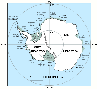
The West Antarctic Ice Sheet (WAIS) is the segment of the continental ice sheet that covers West Antarctica, the portion of Antarctica on the side of the Transantarctic Mountains that lies in the Western Hemisphere. It is classified as a marine-based ice sheet, meaning that its bed lies well below sea level and its edges flow into floating ice shelves. The WAIS is bounded by the Ross Ice Shelf, the Ronne Ice Shelf, and outlet glaciers that drain into the Amundsen Sea.

<span class="mw-page-title-main">Marie Byrd Land</span> Unclaimed West Antarctic region

Marie Byrd Land (MBL) is an unclaimed region of Antarctica. With an area of 1,610,000 km2 (620,000 sq mi), it is the largest unclaimed territory on Earth. It was named after the wife of American naval officer Richard E. Byrd, who explored the region in the early 20th century.

<span class="mw-page-title-main">Antarctic ice sheet</span> Earths southern polar ice cap

The Antarctic ice sheet is a continental glacier covering 98% of the Antarctic continent, with an area of 14 million square kilometres and an average thickness of over 2 kilometres (1.2 mi). It is the largest of Earth's two current ice sheets, containing 26.5 million cubic kilometres of ice, which is equivalent to 61% of all fresh water on Earth.

Smith Glacier is a low-gradient Antarctic glacier, over 160 km (100 mi) long, draining from Toney Mountain in an ENE direction to Amundsen Sea. A northern distributary, Kohler Glacier, drains to Dotson Ice Shelf but the main flow passes to the sea between Bear Peninsula and Mount Murphy, terminating at Crosson Ice Shelf.

<span class="mw-page-title-main">Pine Island Glacier</span> Large ice stream, fastest melting glacier in Antarctica

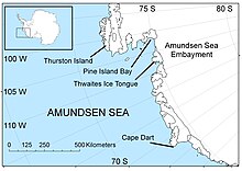
Pine Island Glacier (PIG) is a large ice stream, and the fastest melting glacier in Antarctica, responsible for about 25% of Antarctica's ice loss. The glacier ice streams flow west-northwest along the south side of the Hudson Mountains into Pine Island Bay, Amundsen Sea, Antarctica. It was mapped by the United States Geological Survey (USGS) from surveys and United States Navy (USN) air photos, 1960–66, and named by the Advisory Committee on Antarctic Names (US-ACAN) in association with Pine Island Bay.

<span class="mw-page-title-main">Thwaites Glacier</span> Antarctic glacier

Thwaites Glacier is an unusually broad and vast Antarctic glacier located east of Mount Murphy, on the Walgreen Coast of Marie Byrd Land. It was initially sighted by polar researchers in 1940, mapped in 1959–1966 and officially named in 1967, after the late American glaciologist Fredrik T. Thwaites. The glacier flows into Pine Island Bay, part of the Amundsen Sea, at surface speeds which exceed 2 kilometres (1.2 mi) per year near its grounding line. Its fastest-flowing grounded ice is centered between 50 and 100 kilometres east of Mount Murphy. Like many other parts of the cryosphere, it has been adversely affected by climate change, and provides one of the more notable examples of the retreat of glaciers since 1850.

<span class="mw-page-title-main">Ice stream</span> A region of fast-moving ice within an ice sheet

An ice stream is a region of fast-moving ice within an ice sheet. It is a type of glacier, a body of ice that moves under its own weight. They can move upwards of 1,000 metres (3,300 ft) a year, and can be up to 50 kilometres (31 mi) in width, and hundreds of kilometers in length. They tend to be about 2 km (1.2 mi) deep at the thickest, and constitute the majority of the ice that leaves the sheet. In Antarctica, the ice streams account for approximately 90% of the sheet's mass loss per year, and approximately 50% of the mass loss in Greenland.

<span class="mw-page-title-main">East Antarctic Ice Sheet</span> Segment of the continental ice sheet that covers East Antarctica

The East Antarctic Ice Sheet (EAIS) lies between 45° west and 168° east longitudinally. It was first formed around 34 million years ago, and it is the largest ice sheet on the entire planet, with far greater volume than the Greenland ice sheet or the West Antarctic Ice Sheet (WAIS), from which it is separated by the Transantarctic Mountains. The ice sheet is around 2.2 km (1.4 mi) thick on average and is 4,897 m (16,066 ft) at its thickest point. It is also home to the geographic South Pole, South Magnetic Pole and the Amundsen–Scott South Pole Station.

<span class="mw-page-title-main">Ice-sheet dynamics</span> Technical explanation of ice motion within large bodies of ice

Ice sheet dynamics describe the motion within large bodies of ice such as those currently on Greenland and Antarctica. Ice motion is dominated by the movement of glaciers, whose gravity-driven activity is controlled by two main variable factors: the temperature and the strength of their bases. A number of processes alter these two factors, resulting in cyclic surges of activity interspersed with longer periods of inactivity, on both hourly and centennial time scales. Ice-sheet dynamics are of interest in modelling future sea level rise.

<span class="mw-page-title-main">Sea level rise</span> Rise in sea levels due to climate change

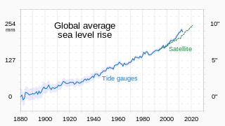
Between 1901 and 2018, average global sea level rose by 15–25 cm (6–10 in), an average of 1–2 mm per year. This rate accelerated to 4.62 mm/yr for the decade 2013–2022. Climate change due to human activities is the main cause. Between 1993 and 2018, thermal expansion of water accounted for 42% of sea level rise. Melting temperate glaciers accounted for 21%. Within this, Greenland accounted for 15% and Antarctica 8%. Sea level rise lags changes in the Earth's temperature. So sea level rise will continue to accelerate between now and 2050 in response to warming that is already happening. What happens after that depends on human greenhouse gas emissions. Sea level rise may slow down between 2050 and 2100 if there are deep cuts in emissions. It could then reach a little over 30 cm (1 ft) from now by 2100. With high emissions it may accelerate. It could rise by 1 m or even 2 m by then. In the long run, sea level rise would amount to 2–3 m (7–10 ft) over the next 2000 years if warming amounts to 1.5 °C (2.7 °F). It would be 19–22 metres (62–72 ft) if warming peaks at 5 °C (9.0 °F).

<span class="mw-page-title-main">Eric Rignot</span> American scientist

Eric J. Rignot is the Donald Bren, Distinguished and Chancellor Professor of Earth system science at the University of California, Irvine, and a Senior Research Scientist for the Radar Science and Engineering Section at NASA's Jet Propulsion Laboratory. He studies the interaction of the polar ice sheets in Greenland and Antarctica with global climate using a combination of satellite remote sensing, airborne remote sensing, understanding of physical processes controlling glacier flow and ice melt in the ocean, field methods, and climate modeling. He was elected at the National_Academy_of_Sciences in 2018.

<span class="mw-page-title-main">Climate change in Antarctica</span> Impacts of climate change on Antarctica

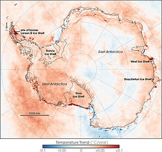
Climate change caused by greenhouse gas emissions from human activities occurs everywhere on Earth, and while Antarctica is less vulnerable to it than any other continent, climate change in Antarctica has already been observed. There has been an average temperature increase of >0.05 °C/decade since 1957 across the continent, although it had been uneven. While West Antarctica warmed by over 0.1 °C/decade from the 1950s to the 2000s and the exposed Antarctic Peninsula has warmed by 3 °C (5.4 °F) since the mid-20th century, the colder and more stable East Antarctica had been experiencing cooling until the 2000s. Around Antarctica, the Southern Ocean has absorbed more heat than any other ocean, with particularly strong warming at depths below 2,000 m (6,600 ft) and around the West Antarctic, which has warmed by 1 °C (1.8 °F) since 1955.

<span class="mw-page-title-main">Marine ice sheet instability</span>

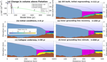
Marine ice sheet instability (MISI) describes the potential for ice sheets grounded below sea level to destabilize in a runaway fashion. The mechanism was first proposed in the 1970s by Johannes Weertman and was quickly identified as a means by which even gradual anthropogenic warming could lead to relatively rapid sea level rise. In Antarctica, the West Antarctic Ice Sheet, the Aurora Subglacial Basin, and the Wilkes Basin are each grounded below sea level and are inherently subject to MISI.

<span class="mw-page-title-main">Thwaites Ice Shelf</span> Antarctic ice shelf in the Amundsen Sea

Thwaites Ice Shelf, is an Antarctic ice shelf in the Amundsen Sea. It was named by ACAN after Fredrik T. Thwaites, a glacial geologist and geomorphologist. The Thwaites Ice Shelf is one of the biggest ice shelves in West Antarctica, though it is highly unstable and disintegrating rapidly. Since the 1980s, the Thwaites glacier, nicknamed the "Doomsday glacier", has had a net loss of over 600 billion tons of ice, though pinning of the Thwaites Ice Shelf has served to slow the process. The Thwaites Ice Shelf has acted like a dam for the eastern portion of glacier, bracing it and allowing for a slow melt rate, in contrast to the undefended western portion.

Kirsteen Jane Tinto is a glaciologist known for her research on the behavior and subglacial geology of the Greenland and Antarctic ice sheets.

An ice shelf basal channel is a type of subglacial meltwater channel that forms on the underside of floating ice shelves connected to ice sheets. Basal channels are generally rounded cavities which form parallel to ice sheet flow. These channels are found mainly around the Greenland and Antarctic ice sheets in places with relatively warm ocean water. West Antarctica in particular has the highest density of basal channels in the world. Basal channels can be tens of kilometers long, kilometers wide, and incise hundreds of meters up into an ice shelf. These channels can evolve and grow just as rapidly as ice shelves can, with some channels having incision rates approaching 22 meters per year. Basal channels are categorized based on what mechanisms created them and where they formed.

References

  1. "Amundsen Sea". Geographic Names Information System . United States Geological Survey . Retrieved 23 October 2011.
  2. Pearce, Fred (2007). With Speed and Violence: Why scientists fear tipping points in climate change . Beacon Press Books. ISBN   978-0-8070-8576-9.
  3. Flannery, Tim F. (2006). The Weather Makers: How man is changing the climate and what it means for life on Earth. HarperCollins. pp.  356. ISBN   978-0-00-200751-1.
  4. Strom, Robert (2007). "The Melting Earth". Hot House: Global Climate Change and the Human Condition. Coprenicus Books. p. 302.
  5. Black, Richard (20 January 2008). "Ancient Antarctic eruption noted". BBC News . London: BBC . Retrieved 22 October 2011.
  6. Corr, H. F. J.; Vaughan, D. G. (2008). "A recent volcanic eruption beneath the West Antarctic ice sheet". Nature Geoscience . 1 (2): 122–125. Bibcode:2008NatGe...1..122C. doi:10.1038/ngeo106.
  7. Mosher, Dave (20 January 2008). "Buried Volcano Discovered in Antarctica". Imaginova Corp. LiveScience.com. Retrieved 11 April 2009.
  8. Payne, A. J.; Vieli, A.; Shepherd, A. P.; Wingham, D. J.; Rignot, E. (2004). "Recent dramatic thinning of largest West Antarctic ice stream triggered by oceans". Geophysical Research Letters . 31 (23): L23401. Bibcode:2004GeoRL..3123401P. CiteSeerX   10.1.1.1001.6901 . doi:10.1029/2004GL021284. S2CID   4891690.
  9. Shepherd, A. P.; Wingham, D. J.; Rignot, E. (2004). "Warm ocean is eroding West Antarctic Ice Sheet" (PDF). Geophysical Research Letters . 31 (23): L23402. Bibcode:2004GeoRL..3123402S. doi: 10.1029/2004GL021106 .
  10. Thoma, M.; Jenkins, A.; Holland, D.; Jacobs, S. (2008). "Modelling Circumpolar Deep Water intrusions on the Amundsen Sea continental shelf, Antarctica" (PDF). Geophysical Research Letters . 35 (18): L18602. Bibcode:2008GeoRL..3518602T. doi:10.1029/2008GL034939. S2CID   55937812.
  11. Barley, Shanta (13 January 2010). "Major Antarctic glacier is 'past its tipping point'". Reed Business Information Ltd. New Scientist. Archived from the original on 16 January 2010. Retrieved 17 January 2010.
  12. Katz, R. F.; Worster, M.G. (2010). "Stability of ice sheet grounding lines". Proceedings of the Royal Society A . 466 (2118): 1597. Bibcode:2010RSPSA.466.1597K. CiteSeerX   10.1.1.643.7907 . doi: 10.1098/rspa.2009.0434 .
  13. "Pine Island Bay". Geographic Names Information System . United States Geological Survey . Retrieved 23 October 2011.
  14. "Russell Bay". Geographic Names Information System . United States Geological Survey . Retrieved 23 October 2011.
  15. 1 2 3 4 Wolovick, Michael J.; Moore, John C. (20 September 2018). "Stopping the flood: could we use targeted geoengineering to mitigate sea level rise?". The Cryosphere. 12 (9): 2955–2967. Bibcode:2018TCry...12.2955W. doi: 10.5194/tc-12-2955-2018 . S2CID   52969664.
  16. Joughin, I. (16 May 2014). "Marine Ice Sheet Collapse Potentially Under Way for the Thwaites Glacier Basin, West Antarctica". Science. 344 (6185): 735–738. Bibcode:2014Sci...344..735J. doi: 10.1126/science.1249055 . PMID   24821948. S2CID   206554077.
  17. 1 2 3 4 James Temple (14 January 2022). "The radical intervention that might save the "doomsday" glacier". MIT Technology Review. Retrieved 19 July 2023.
  18. Moon, Twila A. (25 April 2018). "Geoengineering might speed glacier melt". Nature. 556 (7702): 436. Bibcode:2018Natur.556R.436M. doi: 10.1038/d41586-018-04897-5 . PMID   29695853.
  19. 1 2 3 4 5 6 Wolovick, Michael; Moore, John; Keefer, Bowie (27 March 2023). "Feasibility of ice sheet conservation using seabed anchored curtains". PNAS Nexus. 2 (3): pgad053. doi:10.1093/pnasnexus/pgad053. PMC   10062297 . PMID   37007716.
  20. 1 2 3 4 5 Wolovick, Michael; Moore, John; Keefer, Bowie (27 March 2023). "The potential for stabilizing Amundsen Sea glaciers via underwater curtains". PNAS Nexus. 2 (4): pgad103. doi:10.1093/pnasnexus/pgad103. PMC   10118300 . PMID   37091546.

73°S112°W / 73°S 112°W / -73; -112