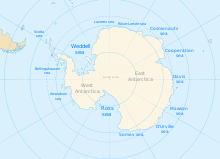
The geography of Antarctica is dominated by its south polar location and, thus, by ice. The Antarctic continent, located in the Earth's southern hemisphere, is centered asymmetrically around the South Pole and largely south of the Antarctic Circle. It is washed by the Southern Ocean or, depending on definition, the southern Pacific, Atlantic, and Indian Oceans. It has an area of more than 14.2 million km2. Antarctica is the largest ice desert in the world.

The Ross Sea is a deep bay of the Southern Ocean in Antarctica, between Victoria Land and Marie Byrd Land and within the Ross Embayment, and is the southernmost sea on Earth. It derives its name from the British explorer James Clark Ross who visited this area in 1841. To the west of the sea lies Ross Island and Victoria Land, to the east Roosevelt Island and Edward VII Peninsula in Marie Byrd Land, while the southernmost part is covered by the Ross Ice Shelf, and is about 200 miles (320 km) from the South Pole. Its boundaries and area have been defined by the New Zealand National Institute of Water and Atmospheric Research as having an area of 637,000 square kilometres (246,000 sq mi).

The Antarctic Peninsula, known as O'Higgins Land in Chile and Tierra de San Martín in Argentina, and originally as Graham Land in the United Kingdom and the Palmer Peninsula in the United States, is the northernmost part of mainland Antarctica.

The Larsen Ice Shelf is a long ice shelf in the northwest part of the Weddell Sea, extending along the east coast of the Antarctic Peninsula from Cape Longing to Smith Peninsula. It is named after Captain Carl Anton Larsen, the master of the Norwegian whaling vessel Jason, who sailed along the ice front as far as 68°10' South during December 1893. In finer detail, the Larsen Ice Shelf is a series of shelves that occupy distinct embayments along the coast. From north to south, the segments are called Larsen A, Larsen B, and Larsen C by researchers who work in the area. Further south, Larsen D and the much smaller Larsen E, F and G are also named.

Princess Astrid Coast is a portion of the coast of Queen Maud Land, Antarctica, lying between 5° and 20° E. The entire coast is bordered by ice shelves. The region was discovered by Capt. H. Halvorsen of the Sevilla (ship) in March 1931 and in 1932 was named for Princess Astrid of Norway. The ice of the continental glacier is up to 4,000 meters thick in the interior. These thick glaciers are held in place by coastal mountain ranges. On the Princess Astrid Coast, some of the ice does flow through the mountains, spilling onto the relatively flat land on the Princess Astrid Coast. Also, the cold air spills over the mountains, creating very strong and persistent winds, which makes the snow scour off the tops of the glaciers leaving pale blue patches of bare ice. On top of the coastal line is the ice shelf, which is much smoother. The glacial ice floats on the sea surface which is beyond the chaotic surface of the sea ice which has been solidifying all winter long.

Riiser-Larsen Ice Shelf is an ice shelf about 250 miles (400 km) long on the coast of Queen Maud Land, Antarctica, extending from Cape Norvegia in the north to Lyddan Island and Stancomb-Wills Glacier in the south.

The Antarctic bottom water (AABW) is a type of water mass in the Southern Ocean surrounding Antarctica with temperatures ranging from −0.8 to 2 °C (35 °F) and absolute salinities from 34.6 to 35.0 g/kg. As the densest water mass of the oceans, AABW is found to occupy the depth range below 4000 m of all ocean basins that have a connection to the Southern Ocean at that level. AABW forms the lower branch of the large-scale movement in the world's oceans through thermohaline circulation.

The Nordenskjöld Coast is located on the Antarctic Peninsula, more specifically Graham Land, which is the top region of the Peninsula. The Peninsula is a thin, long ice sheet with an Alpine-style mountain chain. The coast consists of 15m tall ice cliffs with ice shelves.

The West Antarctic Rift System is a series of rift valleys between East and West Antarctica. It encompasses the Ross Embayment, the Ross Sea, the area under the Ross Ice Shelf and a part of Marie Byrd Land in West Antarctica, reaching to the base of the Antarctic Peninsula. It has an estimated length of 3,000 km (1,900 mi) and a width of approximately 700 km (430 mi). Its evolution is due to lithospheric thinning of an area of Antarctica that resulted in the demarcation of East and West Antarctica. The scale and evolution of the rift system has been compared to that of the Basin and Range Province of the Western United States.

The geology of Antarctica covers the geological development of the continent through the Archean, Proterozoic and Phanerozoic eons.
Astrid Ridge is an undersea ridge on the continental margin of Dronning Maud Land, East Antarctica. It is present on the GEBCO 5th edition charts. The name was approved by the Advisory Committee for Undersea Features in June 1987.
The Lazarev Ice Shelf is that part of the ice shelf fringing the Princess Astrid Coast of Queen Maud Land, Antarctica, that lies between Leningradskiy Island and Verblyud Island. It is part of the western Riiser-Larsen Sea and is about 50 nautical miles (90 km) long, with Razlom Point at its western edge. The ice shelf was first photographed from the air and mapped by the Third German Antarctic Expedition, 1938–39. It was explored and mapped by the Soviet Antarctic Expedition in 1959, and named for Lieutenant Mikhail P. Lazarev, commander of the sloop Mirnyy.
The Southern Ocean, also known as the Antarctic Ocean, comprises the southernmost waters of the world ocean, generally taken to be south of 60° S latitude and encircling Antarctica. With a size of 20,327,000 km2 (7,848,000 sq mi), it is the second-smallest of the five principal oceanic divisions, smaller than the Pacific, Atlantic and Indian oceans, and larger than the Arctic Ocean.

King Haakon VII Sea is a proposed name for part of the Southern Ocean on the coast of East Antarctica.

The Cosmonauts Sea was a proposed sea name as part of the Southern Ocean, off the Prince Olav Coast and Enderby Land, Antarctica, between about 30°E and 50°E. It would have an area of 699,000 square kilometres (270,000 sq mi). It would be bordered by two other proposals from a 2002 International Hydrographic Organization (IHO) draft, a Cooperation Sea to the east and a Riiser-Larsen Sea to the west.

The Lazarev Sea is a proposed name for a marginal sea of the Southern Ocean. It would be bordered by two proposals from a 2002 International Hydrographic Organization (IHO) draft, a King Haakon VII Sea to the west and a Riiser-Larsen Sea to the east, or between the Prime Meridian of 0° and 14°E. It would stretch over an area of 929,000 km2 (359,000 sq mi).

The East Antarctic Shield or Craton is a cratonic rock body that covers 10.2 million square kilometers or roughly 73% of the continent of Antarctica. The shield is almost entirely buried by the East Antarctic Ice Sheet that has an average thickness of 2200 meters but reaches up to 4700 meters in some locations. East Antarctica is separated from West Antarctica by the 100–300 kilometer wide Transantarctic Mountains, which span nearly 3,500 kilometers from the Weddell Sea to the Ross Sea. The East Antarctic Shield is then divided into an extensive central craton that occupies most of the continental interior and various other marginal cratons that are exposed along the coast.
The Exmouth Plateau is an elongate northeast striking extensional passive margin located in the Indian Ocean roughly 3,000 meters offshore from western and northwestern Western Australia.

The Adare Basin is a geologic structural basin located north-east of Cape Adare of Antarctica, for which its named, and north of the western Ross Sea. The Adare Basin is an extensional rift basin located along a seafloor spreading center that forms the failed arm of the Tertiary spreading ridge separating East and West Antarctica, known as the West Antarctic Rift System and similar in structure to the East Africa Rift System. Centrally located in the Adare Basin is the Adare Trough. The extension of this rift system is recorded in a series of magnetic anomalies which run along the seafloor at the extinct, north–south trending, Adare spreading axis. The Adare spreading system continues unbroken into the Northern Basin underlying the adjacent Ross Sea continental shelf.

The Bransfield Basin is a back-arc rift basin located off the northern tip of the Antarctic Peninsula. The basin lies within a Northeast and Southwest trending strait that separates the peninsula from the nearby South Shetland Islands to the Northwest. The basin extends for more than 500 kilometres from Smith Island to a portion of the Hero Fracture Zone. The basin can be subdivided into three basins: Western, Central, and Eastern. The Western basin is 130 kilometres long by 70 kilometres wide with a depth of 1.3 kilometres, the Central basin is 230 kilometres long by 60 kilometres wide with a depth of 1.9 kilometres, and the Eastern basin is 150 kilometres long by 40 kilometres wide with a depth of over 2.7 kilometres. The three basins are separated by the Deception Island and Bridgeman Island. The moho depth in the region has been seismically interpreted to be roughly 34 kilometres deep.