
The continental rise is a low-relief zone of accumulated sediments that lies between the continental slope and the abyssal plain. [1] It is a major part of the continental margin, covering around 10% of the ocean floor. [1] [2]
The continental rise is a low-relief zone of accumulated sediments that lies between the continental slope and the abyssal plain. [1] It is a major part of the continental margin, covering around 10% of the ocean floor. [1] [2]
This geologic structure results from deposition of sediments, mainly due to mass wasting, the gravity-driven downhill motion of sand and other sediments. [1] Mass wasting can occur gradually, with sediments accumulating discontinuously, or in large, sudden events. [1] Large mass wasting occurrences are often triggered by sudden events such as earthquakes or oversteepening of the continental slope. [1] More gradual accumulation of sediments occurs when hemipelagic sediments suspended in the ocean slowly settle to the ocean basin. [1]
Because the continental rise lies below the continental slope and is formed from sediment deposition, it has a very gentle slope, usually ranging from 1:50 to 1:500. [1] As the continental rise extends seaward, the layers of sediment thin, and the rise merges with the abyssal plain, typically forming a slope of around 1:1000. [1]
Deposition of sediments at the mouth of submarine canyons may form enormous fan-shaped accumulations called submarine fans on both the continental slope and continental rise. [2] Alluvial or sedimentary fans are shallow cone-shaped reliefs at the base of the continental slope that merge together, forming the continental rise. [2] Erosional submarine canyons slope downward and lead to alluvial fan valleys with increasing depth. [2] It is in this zone that sediment is deposited, forming the continental rise. Alluvial fans such as the Bengal Fan, which stretches 3,000 kilometers (1,900 miles), make up one of the largest sedimentary structures in the world. [1] Many alluvial fans also contain critical oil and natural gas reservoirs, making them key points for the collection of seismic data. [1]
Beyond the continental rise stretches the abyssal plain, which lies on top of basaltic oceanic crust and spans the majority of the seafloor. [2] The abyssal plain hosts life forms which are uniquely adapted to survival in its cold, high pressure, and dark conditions. [1] The flatness of the abyssal plain is interrupted by massive underwater mountain chains near the tectonic boundaries of Earth's plates. [2] The sediments are mostly silt and clay. [1]

An alluvial fan is an accumulation of sediments that fans outwards from a concentrated source of sediments, such as a narrow canyon emerging from an escarpment. They are characteristic of mountainous terrain in arid to semiarid climates, but are also found in more humid environments subject to intense rainfall and in areas of modern glaciation. They range in area from less than 1 square kilometer (0.4 sq mi) to almost 20,000 square kilometers (7,700 sq mi).
Landforms are categorized by characteristic physical attributes such as their creating process, shape, elevation, slope, orientation, rock exposure, and soil type.

A continental shelf is a portion of a continent that is submerged under an area of relatively shallow water, known as a shelf sea. Much of these shelves were exposed by drops in sea level during glacial periods. The shelf surrounding an island is known as an insular shelf.

A turbidite is the geologic deposit of a turbidity current, which is a type of amalgamation of fluidal and sediment gravity flow responsible for distributing vast amounts of clastic sediment into the deep ocean.

The Taconic orogeny was a mountain building period that ended 440 million years ago (Ma) and affected most of modern-day New England. A great mountain chain formed from eastern Canada down through what is now the Piedmont of the east coast of the United States. As the mountain chain eroded in the Silurian and Devonian periods, sediment spread throughout the present-day Appalachians and midcontinental North America.

A submarine canyon is a steep-sided valley cut into the seabed of the continental slope, sometimes extending well onto the continental shelf, having nearly vertical walls, and occasionally having canyon wall heights of up to 5 km (3 mi), from canyon floor to canyon rim, as with the Great Bahama Canyon. Just as above-sea-level canyons serve as channels for the flow of water across land, submarine canyons serve as channels for the flow of turbidity currents across the seafloor. Turbidity currents are flows of dense, sediment laden waters that are supplied by rivers, or generated on the seabed by storms, submarine landslides, earthquakes, and other soil disturbances. Turbidity currents travel down slope at great speed, eroding the continental slope and finally depositing sediment onto the abyssal plain, where the particles settle out.
A turbidity current is most typically an underwater current of usually rapidly moving, sediment-laden water moving down a slope; although current research (2018) indicates that water-saturated sediment may be the primary actor in the process. Turbidity currents can also occur in other fluids besides water.
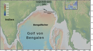
The Bengal Fan, also known as the Ganges Fan, is the largest submarine fan on Earth.

A passive margin is the transition between oceanic and continental lithosphere that is not an active plate margin. A passive margin forms by sedimentation above an ancient rift, now marked by transitional lithosphere. Continental rifting forms new ocean basins. Eventually the continental rift forms a mid-ocean ridge and the locus of extension moves away from the continent-ocean boundary. The transition between the continental and oceanic lithosphere that was originally formed by rifting is known as a passive margin.

A continental margin is the outer edge of continental crust abutting oceanic crust under coastal waters. It is one of the three major zones of the ocean floor, the other two being deep-ocean basins and mid-ocean ridges. The continental margin consists of three different features: the continental rise, the continental slope, and the continental shelf. Continental margins constitute about 28% of the oceanic area.

Abyssal fans, also known as deep-sea fans, underwater deltas, and submarine fans, are underwater geological structures associated with large-scale sediment deposition and formed by turbidity currents. They can be thought of as an underwater version of alluvial fans and can vary dramatically in size, with widths from several kilometres to several thousands of kilometres. The largest is the Bengal Fan, followed by the Indus Fan, but major fans are also found at the outlet of the Amazon, Congo, Mississippi and elsewhere.

In geology, depositional environment or sedimentary environment describes the combination of physical, chemical, and biological processes associated with the deposition of a particular type of sediment and, therefore, the rock types that will be formed after lithification, if the sediment is preserved in the rock record. In most cases, the environments associated with particular rock types or associations of rock types can be matched to existing analogues. However, the further back in geological time sediments were deposited, the more likely that direct modern analogues are not available.
A subaqueous fan is a fan-shaped deposit formed beneath water, that is commonly related to glaciers and crater lakes.

Earth Revealed: Introductory Geology, originally titled Earth Revealed, is a 26-part video instructional series covering the processes and properties of the physical Earth, with particular attention given to the scientific theories underlying geological principles. The telecourse was produced by Intelecom and the Southern California Consortium, was funded by the Annenberg/CPB Project, and first aired on PBS in 1992 with the title Earth Revealed. All 26 episodes are hosted by Dr. James L. Sadd, professor of environmental science at Occidental College in Los Angeles, California.
Abyssal channels are channels in Earth's sea floor. They are formed by fast-flowing floods of turbid water caused by avalanches near the channel's head, with the sediment carried by the water causing a build-up of the surrounding abyssal plains. Submarine channels and the turbidite systems which form them are responsible for the accumulation of most sandstone deposits found on continental slopes and have proven to be one of the most common types of hydrocarbon reservoirs found in these regions.

Submarine landslides are marine landslides that transport sediment across the continental shelf and into the deep ocean. A submarine landslide is initiated when the downwards driving stress exceeds the resisting stress of the seafloor slope material, causing movements along one or more concave to planar rupture surfaces. Submarine landslides take place in a variety of different settings, including planes as low as 1°, and can cause significant damage to both life and property. Recent advances have been made in understanding the nature and processes of submarine landslides through the use of sidescan sonar and other seafloor mapping technology.

A contourite is a sedimentary deposit commonly formed on continental rises in lower slope settings, although it may occur anywhere that is below the storm wave base. Countourites are produced by thermohaline-induced deepwater bottom currents and may be influenced by wind or tidal forces. The geomorphology of contourite deposits is mainly influenced by the deepwater bottom-current velocity, sediment supply, and seafloor topography.
The Amazon Canyon is a submarine canyon within the Amazon Fan in the Atlantic Ocean, located approximately 200 mi (322 km) from the mouth of the Amazon River, near South America. It covers an area of 2,250 km2 (870 sq mi). It was formed in the mid to late Miocene period. The canyon is believed to have formed through mass failures, and subsequently evolved through underwater erosion. Because of its relatively small size, the canyon has been extensively mapped.

Congo Canyon is a submarine canyon found at the end of the Congo River in Africa. It is one of the largest submarine canyons in the world.
Madeira Abyssal Plain, also called Madeira Plain, is an abyssal plain situated at the center and deepest part of the Canary Basin. It is a north-northeast to south-southeast elongated basin that almost parallels the Mid-Atlantic Ridge. Its western boundary is marked by a chain of seamounts known as the either Seewarte Seamounts or Atlantis-Great Meteor Seamount Chain. Its eastern boundary is a distinct break of slope that marks the foot of the African Continental Rise. This abyssal plain occupies an area of about 68,000 km2 (26,000 sq mi). Across this basin, slope angles are generally less than 0.01°.
| | This oceanography article is a stub. You can help Wikipedia by expanding it. |

