Below is a structured list of topics on oceanography.
What type of thing is oceanography?
Oceanography can be described as all of the following:
The study of the physical and biological aspects of the ocean
An academic discipline– branch of knowledge that is taught and researched at the college or university level. Disciplines are defined (in part), and recognized by the academic journals in which research is published, and the learned societies and academic departments or faculties to which their practitioners belong.
A scientific field (a branch of science) – widely recognized category of specialized expertise within science, and typically embodies its own terminology and nomenclature. Such a field will usually be represented by one or more scientific journals, where peer-reviewed research is published. There are several geophysics-related scientific journals.
Acoustical oceanography – The use of underwater sound to study the sea, its boundaries and its contents
Advection – The transport of a substance by bulk motion
Ageostrophy – The real condition that works against geostrophic wind or geostrophic currents in the ocean, and works against an exact balance between the Coriolis force and the pressure gradient force
Bottom water – The lowermost water mass in a water body
Brunt–Väisälä frequency – The angular frequency at which a vertically displaced parcel will oscillate within a statically stable environment
Cabbeling – When two separate water parcels mix to form a third which is denser and sinks below both constituents
Carbonate compensation depth – Depth in the oceans below which no calcium carbonate sediment particles are preserved
Chemocline – A cline caused by a strong, vertical chemistry gradient within a body of water
Climate inertia – The widespread inherent characteristic of the climate to take a considerable time to respond to a changed input
Cold core ring – A type of oceanic eddy, characterized as unstable, time-dependent swirling 'cells' that separate from their respective ocean current and move into water bodies with different characteristics
Color of water – The variability of water colour with ambient conditions
Conservative temperature – A thermodynamic property of seawater that represents the heat content
Coriolis frequency – Frequency of inertial oscillation at the Earth's surface resulting from the Coriolis effect
Cum sole – A Latin phrase meaning with the sun, sometimes used in meteorology and physical oceanography to refer to anticyclonic motion
Currentology – A science that studies the internal movements of water masses
Deep chlorophyll maximum – A subsurface maximum in the concentration of chlorophyll in the ocean or a lake.
Deep sea community – Groups of organisms living deep below the sea surface sharing a habitat
Deep-sea exploration – The investigation of conditions on the sea bed, for scientific or commercial purposes
Density ratio – A measure of the relative contributions of temperature and salinity in determining the density gradient in a seawater column
Dynamic topography – Elevation changes caused by the flow within the Earth's mantle
Gas hydrate stability zone – A zone and depth of the marine environment at which methane clathrates naturally exist in the Earth's crust
Ecosystem-based management – An environmental management approach that recognizes the full array of interactions within an ecosystem
Ekman velocity – Wind induced part of the total horizontal velocity in the upper layer of water of the open ocean such that Coriolis force is balanced by wind force
Ferromanganese nodules – The result of ion exchange reactions that precipitate ore components from the water (sedimentary) or out of the interstitial water of the sediments layers (diagenetic).
Geostrophic current – An oceanic flow in which the pressure gradient force is balanced by the Coriolis effect
Geostrophic wind – The theoretical wind that would result from an exact balance between the Coriolis force and the pressure gradient force
Hadley cell – A global scale tropical atmospheric circulation feature
Halocline – Stratification of a body of water due to salinity differences
Harmful algal bloom – Population explosion of organisms that can severely lower oxygen levels in natural waters, killing marine life
High-nutrient, low-chlorophyll regions – Regions of the ocean where the abundance of phytoplankton is low and fairly constant despite the availability of macronutrients
Hough function – The eigenfunctions of Laplace's tidal equations which govern fluid motion on a rotating sphere
Hydrometeorology – A branch of meteorology and hydrology that studies the transfer of water and energy between the land surface and the lower atmosphere
Isopycnal – A line connecting points of a specific density or potential density
Kolk (vortex) – An underwater vortex created when rapidly rushing water passes an underwater obstacle in boundary areas of high shear.(landform)
Langmuir circulation – A series of shallow, slow, counter-rotating vortices at the ocean's surface aligned with the wind
Lithogenic silica – Silica that originates from terrestrial sources of rock and soil
Lower shoreface – The portion of the seafloor, and the sedimentary depositional environment, that lies below the everyday wave base
Lunitidal interval – The time lag from the Moon passing overhead, to the next high or low tide.
Lysocline – Depth in the ocean below which the rate of dissolution of calcite increases dramatically
Marine clay – A type of clay found in coastal regions around the world
Marine debris – Human-created solid waste in the sea or ocean
Marine energy – Energy stored in the waters of oceans
Marine outfall – A pipeline or tunnel that discharges municipal or industrial wastewater, stormwater, combined sewer overflows, cooling water, or brine effluents from water desalination plants to the sea
Marine sediment – Deposits of insoluble particles that have accumulated on the seafloor.
Marine spatial planning – A process that brings together multiple users of the ocean – including energy, industry, government, conservation and recreation – to make informed and coordinated decisions about how to use marine resources sustainably.
Mixed layer – A layer in which active turbulence has homogenized some range of depths.
Mixing length model – A method to describe momentum transfer by turbulence Reynolds stresses within a Newtonian fluid boundary layer by means of an eddy viscosity
Mode water – A type of water mass which is nearly vertically homogeneous
Nepheloid layer – A layer of water in the deep ocean basin, above the ocean floor, that contains significant amounts of suspended sediment
Neritic zone – The relatively shallow part of the ocean above the drop-off of the continental shelf
Ocean turbidity – A measure of the amount of cloudiness or haziness in sea water caused by individual particles that are too small to be seen without magnification
Ocean zoning – A policy approach for environmental resource management in oceanic environments (political)
Orthosilicic acid – Chemical compound assumed present in dilute solutions of silicon dioxide in water
Phycosphere – A microscale mucus region that is rich in organic matter surrounding a phytoplankton cell
Pierson–Moskowitz spectrum – An empirical relationship that defines the distribution of energy with frequency within the ocean
Pockmark (geology) – Craters in the seabed caused by gas and liquids erupting and streaming through the sediments
Potential temperature – The temperature that a fluid would attain if adiabatically brought to a standard reference pressure
Potential vorticity – A simplified approach for understanding fluid motions in a rotating system
Pycnocline – Layer where the density gradient is greatest within a body of water
Region of freshwater influence – Regions where rivers debouch into estuaries and coastal shelf seas where the currents patterns are governed by density differences between salt sea water and fresh river water
Rossby radius of deformation – The length scale at which rotational effects become as important as buoyancy or gravity wave effects in the evolution of the flow about some disturbance
Salt fingering – A mixing process that occurs when relatively warm, salty water overlies relatively colder, fresher water
Sigma coordinate system – A coordinate system used in computational models for oceanography, meteorology and other fields where fluid dynamics are relevant
Submarine landslide – Landslides that transport sediment across the continental shelf and into the deep ocean
Submersion (coastal management) – Sustainable cyclic portion of coastal erosion where coastal sediments move from the visible portion of a beach to the submerged nearshore region, and later return to the original visible portion of the beach
Surface layer – The layer of a turbulent fluid most affected by interaction with a solid surface or the surface separating a gas and a liquid where the characteristics of the turbulence depend on distance from the interface
Target strength – A measure of the reflection coefficient of a sonar target
Taylor column – A fluid dynamics phenomenon that occurs as a result of the Coriolis effect
Geophysical fluid dynamics – The fluid dynamics of naturally occurring flows, such as lava flows, oceans, and planetary atmospheres, on Earth and other planets
Paleoceanography – The study of the history of the oceans in the geologic past
Physical oceanography – The study of physical conditions and physical processes within the ocean
Portal:Earth sciences – Wikipedia's portal for exploring content related to the Earth sciences
Ecology – Scientific study of the relationships between living organisms and their environment
Outline of ecology – Hierarchical outline list of articles related to ecology
Portal:Ecology – Wikipedia's portal for exploring content related to ecology
Geography – The science that studies the terrestrial surface, the societies that inhabit it and the territories, landscapes, places or regions that form it
Outline of geography – Hierarchical outline list of articles related to geography
Portal:Geography – Wikipedia's portal for exploring content related to geography
Geology – The study of the composition, structure, physical properties, and history of Earth's components, and the processes by which they are shaped.
Outline of geology – Hierarchical outline list of articles related to geology
Hydrography – Applied science of measurement and description of physical features of bodies of water
Portal:Palaeontology – Wikipedia's portal for exploring content related to palaeontology
Related technology
Fishing industry – The economic sector concerned with taking, culturing, processing, preserving, storing, transporting, marketing or selling fish or fish products
Navigation – The process of monitoring and controlling the movement of a craft or vehicle from one place to another
Offshore drilling – Mechanical process where a wellbore is drilled below the seabed
Portal:Underwater diving – Wikipedia's portal for exploring content related to underwater diving
Biological oceanography
Biological oceanography – The study of how organisms affect and are affected by the physics, chemistry, and geology of the oceanographic system
Algae scrubber – A biological water filter which uses light to grow algae which removes undesirable chemicals from the water
Algal bloom – Rapid increase or accumulation in the population of planktonic algae
Apparent oxygen utilisation – The difference between oxygen gas solubility and the measured oxygen concentration in water with the same physical and chemical properties
Artificial seawater – A mixture of dissolved mineral salts (and sometimes vitamins) that simulates seawater
Bacterioplankton – The bacterial component of the plankton that drifts in the water column
Biological pump – The ocean's biologically driven sequestration of carbon from the atmosphere to deep sea water and sediment
Biomineralization – The process by which living organisms produce minerals
Bioturbation – The reworking of soils and sediments by animals or plants
Blue carbon – The carbon captured by the world's oceans and coastal ecosystems
Brown algae – A large group of multicellular algae, comprising the class Phaeophyceae
Continental shelf pump – Hypothetical mechanism transporting carbon from shallow continental shelf waters to the adjacent deep ocean
Critical depth – A hypothesized surface mixing depth at which phytoplankton growth is precisely matched by losses of phytoplankton biomass within this depth interval
Deep chlorophyll maximum – A subsurface maximum in the concentration of chlorophyll in the ocean or a lake.
Diatom – A class of microalgae, found in the oceans, waterways and soils of the world
Diel vertical migration – A pattern of daily vertical movement characteristic of many aquatic species
Eustigmatophyte – A small group of algae with marine, freshwater and soil-living species
F-ratio – In oceanic biogeochemistry, the fraction of total primary production fuelled by nitrate
Gelatinous zooplankton – Fragile and often translucent animals that live in the water column
Heterotrophic picoplankton – The fraction of plankton composed by cells between 0.2 and 2 μm that do not perform photosynthesis
Ichthyoplankton – The eggs and larvae of fish that drift in the water column
Joint Global Ocean Flux Study – An international research programme on the fluxes of carbon between the atmosphere and ocean, and within the ocean interior
Marine biology – The scientific study of organisms that live in the ocean
Marine botany – The study of aquatic plants and algae that live in seawater of the open ocean and the littoral zone, along shorelines of the intertidal zone, and in brackish water of estuaries.
Marine life – The plants, animals and other organisms that live in the salt water of the sea or ocean, or the brackish water of coastal estuaries
Marine microorganisms – Any life form too small for the naked human eye to see that lives in a marine environment
Microalgae – Microscopic algae, typically found in freshwater and marine systems, living in both the water column and sediment
Milky seas effect – A luminous phenomenon in the ocean in which large areas of seawater appear to glow brightly enough at night to be seen by satellites orbiting Earth
Red tide – A common name for a worldwide phenomenon known as an algal bloom
Sea snot – A collection of mucus-like organic matter found in the sea
Seston – The organisms and non-living matter swimming or floating in a water body
Thin layers (oceanography) – Congregations of phytoplankton and zooplankton in the water column only a few tens of centimeters in vertical thickness
Whale feces – The excrement of whales and its role in the ecology of the oceans
Marine realms
Marine realm – Top-level grouping of marine ecoregions
Arctic realm – Group of marine ecoregions in the Arctic zone
Central Indo-Pacific – A biogeographic region of the Earth's seas, comprising the tropical waters of the western Pacific Ocean, the eastern Indian Ocean, and the connecting seas.
Indo-Pacific – A biogeographic region of the Earth's seas, comprising the tropical waters of the western Pacific Ocean, the eastern Indian Ocean, and the connecting seas.
Agulhas Current – The western boundary current of the southwest Indian Ocean that flows down the east coast of Africa
Andaman Sea – Marginal sea of the eastern Indian Ocean
Arabian Sea – A marginal sea of the northern Indian Ocean between the Arabian Peninsula and India
Benguela Current – The broad, northward flowing ocean current that forms the eastern portion of the South Atlantic Ocean gyre
Bering Sea – Marginal sea of the Pacific Ocean off the coast of Alaska, Eastern Russia and the Aleutian Islands
Canary Current – A wind-driven surface current that is part of the North Atlantic Gyre
Chesapeake Bay – An estuary in the U.S. states of Maryland and Virginia
Cocos Island – An island designated as a National Park off the shore of Costa Rica
Coral Triangle – A roughly triangular area of the tropical marine waters of Indonesia, Malaysia, Papua New Guinea, Philippines, Solomon Islands and Timor-Leste
Grand Banks of Newfoundland – A group of underwater plateaus south-east of Newfoundland on the North American continental shelf.
Great Barrier Reef – Coral reef system off the east coast of Australia, World Heritage Site
Hawkins Bank – A large, submerged bank off the Mascarene Plateau in the Indian Ocean
Hudson Complex – A marine ecoregion in Canada, part of the Arctic marine realm
Humboldt Current – A cold, low-salinity eastern boundary current that flows north along the western coast of South America from southern Chile to northern Peru
Mediterranean Sea – Sea connected to the Atlantic Ocean between Europe, Africa and Asia
Mesoamerican Barrier Reef System – A marine region from Isla Contoy at the tip of the Yucatán Peninsula down to Belize, Guatemala and the Bay Islands of Honduras
Moliço – Submerged aquatic vegetation collected for use in agriculture
Sea of Okhotsk – A marginal sea of the western Pacific Ocean, between the Kamchatka Peninsula, the Kuril Islands, the island of Hokkaido, the island of Sakhalin, and eastern Siberian coast
Bahia mangroves – A tropical ecoregion of the Mangrove forests Biome, and the South American Atlantic Forest biome, located in Northeastern Brazil
Bakhawan Eco-Park – A mangrove forest located in Kalibo, Aklan, Philippines
Belizean Coast mangroves – Ecoregion in the mangrove biome along the coast of Belize and Amatique Bay in Guatemala
Bhitarkanika Mangroves – A mangrove wetland in India's Odisha state, in the river delta of the Brahmani and Baitarani rivers
Bongsanglay Natural Park – A protected area of mangrove forests and swamps on Ticao Island in the Bicol Region of the Philippines
Myanmar Coast mangroves – An ecoregion in Burma, Malaysia, and Thailand where there were once thick forests of mangroves
Caroni Swamp – The second largest mangrove wetland in Trinidad and Tobago
Central African mangroves – The largest area of mangrove swamp in Africa, located on the coasts of West Africa, mainly in Nigeria
East African mangroves – An ecoregion of mangrove swamps along the Indian Ocean coast of East Africa in Mozambique, Tanzania, Kenya and southern Somalia
Northern Honduras mangroves – An ecoregion in the mangroves biome, along most of the Caribbean coast of Honduras, up to the east of Amatique Bay in Guatemala
Sarovaram Bio Park – Project with an eco-friendly theme and in an ecosystem of wetlands and mangrove forests containing bird habitats
Alkalinity – The capacity of water to resist changes in pH that would make the water more acidic
Anoxic event – Intervals in the Earth's past where parts of oceans were depleted of oxygen at depth over a large geographic area
Anoxic waters – Areas of sea water, fresh water, or groundwater that are depleted of dissolved oxygen
Artificial seawater – A mixture of dissolved mineral salts (and sometimes vitamins) that simulates seawater
Biogeochemistry – The study of chemical cycles of the earth that are either driven by or influence biological activity
Biological pump – The ocean's biologically driven sequestration of carbon from the atmosphere to deep sea water and sediment
Bjerrum plot – A graph of the concentrations of the different species of a polyprotic acid in a solution, as functions of the solution's pH, when the solution is at equilibrium
Blue carbon – The carbon captured by the world's oceans and coastal ecosystems
Brine rejection – Process by which salts are expelled from freezing water
Carbon cycle – Biogeochemical cycle by which carbon is exchanged among the biosphere, pedosphere, geosphere, hydrosphere, and atmosphere,
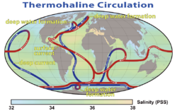
Thermohaline circulation – A part of the large-scale ocean circulation that is driven by global density gradients created by surface heat and freshwater fluxes
Total boron – The sum of boron species in a solution
Total carbon – The sum of carbon species in a solution
North Pacific Intermediate Water – A cold, moderately low salinity water mass that originates between the Kuroshio and Oyashio waters just east of Japan
Overturning in the Subpolar North Atlantic Program – An international project to study the link between water mass transformation at high latitudes and the meridional overturning circulation in the North Atlantic
Subantarctic Mode Water – A water mass formed near the Subantarctic Front on the northern flank of the Antarctic Circumpolar Current
ABISMO – A Japanese remotely operated underwater vehicle for deep sea exploration
Acoustic Doppler current profiler – A hydroacoustic current meter used to measure water current velocities over a depth range using the Doppler effect
Acoustic release – An oceanographic device for the deployment and subsequent recovery of instrumentation from the sea floor, in which the recovery is triggered remotely by an acoustic command signal
Deepsea Challenger – Deep-diving submersible designed to reach the bottom of Challenger Deep
Drifter (floating device) – An oceanographic instrument package floating freely on the surface to investigate ocean currents and other parameters like temperature or salinity
Echo sounding – Measuring the depth of water by transmitting sound waves into water and timing the return
Ekman current meter – A mechanical flowmeter invented by Vagn Walfrid Ekman, a Swedish oceanographer, in 1903
Epibenthic sled – An instrument designed to collect benthic and benthopelagic faunas from the deep sea
Fixed-point ocean observatory – An autonomous system of automatic sensors and samplers that continuously gathers data from deep sea, water column and lower atmosphere, and transmits the data to shore in real or near real-time
Flow tracer – Any fluid property used to track flow
Forel-Ule scale – A method to approximately determine the color of bodies of water using a standard colour scale
Friendly Floatees – Plastic bath toys made famous by the work of Curtis Ebbesmeyer, an oceanographer who models ocean currents on the basis of flotsam movements.
GLORIA sidescan sonar – Geological Long Range Inclined Asdic for determining the topography of the ocean floor
Hansa Carrier – Container ship which lost a cargo of identifiable shoes which were used to record ocean drift
Sofar bomb – A long-range position-fixing system that uses explosive sounds in the deep sound channel of the ocean to enable pinpointing of the location of ships or crashed planes
Tide gauge – A device for measuring the change in sea level relative to a datum
Underwater acoustic positioning system – A system for the tracking and navigation of underwater vehicles or divers by using acoustic distance and/or direction measurements, and subsequent position triangulation
Underwater glider – A type of autonomous underwater vehicle that uses small changes in its buoyancy to move up and down and uses wings to convert the vertical motion to horizontal, propelling itself forward with very low power consumption
Water remote sensing – System to measure the color of water by observing the spectrum of radiation leaving the water.
Weather buoy – Floating instrument package which collects weather and ocean data on the world's oceans
Young grab – An instrument to sample sediment in the ocean
Research vessels
Research vessel – A ship or boat designed, modified, or equipped to carry out research at sea
RRS Charles Darwin – A Royal Research Ship belonging to the British Natural Environment Research Council. Since 2006, she has been the geophysical survey vessel, RV Ocean Researcher
Jason-3 – International Earth observation satellite mission
Oceansat-1 – The first Indian satellite built specifically for Ocean applications
Oceansat-2 – An Indian satellite to provide service continuity for users of the Ocean Colour Monitor instrument on Oceansat-1
QuikSCAT – An Earth observation satellite carrying the SeaWinds scatterometer to measure the surface wind speed and direction over the ice-free global oceans
Diamantina fracture zone – An escarpment, separating two oceanic plateaus in the southeast Indian Ocean
Easter fracture zone – An oceanic fracture zone associated with the transform fault from the Tuamotu archipelago to the Peru–Chile Trench
Fifteen-Twenty fracture zone – A fracture zone on the Mid-Atlantic Ridge at the migrating triple junction between the North American, South American, and Nubian plates
Mendocino fracture zone – A fracture zone and transform boundary off the coast of Cape Mendocino in far northern California
Mocha fracture zone – A fracture zone on the Nazca plate off the coast of Mocha Island,
Owen fracture zone – A transform fault in the northwest Indian Ocean between the Arabian and African plates from the Indian plate
Panama fracture zone – A right lateral-moving transform fault and fracture zone between the Cocos plate and the Nazca plate
Romanche Trench – A trench in the Atlantic formed by the Romanche fracture zone on the Mid-Atlantic Ridge
Shackleton fracture zone – An undersea fracture zone and fault in the Drake Passage between the Scotia and Antarctic plates
Sovanco fracture zone – A right lateral-moving transform fault and fracture zone offshore of Vancouver Island in Canada
Propagating rift – A seafloor feature associated with spreading centers at mid-ocean ridges and back-arc basins
Oceanic ridges of the Arctic Ocean –
Alpha Ridge – A major volcanic ridge under the Arctic Ocean
Chukchi Cap represented by Chukchi Plateau – A large subsea formation extending north from the Alaskan margin into the Arctic Ocean
Gakkel Ridge – A mid-oceanic ridge under the Arctic Ocean between the North American plate and the Eurasian plate
Lomonosov Ridge – An underwater ridge of continental crust in the Arctic Ocean
Mendeleev Ridge – A broad ridge in the Arctic Ocean from the Siberian Shelf to the central areas of the ocean
Oceanic ridges of the Atlantic Ocean –
Aegir Ridge – An extinct mid-ocean ridge in the far-northern Atlantic Ocean
South American–Antarctic Ridge – Mid-ocean ridge in the South Atlantic between the South American plate and the Antarctic plate
Aves Ridge – A ridge in the eastern Caribbean Sea west of the Lesser Antilles Volcanic Arc
Cayman Ridge – A ridge in the eastern Caribbean Sea west of the Lesser Antilles Volcanic Arc
J-Anomaly Ridge – A ridge in the North Atlantic Ocean southeast of the Grand Banks of Newfoundland
Kings Trough – An undersea trough in the Atlantic Ocean on the east side of the Mid-Atlantic Ridge, northwest of the Açores-Biscay rise
Kolbeinsey Ridge – A segment of the Mid-Atlantic Ridge north of Iceland in the Arctic Ocean
Mid-Atlantic Ridge – A divergent tectonic plate boundary that in the North Atlantic separates the Eurasian and North American plates, and in the South Atlantic separates the African and South American plates
Rio Grande Rise – An aseismic ocean ridge in the southern Atlantic Ocean off the coast of Brazil
Southwest Indian Ridge – A mid-ocean ridge on the bed of the south-west Indian Ocean and south-east Atlantic Ocean
Walvis Ridge – An aseismic ocean ridge in the southern Atlantic Ocean.
Wyville Thomson Ridge – A feature of the North Atlantic Ocean floor between the Faroe Islands and Scotland
Oceanic ridges of the Indian Ocean –
Aden Ridge – Part of an active oblique rift system in the Gulf of Aden, between Somalia and the Arabian Peninsula
Carlsberg Ridge – The northern section of the Central Indian Ridge between the African plate and the Indo-Australian plate
Central Indian Ridge – A north-south-trending mid-ocean ridge in the western Indian Ocean
Chagos–Laccadive Ridge – A volcanic ridge and oceanic plateau between the Northern and the Central Indian Ocean.
Eighty Five East Ridge – A near-linear, aseismic, age-progressive ridge in the northeastern Indian Ocean.
Ninety East Ridge – a linear ridge on the Indian Ocean floor near the 90th meridian
Explorer Ridge – A mid-ocean ridge west of British Columbia, Canada
Cocos–Nazca spreading centre – A divergent boundary between the South American coast and the triple junction of the Nazca plate, the Cocos plate, and the Pacific plate
Gorda Ridge – A tectonic spreading center off the northern coast of California and southern Oregon
Juan de Fuca Ridge – A tectonic spreading center off the northern coast of California and southern Oregon
Mid-Pacific Mountains – An underwater mountain range from the southern tier of the Japan Trench to the Hawaiian Islands
Nazca Ridge – A submarine ridge on the Nazca plate off the west coast of South America
Norfolk Ridge – A submarine ridge between New Caledonia and New Zealand
Pacific–Antarctic Ridge – A divergent tectonic plate boundary located on the seafloor of the South Pacific Ocean, separating the Pacific plate from the Antarctic plate
Pacific-Farallon Ridge – A spreading ridge during the late Cretaceous that separated the Pacific plate to the west and the Farallon plate to the east
Pacific-Kula Ridge – A mid-ocean ridge between the Pacific and Kula plates in the Pacific Ocean during the Paleogene period
Phoenix Ridge – An ancient mid-ocean ridge between the Phoenix and Pacific plates
Shirshov Ridge – Seabed ridge on the eastern border of the Commander Basin below the Kamchatka Peninsula
Tehuantepec Ridge – A linear undersea ridge off the west coast of Mexico in the Pacific Ocean. It is the remnant of an old fracture zone
Tonga-Kermadec Ridge – An oceanic ridge in the south-west Pacific Ocean underlying the Tonga-Kermadec island arc
Oceanic ridges of the Southern Ocean –
South American–Antarctic Ridge – Mid-ocean ridge in the South Atlantic between the South American plate and the Antarctic plate
Ligeti Ridge – An undersea ridge in the Southern Ocean (Edit)
Maud Rise – An oceanic plateau in the Southern Ocean
Pacific–Antarctic Ridge – A divergent tectonic plate boundary located on the seafloor of the South Pacific Ocean, separating the Pacific plate from the Antarctic plate
Phoenix Ridge – An ancient mid-ocean ridge between the Phoenix and Pacific plates
South Tasman Rise – An area of seafloor about 1500 m deep south of Hobart, Tasmania in the Southern Ocean
Southwest Indian Ridge – A mid-ocean ridge on the bed of the south-west Indian Ocean and south-east Atlantic Ocean
Ridge volcanoes –
Axial Seamount – A submarine volcano on the Juan de Fuca Ridge west of Oregon
The Gully (Atlantic) – An underwater canyon in the Atlantic Ocean east of Nova Scotia
Hellenic Trench – A long narrow depression in the Ionian Sea
Kings Trough – An undersea trough in the Atlantic Ocean on the east side of the Mid-Atlantic Ridge, northwest of the Açores-Biscay rise
Milwaukee Deep – The deepest part of the Atlantic Ocean – part of the Puerto Rico Trench
Norwegian trench – An elongated depression in the sea floor off the southern coast of Norway
Puerto Rico Trench – An oceanic trench on a transform boundary between the Caribbean and North American plates
Romanche Trench – A trench in the Atlantic formed by the Romanche fracture zone on the Mid-Atlantic Ridge
South Sandwich Trench – A deep arcuate trench in the South Atlantic Ocean east of the South Sandwich Islands
Tongue of the Ocean – A deep oceanic trench in the Bahamas between Andros and New Providence islands
Oceanic trenches of the Indian Ocean
Diamantina Deep – Part of the Diamantina Trench southwest of Perth, Western Australia
Diamantina fracture zone – An escarpment, separating two oceanic plateaus in the southeast Indian Ocean
Sumatra Trench – Subduction trench in the Sumatra-Andaman subduction zone in the eastern Indian Ocean
Sunda Trench – An oceanic trench in the Indian Ocean near Sumatra where the Australian-Capricorn plates subduct under a part of the Eurasian plate.
Oceanic trenches of the Pacific Ocean
Aleutian Trench – An oceanic trench along the convergent plate boundary between the southern coastline of Alaska and the Aleutian islands
Farallon Trench – A subduction related tectonic formation off the coast of western California during the late to mid Cenozoic era
Galathea Depth – the portion the Philippine Trench exceeding 6,000-metre (20,000ft) depths in the south-western Pacific Ocean
Hikurangi Trough – An oceanic trench in the bed of the Pacific off the east coast of the North Island of New Zealand
Intermontane Trench – An ancient oceanic trench during the Triassic, parallel to the west coast of North America
Izu–Ogasawara Trench – Aan oceanic trench in the western Pacific, consisting of the Izu Trench and the Bonin Trench
Japan Trench – An oceanic trench – part of the Pacific Ring of Fire – off northeast Japan
Kermadec Trench – A linear ocean trench in the south Pacific north west of New Zealand
Kuril–Kamchatka Trench – An oceanic trench in the northwest Pacific off the southeast coast of Kamchatka and parallels the Kuril Island chain to meet the Japan Trench east of Hokkaido
Manila Trench – Oceanic trench in the Pacific Ocean, west of Luzon and Mindoro in the Philippines
Mariana Trench – The deepest part of Earth's oceans, where the Pacific plate is subducted under the Mariana plate
Middle America Trench – A subduction zone in the eastern Pacific off the southwestern coast of Middle America
Peru–Chile Trench – An oceanic trench in the eastern Pacific Ocean off the coast of South America
Philippine Trench – A submarine trench to the east of the Philippines in the Pacific Ocean
Puysegur Trench – A deep cleft in the floor of the south Tasman Sea south of New Zealand's South Island
Ryukyu Trench – Oceanic trench along the southeastern edge of Japan's Ryukyu Islands in the Pacific Ocean
Tonga Trench – An oceanic trench in the south-west Pacific Ocean
Yap Trench – Oceanic trench in the western Pacific Ocean
Oceanic trenches of the Southern Ocean
Tasman Fracture – An ocean trench off the south west coast of Tasmania
Oceanic trenches of ancient oceans
Tethyan Trench – An oceanic trench that existed in the northern part of the Tethys Ocean during the middle Mesozoic to early Cenozoic eras
Plate tectonics
Plate tectonics – The scientific theory that describes the large-scale motions of Earth's lithosphere
Asthenosphere – The highly viscous, mechanically weak and ductile region of the Earth's upper mantle
Convergent boundary – Region of active deformation between colliding lithospheric plates
Divergent boundary – Linear feature that exists between two tectonic plates that are moving away from each other
Flux melting – A process by which the melting point is reduced by the admixture of a material known as a flux
Fracture zone – A junction between oceanic crustal regions of different ages on the same plate left by a transform fault
Hydrothermal vent – A fissure in a planet's surface from which geothermally heated water issues
Lithosphere – The rigid, outermost shell of a terrestrial-type planet or natural satellite that is defined by its rigid mechanical properties
Oceanic crust – The uppermost layer of the oceanic portion of a tectonic plate
Outer trench swell – A subtle ridge on the seafloor near an oceanic trench, where a descending plate begins to flex and fault
Ridge push – A proposed driving force for tectonic plate motion as the result of the lithosphere sliding down the raised asthenosphere below mid-ocean ridges
Seafloor spreading – A process at mid-ocean ridges, where new oceanic crust is formed through volcanic activity and then gradually moves away from the ridge
Slab pull – That part of the motion of a tectonic plate that is caused by its subduction
Slab suction – A plate tectonic driving force of shear tractions between the subducting slab and nearby plates
Slab window – A gap that forms in a subducted oceanic plate when a mid-ocean ridge meets with a subduction zone and the ridge is subducted
Subduction – A geological process at convergent tectonic plate boundaries where one plate moves under the other
Superswell – A large area of anomalously high topography and shallow ocean regions
African superswell – A region including the Southern and Eastern African plateaus and the Southeastern Atlantic basin where exceptional tectonic uplift has occurred
Darwin Rise – A broad triangular region in the north central Pacific Ocean where there is a concentration of atolls
Transform fault – A plate boundary where the motion is predominantly horizontal
Vine–Matthews–Morley hypothesis – The first key scientific test of the seafloor spreading theory of continental drift and plate tectonics.
Volcanic arc – A chain of volcanoes formed above a subducting plate
Seamounts
Seamount – A mountain rising from the ocean seafloor that does not reach to the water's surface
Asphalt volcano – Ocean floor vents that erupt asphalt instead of lava
Guyot – An isolated underwater volcanic mountain with a flat top
Orca Seamount – Underwater volcano near King George Island in Antarctica, in the Bransfield Strait.
Rosenthal Seamount – A seamount in the Weddell Sea named for Alfred Rosenthal
Wordie Seamount – A seamount in Bransfield Strait, Antarctica
Subduction zones
Subduction zones – A geological process at convergent tectonic plate boundaries where one plate moves under the other
Aleutian subduction zone – Convergence boundary between the North American plate and the Pacific plate, that extends from the Alaska Range to the Kamchatka Peninsula.
Aleutian Trench – An oceanic trench along the convergent plate boundary between the southern coastline of Alaska and the Aleutian islands
Cascadia subduction zone – Convergent plate boundary that stretches from northern Vancouver Island to Northern California
Farallon Trench – A subduction related tectonic formation off the coast of western California during the late to mid Cenozoic era
Galathea Depth – The portion the Philippine Trench exceeding 6,000-metre (20,000ft) depths in the south-western Pacific Ocean
Hikurangi Margin – Subduction zone off the east coast of New Zealand's North Island
Hikurangi Trough – An oceanic trench in the bed of the Pacific off the east coast of the North Island of New Zealand
Intermontane Trench – An ancient oceanic trench during the Triassic, parallel to the west coast of North America
Izu–Ogasawara Trench – Aan oceanic trench in the western Pacific, consisting of the Izu Trench and the Bonin Trench
Japan Trench – An oceanic trench – part of the Pacific Ring of Fire – off northeast Japan
Kermadec Trench – A linear ocean trench in the south Pacific north west of New Zealand
Kermadec-Tonga subduction zone – A convergent plate boundary that stretches from the North Island of New Zealand northward
Kuril–Kamchatka Trench – An oceanic trench in the northwest Pacific off the southeast coast of Kamchatka and parallels the Kuril Island chain to meet the Japan Trench east of Hokkaido
Makran Trench – A subduction zone along the northeastern margin of the Gulf of Oman adjacent to the southwestern coast of Balochistan of Pakistan and the southeastern coast of Iran
Manila Trench – Oceanic trench in the Pacific Ocean, west of Luzon and Mindoro in the Philippines
Mariana Trench – The deepest part of Earth's oceans, where the Pacific plate is subducted under the Mariana plate
Middle America Trench – A subduction zone in the eastern Pacific off the southwestern coast of Middle America
Peru–Chile Trench – An oceanic trench in the eastern Pacific Ocean off the coast of South America
Philippine Trench – A submarine trench to the east of the Philippines in the Pacific Ocean
Puerto Rico Trench – An oceanic trench on a transform boundary between the Caribbean and North American plates
Puysegur Trench – A deep cleft in the floor of the south Tasman Sea south of New Zealand's South Island
Ryukyu Trench – Oceanic trench along the southeastern edge of Japan's Ryukyu Islands in the Pacific Ocean
South Sandwich Trench – A deep arcuate trench in the South Atlantic Ocean east of the South Sandwich Islands
Sumatra Trench – Subduction trench in the Sumatra-Andaman subduction zone in the eastern Indian Ocean
Sunda Trench – An oceanic trench in the Indian Ocean near Sumatra where the Australian-Capricorn plates subduct under a part of the Eurasian plate.
Tonga Trench – An oceanic trench in the south-west Pacific Ocean
Tonga-Kermadec Ridge – An oceanic ridge in the south-west Pacific Ocean underlying the Tonga-Kermadec island arc
Yap Trench – Oceanic trench in the western Pacific Ocean
Zagros fold and thrust belt – zone of deformed crustal rocks, formed in the foreland of the collision between the Arabian plate and the Eurasian plate
Submarine calderas
Submarine calderas – Volcanic calderas that are partially or fully submerged under the water of a larger ocean or lake, sometimes forming a reef, bay or harbor.
Rabaul caldera – A large volcano on the tip of the Gazelle Peninsula in East New Britain, Papua New Guinea
Raoul Island – A volcano in the Kermadec Islands, New Zealand
Santorini – A volcanic island in the southern Aegean Sea
Paleoceanography
Paleoceanography – The study of the history of the oceans in the geologic past
Anoxic event – Intervals in the Earth's past where parts of oceans were depleted of oxygen at depth over a large geographic area
Geologic temperature record – Changes in Earth's environment as determined from geologic evidence on multi-million to billion year time scales
Gulf Trough – An ancient geologic feature of Florida present during the Paleogene period
List of ancient oceans – A list of former oceans that disappeared due to tectonic movements and other geographical and climatic changes
Marine isotope stage – Alternating warm and cool periods in the Earth's paleoclimate, deduced from oxygen isotope data
Marine Isotope Stage 5 – A stage in the geologic temperature record, between 130,000 and 80,000 years ago
Marine Isotope Stage 11 – A stage in the geologic temperature record, covering the interglacial period between 424,000 and 374,000 years ago
Marine Isotope Stage 13 – A stage in the geologic temperature record, covering the interglacial period between ~524,000 and 474,000 years ago
Maui Nui – Name given to a prehistoric Hawaiian Island built from seven shield volcanoes (paleo?)
Proxy (climate) – reserved physical characteristics allowing reconstruction of past climatic conditions
Quaternary – Third and current period of the Cenozoic geological era
Termination (geomorphology) – The period of time during a glacial cycle when there is a relatively rapid transition from full glacial climates to full interglacial climates
Geostrophic current – An oceanic flow in which the pressure gradient force is balanced by the Coriolis effect
Halothermal circulation – The part of the large-scale ocean circulation that is driven by global density gradients created by surface heat and evaporation
Sverdrup – Unit of measurement of the volumetric rate of transport of ocean currents
Sverdrup balance – A theoretical relationship between the wind stress exerted on the surface of the open ocean and the vertically integrated meridional (north-south) transport of ocean water.
Thermohaline circulation – A part of the large-scale ocean circulation that is driven by global density gradients created by surface heat and freshwater fluxes
Turbidity current – An underwater current of usually rapidly moving, sediment-laden water moving down a slope
Upwelling – The replacement by deep water moving upwards of surface water driven offshore by wind
Warm core ring – A type of mesoscale eddy which breaks off from a warm ocean current. The ring is an independent circulatory system of warm water which can persist for several months
Whirlpool – Body of rotating water produced by the meeting of opposing currents
Circulation phenomena
Antarctic Circumpolar Wave – A coupled ocean/atmosphere wave that circles the Southern Ocean eastward in approximately eight years
Barents Sea Opening – The sea between Bear Island in the south of Svalbard and the north of Norway through which water flows from the Atlantic into the Arctic Ocean
Black Sea undersea river – A current of particularly saline water flowing through the Bosphorus Strait and along the seabed of the Black Sea
Interdecadal Pacific oscillation – An oceanographic/meteorological phenomenon similar to the Pacific decadal oscillation (PDO), but occurring in a wider area of the Pacific
La Niña – A coupled ocean-atmosphere phenomenon that is the counterpart of El Niño
North Atlantic oscillation – A weather phenomenon in the North Atlantic Ocean of fluctuations in the difference of atmospheric pressure at sea level between the Icelandic low and the Azores high
Ocean current – Directional mass flow of oceanic water generated by external or internal forces
Ocean gyre – Any large system of recirculating ocean currents
Pacific decadal oscillation – A robust, recurring pattern of ocean-atmosphere climate variability centered over the mid-latitude Pacific basin
Pacific–North American teleconnection pattern – A large-scale weather pattern with two modes which relates the atmospheric circulation pattern over the North Pacific Ocean with the one over the North American continent
South Pacific convergence zone – A band of low-level convergence, cloudiness and precipitation extending from the Western Pacific Warm Pool at the maritime continent south-eastwards towards French Polynesia and as far as the Cook Islands
Tropical Atlantic SST Dipole – A cross-equatorial sea surface temperature pattern that appears dominant on decadal timescales
To be sorted:
Fram Strait – The passage between Greenland and Svalbard
Moby-Duck – Book by Donovan Hohn on the Friendly Floatees
The Blob (Pacific Ocean) – A large mass of relatively warm water in the Pacific Ocean off the coast of North America (circulation)
Great Salinity Anomaly – A significant disturbance caused by a major pulse of freshwater input to the Nordic Seas
Labrador Sea Water – A water mass formed by convective processes in the Labrador Sea
Subtropical Indian Ocean Dipole – The oscillation of sea surface temperatures in which the Indian Ocean southeast of Madagascar is warmer and then colder than the eastern part off Australia
Tropical instability waves – A phenomenon in which the interface between areas of warm and cold sea surface temperatures near the equator form a regular pattern of westward-propagating waves
Currents of the Arctic Ocean
Baffin Island Current – An ocean current running south down the western side of Baffin Bay in the Arctic Ocean, along Baffin Island
Beaufort Gyre – A wind-driven ocean current in the Arctic Ocean polar region
East Greenland Current – A cold, low salinity current that extends from Fram Strait to Cape Farewell off the eastern coat of Greenland
East Iceland Current – A cold water ocean current that forms as a branch of the East Greenland Current
Labrador Current – A cold current in the Atlantic Ocean along the coasts of Labrador, Newfoundland and Nova Scotia
Lomonosov Current – A deep current in the Atlantic Ocean. from the coast of Brazil to the Gulf of Guinea
North Icelandic Jet – A deep-reaching current that flows along the continental slope of Iceland
Norwegian Current – A current that flows northeasterly along the Atlantic coast of Norway into the Barents Sea
Angola Current – A temporary ocean surface current. It is an extension of the Guinea Current, flowing near western Africa's coast
Antilles Current – A highly variable surface ocean current of warm water that flows northeasterly past the island chain that separates the Caribbean Sea and the Atlantic Ocean
Atlantic meridional overturning circulation – A system of currents in the Atlantic Ocean, having a northward flow of warm, salty water in the upper layers and a southward flow of colder, deep waters that are part of the thermohaline circulation
Azores Current – A generally eastward to southeastward-flowing current in the North Atlantic, originating near the Grand Banks of Newfoundland where it splits from the Gulf Stream
Baffin Island Current – An ocean current running south down the western side of Baffin Bay in the Arctic Ocean, along Baffin Island
Benguela Current – The broad, northward flowing ocean current that forms the eastern portion of the South Atlantic Ocean gyre
Black Sea undersea river – A current of particularly saline water flowing through the Bosphorus Strait and along the seabed of the Black Sea
Brazil Current – A warm current that flows south along the Brazilian south coast to the mouth of the Río de la Plata
Canary Current – A wind-driven surface current that is part of the North Atlantic Gyre
Cape Horn Current – A cold water current that flows west-to-east around Cape Horn
Caribbean Current – A warm ocean current that flows northwestward through the Caribbean from the east along the coast of South America into the Gulf of Mexico
East Greenland Current – A cold, low salinity current that extends from Fram Strait to Cape Farewell off the eastern coat of Greenland
East Iceland Current – A cold water ocean current that forms as a branch of the East Greenland Current
Falkland Current – A cold water current that flows northward along the Atlantic coast of Patagonia as far north as the mouth of the Río de la Plata
Florida Current – A thermal ocean current that flows from the Straits of Florida around the Florida Peninsula and along the southeastern coast of the United States before joining the Gulf Stream near Cape Hatteras
Good Hope Jet – The northward-running shelf edge frontal jet of the Southern Benguela Current off the Cape Peninsula of South Africa's west coast
Guinea Current – A slow warm water current that flows to the east along the Guinea coast of West Africa
Gulf Stream – A warm, swift Atlantic current that originates in the Gulf of Mexico flows round the tip of Florida, along the east coast of the United States before crossing the Atlantic Ocean
Irminger Current – A north Atlantic current setting westward off the southwest coast of Iceland
Labrador Current – A cold current in the Atlantic Ocean along the coasts of Labrador, Newfoundland and Nova Scotia
Lomonosov Current – A deep current in the Atlantic Ocean. from the coast of Brazil to the Gulf of Guinea
Loop Current – A warm ocean current that flows northward between Cuba and the Yucatán Peninsula into the Gulf of Mexico, loops east and south and exits to the east through the Florida Straits to join the Gulf Stream
Mann Eddy – A persistent clockwise circulation in the middle of the North Atlantic Ocean
North Atlantic Current – A powerful warm western boundary current in the north Atlantic Ocean that extends the Gulf Stream northeastward
North Brazil Current – A warm current that is part of the southwestern North Atlantic Gyre which begins by splitting from the Atlantic South Equatorial Current and flows aling the northwest coast of Brazil until it becomes the Guiana Current
Agulhas Current – The western boundary current of the southwest Indian Ocean that flows down the east coast of Africa
Agulhas Return Current – An ocean current in the South Indian Ocean flowing from the Agulhas retroflection along the subtropical front
East Madagascar Current – Current that flows southward on the east side of Madagascar and subsequently feeds the Agulhas Current
Equatorial Counter Current – An eastward moving, wind-driven current flowing 10-15m deep found in the Atlantic, Indian, and Pacific Oceans
Indian Monsoon Current – The seasonally varying ocean current regime found in the tropical regions of the northern Indian Ocean
Indonesian Throughflow – Ocean current that provides a low-latitude pathway for warm, relatively fresh water to move from the Pacific to the Indian Ocean
Leeuwin Current – A warm ocean current which flows southwards near the western coast of Australia. It rounds Cape Leeuwin to enter the waters south of Australia where its influence extends as far as Tasmania
Madagascar Current – The Madagascar current is split into two currents, the North Madagascar Current and the East Madagascar Current
Mozambique Current – A warm ocean current in the Indian Ocean flowing south along the African east coast in the Mozambique Channel
North Madagascar Current – an ocean current near Madagascar that flows into the South Equatorial Current just north of Madagascar and is directed into the Mozambique Channel
Somali Current – An ocean boundary current that flows along the coast of Somalia and Oman in the Western Indian Ocean
South Equatorial Current – Ocean current in the Pacific, Atlantic, and Indian Ocean that flows east-to-west between the equator and about 20 degrees south
West Australian Current – A cool surface current that starts as the Southern Indian Ocean Current and turns north when it approaches Western Australia
Currents of the Pacific Ocean
Alaska Current – A warm-water current flowing northwards along the coast of British Columbia and the Alaska Panhandle
Aleutian Current – An eastward flowing ocean current which lies north of the North Pacific Current;
California Current – A Pacific Ocean current that flows southward along the western coast of North America from southern British Columbia to the southern Baja California Peninsula
Cromwell Current – An eastward-flowing subsurface current that extends along the equator in the Pacific Ocean
Davidson Current – A coastal countercurrent of the Pacific Ocean flowing north along the western coast of the United States from Baja California, Mexico to northern Oregon
East Australian Current – The southward flowing western boundary current that is formed from the South Equatorial Current reaching the eastern coast of Australia
East Korea Warm Current – An ocean current in the Sea of Japan which branches off from the Tsushima Current at the eastern end of the Korea Strait, and flows north along the southeastern coast of the Korean peninsula
Equatorial Counter Current – An eastward moving, wind-driven current flowing 10-15m deep found in the Atlantic, Indian, and Pacific Oceans
Humboldt Current – A cold, low-salinity eastern boundary current that flows north along the western coast of South America from southern Chile to northern Peru
Indonesian Throughflow – Ocean current that provides a low-latitude pathway for warm, relatively fresh water to move from the Pacific to the Indian Ocean
Kamchatka Current – A cold-water current flowing south-westward from the Bering Strait, along the Siberian Pacific coast and the Kamchatka Peninsula
Kuroshio Current – North flowing ocean current on the west side of the North Pacific Ocean
Mindanao Current – A narrow, southward flowing ocean current along the eastward side of the southern Philippines
Mindanao Eddy – A semi-permanent cold-ring eddy formed in the retroflection area of the Mindanao Current.
North Equatorial Current – A Pacific and Atlantic Ocean current that flows east-to-west between about 10° north and 20° north on the southern side of a clockwise subtropical gyre
North Korea Cold Current – A cold water current in the Sea of Japan that flows southward from near Vladivostok along the coast of the Korean Peninsula
North Pacific Current – A slow warm water current that flows west-to-east between 30 and 50 degrees north in the Pacific Ocean
Oyashio Current – A cold subarctic ocean current that flows south and circulates counterclockwise in the western North Pacific Ocean
South Equatorial Current – Ocean current in the Pacific, Atlantic, and Indian Ocean that flows east-to-west between the equator and about 20 degrees south
Tasman Front – A relatively warm water east-flowing surface current and thermal boundary that separates the Coral Sea to the north and the Tasman Sea to the south
Tasman Outflow – A deepwater current that flows from the Pacific Ocean past Tasmania into the Southern Ocean that encircles Antarctica
Tasman Outflow – A deepwater current that flows from the Pacific Ocean past Tasmania into the Southern Ocean that encircles Antarctica
Ocean gyres
Ocean gyre – Any large system of recirculating ocean currents
Beaufort Gyre – A wind-driven ocean current in the Arctic Ocean polar region
Indian Ocean Gyre – A large systems of rotating ocean currents. The Indian Ocean gyre is composed of two major currents: the South Equatorial Current, and the West Australian Current
Hydrography – Applied science of measurement and description of physical features of bodies of water
Superswell – A large area of anomalously high topography and shallow ocean regions
Volcanic arc – A chain of volcanoes formed above a subducting plate
Wave-cut platform – The narrow flat area often found at the base of a sea cliff or along the shoreline of a lake, bay, or sea that was created by erosion
Windwatt – A type of mudflat exposed as a result of wind action on water
Coastal landforms
Anchialine pool – A landlocked body of water with a subterranean connection to the ocean.
Arm (geography) – A narrow extension of water extending out from a much larger body of water
Atoll – Ring-shaped coral reef, generally formed over a subsiding oceanic volcano, with a central lagoon and perhaps islands around the rim
Baïne – A pool of water between a beach and the mainland, parallel to the beach and connected to the sea at one or more points along its length
Barrier island – A coastal dune landform that forms by wave and tidal action parallel to the mainland coast
Bay – A recessed, coastal body of water connected to an ocean or lake
Baymouth bar – A depositional feature as a result of longshore drift, a sandbank that partially or completely closes access to a bay.
Beach – Area of loose particles at the edge of the sea or other body of water
Beachrock – A friable to well-cemented sedimentary rock that consists of a variable mixture of gravel-, sand-, and silt-sized sediment that is cemented with carbonate minerals and has formed along a shoreline
Beach cusps – Shoreline formations made up of various grades of sediment in an arc pattern
Beach ridge – Wave-swept or wave-deposited ridge running parallel to a shoreline
Bight (geography) – Wave-swept or wave-deposited ridge running parallel to a shoreline
Blowhole (geology) – Hole at the top of a sea-cave which allows waves to force water or spray out of the hole
Bodden– Brackish bodies of water often forming lagoons, along the southwestern shores of the Baltic Sea
Brine pool – An area of high density brine collected in a depression on the ocean floor
Cape (geography) – A large headland extending into a body of water, usually the sea
Channel (geography) – A type of landform in which part of a body of water is confined to a relatively narrow but long region
Chevron (land form) – A wedge-shaped sediment deposit observed on coastlines and continental interiors around the world
Cliff – A vertical, or near vertical, rock face of substantial height
Coastal erosion – The loss or displacement of land along the coastline due to the action of waves, currents, tides. wind-driven water, waterborne ice, or other impacts of storms
Coastal geography – The study of the region between the ocean and the land
Coastal plain – An area of flat, low-lying land adjacent to a seacoast
Cuspate foreland – Geographical features found on coastlines and lakeshores that are created primarily by longshore drift
Dune – A hill of loose sand built by aeolian processes or the flow of water
Estuary – A partially enclosed coastal body of brackish water with one or more rivers or streams flowing into it, and with a free connection to the open sea
Fajã – A supratidal talus-platform geology of landslides or lava flows at the bottom of cliffs
Faraglioni – Italian term used to refer to rock stacks
Firth – Scottish word used for various coastal inlets and straits
Perched coastline – A fossil coastline currently above the present coastline
Presque-isle – A peninsula with narrow connection to mainland
Pseudo-atoll – An island that encircles a lagoon, either partially or completely that is not formed by subsidence or coral reefs
Raised beach – A beach or wave-cut platform raised above the shoreline by a relative fall in the sea level
Raised coral atoll – An atoll that has been lifted high enough above sea level by tectonic forces to protect it from scouring by storms
Raised shoreline – An ancient shoreline exposed above current water level.
Ria – A coastal inlet formed by the partial submergence of an unglaciated river valley
Roadstead – An open anchorage affording some shelter, but less protection than a harbor
Rocky shore – An intertidal area of coast where solid rock predominates
Salt marsh – A coastal ecosystem in the upper coastal intertidal zone between land and open saltwater or brackish water that is regularly flooded by the tides
Salt pannes and pools – Water retaining depressions located within salt and brackish marshes
Sound (geography) – A long, relatively wide body of water, connecting two larger bodies of water
Spit (landform) – A coastal bar or beach landform deposited by longshore drift
Stack (geology) – A geological landform consisting of a steep and often vertical column or columns of rock in the sea near a coast, formed by wave erosion
Steep coast – A stretch of coastline where the mainland descends abruptly into the sea.
Strait – A naturally formed, narrow, typically navigable waterway that connects two larger bodies of water
Strand plain – A broad belt of sand along a shoreline with a surface exhibiting well-defined parallel or semi-parallel sand ridges separated by shallow swales
Strandflat – Stretches of coast that have been inundated by the sea by a relative rise in sea levels from either isostacy or eustacy
Submergent coastline – Stretches of coast that have been inundated by the sea by a relative rise in sea levels from either isostacy or eustacy
Surge channel – A narrow inlet, usually on a rocky shoreline, and is formed by differential erosion of those rocks by coastal wave action
Tide pool – A rocky pool on a seashore, separated from the seal at low tide, filled with seawater
Tombolo – A deposition landform in which an island is connected to the mainland by a sandy isthmus
Seamount – A mountain rising from the ocean seafloor that does not reach to the water's surface
Shoal – A natural landform that rises from the bed of a body of water to near the surface and is covered by unconsolidated material
Submarine canyon – A steep-sided valley cut into the seabed of the continental slope
Submarine volcano – Underwater vents or fissures in the Earth's surface from which magma can erupt
Undersea bank represented by Ocean bank – A part of the sea which is shallow compared to its surrounding area
Undersea mountain range – Mountain ranges that are mostly or entirely under the surface of an ocean.
Coastal and oceanic landforms – specific cases – move to another section
Cascadia Channel – An extensive deep-sea channel of the Pacific Ocean.
Darwin Mounds – A large field of undersea sand mounds off the north west coast of Scotland
Darwin's Arch – A natural rock arch feature situated to the southeast of Darwin Island in the Pacific Ocean
Florida Platform – A flat geological feature with the emergent portion forming the Florida peninsula
Hawaiian Islands – An archipelago in the North Pacific Ocean, currently administered by the US state of Hawaii (archipelago)
Milwaukee Deep – The deepest part of the Atlantic Ocean – part of the Puerto Rico Trench
Monterey Canyon – A submarine canyon in Monterey Bay, California
Northwest Atlantic Mid-Ocean Channel – The main body of a turbidity current system of channels and canyons running on the sea bottom from the Hudson Strait, through the Labrador Sea and ending at the Sohm Abyssal Plain
Porcupine Seabight – A deep-water oceanic basin on the continental margin of the northeastern Atlantic
Oceans
Ocean – A body of saline water that composes much of a planet's hydrosphere
Arctic Ocean – The smallest and shallowest of the world's five major oceans, located in the north polar regions
Atlantic Ocean – Ocean between Europe, Africa and the Americas
Indian Ocean – The ocean between Africa, Asia, Australia and Antarctica (or the Southern Ocean)
Pacific Ocean – Ocean between Asia and Australia in the west, the Americas in the east and Antarctica or the Southern Ocean in the south.
World Ocean – The interconnected system of Earth's oceanic waters
Ocean zones
Ocean zones – Not mutually exclusive
Abyssal zone – Deep layer of the ocean between 4000 and 9000 metres
Aphotic zone – The portion of a lake or ocean where less than 1% of sunlight penetrates (zones)
Bathyal zone – Part of the pelagic zone that extends from a depth of 1,000 to 4,000 meters (3,300 to 13,100ft) below the ocean surface.
Benthic zone – Ecological region at the lowest level of a body of water including the sediment surface and some sub-surface layers
Dead zone (ecology) – Hypoxic areas in oceans and large lakes caused by excessive nutrient pollution
Deep ocean water – Cold, salty water deep below the surface of Earth's oceans
Deep sea – The lowest layer in the ocean, below the thermocline and above the seabed, at a depth of 1,000 fathoms (1,800m) or more
Demersal zone – The part of the water column near to the seabed and the benthos
Fracture zone – A junction between oceanic crustal regions of different ages on the same plate left by a transform fault
Gas hydrate stability zone – A zone and depth of the marine environment at which methane clathrates naturally exist in the Earth's crust
Hadal zone – The deepest region of the ocean lying within oceanic trenches
Intertidal zone – A junction between oceanic crustal regions of different ages on the same plate left by a transform fault
Littoral zone – Part of a sea, lake or river that is close to the shore
Mesopelagic zone – The part of the pelagic zone between the photic epipelagic above and the aphotic bathypelagic below
Neritic zone – The relatively shallow part of the ocean above the drop-off of the continental shelf
Oceanic zone – The part of the ocean beyond the continental shelf
Pelagic zone – Sea water that is neither close to the bottom nor near the shore
Photic zone – The uppermost layer of water in a lake or ocean that is exposed to sunlight more than 1% of surface illumination
Subduction zone – Convergent tectonic plate boundaries where one plate moves under the other
Supralittoral zone – The area above the spring high tide line that is regularly splashed, but not submerged by ocean water
Surf zone – The nearshore zone where wave water comes onto the shore
Swash – A turbulent layer of water that washes up on the beach after an incoming wave has broken
Seas
Sea – A large body of salt water surrounded in whole or in part by land
List of seas – Large divisions of the World Ocean, including areas of water variously named as gulfs, bights, bays, and straits.
Marginal sea – Large divisions of the World Ocean, partly bordered by land.
Sargasso Sea – A sea defined by currents in the gyre in the middle of the North Atlantic Ocean
Marginal seas of the Atlantic coasts of the Americas (coast wise north to south)
Davis Strait – A northern arm of the Labrador Sea that lies between mid-western Greenland and Nunavut, Canada's Baffin Island
Labrador Sea – An arm of the North Atlantic Ocean between the Labrador Peninsula and Greenland
Gulf of St. Lawrence – The outlet of the North American Great Lakes via the Saint Lawrence River into the Atlantic Ocean
Gulf of Maine – A large gulf of the Atlantic Ocean on the east coast of North America
Bay of Fundy – A bay on the east coast of North America between New Brunswick and Nova Scotia
Massachusetts Bay – A bay on the Atlantic Ocean that forms part of the central coastline of the Commonwealth of Massachusetts.
Cape Cod Bay – A large bay of the Atlantic Ocean adjacent to the U.S. state of Massachusetts
Nantucket Sound – A roughly triangular area of the Atlantic Ocean offshore from the U.S. state of Massachusetts
Vineyard Sound – The stretch of the Atlantic Ocean which separates the Elizabeth Islands and the southwestern part of Cape Cod from the island of Martha's Vineyard
Buzzards Bay – A bay on the coast of Massachusetts, United States
Narragansett Bay – A bay and estuary on the north side of Rhode Island Sound
Rhode Island Sound – A strait off the coast of Rhode Island, United States
Block Island Sound – A strait in the Atlantic Ocean separating Block Island from the coast of mainland Rhode Island in the United States
Long Island Sound – A tidal estuary on the east coast of the United States
Shelter Island Sound – A body of water in Suffolk County, New York, at the eastern end of Long Island
Peconic Bay – The parent name for two bays between the North Fork and South Fork of Long Island in the U.S. state of New York
Gardiners Bay – A small arm of the Atlantic Ocean in the U.S. state of New York at the eastern end of Long Island
Fort Pond Bay – A bay off Long Island Sound at Montauk, New York
New York Bay – The marine areas surrounding the river mouth of the Hudson River into the Atlantic Ocean
Jamaica Bay – Bay on the southern side of Long Island, New York
Raritan Bay – The southern portion of Lower New York Bay between the U.S. states of New York and New Jersey
Delaware Bay – The estuary outlet of the Delaware River on the Northeast seaboard of the United States
Chesapeake Bay – An estuary in the U.S. states of Maryland, Delaware, District of Columbia, and Virginia
Albemarle Sound – An estuary on the coast of North Carolina, United States
Pamlico Sound – The largest lagoon along the North American East Coast
Gulf of Mexico – An ocean basin and marginal sea of the Atlantic Ocean, largely surrounded by the North American continent
Florida Bay – The bay between the southern end of the Florida mainland and the Florida Keys in the United States
Tampa Bay – Estuary and natural harbor in Florida, off the Gulf of Mexico
Pensacola Bay – A bay in the northwestern part of Florida, United States, known as the Florida Panhandle
Mobile Bay – An inlet of the Gulf of Mexico, lying within the state of Alabama in the United States
Vermillion Bay – An inlet of the Gulf of Mexico, to which it is connected to the south by a narrow strait called Southwest Pass
Bay of Campeche – A bight in the southern area of the Gulf of Mexico
Caribbean – A sea of the Atlantic Ocean bounded by North, Central, and South America
Gulf of Gonâve (Haiti) – A large gulf along the western coast of Haiti
Gulf of Honduras – A large inlet of the Caribbean Sea, indenting the coasts of Belize, Guatemala, and Honduras.
Golfo de los Mosquitos – A gulf on the north coast of Panama, extending from the Valiente Peninsula in Bocas del Toro, past the north coast of Veraguas to the province of Colón, Panama
Gulf of Venezuela – A gulf of the Caribbean Sea bounded by the Venezuelan states of Zulia and Falcón and by Guajira Department, Colombia
Gulf of Paria – A shallow semi-enclosed inland sea between the island of Trinidad and the east coast of Venezuela
Gulf of Darién – The southernmost region of the Caribbean Sea, located north and east of the border between Panama and Colombia
Argentine Sea – The sea within the continental shelf off the Argentine mainland
Marginal seas of the Atlantic coasts of Europe, Africa, and Asia
Norwegian Sea – A marginal sea in the North Atlantic Ocean, northwest of Norway
North Sea – A marginal sea of the Atlantic Ocean located between the United Kingdom, Denmark, Norway, Germany, the Netherlands, Belgium and France
Wadden Sea – An intertidal zone in the southeastern part of the North Sea (Netherlands, Germany and Denmark)
Baltic Sea – A sea in Northern Europe bounded by the Scandinavian Peninsula, the mainland of Europe, and the Danish islands
Archipelago Sea – A part of the Baltic Sea between the Gulf of Bothnia, the Gulf of Finland and the Sea of Åland, within Finnish territorial waters
Bothnian Sea – Southern part of the Gulf of Bothnia
Sea of Åland – The sea between the Finnish Åland islands and the Swedish mainland, part of the Baltic Sea
English Channel – Arm of the Atlantic Ocean that separates southern England from northern France
Irish Sea – Sea which separates the islands of Ireland and Great Britain
Celtic Sea – Part of the Atlantic Ocean south of Ireland, and west of the Bristol Channel, English Channel and Bay of Biscay over the continental shelf
Bay of Biscay – Gulf of the northeast Atlantic Ocean located south of the Celtic Sea off the west coast of France and the south coast of Spain
Cantabrian Sea – Sea in the southern Bay of Biscay off the coast of Spain
Mediterranean – Sea connected to the Atlantic Ocean between Europe, Africa and Asia
Adriatic Sea – Body of water between the Italian Peninsula and the Balkan Peninsula
Aegean Sea – Part of the Mediterranean Sea between the Greek and Anatolian peninsulas
Argolic Gulf – A gulf of the Aegean Sea off the east coast of the Peloponnese, Greece
Myrtoan Sea – Part of the Mediterranean Sea between the Cyclades and the Peleponnese
North Euboean Gulf – A gulf of the Aegean Sea that separates the northern part of the island Euboea from the mainland of Central Greece
Saronic Gulf – Gulf in the Aegean sea between the peninsulas of Attica and Argolis
Sea of Crete – Southern part of the Aegean Sea, north of Crete, east of Kythera, Antikythera, and the Ionian Sea, southeast of the Myrtoan Sea, south of the Cyclades, and west of the Dodecanese islands
South Euboean Gulf – A gulf in Central Greece, between the island of Euboea and the Greek mainland
Icarian Sea – The part of the Aegean Sea to the south of Chios, to the east of the Eastern Cyclades and west of Anatolia
Thermaic Gulf – A gulf in the northwest corner of the Aegean sea
Thracian Sea – Northernmost part of the Aegean sea
Alboran Sea – The westernmost portion of the Mediterranean Sea, lying between the Iberian Peninsula and the north of Africa
Sea of the Hebrides – A portion of the North Atlantic Ocean, off the coast of western Scotland
Marginal seas of the Arctic Ocean (clockwise from 180°)
Chukchi Sea – A marginal sea of the Arctic Ocean north of the Bering Strait
East Siberian Sea – A marginal sea in the Arctic Ocean north of Siberia
Laptev Sea – Marginal sea in the Arctic Ocean north of Siberia between the Kara Sea and the East Siberian Sea
Kara Sea – A marginal sea of the Arctic Ocean north of Siberia between Novaya Zemlya and Severnaya Zemlya
Barents Sea – A marginal sea of the Arctic Ocean north of Siberia between Novaya Zemlya and Severnaya Zemlya
Pechora Sea – A marginal sea at the northwest of Russia, the southeastern part of the Barents Sea
White Sea – A marginal sea at the northwest of Russia, the southeastern part of the Barents Sea
Queen Victoria Sea – A body of water in the Arctic Ocean, stretching from northeast of Svalbard to northwest Franz Josef Land
Wandel Sea – A body of water in the Arctic Ocean from northeast of Greenland to Svalbard
Greenland Sea – A body of water in the Arctic Ocean from northeast of Greenland to Svalbard
Lincoln Sea (recognized by IHO but not IMO) – A part of the Arctic Ocean from Cape Columbia, Canada, in the west to Cape Morris Jesup, Greenland, in the east
Baffin Bay – A marginal sea between Greenland and Baffin Island, Canada
Prince Gustaf Adolf Sea – A marginal sea of the Arctic Ocean located in Qikiqtaaluk Region, Nunavut, Canada
Amundsen Gulf – A gulf in Northwest Territories, Canada
(more to be listed)
Hudson Strait – Strait connecting the Atlantic Ocean to Hudson Bay in Canada
Hudson Bay – A large body of saltwater in northeastern Canada that drains much of north-central North America
James Bay – A bay on the southern end of the Hudson Bay, Canada
Beaufort Sea – A marginal sea of the Arctic Ocean north of the Northwest Territories, the Yukon, and Alaska
Marginal seas of the Indian Ocean
Andaman Sea – A marginal sea of the eastern Indian Ocean between the Andaman and Nicobar Islands to the west and Myanmar, Thailand, and the Malay Peninsula to the east
Gulf of Martaban – An arm of the Andaman Sea in the southern part of Burma
Arabian Sea – A marginal sea of the northern Indian Ocean between the Arabian Peninsula and India
Bay of Bengal – Northeastern part of the Indian Ocean between India and the Andaman and Nicobar Islands
Gulf of Aden – A gulf between Somalia and Djibouti in Africa and Yemen in the Arabian Peninsula
Gulf of Oman – Strait that connects the Arabian Sea with the Strait of Hormuz
Laccadive Sea – A body of water bordering India, the Maldives, and Sri Lanka.
Mozambique Channel – Indian Ocean strait between Madagascar and Mozambique
Persian Gulf – An arm of the Indian Ocean in western Asia
Red Sea – Arm of the Indian Ocean between Arabia and Africa
Timor Sea – A sea bounded to the north by the island of Timor, to the east by the Arafura Sea, to the south by Australia
Marginal seas of the Pacific coast of the Americas
Bering Sea – Marginal sea of the Pacific Ocean off the coast of Alaska, Eastern Russia and the Aleutian Islands
Chilean Sea – The portion of the Pacific Ocean lying west of the Chilean mainland
Sea of Chiloé – A marginal sea of the coast of Chile that is separated from the Pacific Ocean by Chiloé Island
Gulf of Alaska – An arm of the Pacific Ocean south of Alaska, from the Alaska Peninsula and Kodiak Island in the west to the Alexander Archipelago in the east
Gulf of California (also known as the Sea of Cortés) – A gulf of the Pacific Ocean on the coast of Mexico between Baja California and the mainland
Mar de Grau – The body of water in the Pacific Ocean under the control of the South American country of Peru.
Salish Sea – A group of coastal waterways in southwest British Columbia and northwest Washington State
Marginal seas of the Pacific coasts of Asia and Oceania
Arafura Sea – Marginal sea between Australia and Indonesian New Guinea
Bali Sea – The body of water north of the island of Bali and south of Kangean Island in Indonesia
Bismarck Sea – Marginal sea in the southwestern Pacific Ocean northeast of the island of New Guinea and south of the Bismarck Archipelago and the Admiralty Islands
Bohai Sea – The innermost gulf of the Yellow Sea and Korea Bay on the coast of Northeastern and North China
Bohol Sea (also known as the Mindanao Sea) – Marginal sea between the Visayas and Mindanao in the Philippines
Camotes Sea – A small sea in the Philippine archipelago, bordered by the islands Leyte, Bohol and Cebu
Celebes Sea – A marginal sea of the Pacific Ocean between the Sulu Archipelago, Mindanao Island, the Sangihe Islands, Sulawesi and Kalimantan
Ceram Sea – One of several small seas between the scattered islands of Indonesia
Coral Sea – A marginal sea of the South Pacific off the northeast coast of Australia
East China Sea – A marginal sea of the Pacific Ocean between the south of Korea, the south of Kyushu, Japan, the Ryukyu islands and mainland China
Flores Sea – A marginal sea in Indonesia between Sulawesi and the Sunda Islands of Flores and Sumbawa
Gulf of Carpentaria – A large, shallow sea enclosed on three sides by northern Australia and bounded on the north by the Arafura Sea
Gulf of Thailand – A shallow inlet in the western part of the South China and Eastern Archipelagic Seas
Halmahera Sea – A marginal sea in the central eastern part of the Australasian Mediterranean Sea
Java Sea – A marginal sea located between Java and Kalimantan, in Indonesia
Koro Sea – A sea in the Pacific Ocean between Viti Levu island, Fiji to the west and the Lau Islands to the east
Molucca Sea – A marginal sea bordered by the Indonesian Islands of Sulawesi to the west, Halmahera to the east, and the Sula Islands to the south
Philippine Sea – A marginal sea bordered by the Indonesian Islands of Sulawesi to the west, Halmahera to the east, and the Sula Islands to the south
Savu Sea – A small sea within Indonesia between the islands Savu, Rai Jua, Rote, Timor and Sumba
Sea of Japan – Marginal sea between Japan, Russia and Korea
Sea of Okhotsk – A marginal sea of the western Pacific Ocean, between the Kamchatka Peninsula, the Kuril Islands, the island of Hokkaido, the island of Sakhalin, and eastern Siberian coast
Seto Inland Sea – A marginal sea between Honshū, Shikoku, and Kyūshū
Sibuyan Sea – A small sea in the Philippines that separates the Visayas from the northern Philippine island of Luzon
Solomon Sea – A sea in the Pacific Ocean between Papua New Guinea and the Solomon Islands
South China Sea – A marginal sea of the Pacific Ocean from the Karimata and Malacca Straits to the Strait of Taiwan
Sulu Sea – A sea in the Philippines between Palawan, the Sulu Archipelago, Borneo and Visayas
Tasman Sea – A marginal sea of the South Pacific between Australia and New Zealand
Visayan Sea – A sea in the Philippines between Masbate, Leyte, Cebu, Negros and Panay
Yellow Sea – Sea in Northeast Asia between China and Korea
Marginal seas of the Southern Ocean
Amundsen Sea – An arm of the Southern Ocean off Marie Byrd Land in western Antarctica between Cape Flying Fish to the east and Cape Dart on Siple Island to the west
Bass Strait – Sea strait between the Australian mainland and Tasmania
Bellingshausen Sea – A part of the Southern Ocean along the west side of the Antarctic Peninsula, west of Alexander Island, east of Cape Flying Fish on Thurston Island
Cooperation Sea – A proposed sea name for part of the Southern Ocean, between Enderby Land and West Ice Shelf
Cosmonauts Sea – A proposed name for part of the Southern Ocean, off the Prince Olav Coast and Enderby Land, Antarctica, between about 30°E and 50°E
Davis Sea – A marginal sea along the coast of East Antarctica between West Ice Shelf and Shackleton Ice Shelf
D'Urville Sea – A marginal sea of the Southern Ocean, north of the coast of Adélie Land, East Antarctica
Drake Passage – body of water between South America and the South Shetland Islands of Antarctica
Great Australian Bight – Oceanic bight off the central and western portions of the southern coastline of mainland Australia
Gulf St Vincent – A large inlet of water on the southern coast of South Australia between the Yorke Peninsula and the Fleurieu Peninsula
Investigator Strait – A body of water in South Australia lying between the Yorke Peninsula, on the Australian mainland, and Kangaroo Island
King Haakon VII Sea – A proposed name for part of the Southern Ocean on the coast of East Antarctica
Lazarev Sea – A proposed name for a marginal sea of the Southern Ocean
Mawson Sea – A proposed sea name along the Queen Mary Land coast of East Antarctica east of the Shackleton Ice Shelf
Riiser-Larsen Sea – One of the marginal seas in the Southern Ocean off East Antarctica and south of the Indian Ocean
Ross Sea – A deep bay of the Southern Ocean in Antarctica
Scotia Sea – A sea at the northern edge of the Southern Ocean at its boundary with the South Atlantic Ocean. It is bounded on the west by the Drake Passage and on the north, east, and south by the Scotia Arc
Somov Sea – A proposed name for part of the Southern Ocean north of Oates Coast, Victoria Land, and of George V Coast of East Antarctica
Spencer Gulf – A large inlet in South Australia between the Eyre Peninsula and the Yorke Peninsula
Weddell Sea – Part of the Southern Ocean between Coats Land and the Antarctic Peninsula
Congelation ice – Ice that forms on the bottom of an established ice cover
Drift ice – Sea ice that is not attached to land and may move on the sea surface in response to wind and ocean currents
Drift station – A temporary or semi-permanent facility built on an ice floe
Drifting ice station – Research stations built on the ice of the high latitudes of the Arctic Ocean
Fast ice – Sea ice that is connected to the coastline, to the sea floor along shoals or to grounded icebergs
Finger rafting – Compression overlapping of floating ice cover in alternating overthrusts and underthrusts
Finnish-Swedish ice class – An ice class assigned to a vessel operating in first-year ice in the Baltic Sea
Flaw lead – A waterway opening between pack ice and fast ice
Frazil ice – A collection of loose, randomly oriented, plate or discoid ice crystals formed in supercooled turbulent water
Grease ice – A thin, soupy layer of frazil crystals clumped together, which makes the ocean surface resemble an oil slick
Iceberg – A large piece of freshwater ice broken off a glacier or ice shelf and floating in open water
Ice bridge – A frozen natural structure formed over seas, bays, rivers or lake surfaces
Ice class – A notation assigned by a classification society or a national authority to denote the additional level of strengthening and other arrangements that enable a ship to navigate through sea ice
Pancake ice – A form of ice that consists of round pieces of ice with diameters ranging from 30 centimetres (12 inches) to 3 metres
Polar Class – The ice class assigned to a ship by a classification society based on the Unified Requirements for Polar Class Ships
Polar seas – A collective term for the Arctic Ocean and the southern part of the Southern Ocean
Polynya – An area of unfrozen sea within the ice pack
Pressure ridge (ice) – A ridge formed in pack ice by accumulation of ice blocks in the convergence between floes
Seabed gouging by ice – A process that occurs when floating ice features drift into shallower areas and their bottom comes into contact with and drags along a softer seabed
Sea ice concentration – The area of sea ice relative to the total area at a given point in the ocean
Fletcher's Ice Island – A thick, tabular iceberg discovered by U.S. Air Force Colonel Joseph O. Fletcher, used as a manned scientific station in the Arctic for several years
Iceberg A-38 – A large iceberg that split from the Filchner-Ronne Ice Shelf in Antarctica in 1998
Iceberg A-68 – Antarctic iceberg from the Larsen C Ice Shelf in July 2017
Iceberg B-9 – Antarctic iceberg that calved in 1987
Iceberg B-15 – Largest recorded iceberg. Calved from the Ross Ice Shelf of Antarctica in March 2000
Iceberg B-17B – Antarctic iceberg that calved off the Ross Ice Shelf in 1999.
Iceberg B-31 – Antarctic iceberg calved from the Pine Island Glacier in 2013
Iceberg C-19 – Iceberg that calved from the Ross Ice Shelf in May 2002
Iceberg D-16 – Antarctic iceberg calved from the Fimbul Ice Shelf in 2006
Sea level
Sea level – Average level for the surface of the ocean at any given geographical position on the planetary surface
Eustatic sea level – The distance from the center of the Earth to the sea surface
Global Sea Level Observing System – An Intergovernmental Oceanographic Commission program to measure sea level globally for long-term climate change studies
Tide – The periodic change of sea levels caused by the gravitational and inertial effects of the Moon, the Sun and the rotation of the Earth
Amphidromic point – A point of zero amplitude of one harmonic constituent of the tide
Amsterdam Ordnance Datum – A vertical datum in use in large parts of Western Europe, originally created for use in the Netherlands
Chart datum – The level of water from which depths displayed on a nautical chart are measured
Discourse on the Tides – An essay by Galileo Galilei in 1616 that attempted to explain the motion of Earth's tides as a consequence of Earth's rotation and revolution around the sun
Dory Rips – Extreme tidal agitation of waters in the Bay of Fundy off the headland of Cape d'Or in Nova Scotia, Canada.
Earth tide – Displacement of the solid earth's surface caused by the gravity of the Moon and Sun
Head of tide – The farthest point upstream where a river is affected by tidal fluctuations
Horizontal Falls – A tidal phenomenon in Western Australia where the tide rises and falls faster on one side of a gap than the other, creating a waterfall up to 5m high on a spring tide
Internal tide – Internal waves at a tidal frequency generated as surface tides move stratified water up and down a slope
Intertidal zone – The area of coast between low and high tide marks
Jack Sound – A body of water between the island of Skomer and the Pembrokeshire mainland with a strong tidal race
King tide – A colloquial term for an especially high spring tide, such as a perigean spring tide.
Long period tide – Gravitational tides, typically with amplitudes of a few centimetres or less and periods longer than one day, generated by changes in the Earth's orientation relative to the Sun, Moon, and Jupiter
Lunitidal interval – The time lag from the Moon passing overhead, to the next high or low tide.
Perigean spring tide – A tide that occurs three or four times per year when the Moon's perigee coincides with a spring tide
Rip tide – A strong, offshore current that is caused by the tide pulling water through an inlet along a barrier beach, at a lagoon or inland marina where tide water flows steadily out to sea during ebb tide
Rule of twelfths – An approximation to a sine curve used as a rule of thumb for estimating a changing quantity where both the quantity and the steps are easily divisible by 12
Slack water – A short period in a body of tidal water when the water is completely unstressed, and there is no movement either way in the tidal stream, and which occurs before the direction of the tidal stream reverses
Storm surge Rise of water surface associated with a low pressure weather system
Theory of tides – The science of interpretation and prediction of deformations of astronomical bodies and their atmospheres and oceans under the gravitational loading of other astronomical bodies
Tidal atlas – A graphical representation of the geographical distribution of the strength and direction of tidal currents at intervals during the tidal cycle
Tidal bore – A hydrodynamic phenomenon in which the leading edge of the incoming tide forms a wave (or waves) of water that travels up a river or narrow bay against the direction of the river or bay's current.
Tidal diamond – Symbols on British admiralty charts that indicate the direction and speed of tidal streams
Tidal flooding – The temporary inundation of low-lying areas during exceptionally high tide events
Tidal island – Land which is connected to the mainland by a causeway which is covered by high tide and exposed at low tide
Tidal power – Technology to convert the energy from tides into useful forms of power
Tidal prism – The volume of water in an estuary or inlet between mean high tide and mean low tide,
Tidal race – A fast-moving tidal flow passing through a constriction, forming waves, eddies and strong currents
Tidal range – The vertical difference between the high tide and the succeeding low tide
Tidal resonance – Phenomenon that occurs when the tide excites a resonant mode of a part of an ocean, producing a higher tidal range
Tidal river – River where flow and level are influenced by tides
Tide gauge – A device for measuring the change in sea level relative to a datum
Tideline – Surface border where two currents in the ocean converge. Driftwood, floating seaweed, foam, and other floating debris may accumulate
Tide pool – A rocky pool on a seashore, separated from the sea at low tide, filled with seawater
Tide-predicting machine – A mechanical analogue computer, constructed and set up to predict the ebb and flow of sea tides and the variations in their heights
Tide-Predicting Machine No. 2 – A special-purpose mechanical analogue computer used by the U.S. Coast and Geodetic Survey to compute the height and time of high and low tides for specific locations
Tide table – Tabulated data used for tidal prediction which show the daily times and heights of high water and low water, usually for a particular location
Tombolo – A deposition landform in which an island is connected to the mainland by a sandy isthmus
Vanishing island – Any permanent island which is exposed at low tide but is submersed at high tide
Vertical Offshore Reference Frames (VORF) – is a set of high resolution surfaces which together define the vertical datum for hydrographic surveying and charting in the United Kingdom and Ireland
Whirlpool – Body of rotating water produced by the meeting of opposing currents
Storm tides
Storm surge Rise of water surface associated with a low pressure weather system
1978 North Sea storm surge – A storm surge which occurred over 11–12 January causing extensive coastal flooding and considerable damage on the east coast of England between the Humber and Kent
Burchardi flood – A storm tide that struck the North Sea coast of North Frisia and Dithmarschen on the night between 11 and 12 October 1634
Cyclone Berit – A very strong European windstorm in mid-November 2011
Cyclone Xaver – A winter storm that affected northern Europe in 2013
Cymbrian flood – A legendary large-scale incursion of the sea in the region of the Jutland peninsula in the period 120 to 114 BC, resulting in a permanent alteration of the coastline with much land lost
February flood of 1825 – Storm surge flood on the North Sea coast of Germany and the Netherlands
Gale of January 1976 – An extratropical cyclone and storm surge which occurred over January 1976
St. Peter's flood – Two separate storm tides that struck the coasts of Netherlands and Northern Germany in 1651
South England flood of February 1287 – A storm and storm surge that hit the southern coast of England with such ferocity that whole areas of coastline were redrawn
St. Lucia's flood – A storm tide that affected the Netherlands and Northern Germany on 14 December 1287
1928 Thames flood – A storm tide that affected the Netherlands and Northern Germany on 14 December 1287
Tidal bores
Tidal bore – A hydrodynamic phenomenon in which the leading edge of the incoming tide forms a wave (or waves) of water that travels up a river or narrow bay against the direction of the river or bay's current.
Arnside Bore – A tidal bore on the estuary of the River Kent in England
Mearim River – A river in Maranhão state of northern Brazil with a tidal bore
Helliar Holm – An uninhabited tidal island off the coast of Shapinsay in the Orkney Islands, Scotland
Hestan Island – A small tidal island in the Solway Firth, Southwest Scotland
Huney – An uninhabited tidal island due east of the island of Unst in the Shetland Islands, Scotland
Inner Holm – A small inhabited tidal island in Stromness harbour and one of the Orkney islands of Scotland
Islands of Fleet – A group of small islands in Galloway, Scotland. Ardwall and Barlocco are tidal islands
Isle Ristol – The innermost of the Summer Isles in Scotland,
Kili Holm – A tidal island in the Orkney Islands, linked to Egilsay
Lampay – An uninhabited tidal island in Loch Dunvegan, off the northwest coast of the Isle of Skye in Scotland
Oldany Island – Tidal island in Assynt, Sutherland, north-west Scotland
Oronsay, Inner Hebrides – A small tidal island south of Colonsay in the Scottish Inner Hebrides
Oronsay, Loch Bracadale – An uninhabited tidal island in Loch Bracadale on the west coast of Skye, Scotland
Rough Island, Scotland – Tidal island in the Rough Firth off the Solway Firth in Scotland
Sanday, Inner Hebrides – A tidal island of the Small Isles, in the Scottish Inner Hebrides
Sibhinis – A tidal island of the Monach Islands, lying between Ceann Iar and Ceann Ear
Soay Beag – A small, uninhabited tidal island in West Loch Tarbert, between the northern and southern parts of Harris
Castle Stalker – Tower house on a tidal islet on Loch Laich, Argyll, Scotland
Stromay – A tidal island off North Uist in the Sound of Harris, Scotland
Torsa – A tidal island off North Uist in the Sound of Harris, Scotland
Uyea, Northmavine – An uninhabited tidal island located to the northwest of Mainland, Shetland
Vallay – An uninhabited tidal island in the Scottish Outer Hebrides
West Head of Papa – A small tidal island off Papa in Shetland, one of the Scalloway Islands
Tidal islands of Northern Ireland
Nendrum Monastery – Christian monastery on Mahee Island in Strangford Lough, County Down, Northern Ireland
Tidal islands of Wales
Burry Holms – A small tidal island at the northern end of the Gower Peninsula, Wales
Cribinau – A small tidal island off the south west coast of the isle of Anglesey in Wales between Porth China and Porth Cwyfan
Gateholm – A small tidal island off the south west coast of Pembrokeshire in the south west side of Wales
Mumbles Head – a headland sited on the western edge of Swansea Bay on the southern coast of Wales
St Catherine's Island – A small tidal island linked to Tenby in Pembrokeshire, Wales
Sully Island – A small tidal island off the northern coast of the Bristol Channel near Cardiff
Ynys Cantwr – A small tidal island south of Ramsey Island, Pembrokeshire, Wales
Ynys Feurig – A set of three small inter-connected low-lying inshore tidal rocky islets off the west coast of Anglesey, North Wales
Ynys Gifftan – A tidal island near the south east shore of Traeth Bach, the Dwyryd estuary near Portmeirion in Gwynedd, north Wales
Ynys Gwelltog – A small tidal island south of Ramsey Island, Pembrokeshire, Wales
Ynys Llanddwyn – A small tidal island off the west coast of Anglesey, northwest Wales
Ynys Lochtyn – A tiny tidal island on the coast of Cardigan Bay, Wales near the village of Llangrannog in the county Ceredigion
Tidal islands of the United States
Bar Island – A tidal island across from Bar Harbor on Mount Desert Island, Maine, United States
Bumpkin Island – Tidal island in Massachusetts, United States of America
Charles Island – Tidal island off the coast of Milford, Connecticut, in Long Island Sound
Douglas Island – A tidal island in Alaska, just west of downtown Juneau and east of Admiralty Island
High Island (Bronx) – A small tidal island, part of The Pelham Islands group in the New York City borough of the Bronx
Sears Island – A tidal island off the coast of Searsport in Waldo County, Maine at the top of Penobscot Bay
Whirlpools
Whirlpool – Body of rotating water produced by the meeting of opposing currents
Charybdis – Whirlpool in the Strait of Messina named for a figure in Greek mythology
Gulf of Corryvreckan – A narrow strait between the islands of Jura and Scarba off the west coast of Scotland with an intense tidal race
Moskstraumen – A system of tidal eddies and whirlpools that forms at the Lofoten archipelago, Norway
Naruto whirlpools – Tidal whirlpools in the Naruto Strait in Hyōgo, Japan
Niagara Whirlpool – A natural whirlpool in the Niagara Gorge, downstream from Niagara Falls
Old Sow whirlpool – The largest tidal whirlpool in the Western Hemisphere, located off the southwestern shore of Deer Island, New Brunswick, Canada
Saltstraumen – A small sea strait in Norway with one of the strongest tidal currents in the world
Skookumchuck Narrows – A strait forming the entrance of Sechelt Inlet on British Columbia's Sunshine Coast in Canada
Waves
Gravity wave – Wave generated in a fluid medium or at the interface between two media when the force of gravity or buoyancy tries to restore equilibrium
ADCIRC – A high-performance, cross-platform numerical ocean circulation model
Airy wave theory – A linearised description of the propagation of gravity waves on the surface of a homogeneous fluid layer
Artificial wave – Man-made waves usually created on a specially designed surface or in a pool
Ballantine scale – A biologically defined scale for measuring the degree of exposure level of wave action on a rocky shore
Bow wave – The wave that forms at the bow of a ship when it moves through the water
Fetch (geography) – The length of water over which a given wind has blown
Following sea – A wave direction that matches the heading of a vessel
Green's law – The evolution of non-breaking surface gravity waves propagating in shallow water of gradually varying depth and width
Hull speed – The speed at which the wavelength of a vessel's bow wave is equal to the waterline length
Hundred-year wave – A statistically projected water wave, the height of which, on average, is met or exceeded once in a hundred years for a given location
Infragravity wave – Surface gravity waves with frequencies lower than the wind waves
Internal wave – Gravity waves that oscillate within a fluid medium with density variation with depth, rather than on the surface
Iribarren number – A dimensionless parameter used to model several effects of breaking surface gravity waves on beaches and coastal structures.
Kelvin wave – A wave in the ocean or atmosphere that balances Coriolis force against a topographic boundary such as a coastline
Keulegan–Carpenter number – A dimensionless quantity describing the relative importance of drag and inertia forces for bluff objects in an oscillatory fluid flow
Langmuir turbulence – A turbulent flow with coherent Langmuir circulation structures that exist and evolve over a range of spatial and temporal scales
Luke's variational principle – A mathematical description of the motion of surface waves on a fluid with a free surface, under the action of gravity.
Megatsunami – A very large wave created by a large, sudden displacement of material into a body of water
Meteotsunami – A tsunami-like wave of meteorological origin
Mild-slope equation – The combined effects of diffraction and refraction for water waves propagating over variable depth and with lateral boundaries
Modulational instability, also known as Benjamin–Feir instability – A phenomenon whereby deviations from a periodic waveform are reinforced by nonlinearity
Morison equation – a semi-empirical equation for the inline force on a body in oscillatory flow
Ocean dynamics – The description of the motion of water in the oceans
Peregrine soliton – An analytic solution of the nonlinear Schrödinger equation
Radiation stress – The depth-integrated excess momentum flux caused by the presence of the surface gravity waves, which is exerted on the mean flow
Rogue wave – Relatively large and spontaneous ocean surface waves that occur at sea
Rossby wave – A type of inertial wave in the atmospheres and oceans of planets that largely owe their properties to rotation of the planet
Malaspina Expedition – A five-year maritime scientific exploration commanded by Alessandro Malaspina and José de Bustamante y Guerra
Malaspina Expedition 2010 – An interdisciplinary research project to assess the impact of global change on the oceans and explore their biodiversity
Mission 31 – An undersea expedition organized by Fabien Cousteau in the undersea laboratory Aquarius in the Florida Keys, scuba diving to collect scientific data and IMAX footage
Siboga expedition – A Dutch zoological and hydrographic expedition to Indonesia from March 1899 to February 1900.
Snellius Expedition – A Dutch oceanographic expedition in the waters of eastern Indonesia.
SUPER HI-CAT – Research cruise to study the microbial communities and the biogeochemistry associated with the Great Pacific Garbage Patch
Valdivia Expedition – A scientific expedition organised and funded by the German Empire under Kaiser Wilhelm II and was named after the ship which was bought and outfitted for the expedition
The Voyage of the Odyssey – A 5-year program conducted by oceanographic research and education non-profit Ocean Alliance, which collected the first baseline data set on contaminants in the world's oceans
Marine Science Co-ordination Committee – A UK government committee composed of representatives from public-funded bodies who have a remit to undertake marine scientific research
Atlantic Meridional Transect – A multi-decadal oceanographic programme that undertakes biological, chemical and physical research during annual voyages between the UK and destinations in the South Atlantic
BENGAL (project) – A three-year multidisciplinary study of the abyssal benthic boundary layer in the northeast Atlantic
Expocode – A unique alphanumeric identifier for cruise labels of research vessels to avoid confusion in oceanographic data management.
FESOM – A multi-resolution ocean general circulation model that solves the equations of motion describing the ocean and sea ice using finite-element and finite-volume methods on unstructured computational grids
General circulation model – A type of climate model that uses the Navier–Stokes equations on a rotating sphere with thermodynamic terms for various energy sources
Geochemical Ocean Sections Study – A global survey of the three-dimensional distributions of chemical, isotopic, and radiochemical tracers in the ocean
Geotraces – International research programme to improve understanding of biogeochemical cycles in the oceans
Glacio-geological databases – Data on glacially associated sedimentary deposits and erosion activity from former and current ice-sheets
Global Drifter Program – Collecting measurements of surface ocean currents, sea surface temperature and sea-level atmospheric pressure using drifters
Global Ocean Ecosystem Dynamics – A core project for understanding how global change will affect the abundance, diversity and productivity of marine populations
Global Ocean Observing System – A global system for sustained observations of the ocean comprising the oceanographic component of the Global Earth Observing System of Systems
Hawaii Ocean Time-series – A long-term oceanographic study based at the University of Hawaii at Manoa
Joint Global Ocean Flux Study – An international research programme on the fluxes of carbon between the atmosphere and ocean, and within the ocean interior
Integrated Ocean Observing System – An organization of systems that routinely and continuously provides quality controlled data and information on current and future states of the oceans and Great Lakes
MIT General Circulation Model – A numerical computer method that solves the equations of motion for the ocean or atmosphere using the finite volume method
Model for Prediction Across Scales – A coupled Earth system modelling package that integrates atmospheric, oceanographic and cryospheric modelling on a variety of scales
Modular Ocean Model – A three-dimensional ocean circulation model for studying the ocean climate system
MyOcean – A series of projects granted by the European Commission to set up a pan-European capacity for ocean monitoring and forecasting
National Oceanographic Data Center – One of the national environmental data centers operated by the National Oceanic and Atmospheric Administration
NOBM – NASA Ocean Biogeochemical Model is a three-dimensional representation of coupled circulation/biogeochemical/radiative processes in the global oceans
World Ocean Review – An extensive report, dealing with the state of the world ocean, the interactions between the ocean and ecological, economical and sociopolitical conditions
Sverdrup Gold Medal Award – Award by the American Meteorological Society for contributions regarding interactions between the oceans and the atmosphere
Bulletin of Marine Science – A peer-reviewed scientific journal published by the Rosenstiel School of Marine and Atmospheric Science of the University of Miami
Estuarine, Coastal and Shelf Science – A peer-reviewed academic journal on ocean sciences, with a focus on coastal regions ranging from estuaries up to the edge of the continental shelf.
ICES Journal of Marine Science – A peer-reviewed scientific journal covering oceanography and marine biology. It is published by Oxford University Press on behalf of the International Council for the Exploration of the Sea
Journal of Applied Ichthyology – A peer-reviewed scientific journal on ichthyology, marine biology, and oceanography published by Wiley-Blackwell
This page is based on this Wikipedia article Text is available under the CC BY-SA 4.0 license; additional terms may apply. Images, videos and audio are available under their respective licenses.