
Tides are the rise and fall of sea levels caused by the combined effects of the gravitational forces exerted by the Moon and are also caused by the Earth and Moon orbiting one another.

An amphidromic point, also called a tidal node, is a geographical location which has zero tidal amplitude for one harmonic constituent of the tide. The tidal range for that harmonic constituent increases with distance from this point, though not uniformly. As such, the concept of amphidromic points is crucial to understanding tidal behaviour. The term derives from the Greek words amphi ("around") and dromos ("running"), referring to the rotary tides which circulate around amphidromic points.
The lunitidal interval measures the time lag from lunar culmination to the next high tide at a given location. It is also called the high water interval (HWI). Sometimes a term is not used for the time lag, but instead the terms age or establishment of the tide are used for the entry that is in tide tables.

A tide gauge is a device for measuring the change in sea level relative to a vertical datum. It is also known as a mareograph, marigraph, sea-level recorder and limnimeter. When applied to freshwater continental water bodies, the instrument may also be called a limnimeter.
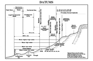
A chart datum is the water level surface serving as origin of depths displayed on a nautical chart. A chart datum is generally derived from some tidal phase, in which case it is also known as a tidal datum. Common chart datums are lowest astronomical tide (LAT) and mean lower low water (MLLW). In non-tidal areas, e.g. the Baltic Sea, mean sea level (MSL) is used. A chart datum is a type of vertical datum and must not be confused with the horizontal datum for the chart.
Established in 2002, the National Tidal and Sea Level Facility is responsible for monitoring sea levels in the UK.
The National Oceanography Centre (NOC) is a marine science research and technology institution based on two sites in Southampton and Liverpool, England. It is the UK’s largest institution for integrated sea level science, coastal and deep ocean research and technology development. The Centre was established to promote cooperation with institutions across the UK marine science community, to better address key issues including sea level change, the ocean's role is climate change, computer simulation of the ocean's behaviour, and the long term monitoring and future of the Arctic Circle.
Established in 1985, The Global Sea Level Observing System (GLOSS) is an Intergovernmental Oceanographic Commission program whose purpose is to measure sea level globally for long-term climate change studies. The program's purpose has changed since the 2004 Indian Ocean earthquake and the program now collects real time measurements of sea level. The project is currently upgrading the over 290 stations it currently runs, so that they can send real time data via satellite to newly set up national tsunami centres. They are also fitting the stations with solar panels so they can continue to operate even if the mains power supply is interrupted by severe weather. The Global Sea Level Observing System does not compete with Deep-ocean Assessment and Reporting of Tsunamis as most GLOSS transducers are located close to land masses while DART's transducers are far out in the ocean.
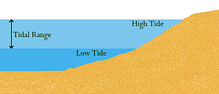
Tidal range is the difference in height between high tide and low tide. Tides are the rise and fall of sea levels caused by gravitational forces exerted by the Moon and Sun, by Earth's rotation and by centrifugal force caused by Earth's progression around the Earth-Moon barycenter. Tidal range depends on time and location.
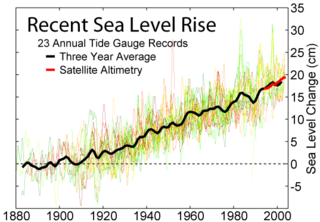
The Permanent Service for Mean Sea Level is a repository for tide gauge data used in the measurement of long-term sea level change. The PSMSL is based at the National Oceanography Centre in Liverpool, England. It was founded in 1933 as the IUGG Mean Sea Level Committee, and adopted as a Permanent Service of the International Council for Science (ICSU) in 1958.
The Australian Height Datum was introduced in 1971 as the official vertical datum for Australia, and thereby serves as the benchmark to which all height measurements are referred. The Australian Height Datum is an amalgamation of decades of spirit levelling work conducted by numerous state and territory authorities across the country, and was corrected to align with the mean sea level observations of thirty tide gauges positioned around the entire coastline. While it remains the published vertical datum for all surveying and engineering operations performed throughout Australia, newer technologies have uncovered numerous deficiencies, offsets and distortions within the Australian Height Datum, leading to discussions about defining a new Australian vertical datum.

The former Proudman Oceanographic Laboratory (POL) is based in Brownlow Street, Liverpool, England. In April 2010, POL merged with the National Oceanography Centre, Southampton (NOCS) to form the National Oceanography Centre. The Liverpool laboratory's scientific research focuses on oceanography encompassing global sea-levels and geodesy, numerical modelling of continental shelf seas and coastal sediment processes. This research alongside activities of surveying, monitoring, data management and forecasting provides strategic support for the wider mission of the Natural Environment Research Council.
The following outline is provided as an overview of and introduction to Oceanography.
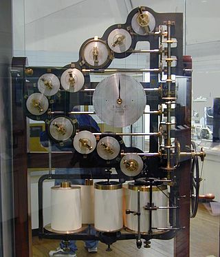
A tide-predicting machine was a special-purpose mechanical analog computer of the late 19th and early 20th centuries, constructed and set up to predict the ebb and flow of sea tides and the irregular variations in their heights – which change in mixtures of rhythms, that never repeat themselves exactly. Its purpose was to shorten the laborious and error-prone computations of tide-prediction. Such machines usually provided predictions valid from hour to hour and day to day for a year or more ahead.
The Plymouth Coastal Observatory (PCO) is the data management centre for the South West Regional Coastal Monitoring Programme. It is managed and led by Teignbridge District Council in partnership with other south west of England local authorities and the Environment Agency.
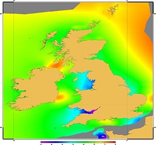
Vertical Offshore Reference Frames, also known by the acronym VORF, refers to a set of high resolution surfaces, published and maintained by the UK Hydrographic Office, which together define a vertical datum for hydrographic surveying and charting in the United Kingdom and Ireland.
Philip Leslie Woodworth is a British oceanographer based at the National Oceanography Centre. His research interests include sea level variation, climatology, and the global development of sea level monitoring networks. Woodworth studied for a degree in Physics at Durham University, graduating in 1970. He went on to complete a doctorate at the University of Birmingham in 1974.
The National Operations Centre Tidal Unit is a group of experts responsible for providing tidal tables and tidal predictions to the Australian Hydrographic Service. Their tidal predictions are also published on the Australian Bureau of Meteorology website.

