
- '"`UNIQ--templatestyles-00000001-QINU`"' Fracture zones
- '"`UNIQ--templatestyles-00000002-QINU`"' Probable extension of Fracture zones
- '"`UNIQ--templatestyles-00000003-QINU`"' Fracture zone of relevance to article
- '"`UNIQ--templatestyles-00000004-QINU`"' Probable extension relevant to article
- '"`UNIQ--templatestyles-00000005-QINU`"' Mid-oceanic ridges
- '"`UNIQ--templatestyles-00000006-QINU`"' Sea
- '"`UNIQ--templatestyles-00000007-QINU`"' Land
- Clicking on the rectangle icon enables full window and mouse-over with text detail.'"`UNIQ--ref-00000008-QINU`"'

Fracture zones are common features in the geology of oceanic basins. Globally most fault zones are located on divergent plate boundaries on oceanic crust. This means that they are located around mid-ocean ridges and trend perpendicular to them. The term fracture zone is used almost exclusively for features on oceanic crust; similar structures on continental crust are instead termed transform or strike slip faults. Some use the term "transform fault" to describe the seismically and tectonically active portion of a fracture zone after John Tuzo Wilson's concepts first developed with respect to the Mid-Atlantic Ridge. [1] The term fracture zone has a distinct geological meaning, but it is also used more loosely in the naming of some oceanic features. Fracture zones are much longer than wide, but may have feature complexity within their width. Not all named fracture zones are active, indeed only the central portion of those still forming usually is, in an area of active transform faulting associated with a mid-ocean ridge. Classic fracture zones remain significant ocean floor features with usually different aged rocks on either side of the fracture zone due to past tectonic processes. Some fracture zones have been created by mid-ocean ridge segments that have been subducted and that part may no longer exist.
Contents
- Pacific Ocean
- Chile Rise
- East Pacific Rise
- Cocos–Nazca spreading center
- Western Pacific
- West of East Pacific Rise and Gulf of California Rift Zone
- Juan de Fuca and Gorda Ridges
- Northeast Pacific
- Atlantic Ocean
- Mid-Atlantic Ridge (Northern Hemisphere)
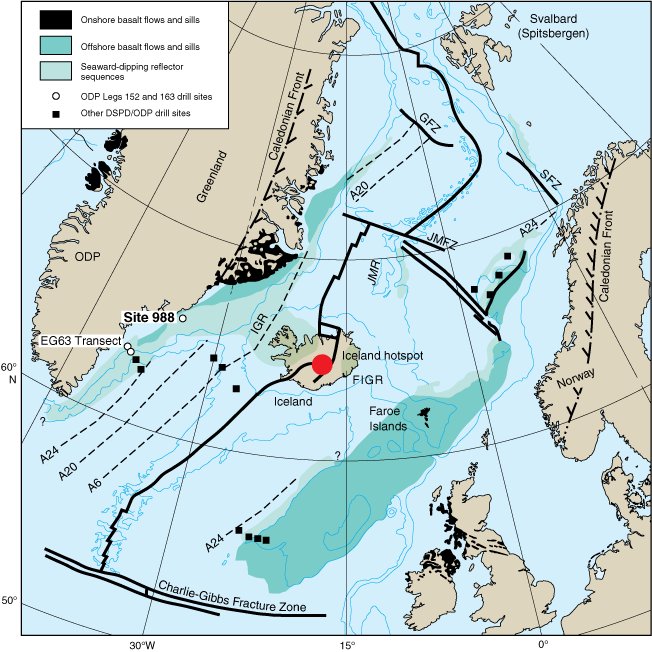
- Fracture zones involved in the early opening of the North Atlantic
- Mid-Atlantic Ridge (Southern Hemisphere)
- Indian Ocean
- Southwest Indian Ridge
- Carlsberg Ridge
- Central Indian Ridge
- Lakshadweep-Chagos Ridge
- Southeast Indian Ridge
- Southern Ocean
- References


