
The Challenger Deep is the deepest known point of the seabed of Earth, located in the western Pacific Ocean at the southern end of the Mariana Trench, in the ocean territory of the Federated States of Micronesia. According to the GEBCO Gazetteer of Undersea Feature Names the depression's depth is 10,920 ± 10 m (35,827 ± 33 ft) at 11°22.4′N142°35.5′E, although its exact geodetic location remains inconclusive and its depth has been measured at 10,902–10,929 m (35,768–35,856 ft) by deep-diving submersibles, remotely operated underwater vehicles, benthic landers, and sonar bathymetry. The differences in depth estimates and their geodetic positions are scientifically explainable by the difficulty of researching such deep locations.

North Atlantic Deep Water (NADW) is a deep water mass formed in the North Atlantic Ocean. Thermohaline circulation of the world's oceans involves the flow of warm surface waters from the southern hemisphere into the North Atlantic. Water flowing northward becomes modified through evaporation and mixing with other water masses, leading to increased salinity. When this water reaches the North Atlantic, it cools and sinks through convection, due to its decreased temperature and increased salinity resulting in increased density. NADW is the outflow of this thick deep layer, which can be detected by its high salinity, high oxygen content, nutrient minima, high 14C/12C, and chlorofluorocarbons (CFCs).

The Mid-Atlantic Ridge is a mid-ocean ridge located along the floor of the Atlantic Ocean, and part of the longest mountain range in the world. In the North Atlantic, the ridge separates the North American from the Eurasian Plate and the African Plate, north and south of the Azores Triple Junction. In the South Atlantic, it separates the African and South American plates. The ridge extends from a junction with the Gakkel Ridge northeast of Greenland southward to the Bouvet Triple Junction in the South Atlantic. Although the Mid-Atlantic Ridge is mostly an underwater feature, portions of it have enough elevation to extend above sea level, for example in Iceland. The ridge has an average spreading rate of about 2.5 centimetres (1 in) per year.

The Gakkel Ridge is a mid-oceanic ridge, a divergent tectonic plate boundary between the North American Plate and the Eurasian Plate. It is located in the Eurasian Basin of the Arctic Ocean, between Greenland and Siberia. Geologically, it connects the northern end of the Mid-Atlantic Ridge with the Laptev Sea Rift.

The Tonga Trench is an oceanic trench located in the southwestern Pacific Ocean. It is the deepest trench in the Southern hemisphere and the second deepest on Earth after the Mariana Trench. The fastest plate-tectonic velocity on Earth is occurring at this location, as the Pacific Plate is being subducted westward in the trench.

The East Greenland Current (EGC) is a cold, low-salinity current that extends from Fram Strait (~80N) to Cape Farewell (~60N). The current is located off the eastern coast of Greenland along the Greenland continental margin. The current cuts through the Nordic Seas and through the Denmark Strait. The current is of major importance because it directly connects the Arctic to the Northern Atlantic, it is a major contributor to sea ice export out of the Arctic, and it is a major freshwater sink for the Arctic.
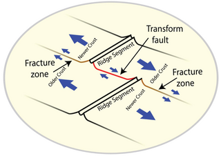
A fracture zone is a linear feature on the ocean floor—often hundreds, even thousands of kilometers long—resulting from the action of offset mid-ocean ridge axis segments. They are a consequence of plate tectonics. Lithospheric plates on either side of an active transform fault move in opposite directions; here, strike-slip activity occurs. Fracture zones extend past the transform faults, away from the ridge axis; are usually seismically inactive, although they can display evidence of transform fault activity, primarily in the different ages of the crust on opposite sides of the zone.

The Greenland Sea is a body of water that borders Greenland to the west, the Svalbard archipelago to the east, Fram Strait and the Arctic Ocean to the north, and the Norwegian Sea and Iceland to the south. The Greenland Sea is often defined as part of the Arctic Ocean, sometimes as part of the Atlantic Ocean. However, definitions of the Arctic Ocean and its seas tend to be imprecise or arbitrary. In general usage the term "Arctic Ocean" would exclude the Greenland Sea. In oceanographic studies the Greenland Sea is considered part of the Nordic Seas, along with the Norwegian Sea. The Nordic Seas are the main connection between the Arctic and Atlantic oceans and, as such, could be of great significance in a possible shutdown of thermohaline circulation. In oceanography the Arctic Ocean and Nordic Seas are often referred to collectively as the "Arctic Mediterranean Sea", a marginal sea of the Atlantic.

The Diamantina Fracture Zone (DFZ) is an area of the south-eastern Indian Ocean seafloor, consisting of a range of ridges and trenches. It lies to the south of the mideastern Indian Ocean features of the Wharton Basin and Perth Basin, and to the south west of the Naturaliste Plateau.
Litke Deep is an oceanic trench in the Arctic Ocean. The deepest point, also referred to as Litke Deep, is 5,449 m (17,877 ft) below sea level. It is the closest point of the upper surface of Earth's lithosphere to Earth's center, with Challenger Deep being 14.7268 km (9.2 mi) further from Earth's centre at a bathymetric depth of 6,366.4311 km (3,955.9 mi).
The Eurasian Basin, or Eurasia Basin, is one of the two major basins into which the Arctic Basin of the Arctic Ocean is split by the Lomonosov Ridge. The Eurasia Basin may be seen as an extension of the North Atlantic Basin through Fram Strait. It is further split by the mid-ocean Gakkel Ridge into the Nansen Basin and the Amundsen Basin. The latter basin is the deepest one of the Arctic Ocean and the geographic North Pole is located there.

SCICEX, standing for Scientific Ice Expeditions, was a five-year (1995–1999) scientific research program involving a collaboration between the U.S. Navy and academic researchers from a variety of different universities. The object of study was geophysical and oceanological conditions in the Arctic Ocean. The Navy made available a nuclear submarine for each research cruise.

The Arctic Ocean is the smallest and shallowest of the world's five major oceans. It spans an area of approximately 14,060,000 km2 (5,430,000 sq mi) and is known as one of the coldest of oceans. The International Hydrographic Organization (IHO) recognizes it as an ocean, although some oceanographers call it the Arctic Mediterranean Sea. It has also been described as an estuary of the Atlantic Ocean. It is also seen as the northernmost part of the all-encompassing World Ocean.

The Fram Strait is the passage between Greenland and Svalbard, located roughly between 77°N and 81°N latitudes and centered on the prime meridian. The Greenland and Norwegian Seas lie south of Fram Strait, while the Nansen Basin of the Arctic Ocean lies to the north. Fram Strait is noted for being the only deep connection between the Arctic Ocean and the World Oceans. The dominant oceanographic features of the region are the West Spitsbergen Current on the east side of the strait and the East Greenland Current on the west.

The Sirena Deep, originally named the HMRG Deep, was discovered in 1997 by a team of scientists from Hawaii. Its directly measured depth of 10,714 m (35,151 ft) is third only to the Challenger Deep and Horizon Deep, currently the deepest known directly measured places in the ocean. It lies along the Mariana Trench, 200 kilometers to the east of the Challenger Deep and 145 km south of Guam.

The West Spitsbergen Current (WSC) is a warm, salty current that runs poleward just west of Spitsbergen,, in the Arctic Ocean. The WSC branches off the Norwegian Atlantic Current in the Norwegian Sea. The WSC is of importance because it drives warm and salty Atlantic Water into the interior Arctic. The warm and salty WSC flows north through the eastern side of Fram Strait, while the East Greenland Current (EGC) flows south through the western side of Fram Strait. The EGC is characterized by being very cold and low in salinity, but above all else it is a major exporter of Arctic sea ice. Thus, the EGC combined with the warm WSC makes the Fram Strait the northernmost ocean area having ice-free conditions throughout the year in all of the global ocean.

The Nansen Basin is an abyssal plain with water-depths of around 3 km in the Arctic Ocean and part of the Eurasian Basin. It is named after Fridtjof Nansen. The Nansen Basin is bounded by the Gakkel Ridge on the one side and by the Barents Sea continental shelf on the other.
The Boreas Plain is an abyssal plain in the South of Fram Strait with water depths of around 3 km at 78°N0°E.
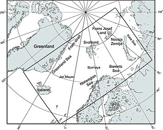
The Nordic Seas are located north of Iceland and south of Svalbard. They have also been defined as the region located north of the Greenland-Scotland Ridge and south of the Fram Strait-Spitsbergen-Norway intersection. Known to connect the North Pacific and the North Atlantic waters, this region is also known as having some of the densest waters, creating the densest region found in the North Atlantic Deep Water. The deepest waters of the Arctic Ocean are connected to the worlds other oceans through Nordic Seas and Fram Strait. There are three seas within the Nordic Sea: Greenland Sea, Norwegian Sea, and Iceland Sea. The Nordic Seas only make up about 0.75% of the World's Oceans. This region is known as having diverse features in such a small topographic area, such as the mid oceanic ridge systems. Some locations have shallow shelves, while others have deep slopes and basins. This region, because of the atmosphere-ocean transfer of energy and gases, has varying seasonal climate. During the winter, sea ice is formed in the western and northern regions of the Nordic Seas, whereas during the summer months, the majority of the region remains free of ice.
Margo Helen Edwards is a marine geologist known for mapping of the seafloor and hydrothermal vents. She led the 1999 SCICEX and was the first women to live aboard a United States' Navy submarine while doing under-ice research.

