The Challenger Deep is the deepest known point of the seabed of Earth, located in the western Pacific Ocean at the southern end of the Mariana Trench, in the ocean territory of the Federated States of Micronesia. According to the GEBCO Gazetteer of Undersea Feature Names the depression's depth is 10,920 ± 10 m (35,827 ± 33 ft) at 11°22.4′N142°35.5′E, although its exact geodetic location remains inconclusive and its depth has been measured at 10,902–10,929 m (35,768–35,856 ft) by deep-diving submersibles, remotely operated underwater vehicles and benthic landers, and (sometimes) slightly more by sonar bathymetry. The differences in depth estimates and their geodetic positions are scientifically explainable by the difficulty of researching such deep locations.

Argo is an international programme for researching the ocean. It uses profiling floats to observe temperature, salinity and currents. Recently it has observed bio-optical properties in the Earth's oceans. It has been operating since the early 2000s. The real-time data it provides support climate and oceanographic research. A special research interest is to quantify the ocean heat content (OHC). The Argo fleet consists of almost 4000 drifting "Argo floats" deployed worldwide. Each float weighs 20–30 kg. In most cases probes drift at a depth of 1000 metres. Experts call this the parking depth. Every 10 days, by changing their buoyancy, they dive to a depth of 2000 metres and then move to the sea-surface. As they move they measure conductivity and temperature profiles as well as pressure. Scientists calculate salinity and density from these measurements. Seawater density is important in determining large-scale motions in the ocean.

An underwater glider is a type of autonomous underwater vehicle (AUV) that employs variable-buoyancy propulsion instead of traditional propellers or thrusters. It employs variable buoyancy in a similar way to a profiling float, but unlike a float, which can move only up and down, an underwater glider is fitted with hydrofoils that allow it to glide forward while descending through the water. At a certain depth, the glider switches to positive buoyancy to climb back up and forward, and the cycle is then repeated.
A Nansen bottle is a device for obtaining samples of water at a specific depth. It was designed in 1894 by Fridtjof Nansen and further developed by Shale Niskin in 1966.
The World Ocean Circulation Experiment (WOCE) was a component of the international World Climate Research Program, and aimed to establish the role of the World Ocean in the Earth's climate system. WOCE's field phase ran between 1990 and 1998, and was followed by an analysis and modeling phase that ran until 2002. When the WOCE was conceived, there were three main motivations for its creation. The first of these is the inadequate coverage of the World Ocean, specifically in the Southern Hemisphere. Data was also much more sparse during the winter months than the summer months, and there was—and still to some extent—a critical need for data covering all seasons. Secondly, the data that did exist was not initially collected for studying ocean circulation and was not well suited for model comparison. Lastly, there were concerns involving the accuracy and reliability of some measurements. The WOCE was meant to address these problems by providing new data collected in ways designed to "meet the needs of global circulation models for climate prediction."
A mooring in oceanography is a collection of devices connected to a wire and anchored on the sea floor. It is the Eulerian way of measuring ocean currents, since a mooring is stationary at a fixed location. In contrast to that, the Lagrangian way measures the motion of an oceanographic drifter, the Lagrangian drifter.
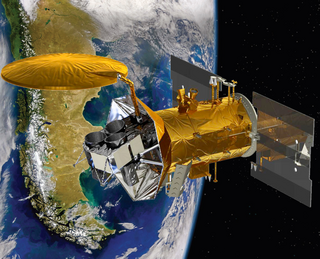
Aquarius was a NASA instrument aboard the Argentine SAC-D spacecraft. Its mission was to measure global sea surface salinity to better predict future climate conditions.

A drifter is an oceanographic device floating on the surface to investigate ocean currents by tracking location. They can also measure other parameters like sea surface temperature, salinity, barometric pressure, and wave height. Modern drifters are typically tracked by satellite, often GPS. They are sometimes called Lagrangian drifters since the location of the measurements they make moves with the flow. A major user of drifters is NOAA's Global Drifter Program.
The following are considered ocean essential climate variables (ECVs) by the Ocean Observations Panel for Climate (OOPC) that are currently feasible with current observational systems.

The River, Estuary, and Coastal Observing Network (RECON) is a pioneering waterway observing system founded and maintained by Sanibel-Captiva Conservation Foundation (SCCF) operated by the SCCF's Marine Laboratory at Tarpon Bay.

The Sentry is an autonomous underwater vehicle (AUV) made by the Woods Hole Oceanographic Institution. Sentry is designed to descend to depths of 6,000 metres (20,000 ft) and to carry a range of devices for taking samples, pictures and readings from the deep sea.
A sound velocity probe is a device that is used for measuring the speed of sound, specifically in the water column, for oceanographic and hydrographic research purposes.
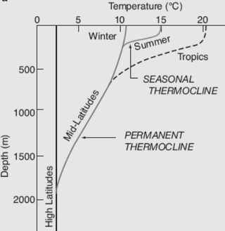
Several factors cause the ocean temperature to vary. These are depth, geographical location and season. Both the temperature and salinity of ocean water differ. Warm surface water is generally saltier than the cooler deep or polar waters. In polar regions, the upper layers of ocean water are cold and fresh. Deep ocean water is cold, salty water found deep below the surface of Earth's oceans. This water has a uniform temperature of around 0-3 °C. The ocean temperature also depends on the amount of solar radiation falling on its surface. In the tropics, with the Sun nearly overhead, the temperature of the surface layers can rise to over 30 °C (86 °F). Near the poles the temperature in equilibrium with the sea ice is about −2 °C (28 °F). There is a continuous circulation of water in the oceans. Thermohaline circulation (THC) is part of the large-scale ocean circulation. It is driven by global density gradients created by surface heat and freshwater fluxes. Warm surface currents cool as they move away from the tropics. This happens as the water becomes denser and sinks. Changes in temperature and density move the cold water back towards the equator as a deep sea current. Then it eventually wells up again towards the surface.
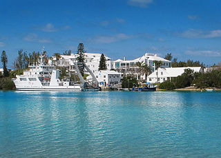
RV Atlantic Explorer is a twin-screw ocean vessel. It is owned and operated by the Bermuda Institute of Ocean Sciences (BIOS) in coordination with and as a part of the University-National Oceanographic Laboratory System (UNOLS) fleet. Atlantic Explorer is in compliance with US Coast Guard, UNOLS and American Bureau of Shipping (ABS) regulations as an uninspected oceanographic research vessel and is supported by the National Science Foundation (NSF). Its homeport is St. George's, Bermuda.
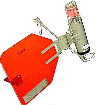
A rotor current meter (RCM) is a mechanical current meter, an oceanographic device deployed within an oceanographic mooring measuring the flow within the world oceans to learn more about ocean currents. Many RCMs have been replaced by instruments measuring the flow by hydroacoustics, the so-called Acoustic Doppler Current Profilers. However, for instance in Fram Strait, the Alfred Wegener Institute still uses RCMs for long-term monitoring the inflow into the Arctic Ocean.
The Tropical Atmosphere Ocean (TAO) project is a major international effort that instrumented the entire tropical Pacific Ocean with approximately 70 deep ocean moorings. The development of the TAO array in 1985 was motivated by the 1982-1983 El Niño event and ultimately designed for the study of year-to-year climate variations related to El Niño and the Southern Oscillation (ENSO). Led by the TAO Project Office of the Pacific Marine Environmental Laboratory (PMEL), the full array of 70 moorings was completed in 1994.

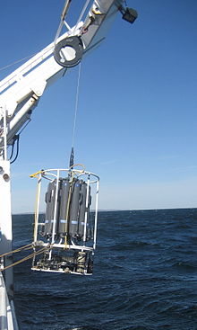
A rosette sampler is a device used for water sampling in deep water. Rosette samplers are used in the ocean and large inland water bodies such as the North American Great Lakes in order to investigate quality. Rosette samplers are a key piece of equipment in oceanography and have been used to collect information over many years in repeat hydrographic surveys.

A float is an oceanographic instrument platform used for making subsurface measurements in the ocean without the need for a ship, propeller, or a person operating it. Floats measure the physical and chemical aspects of the ocean in detail, such as measuring the direction and speed of water or the temperature and salinity. A float will descend to a predetermined depth where it will be neutrally buoyant. Once a certain amount of time has passed, most floats will rise back to the surface by increasing its buoyancy so it can transmit the data it collected to a satellite. A float can collect data while it is neutrally buoyant or moving through the water column. Often, floats are treated as disposable, as the expense of recovering them from remote areas of the ocean is prohibitive; when the batteries fail, a float ceases to function, and drifts at depth until it runs aground or floods and sinks. In other cases, floats are deployed for a short time and recovered.

A fixed-point ocean observatory is an ocean observing autonomous system of automatic sensors and samplers that continuously gathers data from deep sea, water column and lower atmosphere, and transmits the data to shore in real or near real-time.
The Haline contraction coefficient, abbreviated as β, is a coefficient that describes the change in ocean density due to a salinity change, while the potential temperature and the pressure are kept constant. It is a parameter in the Equation Of State (EOS) of the ocean. β is also described as the saline contraction coefficient and is measured in [kg]/[g] in the EOS that describes the ocean. An example is TEOS-10. This is the thermodynamic equation of state.


