Greenland Sea

Last updated

Greenland Sea
Iceberg, Greenland Sea (js)1.jpg
Greenland Sea iceberg
Greenland edcp relief location map.jpg
Red pog.svg
Greenland Sea
Fram Strait map.png
Location Northern America and Northern Europe
Coordinates 76°N8°W / 76°N 8°W / 76; -8
Type Sea
Basin  countries Greenland, Iceland, and Norway
Surface area1,205,000 km2 (465,300 sq mi)
Average depth1,444 m (4,738 ft)
Max. depth4,846 m (15,899 ft)
Water volume1,747,250 km3 (419,000 cu mi)
References [1] [2]

The Greenland Sea is a body of water that borders Greenland to the west, the Svalbard archipelago to the east, Fram Strait and the Arctic Ocean to the north, and the Norwegian Sea and Iceland to the south. The Greenland Sea is often defined as part of the Arctic Ocean, [1] [2] [3] sometimes as part of the Atlantic Ocean. [4] However, definitions of the Arctic Ocean and its seas tend to be imprecise or arbitrary. In general usage the term "Arctic Ocean" would exclude the Greenland Sea. [5] In oceanographic studies the Greenland Sea is considered part of the Nordic Seas, along with the Norwegian Sea. The Nordic Seas are the main connection between the Arctic and Atlantic oceans and, as such, could be of great significance in a possible shutdown of thermohaline circulation. In oceanography the Arctic Ocean and Nordic Seas are often referred to collectively as the "Arctic Mediterranean Sea", a marginal sea of the Atlantic. [6] [7] [8]

Contents

The sea has Arctic climate with regular northern winds and temperatures rarely rising above 0 °C (32 °F). It previously contained the Odden ice tongue (or Odden) area, which extended eastward from the main East Greenland ice edge in the vicinity of 7274°N during the winter and acted as a key winter ice formation area in the Arctic. The West Ice forms in winter in the Greenland Sea, north of Iceland, between Greenland and Jan Mayen island. It is a major breeding ground of harp seal and hooded seal that has been used for seal hunting for more than 200 years.

Extent

The International Hydrographic Organization defines the limits of the Greenland Sea as follows: [9]

On the North. A line joining the Northernmost point of Spitzbergen [sic][ Svalbard ] to the Northernmost point of Greenland.

On the East. The West coast of West Spitzbergen [sic] [island of Spitsbergen ].

On the Southeast. A line joining the Southernmost point of West Spitzbergen [sic] to the Northern point of Jan Mayen Island, down the West coast of that island to its Southern extreme, thence a Line to the Eastern extreme of Gerpir (67°05′N, 13°30′W) [sic, actually at 65°05′N13°30′W / 65.083°N 13.500°W / 65.083; -13.500 ] in Iceland.

On the Southwest. A line joining Straumnes (NW extreme of Iceland) to Cape Nansen ( 68°15′N29°30′W / 68.250°N 29.500°W / 68.250; -29.500 ) in Greenland.

On the West. The East and Northeast coast of Greenland between Cape Nansen and the northernmost point.

History

While the sea has been known for millennia,[ citation needed ] the first scientific investigations were carried out in 1876–1878 as part of the Norwegian North-Atlantic Expedition. [10] Since then, many countries, mostly Norway, Iceland and Russia have sent scientific expeditions to the area. The complex water current system in the Greenland Sea was described in 1909 by Fridtjof Nansen. [2]

The Greenland Sea was a popular hunting ground for the whaling industry for 300 years, until 1911, primarily based in Spitsbergen. At that point, the formerly rich whale population here, was so depleted that the industry was no longer profitable. The remaining whales of the Greenland Sea has been protected ever since, but the populations have not shown any proof of significant regeneration. Since the late 1990s, polar biologists reports an increase in the local bowhead whale population and in 2015, arctic scientists discovered a surprising abundance of them in a small area. These results may be interpreted as an early sign of a beginning recovery for this particular species, that once formed the largest bowhead population in the world, at an estimated 52,000 whales. [11]

The Inuit hunted whales on a non-industrial scale in the Greenland Sea since the 15th century, as evidenced by archaeology. [11]

The first complete man-powered crossing of the Greenland Sea was achieved in 2017 by rowing expedition, Polar Row led by Fiann Paul. [12] [13]

Sea topography GreenlandSeaPolarProjectionTopo.jpg
Sea topography

Geography and geology

Eyjafjordur, the longest fjord in Northern Iceland, belongs to the Greenland Sea. Grenland Sea Dalvik.jpg
Eyjafjörður, the longest fjord in Northern Iceland, belongs to the Greenland Sea.

The Greenland Sea is bounded to the west by the island of Greenland, and to the south by the Denmark Strait and Iceland. To the southeast, behind the Jan Mayen island (Norway) lies the vast expanse of the Norwegian Sea, of which Greenland Sea may be considered an extension. Across the Fram Strait to the northeast, the sea is delimited by the Svalbard archipelago (Norway). The southern part of the Greenland Sea, roughly the area south of the Jan Mayen Francture Zone or the line Cape Brewster – Jan Mayen is sometimes referred to as Iceland Sea. [14]

The bottom of the Greenland Sea is a depression bounded to the south by the underwater Greenland-Iceland ridge and to the east by the Mohns Ridge and Knipovich Ridge (parts of the Mid-Atlantic Ridge). To the west, the bottom rises first slowly, but then rapidly toward the wide Greenland coastal strip. [1] Silts fill the submarine hollows and gorges; silty sands, gravel, boulders, and other products of erosion coat the shelves and ridges. [2]

Although the deepest point inside of the sea is 4,846 m (15,899 ft), depths down to 5,570 m (18,270 ft) have been measured in the Molloy Deep of the Fram Strait which connects the sea to the Arctic Ocean on the north. [15] The Greenland ice sheet reaches down to the sea at Jokel Bay. [16]

Major islands of the Greenland Sea include the Svalbard archipelago, Jan Mayen as well as coastal islands off the NE Greenland shores, such as Hovgaard, Ella, Godfred Hansen, Île-de-France, Lynn, Norske, Gamma and Schnauder islands. Of those, only the Svalbard islands are inhabited, [17] and Jan Mayen has only temporal military staff. After the League of Nations gave Norway jurisdiction over the island, in 1921 Norway opened the first meteorological station there, which was a subject of contention between Germany and United Kingdom during World War II. [18] Several radio and meteorological stations operate on the island nowadays.

Hydrology, climate, and ice

A beach on Jan Mayen island Jan mayen egg-oeja hg.jpg
A beach on Jan Mayen island

The climate is Arctic and varies significantly across the vast sea area. Air temperatures fluctuate between −49 °C (−56 °F) near Spitsbergen in winter and 25 °C (77 °F) off Greenland in summer. Averages are −10 °C (14 °F) in the south and −26 °C (−15 °F) in the north in February, which is the coldest month. The corresponding values for the warmest month, August, are 5 °C (41 °F) in the south and 0 °C (32 °F) in the north. [1] [2] The summer is very short: The number of days per year when the temperature rises above 0 °C (32 °F) varies between 225 in the north to 334 in the south. The annual precipitation is 250 mm (10 in) in the north, but 500 mm (20 in) in the south.

Northern winds continue through the whole year, cooling the surface water and bringing ice to the south. The average surface water temperature is about −1 °C (30 °F) or lower in the north and 1–2 °C (34–36 °F) in the south; the corresponding summer temperatures are about 0 and 6 °C (32 and 43 °F) respectively. [2] The bottom water temperatures are below −1 °C (30 °F). The surface water salinity is 3.30–3.45% in the eastern and below 3.20% in the western parts, increasing to 3.49% toward the bottom. The water is green. Tides are semidiurnal with the average height of 4.4 m (14.4 ft). Together with the water currents, they break up the floating ice sheets and mix various water layers both laterally and along the depth. [1] [2]

The progressively colder waters of North Atlantic Current sink in the Arctic Ocean, returning south in the form of cold East Greenland Current, an important part of the Atlantic conveyor belt, which flows along the western part of the sea. Along the eastern part flows the warm Spitsbergen Current, a part of Gulf Stream. Mixtures of cold, freshwater ice melt and the warm, salty Spitsbergen Current may experience cabbeling, which might contribute to thermohaline circulation. The combination of those currents creates a counter-clockwise water flow in the central part of the sea. [1] [19] [20]

Because of frequent fogs, winds, and currents, which continuously transport ice and icebergs through the Greenland Sea to the south, the Greenland Sea has a narrow window for commercial navigation: The ice season starts in October and ends in August. Three types of floating ice are distinguished: Arctic pack ice (several meters thick), sea ice (about a meter thick), and freshwater icebergs. [2]

West Ice

Frazil ice Nilas Sea Ice1.jpg
Frazil ice

In winter, a large area north of Iceland between Greenland and Jan Mayen, called West Ice, is covered by continuous ice. It is a major breeding ground for seals, including harp seal, hooded seal, and gray seal. [21] [22] It was discovered in the early 18th century by British whalers and since late 1750s was used for seal hunting. The hunting was especially intensive in the 19th century, but declined in the 20th century because of hunting restrictions and lower market demand. [23] Around 5 April 1952, a major storm resulted in disappearance of ships with 79 Norwegian seal hunters on board. Seven other Norwegian seal hunting vessels shipwrecked the same month. [24] [25] [26] [27]

Odden ice tongue

Pancake ice Pancakeice ross sea.jpg
Pancake ice

The Odden ice tongue or simply the Odden (Odden is Norwegian word for headland) was a key winter ice formation area in the Arctic. It was known for a long time and was encountered by Fridtjof Nansen but was only fully understood with the advent of satellite imagery. [28]

The Odden had a length of about 1,300 km (810 mi) and covered an area of up to 330,000 km2 (130,000 sq mi) in most years. It extended eastward from the main East Greenland ice edge in the vicinity of 72–74°N during the winter because of the presence of very cold polar surface water in the Jan Mayen Current, which diverts some water eastward from the East Greenland Current at that latitude. Most of the already formed ice continued floating south, driven by the wind, so a cold open water surface was exposed on which new ice formed as frazil ice and pancake ice in the rough seas, producing a giant tongue shape. [29] The salt rejected back into the ocean from this ice formation caused the surface water to become denser and sink, sometimes to great depths (2,500 m (8,200 ft) or more), making this one of the few regions of the ocean where winter convection occurred, which helped drive the entire worldwide system of surface and deep currents known as the thermohaline circulation. [19] [20] Since the 1990s, the Odden ice tongue rarely develops. [30]

Fauna

The Greenland Sea is densely inhabited by the organisms that form the base of the oceanic food chain. Large invertebrates, fish (such as cod, herring, redfish, halibut, and plaice), birds, and mammals (including various species of seals, whales, and dolphins) all feed on the smaller invertebrates and small organisms. Mosses, lichens, and scanty bushes around the coasts serve as food to the deer and musk oxen, which in turn are hunted by the polar bear. [2]

The Greenland Sea was formerly home to a large population of various whale species, especially bowhead whales, but the whaling industry decimated them greatly from the beginning of the 1600s till 1911. In the last few decades there have been a few signs indicating a beginning recovery. [11]

Oil and gas

US Geological Survey has estimated that at least 13% of the world's undiscovered oil deposits and 30% of the world's undiscovered gas pockets are located in the Arctic, with the Greenland Sea potentially holding large amounts of natural gas and lesser amounts of natural gas liquids and crude oil. [31] [32] This has led the Greenland's minister and provincial council to offer a large number of off-shore concessions to potential hydrocarbon (oil and gas) extraction. The majority of the concessions are located in seas west of Greenland (primarily the Davis Strait and Baffin Bay), but with 19 concessions in the Greenland Sea. [33] [34]

In late 2013, a total of three consortia obtained hydrocarbon extraction rights to four large areas of the Greenland Sea from the Greenland Bureau of Mineral and Petroleum. The consortia are led by the oil companies of Statoil, Chevron, and Eni, but includes several other smaller companies such as Shell, BP, DONG Energy and Nunaoil. Since then, a fifth hydrocarbon concession has been sold. [35] [36] ExxonMobil, the largest oil company in the world and with a lot of experience in the Arctic, was also applying for oil extraction rights in the Greenland Sea initially, but pulled out in December 2013 for unexplained reasons, concentrating efforts on shale gas and the American market instead. [37] [38]

Drilling for oil in deep waters in an ice-filled Arctic environment is a potential new undertaking for the oil industry, and poses many risks and dangers. Because of these difficulties, the Greenland Minister Council expects the first exploratory drills to take place no sooner than the mid 2020s. They estimate that a full preliminary program with seismic surveys, exploratory drills, and proper safety measures will take about 16 years and an investment of about US$500 million in each concession. [33] [38]

See also

Related Research Articles

<span class="mw-page-title-main">Jan Mayen</span> Norwegian island in the Arctic Ocean

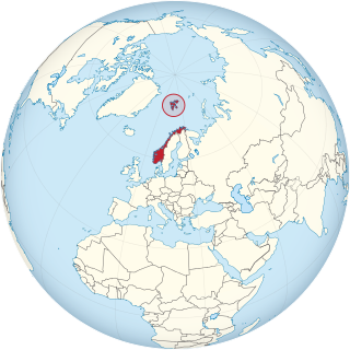
Jan Mayen is a Norwegian volcanic island in the Arctic Ocean with no permanent population. It is 55 km (34 mi) long (southwest-northeast) and 373 km2 (144 sq mi) in area, partly covered by glaciers. It has two parts: larger northeast Nord-Jan and smaller Sør-Jan, linked by a 2.5 km (1.6 mi) wide isthmus. It lies 600 km (370 mi) northeast of Iceland, 500 km (310 mi) east of central Greenland, and 900 km (560 mi) northwest of Vesterålen, Norway. The island is mountainous, the highest summit being the Beerenberg volcano in the north. The isthmus is the location of the two largest lakes of the island, Sørlaguna and Nordlaguna. A third lake is called Ullerenglaguna. Jan Mayen was formed by the Jan Mayen hotspot and is defined by geologists as a microcontinent.

<span class="mw-page-title-main">Norwegian Sea</span> Marginal sea of the Arctic or Atlantic Ocean, northwest of Norway

The Norwegian Sea is a marginal sea, grouped with either the Atlantic Ocean or the Arctic Ocean, northwest of Norway between the North Sea and the Greenland Sea, adjoining the Barents Sea to the northeast. In the southwest, it is separated from the Atlantic Ocean by a submarine ridge running between Iceland and the Faroe Islands. To the north, the Jan Mayen Ridge separates it from the Greenland Sea.

<span class="mw-page-title-main">Svalbard</span> Norwegian archipelago in the Arctic Ocean

Svalbard, previously known as Spitsbergen or Spitzbergen, is a Norwegian archipelago in the Arctic Ocean. North of mainland Europe, it lies about midway between the northern coast of Norway and the North Pole. The islands of the group range from 74° to 81° north latitude, and from 10° to 35° east longitude. The largest island is Spitsbergen, followed in size by Nordaustlandet and Edgeøya. The largest settlement is Longyearbyen on the west coast of Spitsbergen.

<span class="mw-page-title-main">Spitsbergen</span> Largest island of the Svalbard archipelago in northern Norway

Spitsbergen, is the largest and the only permanently populated island of the Svalbard archipelago in northern Norway.

<span class="mw-page-title-main">Bear Island (Svalbard)</span> Southernmost island of Svalbard, Norway

Bear Island is the southernmost island of the Norwegian Svalbard archipelago. The island is located at the limits of the Norwegian and Barents Seas, approximately halfway between Spitsbergen and the North Cape. Bear Island was discovered by Dutch explorers Willem Barentsz and Jacob van Heemskerck on 10 June 1596. It was named after a polar bear that was seen swimming nearby. The island was considered terra nullius until the Spitsbergen Treaty of 1920 placed it under Norwegian sovereignty.

<span class="mw-page-title-main">Svalbard and Jan Mayen</span> Two parts of Norway under separate jurisdictions

Svalbard and Jan Mayen is a statistical designation defined by ISO 3166-1 for a collective grouping of two remote jurisdictions of Norway: Svalbard and Jan Mayen. While the two are combined for the purposes of the International Organization for Standardization (ISO) category, they are not administratively related. This has further resulted in the country code top-level domain .sj being issued for Svalbard and Jan Mayen, and ISO 3166-2:SJ. The United Nations Statistics Division also uses this code, but has named it the Svalbard and Jan Mayen Islands.

<span class="mw-page-title-main">Ocean current</span> Directional mass flow of oceanic water generated by external or internal forces

An ocean current is a continuous, directed movement of seawater generated by a number of forces acting upon the water, including wind, the Coriolis effect, breaking waves, cabbeling, and temperature and salinity differences. Depth contours, shoreline configurations, and interactions with other currents influence a current's direction and strength. Ocean currents are primarily horizontal water movements.

<span class="mw-page-title-main">Baffin Bay</span> Marginal sea between Greenland and Baffin Island, Canada

Baffin Bay, located between Baffin Island and the west coast of Greenland, is defined by the International Hydrographic Organization as a marginal sea of the Arctic Ocean. It is sometimes considered a sea of the North Atlantic Ocean. It is connected to the Atlantic via Davis Strait and the Labrador Sea. The narrower Nares Strait connects Baffin Bay with the Arctic Ocean. The bay is not navigable most of the year because of the ice cover and high density of floating ice and icebergs in the open areas. However, a polynya of about 80,000 km2 (31,000 sq mi), known as the North Water, opens in summer on the north near Smith Sound. Most of the aquatic life of the bay is concentrated near that region.

<span class="mw-page-title-main">East Greenland Current</span> Current from Fram Strait to Cape Farewell off the eastern coat of Greenland

The East Greenland Current (EGC) is a cold, low-salinity current that extends from Fram Strait (~80N) to Cape Farewell (~60N). The current is located off the eastern coast of Greenland along the Greenland continental margin. The current cuts through the Nordic Seas and through the Denmark Strait. The current is of major importance because it directly connects the Arctic to the Northern Atlantic, it is a major contributor to sea ice export out of the Arctic, and it is a major freshwater sink for the Arctic.

<span class="mw-page-title-main">Norwegian Polar Institute</span> Norwegian government agency

The Norwegian Polar Institute is Norway's central governmental institution for scientific research, mapping and environmental monitoring in the Arctic and the Antarctic. The NPI is a directorate under Norway's Ministry of Climate and Environment. The institute advises Norwegian authorities on matters concerning polar environmental management and is the official environmental management body for Norwegian activities in Antarctica.

<span class="mw-page-title-main">West Ice</span>

The West Ice is a patch of the Greenland Sea covered by pack ice during winter time. It is located north of Iceland, between East Greenland and Jan Mayen island. In Greenland and the Danish language, vestisen refers to the sea ice-covered waters off Greenland's west coast.

<span class="mw-page-title-main">Arctic Ocean</span> Ocean in the north polar region

The Arctic Ocean is the smallest and shallowest of the world's five major oceans. It spans an area of approximately 14,060,000 km2 (5,430,000 sq mi) and is known as one of the coldest of oceans. The International Hydrographic Organization (IHO) recognizes it as an ocean, although some oceanographers call it the Arctic Mediterranean Sea. It has also been described as an estuary of the Atlantic Ocean. It is also seen as the northernmost part of the all-encompassing World Ocean.

<span class="mw-page-title-main">Climate of Svalbard</span>

Svalbard is a Norwegian archipelago in the Arctic Ocean. The climate of Svalbard is principally a result of its latitude, which is between 74° and 81° north. Climate is defined by the World Meteorological Organization as the average weather over a 30-year period. The North Atlantic Current moderates Svalbard's temperatures, particularly during winter, giving it up to 20 °C (36 °F) higher winter temperature than similar latitudes in continental Russia and Canada. This keeps the surrounding waters open and navigable most of the year. The interior fjord areas and valleys, sheltered by the mountains, have fewer temperature differences than the coast, with about 2 °C lower summer temperatures and 3 °C higher winter temperatures. On the south of the largest island, Spitsbergen, the temperature is slightly higher than further north and west. During winter, the temperature difference between south and north is typically 5 °C, and about 3 °C in summer. Bear Island (Bjørnøya) has average temperatures even higher than the rest of the archipelago.

<span class="mw-page-title-main">Fram Strait</span> Passage between Greenland and Svalbard

The Fram Strait is the passage between Greenland and Svalbard, located roughly between 77°N and 81°N latitudes and centered on the prime meridian. The Greenland and Norwegian Seas lie south of Fram Strait, while the Nansen Basin of the Arctic Ocean lies to the north. Fram Strait is noted for being the only deep connection between the Arctic Ocean and the World Oceans. The dominant oceanographic features of the region are the West Spitsbergen Current on the east side of the strait and the East Greenland Current on the west.

<span class="mw-page-title-main">Bowhead whale</span> Species of mammal

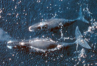
The bowhead whale is a species of baleen whale belonging to the family Balaenidae and is the only living representative of the genus Balaena. It is the only baleen whale endemic to the Arctic and subarctic waters, and is named after its characteristic massive triangular skull, which it uses to break through Arctic ice. Other common names of the species included the Greenland right whale, Arctic whale, steeple-top, and polar whale.

<span class="mw-page-title-main">Operation Fritham</span>

Operation Fritham was an Allied military operation during the Second World War to secure the coal mines on Spitsbergen, the main island of the Svalbard Archipelago, 650 mi (1,050 km) from the North Pole and about the same distance from Norway. The operation was intended to deny the islands to Nazi Germany.

<span class="mw-page-title-main">West Spitsbergen Current</span> Warm, salty current that runs poleward just west of Spitsbergen

The West Spitsbergen Current (WSC) is a warm, salty current that runs poleward just west of Spitsbergen,, in the Arctic Ocean. The WSC branches off the Norwegian Atlantic Current in the Norwegian Sea. The WSC is of importance because it drives warm and salty Atlantic Water into the interior Arctic. The warm and salty WSC flows north through the eastern side of Fram Strait, while the East Greenland Current (EGC) flows south through the western side of Fram Strait. The EGC is characterized by being very cold and low in salinity, but above all else it is a major exporter of Arctic sea ice. Thus, the EGC combined with the warm WSC makes the Fram Strait the northernmost ocean area having ice-free conditions throughout the year in all of the global ocean.

<span class="mw-page-title-main">Nordic Seas</span>

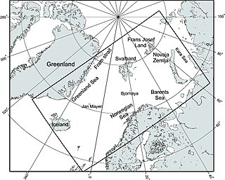
The Nordic Seas are located north of Iceland and south of Svalbard. They have also been defined as the region located north of the Greenland-Scotland Ridge and south of the Fram Strait-Spitsbergen-Norway intersection. Known to connect the North Pacific and the North Atlantic waters, this region is also known as having some of the densest waters, creating the densest region found in the North Atlantic Deep Water. The deepest waters of the Arctic Ocean are connected to the worlds other oceans through Nordic Seas and Fram Strait. There are three seas within the Nordic Sea: Greenland Sea, Norwegian Sea, and Iceland Sea. The Nordic Seas only make up about 0.75% of the World's Oceans. This region is known as having diverse features in such a small topographic area, such as the mid oceanic ridge systems. Some locations have shallow shelves, while others have deep slopes and basins. This region, because of the atmosphere-ocean transfer of energy and gases, has varying seasonal climate. During the winter, sea ice is formed in the western and northern regions of the Nordic Seas, whereas during the summer months, the majority of the region remains free of ice.

<span class="mw-page-title-main">Operation Gearbox</span>

Operation Gearbox was a joint Norwegian and British operation to occupy the Arctic island of Spitsbergen during the Second World War. It superseded Operation Fritham, an expedition in May, to secure the coal mines on Spitsbergen, the main island of the Svalbard Archipelago which had failed when attacked by four German Focke-Wulf Fw 200 Condor reconnaissance bombers. The Norwegian force, with 116 long tons (118 t) of supplies, arrived by British cruiser on 2 July.

References

  1. 1 2 3 4 5 6 "Greenland Sea" (in Russian). Great Soviet Encyclopedia. Archived from the original on 14 May 2013. Retrieved 5 September 2010.
  2. 1 2 3 4 5 6 7 8 9 "Greenland Sea". Encyclopædia Britannica on-line.
  3. Greenland Sea, MarBEF Data System – European Marine Gazetteer
  4. Reddy, M. P. M. (2001). Descriptive Physical Oceanography. Taylor & Francis. p. 8. ISBN   978-90-5410-706-4.
  5. Serreze, Mark C.; Barry, Roger Graham (2005). The Arctic climate system. Cambridge University Press. p. 19. ISBN   978-0-521-81418-8 . Retrieved 27 November 2010.
  6. Blindheim, Johan; Østerhus, Svein (2005). "The Nordic Seas, Main Oceanographic Features". In Drange, Helge (ed.). The Nordic seas: an integrated perspective : oceanography, climatology, biogeochemistry, and modeling. American Geophysical Union. pp. 11–38. ISBN   978-0-87590-423-8.
  7. Loeng, Harald (2005). "Chapter 9: Marine Systems". In Symon, Carolyn (ed.). Arctic Climate Impact Assessment. Cambridge University Press. pp. 453–493. ISBN   978-0-521-86509-8 . Retrieved 27 November 2010.
  8. Meincke, J; Rudels, B; Friedrich, H J (1997). "The Arctic Ocean–Nordic Seas thermohaline system". ICES Journal of Marine Science. 54 (3): 283–299. doi: 10.1006/jmsc.1997.0229 .
  9. "Limits of Oceans and Seas, 3rd edition" (PDF). International Hydrographic Organization. 1953. Archived from the original (PDF) on 8 October 2011. Retrieved 28 December 2020.
  10. Norwegian North-Atlantic Expedition (1876–1878), also
  11. 1 2 3 Matt Walker (22 July 2015). "secret whale refuge". BBC Earth. Retrieved 27 October 2015.
  12. "Speaking With the Men of the Record-Breaking Polar Row Expedition". Men's Journal. 8 September 2017. Retrieved 20 April 2018.
  13. "First row across the Greenland Sea". Guinness World Records. Retrieved 3 June 2018.
  14. Baum, Steven K. (26 May 2004), Glossary of Physical Oceanography and Related Disciplines, p. 194, CiteSeerX   10.1.1.126.3754
  15. Soltwedel, T., Miljutina, M., Mokievsky, V., Thistle, D., Vopel, K. (2003). "The meiobenthos of the Molloy Deep (5600 m), Fram Strait, Arctic Ocean". Vie et Milieu . 53 (1): 1–13. hdl:10013/epic.16261.{{cite journal}}: CS1 maint: multiple names: authors list (link)
  16. "Aspects of the Coast of Northeast Greenland". Bulletin of the American Geographical Society. 41 (2): 92–94. 1909. doi:10.2307/200794. JSTOR   200794.
  17. Islands of Greenland (Denmark) Archived 19 April 2016 at the Wayback Machine , United Nations Environment Programme (UNEP)
  18. Rigge, Simon (1980), War in the Outposts, pp. 24–25. Alexandria, Virginia: Time-Life Books, ISBN   0809433818.
  19. 1 2 van Aken; Hendrik Mattheus (2007). The oceanic thermohaline circulation: an introduction. pp. 127–130. ISBN   978-0-387-36637-1.
  20. 1 2 Malanotte-Rizzoli, Paola; Robinson, Allan R. (1994). Ocean processes in climate dynamics: global and mediterranean examples. Springer. pp. 216–217. ISBN   0-7923-2624-5.
  21. Johnsen, Geir; Sakshaug, Egil; Kovacs, Kit (2009). Ecosystem Barents Sea. Tapir Academic Press. ISBN   978-82-519-2461-0.
  22. Feldhamer, George A.; Thompson, Bruce Carlyle; Chapman, Joseph A. (2003). Wild mammals of North America: biology, management, and conservation. JHU Press. p. 812. ISBN   0-8018-7416-5.
  23. Mowat, Farley (2004). Sea of slaughter. Stackpole Books. p. 341. ISBN   0-8117-3169-3.
  24. Fra meteorologihistorien: Orkanen i Vestisen, april 1952 (From meteorology story: Hurricane, West Ice, April 1952), The Norwegian Meteorological Institute, 4 April 2008 (in Norwegian)
  25. Orkanen i Vestisen april 1952. fiskeribladetfiskaren.no, 8 April 2008 (in Norwegian)
  26. Davidsen, Av Bjørn (8 April 2008) Da alarmen gikk i Vestisen Archived 19 January 2011 at the Wayback Machine , FiskeribladetFiskaren (in Norwegian)
  27. Arnold Farstad: Mysteriet i Vestisen: selfangsttragedien som lamslo nasjonen, ("The West Ice Mystery: The Seal Hunting Tragedy that Stunned the Nation") Samlaget, 2001, ISBN   82-521-5849-8
  28. Comiso, Josefino (2010). Polar Oceans from Space. Springer. pp. 366, 383. ISBN   978-0-387-36628-9.
  29. Carbon Cycling in Arctic Marine Ecosystems: Case Study Young Sound. Museum Tusculanum Press. 2007. pp. 20–21. ISBN   978-87-635-1278-7.
  30. Peter Wadhams (2016). A Farewell to Ice: A Report from the Arctic. p. 148. ISBN   9780190691158.
  31. "90 Billion Barrels of Oil and 1,670 Trillion Cubic Feet of Natural Gas Assessed in the Arctic". US Geological Survey (USGS). 23 July 2008. Retrieved 17 April 2016.
  32. "Assessment of Undiscovered Oil and Gas Resources of the East Greenland Rift Basins Province" (PDF). US Geological Survey (USGS). August 2007. Retrieved 17 April 2016.
  33. 1 2 Kevin Casey (20 January 2014). "Greenland's New Frontier: Oil and Gas Licenses Issued, Though Development Likely Years Off". The Arctic Institute. Archived from the original on 27 April 2016. Retrieved 16 April 2016.
  34. "Current Licences". Bureau of Mineral and Petroleum (Greenland). Archived from the original on 13 May 2016. Retrieved 16 April 2016.
  35. "Map of exclusive hydrocarbon licences" (PDF). Bureau of Mineral and Petroleum (Greenland). February 2016. Archived from the original (PDF) on 13 May 2016. Retrieved 16 April 2016.
  36. "Approved Hydrocarbon Activities". Bureau of Mineral and Petroleum (Greenland). 31 October 2015. Archived from the original on 13 May 2016. Retrieved 16 April 2016.
  37. "Managing Arctic resources". ExxonMobil. Retrieved 16 April 2016.
  38. 1 2 Kevin McGwin (12 December 2013). "If Exxon speaks, will oil industry listen?". The Arctic Journal. Archived from the original on 17 April 2016. Retrieved 16 April 2016.

Further reading