Related Research Articles
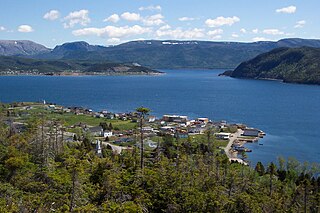
Glovertown is a town in northeastern Newfoundland, Newfoundland and Labrador, Canada. It is in Division No. 7 on Alexander Bay.
St. George's Bay - informally referred to as Bay St. George due to its French translation Baie St-George - is a large bay in the province of Newfoundland and Labrador, Canada. It is located on the west coast of the island of Newfoundland and comprises a sub-basin of the Gulf of St. Lawrence.

Curling is a mainly residential neighbourhood of the city of Corner Brook, Newfoundland and Labrador. It is situated just west of the main part of the city. Located in the Humber Arm of the Bay of Islands, Curling was originally a fishing community. It is the oldest section of Corner Brook.
Steady Brook is a Canadian town in the province of Newfoundland and Labrador. Located on the west coast of the island of Newfoundland, the town is situated 8 kilometres east of the city of Corner Brook in the lower Humber Valley. The town is surrounded by the Long Range Mountains and sits astride the Humber River. Steady Brook has become a thriving community in recent years as a result of provincial investments in the Marble Mountain alpine ski resort, along with golf courses and other recreational amenities.
Woody Point is a town located in the heart of Gros Morne National Park, on the western coast of Newfoundland. Situated on Bonne Bay, the Town of Woody Point encompasses three areas: Curzon Village, Woody Point and Winterhouse Brook. It has a total population of 281 residents. Woody Point is a Registered Heritage District and has a waterfront with many heritage buildings and four Registered Newfoundland and Labrador Heritage Structures. The community is served by Route 431.
Barachois Brook is a local service district and designated place in the Canadian province of Newfoundland and Labrador. It is on the western coast of the province, on Bay St. George, located just 5 km south of Stephenville Crossing.
Merasheen Island is an island in Newfoundland and Labrador, Canada. With a length of approximately 35 km and a width at its widest point of 9 km, it is situated about 6 km from Presque. It is the largest island in the Placentia Bay.
Massey Drive is a Canadian town located on the west coast of the island of Newfoundland in the province of Newfoundland and Labrador. Its name is derived from the original road through the town, named Massey Drive, which in turn is named after Vincent Massey, former Governor General of Canada (1952–59). It is adjacent to the city of Corner Brook, from which it seceded in 1971. It is primarily a residential area.
Indian Bay is located in Newfoundland, Canada.

Comfort Cove-Newstead is a small fishing community located outside Campbellton, on the east coast of Newfoundland and Labrador, Canada,.
Hughes Brook is a town in the Canadian province of Newfoundland and Labrador. The town had a population of 255 in the Canada 2016 Census. It is located to the northeast of Corner Brook, in the western Bay of Islands area.
Whiteway is a town in the Canadian province of Newfoundland and Labrador. The town had a population of 373 in the Canada 2016 Census.

Black Duck Brook and Winterhouse is a local service district and designated place in the Canadian province of Newfoundland and Labrador. It consists of the unincorporated fishing settlements of Black Duck Brook and Winterhouse on the Port au Port Peninsula. The communities had a combined population of 57 in the Canada 2006 Census.
Muddy Bay is a former settlement on the coast of Labrador in the province of Newfoundland and Labrador, Canada. It was located on the shore of Muddy Bay, a small bay of Favorite Tickle.
Connoire Bay is natural bay or cove on the island of Newfoundland in the province of Newfoundland and Labrador, Canada. Miffel Island is nearby.
Woody Bay is a natural bay on the island of Newfoundland in the province of Newfoundland and Labrador, Canada.

Ingornachoix Bay is a natural bay on the island of Newfoundland in the province of Newfoundland and Labrador, Canada. It is located approximately mid-way along the western shore of the Great Northern Peninsula. Home to three beautiful villages, Port aux Choix, Port Saunders and Hawkes Bay.
Rocky Bay is a natural bay off the island of Newfoundland in the province of Newfoundland and Labrador, Canada.
Muddy Bay is a bay on the coast of Labrador in the province of Newfoundland and Labrador, Canada. It is a small eastern inlet of Favorite Tickle, a strait connecting Sandwich Bay in the south with the Atlantic Ocean in the north. The bay has a maximum depth between 18 and 20 meters.
Sandwich Bay, is a natural bay on the coast of Labrador in the province of Newfoundland and Labrador, Canada. The principal permanent settlement is Cartwright, located at the south entrance to the inner part of the bay. Other settlements along the bay include Paradise River and North River. Both of these communities are located at the outlets of the rivers of the same name into the bay. The is a road following the entire eastern coastline of Sandwich Bay, Newfoundland and Labrador Route 516.
References
- ↑ United States Hydrographic Office; Davenport, Richard G. (1884). Newfoundland and Labrador: The coast and banks of Newfoundland and the coast of Labador, from Grand Point to the Koksoak River, with the adjacent islands and banks (Public domain ed.). Govt. print. off. pp. 536–. Retrieved 20 November 2011.
- ↑ "Northwest Brook". Canadian Geographical Names Database (CGNDB). Government of Canada. Retrieved 3 April 2022.
Coordinates: 54°28′56″N57°31′43″W / 54.4822°N 57.5287°W
| | This Labrador location article is a stub. You can help Wikipedia by expanding it. |