Alboran Sea

Last updated
Alboran Sea
Mar de Alborán
Mar de Alboran - BM WMS 2004.jpg
Relief Map of Mediterranean Sea.png
Red pog.svg
Alboran Sea
Morocco relief location map.jpg
Red pog.svg
Alboran Sea
Relief Map of Spain.png
Red pog.svg
Alboran Sea
Algeria relief location map.jpg
Red pog.svg
Alboran Sea
Location Southern Europe and North Africa
Coordinates 36°0′N3°0′W / 36.000°N 3.000°W / 36.000; -3.000
River sources Guadalhorce River, Guadalfeo River, Adra River (Spain) and Nekor River (Morocco)
Ocean/sea sourcesAtlantic Ocean
Basin  countries Algeria, Gibraltar (UK), Morocco, and Spain
Average depth445 metres (1,460 ft)
Max. depth1,500 metres (4,900 ft)
Settlements Málaga, Marbella, Motril, Almería and Cartagena, Spain
Alhucemas and Nador, Morocco, Gibraltar

The Alboran Sea is the westernmost portion of the Mediterranean Sea, lying between the Iberian Peninsula and the north of Africa (Spain on the north and Morocco and Algeria on the south). The Strait of Gibraltar, which lies at the west end of the Alboran Sea, connects the Mediterranean with the Atlantic Ocean.

Contents

A satellite image centred on the Alboran Sea. To the left, the Iberian Peninsula, and to the right, the north of Africa. STS059-238-074 Strait of Gibraltar.jpg
A satellite image centred on the Alboran Sea. To the left, the Iberian Peninsula, and to the right, the north of Africa.

Geography

Its average depth is 445 metres (1,460 ft) and maximum depth is 1,500 metres (4,900 ft).

The International Hydrographic Organization defines the limits of the Alboran Sea as follows: [1]

On the West. The Eastern limit of the Strait of Gibraltar: A line joining from tip (Europa Point) of Cap Gibraltar in Europe to the tip of the Península de Almina of Ceuta in Africa ( 35°54′N5°18′W / 35.900°N 5.300°W / 35.900; -5.300 ).

On the East. A line joining from Cabo de Gata in Andalusia in Europe to Cap Fegalo, near Oran, Algeria in Africa ( 35°36′N1°12′W / 35.600°N 1.200°W / 35.600; -1.200 ).

Several small islands dot the sea, including the eponymous Isla de Alborán. Most, even those close to the African shore, belong to Spain.

Geology

The Alboran domain, the seafloor beneath the Alboran Sea (known as the internal zones) together with the surrounding mountains (known as the external zones; the Gibraltar Arc and Atlas Mountains), is mostly made of continental crust and marks the westernmost terminus of the terranes that were subducted between the African and Eurasian Plates when the Tethys Ocean closed. Reoccurring earthquakes at a depth of about 600 km (370 mi) indicate that this subduction is ongoing and that complex interactions between the lithosphere and mantle are forming the region. [2] The internal zones are made of Late Paleozoic to Triassic rocks that were piled up during the Tertiary and has been extended since the Early Miocene. [3]

The seafloor is morphologically complex with several sub-basins, including three main sub-basins named West, East, and South Alboran Basins, ridges, and seamounts. The most prominent structure in the Alboran Sea is the 180 km long (110 mi) Alboran Ridge which stretches southwest from the volcanic Alborán Island. [4]

Oceanography

Surface currents in the Alboran Sea, influenced by the prevailing winds, flow eastward, bringing water from the Atlantic into the Mediterranean; deeper subsurface currents flow westward, carrying saltier Mediterranean water over the Gibraltar sill into the Atlantic. Thus there is typically a vertical rotary circulation, also known as a gyre, in the Alboran Sea as a result of this exchange of water. [5]

Ecology

Map of the Alboran Sea Alboran Sea map.png
Map of the Alboran Sea

The Alboran Sea is a transition zone between ocean and sea, containing a mix of Mediterranean and Atlantic species. The Alboran Sea is habitat for the largest population of bottlenose dolphins and the last population of harbour porpoises in the western Mediterranean, and is the most important feeding grounds for loggerhead sea turtles in Europe. The Alboran sea also hosts important commercial fisheries, including sardines and swordfish. In 2003, the World Wildlife Fund raised concerns about the widespread drift net fishing endangering populations of dolphins, turtles, as well as other marine animals. In 2023, the European Union, Morocco, and Algeria agreed to ban bottom fishing practices around Cabliers Bank, protecting the only cold-water coral reef known to be growing in the Mediterranean. [6]

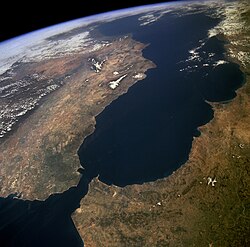
An arc of mountains, known as the Gibraltar Arc, wraps around the northern, western and southern sides of the Alboran Sea. The Gibraltar Arc is made up of the Baetic Cordillera of Southern Spain and the Rif Mountains of Morocco. These mountains, known to ecologists as the Baetic-Rifan complex, comprise one of the Mediterranean's biodiversity hotspots; like the Alboran Sea, the Baetic-Rifan complex represents a transition between the Mediterranean and Atlantic (Macaronesian) ecological zones. The moderating influence of the Atlantic has allowed many relict species in the Baetic and Rif mountains to survive the climatic fluctuations of the last few million years that have caused them to become extinct elsewhere around the Mediterranean basin.

Islands

There are some small islands in the sea: [7]

Related Research Articles

<span class="mw-page-title-main">Mediterranean Sea</span> Sea between Europe, Africa and Asia

The Mediterranean Sea is a sea connected to the Atlantic Ocean, surrounded by the Mediterranean Basin and almost completely enclosed by land: on the north by Southern Europe and Anatolia, on the south by North Africa, and on the east by the Levant in West Asia. The Mediterranean has played a central role in the history of Western civilization. Geological evidence indicates that around 5.9 million years ago the Mediterranean was cut off from the Atlantic and was partly or completely desiccated over a period of some 600,000 years during the Messinian salinity crisis before being refilled by the Zanclean flood about 5.3 million years ago.

<span class="mw-page-title-main">Geography of Morocco</span> Overview of the geography of Morocco

Morocco is the northwesternmost country which spans from the Mediterranean Sea and Atlantic Ocean on the north and the west respectively, into large mountainous areas in the interior, to the Sahara desert in the far south. Morocco is a Northern African country, located in the extreme northwest of Africa on the edge of continental Europe. The Strait of Gibraltar separates Spain from Morocco with a 13 kilometres (8.1 mi) span of water. Morocco borders the North Atlantic Ocean to the west, and the western Mediterranean Sea to the north, and has borders with Algeria and disputed Western Sahara.

<span class="mw-page-title-main">Geography of Spain</span> Overview of the geography of Spain

Spain is a country located in southwestern Europe occupying most of the Iberian Peninsula. It also includes a small exclave inside France called Llívia, as well as the Balearic Islands in the Mediterranean, the Canary Islands in the Atlantic Ocean 108 km (67 mi) off northwest Africa, and five places of sovereignty on and off the coast of North Africa: Ceuta, Melilla, Islas Chafarinas, Peñón de Alhucemas, and Peñón de Vélez de la Gomera.

<span class="mw-page-title-main">Strait of Gibraltar</span> Strait connecting the Atlantic to the Mediterranean

The Strait of Gibraltar is a narrow strait that connects the Atlantic Ocean to the Mediterranean Sea and separates Europe from Africa. The two continents are separated by 13 kilometres of ocean at the Strait's narrowest point between Punta de Tarifa in Spain and Point Cires in Morocco. Ferries cross between the two continents every day in as little as 35 minutes. The Strait's depth ranges between 300 and 900 metres.

<span class="mw-page-title-main">Alhucemas Islands</span> Island group

The Alhucemas Islands is a group of islands and one of the Spanish plazas de soberanía just off the Moroccan coast in the Alboran Sea.

<i>Plazas de soberanía</i> Spanish territories along the northern African coast

The plazas de soberanía are a series of Spanish overseas minor territories scattered along the Mediterranean coast bordering Morocco in Africa, or that are closer to Africa than Europe. This term is used for those territories that have been a part of Spain since the formation of the modern country (1492–1556), as opposed to African territories acquired by Spain during the 19th and early 20th centuries in the Scramble for Africa.

<span class="mw-page-title-main">Rif</span> Geographic and cultural region of Morocco

The Rif or Riff, also called Rif Mountains, is a geographic region in northern Morocco. It is bordered on the north by the Mediterranean Sea and Spain and on the west by the Atlantic Ocean, and is the homeland of the Rifians and the Jebala people. This mountainous and fertile area is bordered by Cape Spartel and Tangier to the west, by Berkane and the Moulouya River to the east, by the Mediterranean to the north, and by the Ouergha River to the south. The Rif mountains are separated into the eastern Rif mountains and western Rif mountains.

<span class="mw-page-title-main">Baetic System</span>

The Baetic System or Betic System is one of the main systems of mountain ranges in Spain. Located in the southern and eastern Iberian Peninsula, it is also known as the Cordilleras Béticas or Baetic Mountains. The name of the mountain system derives from the ancient Roman region of Baetica, one of the Imperial Roman provinces of ancient Hispania.

<span class="mw-page-title-main">Messinian salinity crisis</span> Drying-up of the Mediterranean Sea from 5.96 to 5.33 million years ago

The Messinian salinity crisis was a geological event during which the Mediterranean Sea went into a cycle of partial or nearly complete desiccation (drying-up) throughout the latter part of the Messinian age of the Miocene epoch, from 5.96 to 5.33 Ma. It ended with the Zanclean flood, when the Atlantic reclaimed the basin.

<span class="mw-page-title-main">Mediterranean Basin</span> Region of lands around the Mediterranean Sea that have a Mediterranean climate

In biogeography, the Mediterranean Basin, also known as the Mediterranean Region or sometimes Mediterranea, is the region of lands around the Mediterranean Sea that have mostly a Mediterranean climate, with mild to cool, rainy winters and warm to hot, dry summers, which supports characteristic Mediterranean forests, woodlands, and scrub vegetation. It was a very important part of Mediterranean civilizations.

<span class="mw-page-title-main">Middle Atlas</span>

The Middle Atlas is a mountain range in Morocco. It is part of the Atlas mountain range, a mountainous region with more than 100,000 km2, 15 percent of its landmass, rising above 2,000 metres. The Middle Atlas is the northernmost and second highest of three main Atlas Mountains chains of Morocco. To south, separated by the Moulouya and Um Er-Rbiâ rivers, lies the High Atlas. The Middle Atlas form the westernmost end of a large plateaued basin extending eastward into Algeria, also bounded by the Tell Atlas to the north and the Saharan Atlas to the south, both lying largely in Algeria. North of the Middle Atlas and separated by the Sebou River, lie the Rif mountains which are an extension of the Baetic System, which includes the Sierra Nevada in the south of Spain. The basin of the Sebou is not only the primary transportation route between Atlantic Morocco and Mediterranean Morocco but is an area, watered by the Middle Atlas range, that constitutes the principal agricultural region of the country.

<span class="mw-page-title-main">Atlantic sawtail catshark</span> Species of shark

The Atlantic sawtail catshark is a little-known species of catshark, part of the family Scyliorhinidae, found in a small area of the northeastern Atlantic Ocean, centered on the Strait of Gibraltar and the Alborán Sea. It is found on or close to the bottom over the continental slope, mostly at depths of 400–600 m (1,300–2,000 ft). This shark closely resembles, and was once thought to be the same species as, the blackmouth catshark ; both are slender with a series of dark saddles and blotches along the back and tail, and a prominent crest of enlarged dermal denticles along the dorsal edge of the caudal fin. It differs subtly from G. melastomus in characters including snout length, caudal peduncle depth, and the color of the furrows at the corner of its mouth.

<span class="mw-page-title-main">Geology of the Iberian Peninsula</span> Origins, structure, use and study of the rock formations of Spain, Portugal, Andorra and Gibraltar

The geology of the Iberian Peninsula consists of the study of the rock formations on the Iberian Peninsula, which includes Spain, Portugal, Andorra, and Gibraltar. The peninsula contains rocks from every geological period from the Ediacaran to the Quaternary, and many types of rock are represented. World-class mineral deposits are also found there.

<span class="mw-page-title-main">Gibraltar Arc</span>

The Gibraltar Arc is a geological region corresponding to an arcuate orogen surrounding the Alboran Sea, between the Iberian Peninsula and Africa. It consists of the Betic Cordillera, and the Rif. The Gibraltar Arc is located at the western end of the Mediterranean Alpine belt and formed during the Neogene due to convergence of the Eurasian and African plates.

The Azores–Gibraltar Transform Fault (AGFZ), also called a fault zone and a fracture zone, is a major seismic zone in the Eastern Atlantic Ocean between the Azores and the Strait of Gibraltar. It is the product of the complex interaction between the African, Eurasian, and Iberian plates. The AGFZ produced these large-magnitude earthquakes and, consequently, a number of large tsunamis: 1755 Lisbon, 1761 Lisbon, 1816 North Atlantic, 1941 Gloria Fault earthquake, 1969 Horseshoe and 1975.

<span class="mw-page-title-main">Intercontinental Biosphere Reserve of the Mediterranean</span>

The Intercontinental Biosphere Reserve of the Mediterranean is the first of its type to be designated by the Man and the Biosphere Programme. It combines the Tingitan Peninsula in Morocco and the southern Iberian Peninsula of Andalusia. Both countries are located in a biogeographic region of deciduous forests and evergreen sclerophyllous scrub within the Mediterranean bioclimatic zone. The maritime area of the biosphere reserve is dominated by the Strait of Gibraltar, which links the two peninsulas. The reserve also encompasses natural and human communication routes between Africa and Europe.

<span class="mw-page-title-main">Aquatic sill</span> A sea floor barrier of relatively shallow depth restricting water movement between oceanic basins

An aquatic sill is a sea floor barrier of relatively shallow depth that restricts water movement between benthic zones of an oceanic basin or lake bottom. There are roughly 400 sills in the Earth's oceans, covering 0.01% of the seafloor. A classic example is the Strait of Gibraltar Gateway between the Mediterranean sea and the Atlantic Ocean.

<span class="mw-page-title-main">Zanclean flood</span> Theoretical refilling of the Mediterranean Sea between the Miocene and Pliocene Epochs

The Zanclean flood or Zanclean deluge is theorized to have refilled the Mediterranean Sea 5.33 million years ago. This flooding ended the Messinian salinity crisis and reconnected the Mediterranean Sea to the Atlantic Ocean, although it is possible that even before the flood there were partial connections to the Atlantic Ocean. The reconnection marks the beginning of the Zanclean age.

The 2016 Alborian Sea earthquake struck offshore, north northeast of Al Hoceïma, Morocco in the Strait of Gibraltar on January 25 at 04:22:02 UTC, or roughly 05:22:02 West Africa Time. At its strongest in the Alboran Sea, the earthquake measured 6.3–6.4 on the moment magnitude scale (Mw ) at a shallow hypocenter depth of 12 km (7.5 mi). Assigned a maximum Modified Mercalli scale intensity of VI (Strong), the earthquake caused one fatality, injuries to at least 30 persons, and moderate damage in Morocco and Spain.

<span class="mw-page-title-main">Topography of Spain</span>

The topographical relief of Spain is characterized by being quite high, with an average altitude of 660 meters above sea level, quite mountainous compared to other European countries and only surpassed by Switzerland, Austria, Greece and the microstates of Andorra and Liechtenstein. In peninsular Spain, the terrain is articulated around a large Meseta Central that occupies most of the center of the Iberian Peninsula. Outside the plateau, there is the depression of the Guadalquivir river, located in the southwest of the peninsula, and the Ebro river depression, located in the northeast.

References

Notes

  1. "Limits of Oceans and Seas, 3rd edition" (PDF). International Hydrographic Organization. 1953. Archived from the original (PDF) on 8 October 2011. Retrieved 28 December 2020.
  2. Alpert et al. 2013, Introduction, pp. 4265–4266.
  3. Iribarren et al. 2007, Introduction, p. 98.
  4. Comas et al. 1999, p. 559.
  5. C. Michael Hogan. 2011. "Alboran Sea" in. eds. P. Saundry & C. J. Cleveland. Encyclopedia of Earth. (National Council for Science and the Environment) Washington DC
  6. "Mediterranean countries unite to protect unique deep-sea coral from fishing impacts". europe.oceana.org. Retrieved 2023-11-17.
  7. "Map of Alboran Sea - Alboran Sea Map, World Seas, Alboran Location - World Atlas". www.worldatlas.com. Retrieved 2017-10-12.
  8. "Alboran Sea - a sea in Atlantic Ocean". www.deepseawaters.com. Retrieved 2017-10-12.

Sources