
Cape Agulhas is a rocky headland in Western Cape, South Africa. It is the geographic southern tip of Africa and the beginning of the traditional dividing line between the Atlantic and Indian Oceans according to the International Hydrographic Organization. It is approximately half a degree of latitude, or 55 kilometres (34 mi), further south than the Cape of Good Hope.
Hotagterklip is a small hamlet on the South African coast, close to the village of Struisbaai in the Western Cape.

Overstrand Municipality is a local municipality in the Western Cape province of South Africa. It is located along the Atlantic coast between Cape Town and Cape Agulhas, within the Overberg District Municipality. The principal towns in the municipality are Hermanus, Gansbaai and Kleinmond. As of 2011 it had a population of 80,432.
Cape Agulhas Municipality is a municipality located in the Western Cape Province of South Africa. As of 2011 it had a population of 33,038. Its municipality code is WC033. It is named after Cape Agulhas, the southernmost point of Africa. The largest town is Bredasdorp, which is the seat of the municipal headquarters. It also includes the villages of Napier, Struisbaai, Elim, Arniston and L'Agulhas, and the De Hoop Nature Reserve.

Swellendam Municipality is a municipality located in the Western Cape Province of South Africa. As of 2011 it had a population of 35,916. Its municipality code is WC034.

Strand is a seaside resort town in the Western Cape, South Africa. It forms part of the Helderberg region of the City of Cape Town Metropolitan Municipality, situated on the north-eastern edge of False Bay and near the foot of the Helderberg Mountains. Its geographical position is between Somerset West and Gordon's Bay, and is about 50 km southeast of Cape Town City Bowl. Strand has a population of approximately 50,000. Strand's main attraction is the beach; 5 km of white sandy beach off False Bay.

The Overberg District Municipality is a district municipality that governs the Overberg region in the Western Cape province of South Africa. It is divided into four local municipalities and includes the major towns of Grabouw, Caledon, Hermanus, Bredasdorp and Swellendam. The municipal area covers 12,241 square kilometres (4,726 sq mi) and had in 2007 an estimated population of 212,787 people in 60,056 households.

Gansbaai is a fishing town and popular tourist destination in the Overberg District Municipality, Western Cape, South Africa. It is known for its dense population of great white sharks and as a whale-watching location.

Arniston is a small seaside settlement on the coast of the Overberg region of South Africa, close to Cape Agulhas, the southernmost tip of Africa. Prior to the wreck of Arniston, it is also known as Waenhuiskrans, an Afrikaans name meaning literally "Wagon house cliff", after a local sea cave large enough to accommodate a wagon and a span of oxen.

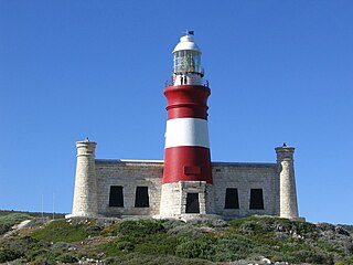
L Agulhas is the most southern coastal village and holiday resort in South Africa, located within the Cape Agulhas Local Municipality at the southernmost tip of the African mainland. It is situated next to the town of Struisbaai and about 30 kilometres (20 mi) south of the regional centre of Bredasdorp. The name "Agulhas", Portuguese for "needles", is said to have been given to the cape because the compass-needle was seen to point due north, that is, with no magnetic deviation. The Agulhas Bank is reputed to be the richest fishing area in the Southern Hemisphere. Some of the older residents and documents refer to the town as by its former name Cape Agulhas or Cape L'Agulhas or simply Agulhas which were the names that referred to this town before it was changed to L'Agulhas to avoid confusion when the Bredasdorp Municipality changed its name to The Cape Agulhas Municipality (CAM).
Melkbosstrand is a coastal town located on the South West Coast of South Africa, 30 km north of Cape Town. It forms part of the City of Cape Town Metropolitan Municipality, the municipality governing Cape Town and its greater metropolitan area.

Napier is a village at the foot of the Soetmuisberg, between Caledon and Bredasdorp. A blend of century-old cottages and modern houses, surrounded by the rolling farmland which typifies the Overberg region of South Africa, give the village a rural atmosphere.
Betty's Bay is a small holiday town situated on the Overberg coast of South Africa's Western Cape province. It is located 100 km from Cape Town beneath the Kogelberg Mountains on the scenic R44 ocean drive between Pringle Bay and Kleinmond. This village stretches over 13 km along the coast. Tourism plays a large role in the town's economy due to its popularity with holiday makers from across the Western Cape and Cape Town in particular.

Bredasdorp is a town in the Southern Overberg region of the Western Cape, South Africa, and the main economic and service hub of that region. It lies on the northern edge of the Agulhas Plain, about 160 kilometres (100 mi) south-east of Cape Town and 35 kilometres (22 mi) north of Cape Agulhas, the southernmost tip of Africa.
The Agulhas National Park is a South African national park located in the Agulhas Plain in the southern Overberg region of the Western Cape, about 200 kilometres (120 mi) south-east of Cape Town. The park stretches along the coastal plain between the towns of Gansbaai and Struisbaai, and includes the southern tip of Africa at Cape Agulhas. As of January 2009 it covered an area of 20,959 hectares. Although one of the smallest national parks in South Africa, it boasts 2,000 native plant species and a wetland that provides refuge to birds and amphibians.

A slave mutiny on Meermin, one of the Dutch East India Company's fleet of slave ships, took place in February 1766 and lasted for three weeks. Her final voyage was cut short by the mutiny of the Malagasy captives onboard, who had been sold to Dutch East India Company officials on Madagascar to be enslaved by the company in its Cape Colony in southern Africa. During the mutiny half the ship's crew and almost 30 Malagasy captives died.
Meermin was an 18th-century Dutch cargo ship of the hoeker type, one of many built and owned by the Dutch East India Company. She was laid down in 1759 and fitted out as a slave ship before her maiden voyage in 1761, and her career was cut short by a mutiny of her cargo of Malagasy people. They had been sold to Dutch East India Company officials on Madagascar, to be used as company slaves in its Cape Colony in southern Africa. Half her crew and almost 30 Malagasy lost their lives in the mutiny; the mutineers deliberately allowed the ship to drift aground off Struisbaai, now in South Africa, in March 1766, and she broke up in situ. As of 2013, archaeologists are searching for the Meermin's remains.

Madagascar–South Africa relations refers to the diplomatic relations between Madagascar and South Africa. Both nations are members of the African Union, Group of 77, Non-Aligned Movement and the Southern African Development Community.
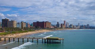
This is a list of seaside resorts in South Africa. These seaside resorts are in the Eastern Cape, KwaZulu-Natal, Northern Cape and Western Cape provinces which are all coastal provinces of South Africa.
Tesselaarsdal is a dispersed rural settlement in the Theewaterskloof Municipality, Western Cape, South Africa. It is situated on the northern side of the Kleinrivier Mountains, 20 kilometres (12 mi) south of the town of Caledon. The 2011 census recorded a population of 1,395 people in 428 households in Tesselaarsdal and on the surrounding farms.


