
Fairport Harbor is a village in Lake County, Ohio, United States, along Lake Erie at the mouth of the Grand River. The population was 3,109 at the 2010 census.

Mossel Bay is a harbour town of about 99,319 people on the Southern Cape of South Africa. It is an important tourism and farming region of the Western Cape Province. Mossel Bay lies 400 kilometres east of the country's seat of parliament, Cape Town, and 400 km west of Gqeberha, the largest city in the Eastern Cape. The older parts of the town occupy the north-facing side of the Cape St Blaize Peninsula, whilst the newer suburbs straddle the Peninsula and have spread eastwards along the sandy shore of the Bay.
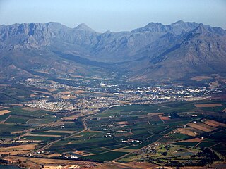
Stellenbosch is a town in the Western Cape province of South Africa, situated about 50 kilometres east of Cape Town, along the banks of the Eerste River at the foot of the Stellenbosch Mountain. The town became known as the City of Oaks or Eikestad in Afrikaans and Dutch due to the large number of oak trees that were planted by its founder, Simon van der Stel, to grace the streets and homesteads.

Overstrand Municipality is a local municipality in the Western Cape province of South Africa. It is located along the Atlantic coast between Cape Town and Cape Agulhas, within the Overberg District Municipality. The principal towns in the municipality are Hermanus, Gansbaai and Kleinmond. As of 2011 it had a population of 80,432.

Bergrivier Local Municipality is a local municipality in the Western Cape province of South Africa. It governs the towns of Piketberg, Velddrif and Porterville, as well as the surrounding villages and rural areas. As of 2011 it had a population of 61,897. It is located within the West Coast District Municipality and has municipality code WC013.
Hessequa Local Municipality is a municipality located in the Western Cape Province of South Africa. It is flanked by the lower Breede River to the west and the Gourits River to the east. As of 2011 the population was 52,642. Its municipality code is WC042. The name Hessequa, meaning "people of the trees", refers to the tribe of indigenous Khoikhoi people.

Matzikama Local Municipality is a local municipality which governs the northernmost part of the Western Cape province of South Africa, including the towns of Vredendal, Vanrhynsdorp, Klawer and Lutzville, and the surrounding villages and rural areas. As of 2011 it had a population of 67,147. It forms part of the West Coast District Municipality, and has municipality code WC011.

Swellendam Municipality is a municipality located in the Western Cape Province of South Africa. As of 2011 it had a population of 35,916. Its municipality code is WC034.

Gansbaai is a fishing town and popular tourist destination in the Overberg District Municipality, Western Cape, South Africa. It is known for its dense population of great white sharks and as a whale-watching location.

Rupandehi District, a part of Lumbini Province, is one of the seventy-seven districts of Nepal and covers an area of 1,360 km2 (530 sq mi). The district headquarter is Bhairahawa. As per the national census 2011, the population of Rupandehi was 880,196.
Vhembe is one of the 5 districts of Limpopo province of South Africa. It is the northernmost district of the country and shares its northern border with Beitbridge district in Zimbabwe and on the east with Gaza Province in Mozambique. Vhembe consist of all territories that were part of the former Venda Bantustan, however, two large densely populated districts of the former Tsonga homeland of Gazankulu, in particular, Hlanganani and Malamulele were also incorporated into Vhembe, hence the ethnic diversity of the District. The seat of Vhembe is Thohoyandou, the capital of the former Venda Bantustan. According to 2011 census, the majority of Vhembe residents, about 800,000, speak TshiVenda as their mother language, while 400,000 speak Xitsonga as their home language. However, the Tsonga people are in majority south of Levubu River and they constitute more than 85% of the population in the south of the historic river Levubu, while the Venda are the minority south of Levubu, at 15%. The Northern Sotho speakers number 27,000. The district code is DC34.

Banatska Palanka is a village in Serbia. It is situated in the Bela Crkva municipality, South Banat District, Vojvodina province. The population of the village is 837, of whom 752 (89.84%) are ethnic Serbs.

Saborsko is a village and municipality in Karlovac County, Croatia. The municipality is part of the Lika region.

Bredasdorp is a town in the Southern Overberg region of the Western Cape, South Africa, and the main economic and service hub of that region. It lies on the northern edge of the Agulhas Plain, about 160 kilometres (100 mi) south-east of Cape Town and 35 kilometres (22 mi) north of Cape Agulhas, the southernmost tip of Africa.

Coffee Bay is a town on the Wild Coast of the Eastern Cape Province of South Africa. It is located about 250 kilometres south of the city of Durban and has a population of 258 people.

Pearston is a small town in the eastern Karoo, in the Eastern Cape province of South Africa. It lies between Graaff-Reinet and Somerset East at the foot of the Coetzeesberge, about 160 kilometres (100 mi) north of Port Elizabeth. It falls within the Blue Crane Route Local Municipality and has a population of approximately 4,500 people.

Brooklyn is a suburb of Cape Town, Western Cape with a population of 10,941 people. Brooklyn lies to the north of Maitland, east of the Atlantic Ocean and Paarden Eiland, and west of Air Force Base Ysterplaat. The Black River flows through a section of Brooklyn.
Uilenkraalsmond or Uilenkraal is a populated place located in the village of Franskraalstrand, Overstrand Local Municipality of the Overberg District Municipality, in the Western Cape province of South Africa.


